 W
WThe Ailiao River is a tributary of the Gaoping River in Taiwan. It flows through Kaohsiung City and Pingtung County for 68.5 km.
 W
WThe Bashi Channel is a waterway between Y'Ami Island of the Philippines and Orchid Island of Taiwan. It is a part of the Luzon Strait in the Pacific Ocean. It is characterized by windy storms during the rainy period, June to December.
 W
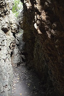
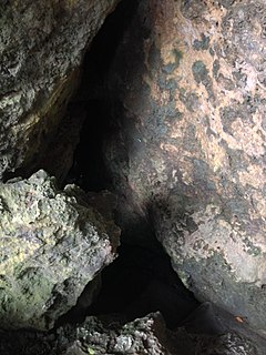
WBeauty Cave is a cave in Liuqiu Township, Pingtung County, Taiwan. It is administered as a scenic area whose ticket also includes access to nearby Mountain Pig Ditch and Black Dwarf Cave.
 W
WBlack Dwarf Cave is a cave and tourist attraction in Tianfu Village on Liuqiu Island, off Pingtung County, Taiwan. Its scenic area includes paths around the surrounding coasts and its ticket includes access to some other nearby attractions such as Mountain Pig Ditch and Beauty Cave.
 W
WCape Eluanbi or Oluanpi, also known by other names, is the southernmost point on Taiwan. It is located in Eluanbi Park near Eluan Village in the township of Hengchun in Pingtung County.
 W
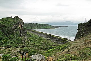
WCape Maobitou is a cape in the township of Hengchun in Pingtung County, Taiwan. It lies within Kenting National Park and forms the western boundary of South Bay. It is one of the southernmost points on Taiwan Island.
 W
WDapeng Bay or Wan is a lagoon in Donggang Township, Pingtung County, Taiwan. It is the largest lagoon on the southwest coastline of Taiwan Island.
 W
WThe Donggang River is a river in Taiwan. It flows through Pingtung County for 44 km.
 W
WThe Dongyuan Wetland is a wetland in Mudan Township, Pingtung County, Taiwan.
 W
WThe Frog Rock is a rock in Hengchun Township, Pingtung County, Taiwan. The rock is part of Kenting National Park.
 W
WThe Gaoping River, also spelled Kaoping River, is a major river of southern Taiwan, flowing through Pingtung County and Kaohsiung City. It is the largest river in Taiwan by drainage area. The river is 171 kilometres (106 mi) long, draining a rugged area on the western side of the Central Mountain Range.
 W
WThe Linbian River is a river in Taiwan. It flows through Pingtung County for 42 km.
 W
WLiuqiu, also known by several other names, is a coral island in the Taiwan Strait about 13 kilometers (8 mi) southwest of Taiwan Island. It has an area of 6.8 km2 (2.6 sq mi) and approximately 13,000 residents, the vast majority of whom share only 10 surnames. It is administered as a township of Pingtung County. The current township chief is Chen Lung-chin.
 W
WLobster Cave is a cave on Liuqiu Island, off Pingtung County, Taiwan.
 W
WThe Longluan Lake is a lake in Kenting National Park, Hengchun Township, Pingtung County, Taiwan. It is the biggest fresh water lake in Taiwan.
 W
WThe Pekingese Dog Rock is a rock in Green Island, Taitung County, Taiwan.
 W
WPingtung Plain is a plain area including parts of Pingtung County and Kaohsiung City in Taiwan. It includes the alluvial fan of Kaoping River, which forms the largest drainage area of rivers in Taiwan, and also passed by other shorter rivers such as Tungkang River, Linbian River and Shihwen River (士文溪). The plain faces the Taiwan Strait on the southwest, lies to the east of Kaohsiung City, and at the west of Central Mountain Range.
 W
WThe Qishan River or Nanzixian River is a tributary of the Gaoping River in Taiwan. It flows through Chiayi County, Kaohsiung City, and Pingtung County for 117 km.
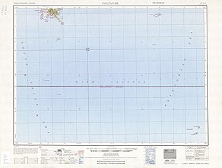
WQixingyan or Ch'ihsingyen, also known as the Vele Rete rocks, is a group of coral islands in the Bashi Channel, located off the southern coast of Pingtung County, Taiwan. The island group is composed by seven coral reefs. At low tide seven reefs are visible. At high tide only two reefs are visible. Qixingyan is shaped like the Big Dipper, hence the name "Seven Star Reef". It is about 8 nautical miles (15 km) from the southernmost point of Taiwan, Eluanbi. Due to strong currents and shoals in the area, many ships were wrecked and lives lost in the early to mid-19th century after the Qing court opened trade between the West and China. Notable shipwrecks include the 1867 US merchant ship Rover that resulted in the Rover incident and the 1871 Japanese merchant vessel Ryukyu which resulted in the Mudan incident.
 W
WThe Sail Rock is a rock in Hengchun Township, Pingtung County, Taiwan. The rock is part of Kenting National Park.
 W
WShouka, formerly known as Kotobuki Pass , is a mountain pass located in southern Taiwan, transversing the Central Mountain Range. Administratively, Shouka is at the border of Shizi, Pingtung and Daren, Taitung.
 W
WThe Sleeping Beauty Rock is a rock in Green Island, Taitung County, Taiwan.
 W
WSouth Bay, also known by other names, is a bay and adjacent beach near Hengchun in Pingtung County, Taiwan. It is part of Kenting National Park.
 W
WVase Rock is a rock just off Liuqiu Island of Pingtung County, Taiwan.
WThe Wuluo River, also spelled Wulo River, (Chinese: 武洛溪; pinyin: Wǔluò Xī; Wade–Giles: Wu3-lo4 Hsi1) is a tributary of the Gaoping River in Pingtung County, Taiwan.