 W
WThe Willamette River is a major tributary of the Columbia River, accounting for 12 to 15 percent of the Columbia's flow. The Willamette's main stem is 187 miles (301 km) long, lying entirely in northwestern Oregon in the United States. Flowing northward between the Oregon Coast Range and the Cascade Range, the river and its tributaries form the Willamette Valley, a basin that contains two-thirds of Oregon's population, including the state capital, Salem, and the state's largest city, Portland, which surrounds the Willamette's mouth at the Columbia.
 W
WThe Christmas flood of 1964 was a major flood in the United States' Pacific Northwest and some of Northern California between December 18, 1964, and January 7, 1965, spanning the Christmas holiday. Considered a 100-year flood, it was the worst flood in recorded history on nearly every major stream and river in coastal Northern California and one of the worst to affect the Willamette River in Oregon. It also affected parts of southwest Washington, Idaho, and Nevada. In Oregon, 17 or 18 people died as a result of the disaster, and it caused hundreds of millions of dollars in damage. The flooding on the Willamette covered 152,789 acres (61,831.5 ha). The National Weather Service rated the flood as the fifth most destructive weather event in Oregon in the 20th century. California Governor Pat Brown was quoted as saying that a flood of similar proportions could "happen only once in 1,000 years," and it was often referred to later as the Thousand Year Flood. The flood killed 19 people, heavily damaged or completely devastated at least 10 towns, destroyed all or portions of more than 20 major highway and county bridges, carried away millions of board feet of lumber and logs from mill sites, devastated thousands of acres of agricultural land, killed 4,000 head of livestock, and caused $100 million in damage in Humboldt County, California, alone.
 W
WThe Willamette River is a 187-mile (301 km) tributary of the Columbia River in the U.S. state of Oregon. The upper tributaries of the Willamette originate in mountains south and southeast of the twin cities of Eugene and Springfield. Formed by the confluence of the Middle Fork Willamette River and Coast Fork Willamette River near Springfield, the main stem meanders generally north from source to mouth. The river's two most significant course deviations occur at Newberg, where the stream turns sharply east, and about 18 miles (29 km) downriver from Newberg, where it turns north again. Near its mouth, the river splits into two channels that flow around Sauvie Island. The main channel enters the Columbia about 101 miles (163 km) from the larger stream's mouth on the Pacific Ocean, and the smaller Multnomah Channel enters the Columbia about 14.5 miles (23.3 km) further downstream near St. Helens in Columbia County.
 W
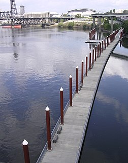
WThe Eastbank Esplanade is a pedestrian and bicycle path along the east shore of the Willamette River in Portland, Oregon, United States. Running through the Kerns, Buckman, and Hosford-Abernethy neighborhoods, it was conceived as an urban renewal project to rebuild the Interstate 5 bicycle bypass washed out by the Willamette Valley Flood of 1996. It was renamed for former Portland mayor Vera Katz in November 2004 and features a statue of her near the Hawthorne Bridge.
Human Access Project is an organization based in Portland, Oregon, working to improve access to and public perception of the Willamette River.
 W
WThe Kevin J. Duckworth Memorial Dock is a dock on the Willamette River, along Portland, Oregon's Eastbank Esplanade. The dock has served as a memorial to Kevin Duckworth since 2009. In 2016, the Oregon State Marine Board considered relocating the dock to Swan Island. The Human Access Project proposed additional improvements to the dock in 2017.
 W
WLake Allison was a temporary lake in the Willamette Valley of Oregon, formed periodically by the Missoula Floods from 15,000 to 13,000 BC. The lake is the main cause of the rich and fertile soil that now characterizes the Willamette Valley.
WThe Little Willamette River is a minor tributary of the Willamette River in Linn County in the U.S. state of Oregon. It begins in a gravel pit slightly east of the main stem in a bend of the larger river west of Albany. Flowing generally northeast and roughly parallel to the main stem for about 3 miles (5 km), it enters the Willamette about 121.5 miles (195.5 km) from the larger river's mouth on the Columbia River.
 W
WThe Multnomah Channel is a 21.5-mile (34.6 km) distributary of the Willamette River. It diverges from the main stem a few miles upstream of the main stem's confluence with the Columbia River in Multnomah County in the U.S. state of Oregon. The channel flows northwest then north around Sauvie Island to meet the Columbia River near the city of St. Helens, in Columbia County.
 W
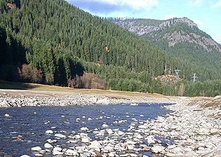
WThe North Fork Middle Fork Willamette River as it is officially named but frequently called North Fork of the Willamette River or North Fork of the Middle Fork of the Willamette River has its headwaters at Waldo Lake and flows into the Middle Fork Willamette River northwest of Oakridge. In the first 3 miles (5 km) below Waldo Lake, the river drops 2,400 feet (730 m) in 34 separate waterfalls through diverse natural plant life and old growth forest.
 W
WOaks Park is a small amusement park located 3.5 miles (5.6 km) south of downtown Portland, Oregon, United States. The park opened in May 1905 and is one of the oldest continually operating amusement parks in the country.
 W
WThe Oregon Museum of Science and Industry is a science and technology museum in Portland, Oregon, United States. It contains three auditoriums, including a large-screen theatre, planetarium, and exhibition halls with a variety of hands-on permanent exhibits focused on natural sciences, industry, and technology. Transient exhibits span a wider range of disciplines.
 W
WOswego Lake is a lake in Clackamas County, Oregon that is completely surrounded by the city of Lake Oswego. Though the lake is naturally occurring, it has been significantly altered because of the concrete dam that has increased its size to 431.7 acres (1.747 km2). The United States Geological Survey records the official name as Lake Oswego and, because of its artificially increased size, classifies it as a reservoir. To distinguish it from the city, however, the lake is usually called Oswego Lake.
 W
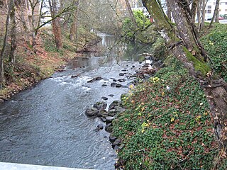
WShelton Ditch is an artificial canal in Marion County, Oregon, United States. Built in the mid-19th century, it originates from Mill Creek east of Airport Road in Salem, passes through a corner of the Salem main Post Office property, and along the southern edge of downtown Salem. Shelton Ditch passes by the north side of Pringle Park before emptying into Pringle Creek. After the Mill Race joins Pringle Creek near Salem's city hall, Pringle Creek passes under the Boise Cascade building and empties into the Willamette River next to Riverfront Park across from Minto-Brown Island Park.
 W
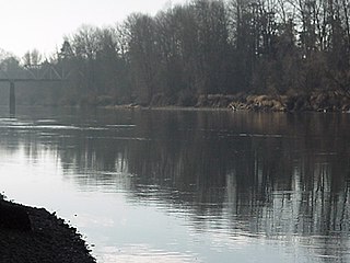
WThe Willamette River flows northwards down the Willamette Valley until it meets the Columbia River at a point 101 miles from the Pacific Ocean, in the U.S. state of Oregon.
 W
WGovernor Tom McCall Waterfront Park is a 36.59-acre (148,100 m2) park located in downtown Portland, Oregon, along the Willamette River. After the 1974 removal of Harbor Drive, a major milestone in the freeway removal movement, the park was opened to the public in 1978. The park covers 13 tax lots and is owned by the City of Portland. The park was renamed in 1984 to honor Tom McCall, the Oregon governor who pledged his support for the beautification of the west bank of the Willamette River—harkening back to the City Beautiful plans at the turn of the century which envisioned parks and greenways along the river. The park is bordered by RiverPlace to the south, the Steel Bridge to the north, Naito Parkway to the west, and Willamette River to the east. In October 2012, Waterfront Park was voted one of America's ten greatest public spaces by the American Planning Association.
 W
WWiley's Seaplane Port is a seaplane base on the Willamette River in Lake Oswego, Oregon, within the Portland metropolitan area. It was activated in March 1979, and run by Dave Wiley for nearly 30 years.
 W
WThe Willamette Falls is a natural waterfall on the Willamette River between Oregon City and West Linn, Oregon, in the United States. It is the largest waterfall in the Northwestern United States by volume, and the seventeenth widest in the world. Horseshoe in shape, it is 1,500 feet (460 m) wide and 40 feet (12 m) high with a flow of 30,849 cu ft/s, located 26 miles (42 km) upriver from the Willamette's mouth.
 W
WThe Willamette Falls Locks are a lock system on the Willamette River in the U.S. state of Oregon. Opened in 1873 and closed since 2011, they allowed boat traffic on the Willamette to navigate beyond Willamette Falls and the T.W. Sullivan Dam. Since their closure in 2011 the locks are classified to be in a "non-operational status" and are expected to remain permanently closed.
 W
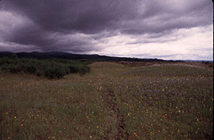
WThe Willamette Floodplain consists of 713 acres (289 ha) of natural grassland, near the Willamette River, that was made a National Natural Landmark in May 1987. The floodplain is within the William L. Finley National Wildlife Refuge and located about 10 miles (16 km) south of Corvallis in Benton County, Oregon.
 W
WThe Willamette River Greenway is a cooperative state and local government effort to maintain and enhance the scenic, recreational, historic, natural and agricultural qualities of the Willamette River and its adjacent lands. A number of trails exist along the greenway, but significant gaps still exist.
 W
WThe Willamette National Forest is a National Forest located in the central portion of the Cascade Range of the U.S. state of Oregon. It comprises 1,678,031 acres (6,790.75 km2). Over 380,000 acres are designated wilderness which include seven major mountain peaks. There are also several National Wild and Scenic Rivers within the forest. The forest is named for the Willamette River, which has its headwaters in the forest. The forest headquarters are located in the city of Springfield. There are local ranger district offices in McKenzie Bridge, Detroit, Sweet Home, and Westfir.
 W
WWillamette Riverkeeper is a non profit organization formed in 1996 in order to protect and restore the Willamette River's water quality and habitat.
 W
WThe Willamette Valley is a 150-mile (240 km) long valley in Oregon, in the Pacific Northwest region of the United States. The Willamette River flows the entire length of the valley, and it is surrounded by mountains on three sides – the Cascade Range to the east, the Oregon Coast Range to the west, and the Calapooya Mountains to the south.
 W
WThe Willamette Valley flood of 1996 was part of a larger series of floods in the Pacific Northwest of the United States which took place between late January and mid-February 1996. It was Oregon's largest flood event in terms of fatalities and monetary damage during the 1990s. The floods spread beyond Oregon's Willamette Valley, extending west to the Oregon Coast and east toward the Cascade Mountains. Significant flood damage also impacted the American states of Washington, Idaho and California. The floods were directly responsible for eight deaths in Oregon, as well as over US$500 million in property damage throughout the Pacific Northwest. Three thousand residents were displaced from their homes.