 W
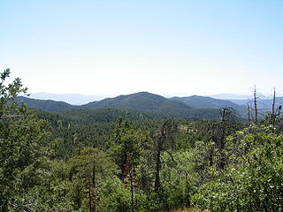
WThe Prescott National Forest is a 1.25 million-acre United States National Forest located in north central Arizona in the vicinity of Prescott. The forest is located in the mountains southwest of Flagstaff and north of Phoenix in Yavapai County, with a small portion extending into southwestern Coconino County.
 W
WApache Creek Wilderness is a 5,666-acre wilderness area under the jurisdiction of the Chino Valley District of the Prescott National Forest in the U.S. state of Arizona. Established in 1984, the Wilderness contains rolling hills of juniper and pinyon pine, outcroppings of granite, three natural springs, and several important riparian areas including Apache Creek. Elevations range from 5,280 feet to 6,970 feet, and the area provides excellent habitat for mountain lion and numerous bird species.
 W
WThe Black Hills of Yavapai County are a large mountain range of central Arizona in southeast Yavapai County. It is bordered by the Verde Valley to the east. The northwest section of the range is bisected from the southeast section by Interstate 17, which is the main route connecting Phoenix to Sedona, Oak Creek Canyon, and Flagstaff. This bisection point is the approximate center of the mostly northwest by southeast trending range. The northwest section contains a steep escarpment on the northeast with the Verde Valley, the escarpment being the location of the fault-block that created the historic mining district at Jerome. The United Verde Mine was one of the largest copper mines in the United States, producing large quantities of copper, gold, silver and zinc.
 W
WThe Bradshaw Mountains are a mountain range in central Arizona, United States, named for brothers Isaac and William D. Bradshaw after their deaths, having been formerly known in English as the Silver Mountain Range.
WCastle Creek Wilderness is a protected wilderness area in the Prescott National Forest in the U.S. state of Arizona. Established in 1984, the Wilderness lies within the southern end of the rugged Bradshaw Mountains. Elevations range from 2,800 feet to 7000 feet, allowing for a range of vegetation. Saguaro cactus, palo verde, and mesquite dominate the lower end of the range in the south, as the elevation increases the vegetation changes to a chaparral community and further north in the highest elevations includes ponderosa pine, Arizona oak, and alligator juniper.
WCedar Bench Wilderness is a protected wilderness area in the Prescott National Forest in the U.S. state of Arizona. Established in 1984 under the Arizona Wilderness Act, the area protects the large "bench" that divides the Agua Fria and Verde River drainages. Elevations range from 4,500 feet to 6,700 feet with vegetation that includes saguaro cactus along the Verde river to chaparral to smaller amounts of pinyon pine and Utah juniper along the high points.
 W
WThe Chino Valley of Arizona is a large, 70-mi (113 km) long valley, centered on Seligman, Arizona in northwest Yavapai County and southwest Coconino County. The valley is located at the southwest of the Coconino Plateau and lies in the extreme northwest of Arizona's transition zone.
 W
WGoldwater Lake is a reservoir formed by a dam on Bannon Creek, located south of Prescott in North Central Arizona. This lake is maintained by the City of Prescott Parks and Recreation department. The park has facilities for picnicking, fishing, boating, hiking, volleyball, and horseshoes.
WGranite Basin Lake is a reservoir located near Prescott, in Yavapai County, North Central Arizona. It is in the Prescott National Forest, adjacent to the Granite Mountain Wilderness Area.
 W
WGranite Mountain is a 7,628-foot (2,325 m) mountain located in Yavapai County, Arizona that covers roughly 12 square miles (31 km2). It was once known as Mount Gurley, for the first governor of the Arizona Territory, John A. Gurley. Its southwest face has a sheer granite cliff approximately 500 feet high that is one of the best locations for rock climbing in the state of Arizona. It is located in the Granite Mountain Wilderness, which is managed as a part of the Prescott National Forest. The mountain stands at the northern end of the Sierra Prietas, and borders Skull Valley on the west, on the northwest by the Santa Maria Mountains, and east by the Williamson Valley.
 W
WThe Hassayampa River is an intermittent river, the headwaters of which are just south of Prescott, Arizona, and flows mostly south towards Wickenburg, entering the Gila River near Hassayampa. Although the river has only subsurface flow for much of the year, it has significant perennial flows above ground within the Hassayampa River Canyon Wilderness and the Nature Conservancy's Hassayampa River Preserve, near Wickenburg. The river is about 113 miles (182 km) long, with a watershed of 1,410 square miles (3,700 km2), most of it desert.
WHorsethief Basin Lake is a reservoir in the Bradshaw Mountains and the Prescott National Forest, in central Arizona. It is located near Crown King in eastern Yavapai County. Fish species present include Bluegill, Largemouth Bass, Channel Catfish, and Muskie.
 W
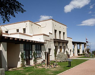
WJerome State Historic Park is a state park of Arizona, US, featuring the Douglas Mansion, built in 1916 by a family of influential mining entrepreneurs in Jerome, Arizona, a mining region in the northeast of the Black Hills, east Yavapai County. A museum is located in the old Douglas Mansion.
WJuniper Mesa Wilderness is a 7,406-acre wilderness area in the Prescott National Forest in the U.S. state of Arizona. The mesa is about an hour's drive northwest of Prescott in the Juniper Mountains of Yavapai County. The wilderness varies in elevation from 5,600 to 7,000 feet. It is entirely within the Juniper Mountain quadrangle of the United States Geological Survey (USGS) topographic map.
 W
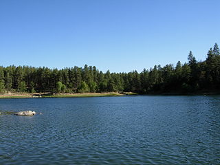
WLynx Lake, Arizona, is a 55-acre (220,000 m2) reservoir located within Prescott National Forest, approximately 5 miles (8.0 km) east of Prescott, Arizona, in the Bradshaw Mountains. The lake is located at 5,530 feet (1,690 m) elevation and is stocked for fishing. It is one of the most popular recreation areas in central Arizona. Mild weather, the cool ponderosa pine forest, trout fishing, boating, mountain hiking, horseback riding, archaeological sites, and bird watching attract visitors from throughout Arizona. The lake was formed in 1952, when a dam was put in Lynx Creek, 6 miles (9.7 km) below Walker, Arizona.
WMingus Mountain is a mountain located in the U.S. state of Arizona in the Black Hills mountain range. It is located within the Prescott National Forest traversed by State Route 89A approximately midway between Cottonwood and Prescott. The summit can be reached via Forest Service roads that branch off from State Route 89A. From the mountain, there are views of the Verde Valley, Sycamore Canyon Wilderness and the towns of Cottonwood, Jerome, and Clarkdale. The Woodchute Wilderness, north of the summit of 89A, also offers views and hiking trails. There are several National Forest campgrounds in the area and it is the transmitter location for Prescott full-service television station KAZT-TV and several low-power television stations serving Cottonwood, Clarkdale, Camp Verde and Prescott Valley. Mingus Mountain is also the premier flying site of the Arizona Hang Gliding and Paragliding Association.
WPine Mountain Wilderness is a protected wilderness area managed by the Prescott National Forest in the U.S. state of Arizona. Pine Mountain is the high point of the Verde River Rim at 6,814 feet and provides an excellent viewing to the northeast of the Wild and Scenic Verde while surrounded by ponderosa pine and Douglas fir.
WThe Santa Maria Mountains are a 16-mi (26 km) long mountain range in central-northwest Arizona, and in northwest Yavapai County. The range lies in a region of mesas and mountain ranges in the northwest of Arizona's transition zone. The Santa Maria Mountains lie east of the transition zone's northwest perimeter, the parallel Aquarius and Mohon Mountains.
 W
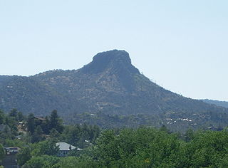
WThe Sierra Prieta is a 14-mi (23 km), long mountain range in central-northwest Arizona. The range is the mountainous region west of Prescott, with prominent Thumb Butte, 6,514 feet (1,985 m), a volcanic plug, on the city's west perimeter.
 W
WSycamore Canyon is the second largest canyon in the Arizona redrock country, after Oak Creek Canyon. The 21-mile (34 km) long scenic canyon reaches a maximum width of about 7 miles (11 km). It is in North Central Arizona bordering and below the Mogollon Rim, and is located west and northwest of Sedona in Yavapai and Coconino counties.
WSycamore Canyon Wilderness is a 56,000-acre wilderness area in the Coconino, Kaibab and Prescott national forests in the U.S. state of Arizona. Encompassing Sycamore Canyon and its surrounds from south of Williams to the confluence of Sycamore Creek with the Verde River, the wilderness is about 40 miles southwest of Flagstaff. The canyon is one of several in Arizona that cut through the Mogollon Rim. Relevant United States Geological Survey (USGS) map quadrangles are Davenport Hill, White Horse Lake, May Tank Pocket, Perkinsville, Sycamore Basin, and Clarkdale. Red Rock-Secret Mountain Wilderness borders Sycamore Canyon Wilderness on the east.
WMount Union is a mountain located in the Prescott National Forest in central Yavapai County, Arizona. The mountain's summit is the highest point of the Bradshaw Mountains, and of Yavapai County. Mount Union is flanked to the northeast by Mount Davis. A lookout tower built by the CCC is on top of Mount Union, and exceeds 8,000 foot elevation. A service road for the communication towers allows easy access to the summit of Mount Union.
 W
WThe Verde Canyon Railroad is a heritage railroad running between Clarkdale and Perkinsville in the U.S. state of Arizona. The passenger excursion line operates on 20 miles (32 km) of tracks of the Clarkdale Arizona Central Railroad (AZCR), a shortline. The Verde Canyon Railroad has its depot, headquarters, and a railway museum in Clarkdale, about 25 miles (40 km) southwest of Sedona.
 W
WThe Verde River is a major tributary of the Salt River in the U.S. state of Arizona. It is about 170 miles (270 km) long and carries a mean flow of 602 cubic feet per second (17.0 m3/s) at its mouth. It is one of the largest perennial streams in Arizona.
 W
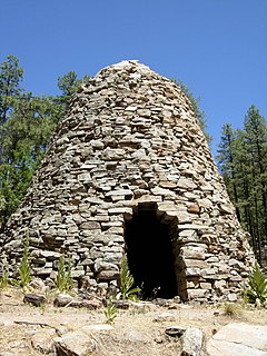
WThe Walker Charcoal Kiln is a structure in the Prescott National Forest near the town of Walker, Arizona and situated in the vicinity of the abandoned Poland Junction Mine near the summit of Renegade Hill. It is listed on the National Register of Historic Places. A sign posted near the kiln reads, "This kiln was constructed around 1880 by Jake and Joe Carmichael to convert oak wood into charcoal for use at nearby smelters. The surrounding forest was cut so heavily for charcoal and mine props in the late 1800s that it is just now becoming productive again." Locally, the kiln is referred to as "the Beehive".
 W
WWoodchute Wilderness is a 5,923-acre wilderness area in Prescott National Forest in the U.S. state of Arizona. It is about 4 miles west of the town of Jerome. Elevation within the area, on the flanks of Woodchute Mountain, ranges from 5,500 feet to 7,800 feet. A chute on the north side of the mountain helped transport wood to historic Jerome.