 W
WAlbania has more than 152 rivers and streams, forming 8 large rivers flowing from southeast to northwest, mainly discharging towards the Adriatic coast. The rivers of Albania have a total annual flow rate of 1,308 m3/s (46,200 cu ft/s), or 41.25 km3 (9.90 cu mi) per year.
 W
WBistricë is a river in southwestern Albania. It ends in the Ionian Sea.
 W
WThe Black Drin, or Black Drim is a river in North Macedonia and Albania. It flows out of Lake Ohrid in Struga, North Macedonia. It is 149 km (93 mi) long and its drainage basin is 3,504 km2 (1,353 sq mi). Its average discharge is 118 m3/s (4,200 cu ft/s). After about 56 km (35 mi) it crosses the border to Albania, west of Debar, North Macedonia. It merges with the White Drin in Kukës to form the Drin, which flows into the Adriatic Sea. It drains most of the eastern border region of Albania. The name is ancient - Drinius, Trinius (Pliny), Δρεῖνος (Ptolemy). Its origin is Illyrian from older *Drūn, from Indo-European *drū- into Old Indian drāvayate, run, flow, Avestan dru, run.
 W
WBojana is a 41-kilometre-long (25 mi) river in Albania and Montenegro which flows into the Adriatic Sea. An outflow of Lake Skadar, measured from the source of the lake's longest tributary, the Morača, the Morača-Lake Skadar- Bojana system is 183 km (114 mi) long.
 W
WThe Cem, also known as the Cijevna, is a river that rises in Kelmend, Albania and, after nearly half of its length, crosses into Montenegro, where it flows into the River Morača near the capital, Podgorica.
 W
WDevoll is a river in southern Albania. It is one of the source rivers of Seman. It is 196 km (122 mi) long and its drainage basin is 3,130 km2 (1,210 sq mi). Its average discharge is 49.5 m3/s (1,750 cu ft/s). Its source is in the southwestern corner of the Devoll municipality, close to the Greek border. It flows initially northeast, through Miras, then north through Bilisht, and northwest through Progër, Pojan, Maliq, Moglicë, Kodovjat, Gramsh, where it is stowed in a big lake and Gostimë, where it turns south. It joins the Osum near Kuçovë, to form the Seman. The Seman opens into a small delta south of the Karavasta lagoon in the Adriatic sea.
 W
WThe Drin is a river in Southern and Southeastern Europe with two distributaries one discharging into the Adriatic Sea and the other one into the Buna River. Its catchment area extends across Albania, Kosovo, Greece, Montenegro and North Macedonia. The river and its tributaries form the Gulf of Drin, an ocean basin that encompasses the northern Albanian Adriatic Sea Coast.
 W
WThe Drino or Drinos is a river in southern Albania and northwestern Greece, tributary of the Vjosë. Its source is in the northwestern part of the Ioannina regional unit, near the village Delvinaki. It flows initially southwest, then northwest and crosses the Albanian border near Ktismata. It continues northwest through Gjirokastër and flows into the Vjosë near Tepelenë.
 W
WThe Erzen is a river in central Albania. The length of Erzen is 109 km (68 mi), while the catchment area is 760 km2 (290 sq mi) including the southern Tirana District and eastern Durrës District.
 W
WThe Fan is a river in northern Albania. It is formed by the confluence of two source rivers: the Great Fan and the Little Fan, that join a few kilometers west of the town Rrëshen.
 W
WThe Gashi is a 27-kilometre-long (17 mi) river located in Tropojë, northern Albania. It is a nature reserve, spanning an area of 3,000 ha. The nature reserve forms a part of the European Green Belt and has been declared a UNESCO World Heritage Site within the Primeval Beech Forests of the Carpathians and Other Regions of Europe.
 W
WThe Ishëm is a river in western Albania, which brings water to the area north of the Albanian capital, Tirana. It forms part of a watercourse (Tiranë-Gjole-Ishëm), but only the lower third of the watercourse is known as the Ishëm. The Ishëm proper is formed at the confluence of the rivers Gjole and Zezë, a few km northwest of Fushë-Krujë. It flows into the Adriatic Sea near the town Ishëm. The length of the watercourse is recorded in different sources as between 74 and 79 km.
 W
WThe Kir is a river in northern Albania that first flows south-southwest and then southwest out of the North Albanian Alps and enters a distributary of the Drin just below Shkodër.
 W
WThe Lanë is the main stream that crosses through Tirana, the capital of Albania. Its source is in the mountains east of Tirana. Although once clean, it now carries sewage. During the 1990s, many illegal kiosks and buildings were constructed on the banks of the river. They were later torn down and removed in a campaign by Tirana's then mayor Edi Rama in the early 2000s. Now most of its banks have been planted with different kinds of trees and grass. No fish live there now due to the high pollution of its waters. The Lanë flows into the Tiranë River near Bërxullë.
 W
WThe Mat is a river in north-central Albania. Its overall length is 115 km (71 mi), while its catchment surface is 2,441 km2 (942 sq mi). Its average discharge is 103 m3/s (3,600 cu ft/s). The main tributary is Fan, flowing from the northeast, while the Mat flows from the southwest down to the confluence with Fan and then towards the Adriatic Sea.
 W
WThe Osum is a river in southern Albania, one of the source rivers of the Seman. It is 161 km (100 mi) long and its drainage basin is 2,073 km2 (800 sq mi). Its average discharge is 32.5 m3/s (1,150 cu ft/s). Its source is in the southwestern part of the Korçë County, near the village Vithkuq at an altitude of 1,050 metres (3,440 ft). It flows initially south to the Kolonjë municipality, then west to Çepan, and northwest through Çorovodë where it flows through the famous Osum Canyon, Poliçan, Berat and Urë Vajgurore. It joins the Devoll near Kuçovë, to form the Seman. The discharge of the river is reported to vary between 5.11 m3 (180 cu ft)/s and 74.11 m3 (2,617 cu ft)/s.
 W
WThe Pavllë is a river in northwestern Greece and southern Albania. Its source is in the Mourgana mountains in Greece, near the village Ampelonas, Thesprotia. It flows west into Albania, along the villages Vagalat and Shkallë. It flows into the Ionian Sea a few kilometres southwest of the archaeological site Butrint. There is a bridge across the river near the village Ampelonas, built in 1798.
 W
WThe Sarantaporos is a river in northwestern Greece and southern Albania. It is a right tributary of the river Aoös (Vjosë), which flows into the Adriatic Sea. Its length is 50 km (31 mi), of which the final approx. 10 km (6.2 mi) form the border between Greece and Albania. Its source is between the mountain ranges Gramos and Voio, in the Kastoria regional unit. It flows through the municipal units Arrenes, Mastorochoria and Konitsa in Greece, and the municipalities Qendër Leskovik and Çarshovë in Albania. Its basin area is 870 km2 (340 sq mi), and its year-average discharge is 6.93 m3 (245 cu ft) per second.
 W
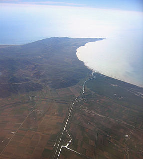
WThe Seman is a major river in western Albania. It is formed by the confluence of the rivers Devoll and Osum, a few km west of Kuçovë. It is 85 km (53 mi) long and its drainage basin is 5,649 km2 (2,181 sq mi). Its average discharge is 95.7 m3/s (3,380 cu ft/s). It meanders generally westwards through a flat lowland. Near Fier it receives Gjanica from the left. It flows into the Adriatic Sea at the southern margin of the Divjakë-Karavasta National Park.
 W
WThe Shalë is a river flowing inside the Albanian Alps in northern Albania. Its source is in the Albanian Alps, near the village Theth, close to the border with Montenegro. The Shalë flows generally south through the municipal units Shalë, Shosh and Temal. It flows into the Koman Reservoir, fed and drained by the river Drin, near the village Telum.
 W
WThe Shkumbin, also commonly Shkembi, is a river in Southern Europe. It is 181 km (112 mi) long and its drainage basin is 2,444 km2 (944 sq mi). Its average discharge is 61.5 m3/s (2,170 cu ft/s).
 W
WThe Shushicë or Vlora river is a river in southern Albania, tributary of the Vjosë. Its source is in the Vlorë County, near the village Kuç, municipality Himarë. It flows generally northwest through Brataj, Kotë and Shushicë and flows into the Vjosë near Armen, northeast of Vlorë.
 W
WThe Tomorrica is a river in southeastern Albania. River Tomorrica is a left tributary of Devoll, which feeds the Adriatic Sea in southeastern Albania. The river, 42 kilometers long, originates in the Tomorr Mountains, on the southern slopes of Mount Mieta. At 1800 meters above sea level. Its catchment area is 376 km², collecting the waters of the Tomorr Mountains in the west and the Ostrovicë Mountains in the east. Significant left tributaries are only found on the lower reaches of the river: Velica, Leshnica, Kushova and Bregas.
 W
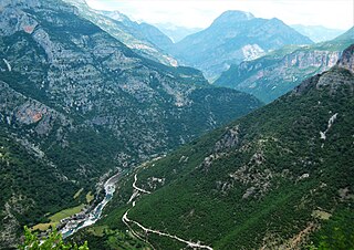
WThe Valbona is a river in northern Albania. It is still relatively untouched. Its source is in the Prokletije, near the border with Montenegro.
 W
WThe Aoös or Vjosë is a river in northwestern Greece and southwestern Albania. Its total length is about 272 kilometres (169 mi), of which the first 80 kilometres (50 mi) are in Greece, and the remaining 192 kilometres (119 mi) are in Albania. Its drainage basin is 6,706 km2 (2,589 sq mi) and its average discharge is 195 m3/s (6,900 cu ft/s). It is fed by several tributaries, such as the Voidomatis, Sarantaporos, Drino and Shushicë.
 W
WThe White Drin or White Drim is a river in Kosovo and northern Albania, a ca. 140-kilometre (87 mi)-long headstream of the Drin.