 W
WThe San Rafael Hills are a mountain range in Los Angeles County, California. They are one of the lower Transverse Ranges, and are parallel to and below the San Gabriel Mountains, adjacent to the San Gabriel Valley overlooking the Los Angeles Basin.
 W
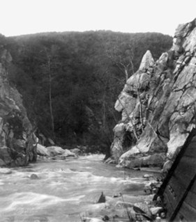
WThe Arroyo Seco, meaning "dry stream" in Spanish, is a 24.9-mile-long (40.1 km) seasonal river, canyon, watershed, and cultural area in Los Angeles County, California. The area was explored by Gaspar de Portolà who named the stream Arroyo Seco as this canyon had the least water of any they had seen. During this exploration he met the Chief Hahamog-na (Hahamonga) of the Tongva Indians.
 W
WThe Arroyo Seco Parkway, also known as the Pasadena Freeway, is the first freeway built in the United States. It connects Los Angeles with Pasadena alongside the Arroyo Seco seasonal river. It is notable not only for being the first, mostly opened in 1940, but for representing the transitional phase between early parkways and modern freeways. It conformed to modern standards when it was built, but is now regarded as a narrow, outdated roadway. A 1953 extension brought the south end to the Four Level Interchange in downtown Los Angeles and a connection with the rest of the freeway system.
 W
WCalifornia's 24th State Senate district is one of 40 California State Senate districts. It is currently represented by Democrat Maria Elena Durazo of Los Angeles.
 W
WCalifornia's 25th State Senate district is one of 40 California State Senate districts. It is currently represented by Democrat Anthony Portantino of La Cañada Flintridge.
 W
WCity Terrace is an unincorporated community in Los Angeles County, California. The County administers City Terrace as an unincorporated area, together with Belvedere and Eastmont.
 W
WThe Crescenta Valley is a small inland valley in Los Angeles County, California, lying between the San Gabriel Mountains on the northeast and the Verdugo Mountains and San Rafael Hills on the southwest. It opens into the San Fernando Valley at the northwest and the San Gabriel Valley at the southeast. It is nearly bisected by the Verdugo Wash, a smaller valley separating the Verdugo Mountains from the San Rafael Hills. Most of the valley lies at an elevation of over 1,500 feet.
 W
WCypress Park is a densely populated neighborhood of 10,000+ residents in Northeast Los Angeles, California. Surrounded by hills on three sides, it sits in the valley created by the Los Angeles River and the Arroyo Seco. It is the site of the Rio de Los Angeles State Park, the Los Angeles River Bike Path and other recreational facilities. It hosts one private and four public schools.
 W
WEagle Rock is a neighborhood of Northeast Los Angeles, located between the cities of Glendale and Pasadena, abutting the San Rafael Hills in Los Angeles County, California. Eagle Rock is named after a large rock whose shadow resembles an eagle with its wings outstretched. Eagle Rock was once part of the Rancho San Rafael under Spanish and Mexican governorship. In 1911, Eagle Rock was incorporated as a city, and in 1923 it combined with the City of Los Angeles.
 W
WEl Sereno is a Los Angeles neighborhood in the Eastside Los Angeles region of Los Angeles County, California.
 W
WErnest E. Debs Regional Park is a large open space nature reserve and regional park in the Montecito Hills neighborhood of central-northeast Los Angeles, California.
 W
WGlendale is a city in Los Angeles County, California, in the San Fernando Valley. As of the 2010 census it had a population of 191,719, and in 2019 the population was estimated at 204,765, making it the fourth-largest city in Los Angeles County and the 23rd-largest city in California. It is located about 10 miles (16 km) north of downtown Los Angeles.
 W
WHighland Park is a historic neighborhood in northeast Los Angeles, California. It was one of the first subdivisions of Los Angeles, and is inhabited by a variety of ethnic and socioeconomic groups.
 W
WLa Cañada Flintridge is a city in Los Angeles County, California, with a population of 20,246 in 2010. It is located in the Crescenta Valley and far western end of the San Gabriel Valley, to the northwest of Pasadena, and is part of the Los Angeles metropolitan area. It is the home of NASA's Jet Propulsion Laboratory.
 W
WLa Crescenta-Montrose is an unincorporated area in Los Angeles County, California. The community is bordered by Glendale to the south and west, La Cañada Flintridge to the east, and Angeles National Forest to the north. According to the United States Census Bureau, the La Crescenta-Montrose CDP measures about 3.4 square miles (8.8 km2), and the population was 19,653 at the 2010 census, up from 18,532 in the 2000 census.
 W
WThe Langham Huntington, Pasadena is a resort hotel located in Pasadena, California, that dates back to the Gilded Age.
 W
WMontecito Heights is a small district in Northeast Los Angeles. The population in 2000 was estimated at 16,768.
WMonterey Hills is a small, diverse, middle-class community within the city of Los Angeles, California located about 4 miles ENE of Downtown Los Angeles and about 3 miles from Pasadena off the 110 Freeway. It is surrounded by El Sereno to the southeast, Hermon to the north, Montecito Heights to the southwest and the independent city of South Pasadena to the northeast. Monterey Hills is part of the Arroyo Seco Neighborhood Council (ASNC).
 W
WMount Washington is a historic neighborhood in the San Rafael Hills of Northeast Los Angeles, California. Founded in 1909, it includes the Southwest Museum, the world headquarters of the Self-Realization Fellowship, and Eldred Street, one of the three steepest streets in Los Angeles.
 W
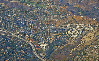
WOccidental College is a private liberal arts college in Los Angeles, California. Founded in 1887 as a coeducational college by clergy and members of the Presbyterian Church, it became non-sectarian in 1910. It is one of the oldest liberal arts colleges on the West Coast of the United States.
 W
WThe Poppy Peak Historic District is a neighborhood and historic district located in the southwest corner of Pasadena, California. The neighborhood is located on the side of Poppy Peak, a 991-foot-high (302 m) mountain of the San Rafael Hills. Developer William Carr platted the neighborhood in 1924. The homes in the district were designed by a number of significant Modern Movement architects. The district was added to the National Register of Historic Places in 2009.
 W
WSan Marino is a residential city in Los Angeles County, California, United States. It was incorporated on April 25, 1913. As of the 2010 census the population was 13,147.
 W
WThe Scholl Canyon Landfill is a municipal solid waste disposal facility and landfill located in the central San Rafael Hills, within eastern Glendale in Los Angeles County, southern California. The 314 acres of land is located at 3001 Scholl Canyon Road, north of the Ventura Freeway, east of the Glendale Freeway, north of Eagle Rock, and west of the Arroyo Seco. It is owned by the City of Glendale. The landfill opened in 1961.
 W
WSouth Pasadena is a city in Los Angeles County, California, United States. As of the 2010 census, it had a population of 25,619, up from 24,292 at the 2000 census. It is located in the West San Gabriel Valley. It is 3.42 square miles in area and lies between the much larger city of Pasadena, of which it was once a part, and the metropolis of Los Angeles. South Pasadena is the oldest self-builder of floats in the historic Tournament of Roses Parade.
 W
WVerdugo Wash is a 9.4-mile-long (15.1 km) tributary of the Los Angeles River, in the Glendale area of Los Angeles County, California.
 W
WThe Whittier Narrows is a narrows or water gap in California, United States, between the Puente Hills to the east and the Montebello Hills to the west. The gap is located at the southern boundary of the San Gabriel Valley, through which the Rio Hondo and the San Gabriel River flow through to enter the Los Angeles Basin. The gap is also traversed by both Interstate 605 and California State Route 19.