 W
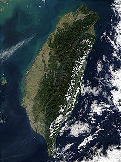
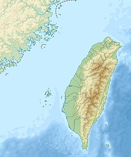
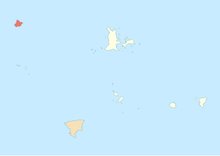
WTaiwan, officially the Republic of China (ROC), is an island country in East Asia. The main island of Taiwan, known historically in English as Formosa, makes up 99% of the area controlled by the ROC, measuring 35,808 square kilometres (13,826 sq mi) and lying some 180 kilometres (112 mi) across the Taiwan Strait from the southeastern coast of mainland China. The East China Sea lies to its north, the Philippine Sea to its east, the Luzon Strait directly to its south and the South China Sea to its southwest. Smaller islands include a number in the Taiwan Strait including the Penghu archipelago, the Kinmen and Matsu Islands near the Chinese coast, and some of the South China Sea Islands.
 W
WDongji Island / Dongji Islet / Tungchi Island is an island in Dongji Village (東吉村), Wangan Township, Penghu County, Taiwan. Dongji Island has also been known as Nandongyu (南東嶼).
 W
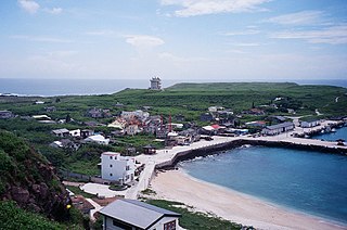
WGreen Island, also known by other names, is a small volcanic island in the Pacific Ocean about 33 km (21 mi) off the eastern coast of Taiwan. It is 15.092 km2 (5.83 sq mi) at high tide and 17.329 km2 (6.69 sq mi) at low tide, making it the Republic of China's seventh-largest island. The island is administered as Lüdao Township, a rural township of Taitung County and one of the county's two offshore areas. The island once served as a penal colony for political prisoners during Taiwan's period of martial law, although today it is primarily known as a tourist hotspot.
 W
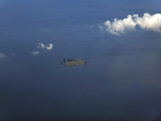
WGuishan Island / Gueishan Island or Steep Island or Turtle Island, also known as Kweishan Island or Kweishan Tao, is an island in the Pacific Ocean, part of Toucheng Township, Yilan County, Taiwan and located 9.1 km (5.7 mi) east of port of Kengfang Fishery Harbor. The island's name is derived from the resemblance of the topography of the island to that of a turtle. There is a smaller island south of Gueishan Island called Gueiluan Island). The island is a dormant volcano that last erupted on 1785.
 W
WGupo Island, also transliterated as Koba Island, is an island in Baisha Township, Penghu County, Taiwan.
 W
WHua Islet is an islet in Huayu Village (花嶼村), Wangan Township, Penghu County, Taiwan. Hua Islet is the westernmost point in Penghu. The island has also been known as "West Islet" (西嶼). The Japanese-built Huayu Lighthouse is located on the southwestern hill of the island.
 W
WHuaping Islet, Taiwanese Hokkien: is an 0.0308 km2 (0.0119 sq mi) high island in Zhongzheng District, Keelung, Taiwan located in the East China Sea. The islet is 180 m (590 ft) long and 80 m (260 ft) wide with an elevation of 51 m (167 ft). 'Pyroxene and andesite are the major rock types of the islet. The entire islet is covered with metallic volcanic debris which has turned purplish red (bordeaux), purple, green, brass (yellowish) and iron grey after oxidation.' Along with the nearby Pengjia Islet and Mianhua Islet, Huaping Islet is considered of strategic importance to Taiwan.
 W
WHujing Island / Huching Island / Hujing Islet (Chinese: 虎井嶼; pinyin: Hǔjǐng Yǔ; Wade–Giles: Hu3-ching3 Yü3; Pe̍h-ōe-jī: Hó͘-chéⁿ-sū) is an islet in Hujing Village (虎井里), Magong City, Penghu County (the Pescadores), Taiwan. The island has also been known as Da'anshan (大案山) and the nearby Tongpan Island as Xiao'anshan (小案山). The southern part of the island is crossed by the Tropic of Cancer. Hujing Island is the seventh largest island in Penghu (the Pescadores). The island is 7 nmi (13 km) from Penghu Main Island. There are mountains on the eastern end (Dongshan) and western end (Sishan) of the island.
 W
WThe Jiangong Islet is a tidal island in Jincheng Township, Kinmen County, Fujian Province, Republic of China (Taiwan).
 W
WJibei Island is an island in Baisha Township, Penghu County, Taiwan.
 W
WKeelung Islet is a small island in Zhongzheng District, Keelung, Taiwan and 4.9 km (3.0 mi) away from the Port of Keelung. It has an area of 27,005.593 m2 (0.010426918 sq mi) or 23.91 ha. It is 910 m (2,986 ft) in length, and 410 m (1,345 ft) in width including the artificial harbor, the highest point is 182 m (597 ft) above sea level.
 W
WKinmen, also Quemoy, is a county of the Republic of China (Taiwan) located in the Taiwan Strait between the island of Taiwan and mainland China. The main island of Kinmen County is Kinmen Island. Kinmen is located ten kilometres (6.2 mi) east of Xiamen, a city located on the southeastern coast of China; the two territories are separated by a small bay. Kinmen is 187 kilometres (116 mi) west from the nearest part of the island of Taiwan.
 W
WLalu Island is a small island in Sun Moon Lake, Yuchi Township, Nantou County, Taiwan. The island used to be much bigger, separating the lake into a part shaped like crescent moon and another part shaped like a round sun. When the island was still bigger, people lived on it; in fact, the locals called it "Pearl Mountain"(Chinese: 珠仔山 or 珠嶼) ever since the Ch'ing dynasty. Under Japanese rule, the island was renamed "Jade Island" , and in the 1930s, the Japanese built a dam that raised the water level in the lake and almost entirely flooded the island. After Chiang Kai-shek's Nationalist Government moved to Taiwan in 1949, the island was renamed Kwanghwa Island. In 1999 the island shrank as portions sank during the 921 earthquake, which also destroyed a wedding pavilion constructed by the local government in 1978.
 W
WLiuqiu, also known by several other names, is a coral island in the Taiwan Strait about 13 kilometers (8 mi) southwest of Taiwan Island. It has an area of 6.8 km2 (2.6 sq mi) and approximately 13,000 residents, the vast majority of whom share only 10 surnames. It is administered as a township of Pingtung County. The current township chief is Chen Lung-chin.
 W
WMianhua Islet is a 0.133 km2 (0.051 sq mi) high island in Zhongzheng District, Keelung, Taiwan, located in the East China Sea. Pingfong Rock, just east of the islet, is the easternmost point under the actual control of Taiwan (ROC).
 W
WMudou Island is an island in Baisha Township, Penghu County, Taiwan, part of the Penghu Islands (Pescadores) archipelago. It is in the Taiwan Strait off the west coast of Taiwan. The island was formed from plateau basalt.
 W
WOrchid Island, also known by other names, is a 45 km2 (17 sq mi) volcanic island off the southeastern coast of Taiwan Island. It is separated from the Batanes of the Philippines by the Bashi Channel of the Luzon Strait. It is governed as Lanyu Township of Taitung County, Taiwan, which also includes the nearby Lesser Orchid Island.
 W
WPengjia Islet, also known as P'eng-chia Hsü, Hōka-sho, Agincourt, Dashihshan Islet, Chaolai Islet, P'eng-chia Yü or Pengchia Islet, is an islet north of Taiwan and is administered under Zhongzheng District, Keelung City. It is under Taiwanese military control and cannot be visited by ordinary citizens.
 W
WPratas Island is an island in the northern part of the South China Sea administered as part of Cijin District, Kaohsiung, Republic of China (Taiwan). It is located about 170 nautical miles southeast of Hong Kong. It has an area of about 240 hectares, including 64 hectares of lagoon, and is the largest of the South China Sea Islands. It is the location of the Dongsha Airport.
 W
WThe Senkaku Islands are a group of uninhabited islands in the East China Sea. They are located east of mainland China, northeast of Taiwan, west of Okinawa Island, and north of the southwestern end of the Ryukyu Islands. They are known in mainland China as the Diaoyu Islands or Diaoyu Dao and its affiliated islands, in Taiwan as the Tiaoyutai Islands / Diaoyutai Islands, and in the Western World are sometimes impartially referred to by the historical name Pinnacle Islands. In Okinawan they are called yukunkubajima. In Yaeyama dialect, they are called iigunkubajima.
 W
WTaiping Island, also known as Itu Aba, and also known by various other names, is the largest of the naturally occurring Spratly Islands in the South China Sea. The island is elliptical in shape being 1.4 kilometres (0.87 mi) in length and 0.4 kilometres (0.25 mi) in width, with an area of 46 hectares. It is located on the northern edge of the Tizard Bank. The runway of the Taiping Island Airport is easily the most prominent feature on the island, running its entire length.
 W
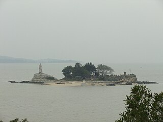
WTongpan Island is an island in Tongpan Village (桶盤里), Magong City, Penghu County, Taiwan. Tongpan Island is about 6 nmi (11 km) from the main island of Penghu. A ferry runs between Tongpan Island and Penghu Main Island twice a day and more often at some times. The island has also been known as Xiao'anshan (小案山).
 W
WThe Turtle Island is an island in Beigan Township, Lienchiang County, Fujian Province, Republic of China (Taiwan).
 W
WThe Twin Candlestick Islets are islets in Jinshan District, New Taipei, Taiwan.
 W
WXianjiao Island is an island in the Penghu Islands archipelago.
 W
WYuanbei Island or Yuanbei Islet, also transliterated as Inkai Island, is an island in Baisha Township, Penghu County, Taiwan.
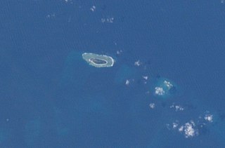
WZhongzhou Reef also known as Ban Than Reef and Centre Cay is a small coral reef on the north edge of the Tizard Bank in the Spratly Islands, South China Sea. It lies 4.6 km (2.9 mi) east of Taiwan-administered Taiping Island, 7.2 km (4.5 mi) west of Vietnam-administered Sand Cay, and has an exposed area of approximately 0.2 hectares during high tide, and 0.6 hectares during low tide. It consists of an accumulation of seashells, sand, coral reefs and debris which forms a circular coral reef plate, surrounding the reef under the water, with a diameter of approximately 1.3 km (0.8 mi).