 W
WAgia Eirini Gorge, sometimes called St. Irene Gorge, is located in the south-west of the island of Crete, Greece, in Lefka Ori. The gorge starts near the village of Agia Eirini and it ends near the village of Sougia, on the south coast. It is 7.5 kilometres (4.7 mi) long and 45–500 metres (148–1,640 ft) deep, in a forested area with steep mountain cliffs. In 1866, 1,000 women and children escaped from the Ottomans through this gorge.
 W
WAgioi Apostoloi is an uninhabited islet to the north of the western coast of Crete in the Aegean Sea. Administratively, it is within the municipality of Chania, in Chania regional unit.
 W
WAgioi Theodoroi are two uninhabited islets off the coast of western Crete. One is named Agios Theodoros, also called Thodorou, and the islet a few metres further north is called Mikros Agios Theodoros. Administratively, they are part of the municipality of Platanias, in Chania regional unit. Kri-kri inhabit Agios Theodoros. Anciently, the islands were known as Coete or Koite and Akytos.
 W
WAgios Nikolaos is an islet with a church on the northern coast of Crete in the Aegean Sea. Administratively, it is located within the municipality of Georgioupoli, in Chania regional unit.
 W
WAkrotiri is a peninsula and former municipality in the Chania regional unit, Crete, Greece. Since the 2011 local government reform it is part of the municipality Chania, of which it is a municipal unit. The municipal unit has an area of 112.644 km2 (43.492 sq mi). Its ancient name was Kiamon while the Byzantines called it Charaka. The seat of Akrotiri municipality was Pythari. Stavros became famous because of the film Zorba the Greek.
 W
WArkoudiotissa is a cave in the municipality of Akrotiri on the Greek island of Crete. From Gouverneto Monastery, the path to the cave is only accessible by foot. Arkoudiotissa ("she-bear"), is noted for its stalagmite which is said to look like a bear. This cave is believed to have been used for worship since ancient times, but was dedicated to the Arkoudiotissa Panaghia during the Christian era. Ascetics lived in the caves in the area.
 W
WArnaouti is an islet on the northern coast of Crete in the Aegean Sea. It is just south of the island of Imeri Gramvousa and is located between Imeri Gramvousa and Valenti rock. Administratively, it is located within the municipality of Kissamos, in Chania regional unit.
 W
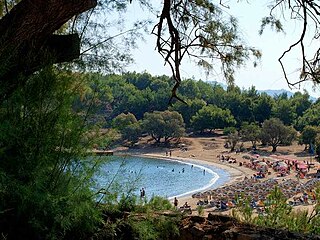
WElafonisi is an island located close to the southwestern corner of the Mediterranean island of Crete, of which it is administratively a part, in the regional unit of Chania. When the weather is fine it is possible to walk to the island through the shallow water. The island is a protected nature reserve. It is known for its pink sand beaches, created by tidal and wave-induced deposits of pigmented microorganisms living in a symbiotic relationship with native seaweed.
 W
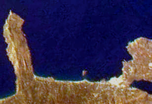
WGavdopoula is an islet located north-west of its larger neighbour, Gavdos, in the Libyan Sea. It is located to the south of Crete, of which it is administratively a part, in the regional unit of Chania. It is part of the municipality of Gavdos, and it was part of the former Selino Province.
 W
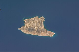
WGavdos is the southernmost Greek island, located to the south of its much larger neighbour, Crete, of which it is administratively a part, in the regional unit of Chania. It forms a community with surrounding islets and was part of the former Selino Province. The island is situated at the southern tip of Greece; it is the southernmost point of Europe.
 W
WGramvousa also Grampousa refers to two small uninhabited islands off the coast of a peninsula also known Gramvousa Peninsula in north-western Crete in the regional unit of Chania. The Gramvousa Peninsula forms the westernmost of the two pairs of peninsulae in north-western Crete and is the western part of Kissamos Bay.
 W
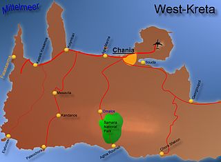
WThe Gulf of Chania is an embayment of the Sea of Crete in the northwestern region of the island of Crete in present-day Greece. One headland forming the Gulf of Chania is the promontory known as the Akrotiri Peninsula.
 W
WKarga, is an uninhabited islet close to the northern coast of Crete in the Aegean Sea. It is located in Souda Bay opposite the islets of Palaiosouda, Souda, and Leon. Administratively, it is within the municipality of Vamos, in Chania regional unit.
 W
WKoursaroi, also known as Nisaki, is an islet close to the western coast of Crete, and north-east of the islet of Praso, in the Aegean Sea. Administratively, it is located within the municipality of Kissamos, in Chania regional unit.
 W
WLazaretta, also called Lazaretto, is an uninhabited island close to the northern coast of Crete in the Aegean Sea. It is located near the city of Chania and administratively, it is within the municipality of Chania, in Chania regional unit.
 W
WLefka Ori or Madares is a mountain range located in Western Crete, in the Chania prefecture. The White Mountains or Lefka Ori occupy a large part of the centre of West Crete and are the main feature of the region. They consist mainly of limestone, from light grey to bluish or black color. The "White Mountains" have got their name from the perpetual white or off white color of their peaks as the off white of limestone during the summer and fall interchanges with the snow that covers the peaks until late in spring.
 W
WLeon, also known colloquially as Nisi and during Venetian rule as Rabbit Island, is an islet in Souda Bay on the northwest coast of Crete.
 W
WLoutro is a rocky islet in the gulf of Loutro on the southwest coast of Crete in the Libyan Sea. The islet can be found close to the end of the Mouri cape. Administratively, it is part of the municipality of Sfakia. The coastal village of Loutro is approximately 71 kilometres south of Chania. The gulf of Loutro was once used for shipbuilding and by merchant ships.
WPalaiosouda, also known as Marathi, is an islet located south of the town of Marathi, close to Souda Bay in Crete. The islet is a popular diving location.
 W
WPetalida, also known as Xera, is an islet close to the northern coast of Crete in the Aegean Sea. It is located between the island of Imeri Gramvousa and the mainland. Administratively, it is located within the municipality of Kissamos, in Chania regional unit.
 W
WPontikonisi is an uninhabited islet off the coast of western Crete. Administratively, it is part of the municipality Kissamos, in Chania regional unit. There is a small islet close to Pontikonisi called Pontikaki.
WPontikaki is an uninhabited islet off the coast of western Crete that is close to the islet of Pondikonisi. Administratively, it is part of the municipality Kissamos, in Chania regional unit.
 W
WThe Samariá Gorge is a National Park of Greece since 1962 on the island of Crete – a major tourist attraction of the island – and a World's Biosphere Reserve.
 W
WThe Sea of Crete or Cretan Sea, is a sea, part of the Aegean Sea, located in its Southern extremity. The sea stretches to the North of the island of Crete, East of the islands of Kythera and Antikythera, South of the Cyclades, and West of the Dodecanese islands of Rhodes, Karpathos and Kassos. The bounding sea to the West is the Ionian Sea. To the Northwest is the Myrtoan Sea, a subdivision of the Mediterranean Sea that lies between the Cyclades and Peloponnese. To the East-SE is the rest of the Mediterranean Sea, sometimes credited as the Levantine Sea. Across the island of Crete, to the opposite shore of it begins the Libyan Sea. Ferry routes to and from Piraeus and Heraklion, as well as the Southern islands of the Aegean and the Dodecanese, run in this area. Just off the coastline of Northeastern Crete the sea reaches a maximum depth of near 3,294 m. Other sources (maps) show a maximum depth of 2,591 m..
 W
WSouda is an islet in Souda Bay on the northwest coast of Crete. In ancient times this islet was one of two islets that were referred to as Leukai. The second islet is known today as Leon.
 W
WSouda Bay is a bay and natural harbour near the town of Souda on the northwest coast of the Greek island of Crete. The bay is about 15 km long and only two to four km wide, and a deep natural harbour. It is formed between the Akrotiri peninsula and Cape Drapano, and runs west to east. The bay is overlooked on both sides by hills, with a relatively low and narrow isthmus in the west near Chania.
 W
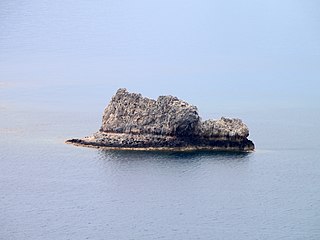
WValenti is a rock close to the northwestern coast of Crete in the Aegean Sea. It is just south of the island of Imeri Gramvousa and the islet of Arnaouti. Administratively, it is located within the municipality of Kissamos, in Chania regional unit.