 W
WAgate Pass or Agate Passage is a high-current tidal strait in Puget Sound connecting Port Madison and mainland Kitsap County. It lies between Bainbridge Island and the mainland of the Kitsap Peninsula near Suquamish. It leads south towards Bremerton, extending about one mile (1.6 km) in a straight, southwesterly direction. The depth is about 20 feet (6.1 m). The shores are wooded and fairly steep. The shoreline is mostly rocky and fringed with kelp to Point Bolin. The tidal currents have velocities up to six knots; the flood tide sets southwesterly, and the ebb tide northeasterly.
 W
WBowman Bay is a bay in the state of Washington, United States. It was formerly called Reservation Bay, having been part of a military reservation. In 1977 it was given its current name in honor of Amos Bowman, a European settler of nearby Fidalgo Island. The name of Anacortes, Washington on Fidalgo Island is derived from the name of Bowman's wife, Anna Curtis.
 W
WThe Colvos Passage is a tidal strait within Puget Sound in the American state of Washington running west of Vashon Island between the island and the Kitsap Peninsula. It lies just north of the Dalco Passage. Colvos Passage has a permanent predominantly northbound current, in contrast to the rest of Puget Sound which varies with the tide. The communities of Fragaria, Olalla, Sunrise Beach, Spring Beach, Maplewood, Lisabeula, Paradise Cove and Sylvan Beach are located on Colvos Passage.
 W
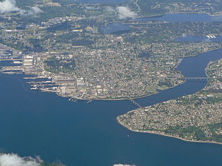
WCommencement Bay is a bay of Puget Sound in the U.S. state of Washington. The city of Tacoma is located on the bay, with the Port of Tacoma occupying the southeastern end. A line drawn from Point Defiance in the southwest to Browns Point in the northeast serves to mark the generally accepted division between the bay and the open sound. Commencement Bay has become home to one of the most active commercial ports in the world. The Port of Tacoma is the main port facility.
 W
WDalco Passage is a tidal strait within Puget Sound in the U.S. state of Washington. Located between the southern end of Vashon Island and the mainland near Tacoma, Dalco Passage connects the northern main Puget Sound basin to the southern basin, via the Tacoma Narrows strait. Colvos Passage, Commencement Bay, and Quartermaster Harbor are also connected to Dalco Passage.
 W
WDeception Pass is a strait separating Whidbey Island from Fidalgo Island, in the northwest part of the U.S. state of Washington. It connects Skagit Bay, part of Puget Sound, with the Strait of Juan de Fuca. A pair of bridges known collectively as Deception Pass Bridge cross Deception Pass. The bridges were added to the National Register of Historic Places in 1982.
 W
WFoulweather Bluff is a privately owned protected area and a cliff that lies on the north end of the Kitsap Peninsula along Puget Sound, on the east side of the entrance to the Hood Canal.
 W
WFragaria is an unincorporated community in Kitsap County, Washington, United States.
 W
WGlen Acres is a community on Vashon Island located about two miles north of the town of Vashon.
 W
WHammersley Inlet, in southwestern Puget Sound in the U.S. state of Washington, is an arm of water leading to Shelton, Washington and Oakland Bay. Hammersley Inlet is also known as Big Skookum.
 W
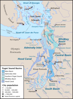
WHood Canal is a fjord forming the western lobe, and one of the four main basins, of Puget Sound in the US state of Washington. It is one of the minor bodies of water that constitute the Salish Sea. Hood Canal is not a canal in the sense of being a man-made waterway—it is a natural waterway.
 W
WThe Key Peninsula is a finger of land in Puget Sound, Washington, United States. It is approximately 16 miles (26 km) long and extends south from the Kitsap Peninsula. It is part of Pierce County, Washington. Some of its towns include: Wauna, Key Center, Vaughn, Home, Lakebay, and Longbranch. Its name is derived from the key-like shape of the peninsula.
 W
WThe Kitsap Peninsula lies west of Seattle across Puget Sound, in Washington state in the Pacific Northwest. Hood Canal separates the peninsula from the Olympic Peninsula on its west side. The peninsula, a.k.a. "the Kitsap", encompasses all of Kitsap County except Bainbridge and Blake Islands, as well as the northeastern part of Mason County and the northwestern part of Pierce County. The highest point on the Kitsap Peninsula is Gold Mountain. The U.S. Navy's Puget Sound Naval Shipyard, and Naval Base Kitsap are on the Peninsula. Its main city is Bremerton.
 W
WOakland Bay is a tidal estuarial body of water near the town of Shelton, Washington. It is connected to the larger Puget Sound via Hammersley Inlet. The community of Bay Shore, Washington was located on Oakland Bay. The major freshwater inlet is Goldsborough Creek, which runs through the town of Shelton.
 W
WPickering Passage is a strait, in the southern end of part of Puget Sound in the U.S. state of Washington. Entirely within Mason County, the Pickering Passage separates Hartstine Island from the mainland, and connects Totten Inlet with the north end of Case Inlet.
 W
WPoint No Point is an outcropping of land on the northeast point of the Kitsap Peninsula in Washington, the United States. It was the location of the signing of the Point No Point Treaty and is the site of the Point No Point Light. It was named by Charles Wilkes during the United States Exploring Expedition of Puget Sound in 1841.
 W
WPoint Wilson is at the end of the Quimper Peninsula, a northeast extension of the Olympic Peninsula and the northeasternmost point of Jefferson County, Washington, United States, approximately two miles north of the Port Townsend business district.
 W
WPort Orchard, part of Washington state's Puget Sound, is the strait that separates Bainbridge Island on the east from the Kitsap Peninsula on the west. It extends from Liberty Bay and Agate Pass in the north to Sinclair Inlet and Rich Passage in the south. It was named in May 1792 by George Vancouver after Harry Masterman Orchard, ship's clerk of Vancouver's ship Discovery.
 W
WThe Port Washington Narrows is a tidal strait located in Bremerton, Washington, United States. The northwest entrance is marked on the west side by Rocky Point, and the southeast entrance is located at Point Turner on the west side and Point Herron on the east side. It is located between downtown Bremerton and the Manette Peninsula.
 W
WQuartermaster Harbor is a small harbor located in southern Puget Sound, in Vashon Island, Washington state.
 W
WRich Passage is a tidal strait in Puget Sound, allowing access to Bremerton, Washington, Sinclair Inlet, and Dyes Inlet. It separates Bainbridge Island from the Manchester area of Kitsap Peninsula. Due to the activities at Puget Sound Naval Shipyard, Rich Passage has a high volume of marine traffic. The Seattle-Bremerton ferry, part of the Washington State Ferries, travels the length of Rich Passage on its route.
 W
WSaratoga Passage lies in Puget Sound between Whidbey Island and Camano Island.
 W
WShilshole Bay is the part of Puget Sound east of a line drawn northeasterly from Seattle's West Point in the southwest to its Golden Gardens Park in the northeast. On its shores lie Discovery Park, the Lawton Wood section of the Magnolia neighborhood, the neighborhood of Ballard, and Golden Gardens Park. It is home to the Shilshole Bay Marina on Ballard's Seaview Avenue N.W. and communicates with the Lake Washington Ship Canal via the Ballard Locks.
 W
WSkagit Bay is a bay and strait located in the U.S. state of Washington. It is part of the Whidbey Island Basin of Puget Sound. The Skagit River empties into Skagit Bay. To the south, Skagit Bay connects with the rest of Puget Sound via Saratoga Passage and Possession Sound. The boundary between Saratoga Passage and Skagit Bay is between Polnell Point on Whidbey Island and Rocky Point on Camano Island. To the northwest, Skagit Bay connects to the Strait of Juan de Fuca via the narrow strait of Deception Pass. A third waterway, the Swinomish Channel, connects Skagit Bay with Padilla Bay to the north.
WSkagit Bay is a bay and strait located in the U.S. state of Washington. It is part of the Whidbey Island Basin of Puget Sound. The Skagit River empties into Skagit Bay. To the south, Skagit Bay connects with the rest of Puget Sound via Saratoga Passage and Possession Sound. The boundary between Saratoga Passage and Skagit Bay is between Polnell Point on Whidbey Island and Rocky Point on Camano Island. To the northwest, Skagit Bay connects to the Strait of Juan de Fuca via the narrow strait of Deception Pass. A third waterway, the Swinomish Channel, connects Skagit Bay with Padilla Bay to the north.
 W
WThe Tacoma Narrows, a strait, is part of Puget Sound in the U.S. state of Washington. A navigable maritime waterway between glacial landforms, the Narrows separates the Kitsap Peninsula from the city of Tacoma.
 W
WThree Tree Point is a low, gravelly, triangle-shaped spit jutting into the east side of Puget Sound. It is about the midpoint between Seattle and Tacoma. It is referred to on some navigation charts as "Point Pully", in recognition of crew member Robert Pulley of the Wilkes Expedition.