 W
WMount Adams, known by some Native American tribes as Pahto or Klickitat, is a potentially active stratovolcano in the Cascade Range. Although Adams has not erupted in more than 1,000 years, it is not considered extinct. It is the second-highest mountain in Washington, after Mount Rainier.
 W
WAdams Glacier is situated on the northwest flank of Mount Adams, a 12,281-foot (3,743 m) stratovolcano in the U.S. state of Washington. Much of it becomes the source of Adams Creek, a tributary of the Cispus River. It is the largest glacier on Mount Adams, and the second largest in the contiguous United States, flowing down from the summit ice cap at over 12,000 feet (3,700 m) for over 2.5 miles (4.0 km) to a terminus near 7,000 feet (2,100 m).
 W
WAvalanche Glacier is located on the west to southwest slopes of Mount Adams a stratovolcano in the Gifford Pinchot National Forest in the U.S. state of Washington. The glacier descends from the White Salmon Glacier at 10,200 ft (3,100 m) to a terminus near 7,600 ft (2,300 m). Avalanche Glacier has been in a general state of retreat for over 100 years and lost 59 percent of its surface area between 1904 and 2006.
 W
WBabyshoe Pass, is a high pass within United States National Forests. Forest Route 23 traverses the pass, northwest of Mount Adams in the State of Washington, between Mount Adams flank to the east and Babyshoe Ridge to the west. The pass separates the Lewis River Watershed and the Cispus River drainage. It was built to connect a Forest Highway together, providing the main north-south access on the east side of the Gifford Pinchot National Forest and the many trails within or near the Mount Adams Wilderness and the Midway High Lakes Area.
 W
WThe Big Tree was a massive Ponderosa pine tree in an old-growth pine and fir forest in southern Washington state, at the southern base of Mount Adams. The area is managed by the Mount Adams Ranger District of the Gifford Pinchot National Forest. The tree was 202 feet (62 m) tall with a diameter of 7 feet (210 cm), and was one of the largest known Ponderosa pines in the world. It had been stressed by attacks from mountain pine beetles and its death in 2015 was confirmed the following year.
 W
WThe Cispus River is about 54 miles (87 km) long and flows into the Cowlitz River at Lake Scanewa in the Cascade Range of Washington. Its tributaries drain most of south-central and southeastern Lewis County, extreme northeast Skamania County, and some of western Yakima County.
 W
WConboy Lake National Wildlife Refuge is located on the east slope of the Cascade Mountains at the base of 12,281-foot (3,743 m) Mount Adams in southern Washington state.
 W
WCrescent Glacier is located on the southeast slopes of Mount Adams in the U.S. state of Washington in Gifford Pinchot National Forest. A small subpeak of Mount Adams, named South Butte, rises nearby. Crescent Glacier is close to the Gotchen Glacier which is located just to the east. Crescent Glacier lies in a small south-facing cirque with a steep headwall. The glacier ranges in elevation from 8,400 ft (2,600 m) at the foot of the steep cliff to 7,900 ft (2,400 m) at the moraine. One arm of the glacier extends south down to 7,600 ft (2,300 m). Between 1904 and 2006, Crescent Glacier lost 6 percent of its surface area.
WGotchen Glacier is located on the south slopes of Mount Adams a stratovolcano in the Gifford Pinchot National Forest in the U.S. state of Washington. The glacier descends from approximately 8,200 ft (2,500 m) to a terminus near 7,400 ft (2,300 m) below which an old terminal moraine and proglacial lake exist. Gotchen Glacier has been in a general state of retreat for over 100 years and lost 78 percent of its surface area between 1904 and 2006.
 W
WHorseshoe Lake is a lake situated in the east side of the Midway High Lakes Area below Mount Adams' northwest flank. The lake is popular for camping, quiet boating, and hiking and biking on a trail halfway around the lake. Other activities include scenic viewing and fishing. The lake offers an eleven-site campground, administered by the Gifford Pinchot National Forest in the State of Washington.
WKlickitat Glacier is located on the east slopes of Mount Adams a stratovolcano in the U.S. state of Washington. Though within the Mount Adams Wilderness, the glacier is situated within the boundaries of the Yakama Indian Reservation. The glacier descends from approximately 12,000 ft (3,700 m) to a terminus near 7,200 ft (2,200 m) below which an old lateral moraine once was the northern margin of the glacier. Klickitat Glacier has been in a general state of retreat for over 100 years and lost 46 percent of its surface area between 1904 and 2006.
 W
WThe Klickitat River is a tributary of the Columbia River, nearly 96 miles (154 km) long, in south-central Washington in the United States. It drains a rugged plateau area on the eastern side of the Cascade Range northeast of Portland, Oregon. In 1986, 10 miles (16 km) of the river were designated Wild and Scenic from the confluence with Wheeler Creek, near the town of Pitt, to the confluence with the Columbia River.
WLava Glacier is located on the north slopes of Mount Adams a stratovolcano in Gifford Pinchot National Forest in the U.S. state of Washington. The glacier descends from approximately 10,000 ft (3,000 m) to a terminus near 7,800 ft (2,400 m). Lava Glacier has been in a general state of retreat for over 100 years and lost 74 percent of its surface area between 1904 and 2006.
 W
WThe Lewis River is a tributary of the Columbia River, about 95 miles (153 km) long, in southwestern Washington in the United States. It drains part of the Cascade Range north of the Columbia River. The drainage basin of the Lewis River covers about 1,046 square miles (2,709 km2). The river's mean annual discharge is about 6,125 cubic feet per second (173.4 m3/s). Unlike nearby Lewis County and Fort Lewis the Lewis River was not named for Meriwether Lewis, but rather for A. Lee Lewis, an early colonizer who homesteaded near the mouth of the river.
 W
WLyman Glacier is located on the north slopes of Mount Adams a stratovolcano in Gifford Pinchot National Forest in the U.S. state of Washington. The glacier is also within the Yakama Indian Reservation and descends from near the summit of Mount Adams at approximately 11,400 ft (3,500 m) to a terminus near 7,800 ft (2,400 m). Below 9,000 ft (2,700 m) the glacier splits into three distinct lobes. Lyman Glacier has been in a general state of retreat for over 100 years and lost 34 percent of its surface area between 1904 and 2006.
 W
WMazama Glacier is located on the southeast slopes of Mount Adams a stratovolcano in the U.S. state of Washington. Mazama Glacier is in the Yakama Indian Reservation. The glacier descends from approximately 10,800 ft (3,300 m) to a terminus near 7,600 ft (2,300 m). Mazama Glacier has been in a general state of retreat for over 100 years and lost 46 percent of its surface area between 1904 and 2006.
 W
WMidway High Lakes Area, also known as High Lakes Area is a United States Forest Service designated area located in Washington’s Cascade Mountains. It lies on a high plateau on Mount Adams' northwestern flank. It is between the Goat Rocks on the north and Mount Hood to the south and contains Takhlakh Lake along with several other lakes. The area offers five scenic high elevation lakes all within a seven mile radius. It is administered by the Gifford Pinchot National Forest. While even the most visited areas at Mount Adams pale in comparison to nearby St. Helens or Rainier, it is by its own standards one of the most popular recreational areas around Mount Adams. Some of the lakes offers photogenic views of Mount Adams from across the lake.
 W
WThe Mount Adams Recreation Area is a 21,000-acre (8,500 ha) recreation area in the U.S. state of Washington managed by the Yakama Nation Tribal Forestry Program. The area encompasses an ecologically complex and geologically active landscape. The region features the most rugged side of Mount Adams, including canyons and the Great Gap section of the Mount Adams circumnavigation route, a three-mile trail-less section over two great canyons and many difficult glacial creeks. At 12,276 feet (3,742 m), Mount Adams is one of the major Cascade mountains. The recreation area is on the east side of the mountain and is part of the Yakama Indian Reservation and includes the popular Bird Creek Meadows area.
 W
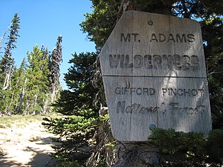
WThe Mount Adams Wilderness is a 47,708-acre (19,307 ha) wilderness area in the U.S. state of Washington managed by the U.S. Forest Service. The wilderness encompasses an ecologically complex and geologically active landscape. Weather differs between the dry eastside and moist westside of the mountain. At 12,276 feet (3,742 m), Mount Adams is one of the major Cascade mountains. The wilderness area is on the west side of the mountain and is part of the Gifford Pinchot National Forest. The east side of the mountain is part of the Yakama Nation, with the southeast side part of the Mount Adams Recreation Area, and includes Bird Creek Meadows.
 W
WOlallie Lake is an alpine lake and one of several in the area fed by streams coming off the glaciers from nearby Mount Adams. A small, but popular Olallie Lake Campground offers scenic camping as well as non-motorized boating and fishing experiences. It is located at 4,200 feet elevation in the Gifford Pinchot National Forest, in Washington state.
WPinnacle Glacier is located on the west slopes of Mount Adams a stratovolcano in Gifford Pinchot National Forest in the U.S. state of Washington. The glacier descends from approximately 10,000 ft (3,000 m) to a terminus near 7,200 ft (2,200 m). Pinnacle Glacier lost 7 percent of its surface area between 1904 and 2006.
WRusk Glacier is located on the eastern face of Mount Adams in the U.S. state of Washington. Starting at an elevation of over 10,200 ft (3,100 m) at just below The Castle, the glacier flows eastward down slope. A significant portion of the glacier is covered by rock debris and in the middle of the glacier, at about 9,200 ft (2,800 m), there is a small ice-free island of rock. The glacier terminates at about 7,500 ft (2,300 m) at its rock-covered moraine. The glacier has decreased in surface area by 23 percent between 1904 and 2006.
 W
WTakhlakh Lake is a lake situated 7.3 miles (11.7 km) northwest of Mount Adams in the U.S. state of Washington. It is fed by a few small unnamed inflow creeks originating near Takh Takh Meadows, tributary to the Cispus River. A popular 53-site campground on the west side of the lake brings summer and early fall campers as well as hikers hiking the Takhlakh Loop Trail and the Takh Takh Meadows Trail, and nearby trails in the Mount Adams Wilderness. A day use area offers a picnic area and provides a boat ramp as well. The lake is one of the five lakes, all within a seven-mile radius, in the Midway High Lakes Area. It is managed by the Gifford Pinchot National Forest.
 W
WTrout Lake is an unincorporated community and census-designated place (CDP) in Klickitat County, Washington, United States. The population was 557 at the 2010 census. The town is notable for its organic dairy and herb farms, and as an access point to Mount Adams and the Gifford Pinchot National Forest.
WWhite Salmon Glacier is located on Mount Adams in the U.S. state of Washington. The glacier starts southwest of the summit crater at an elevation of 11,600 ft (3,500 m). Ice flows southwest downhill until the glacier's terminus at about 9,600 ft (2,900 m) elevation. The glacier also contributes ice to the much larger Avalanche Glacier at an elevation of 10,200 ft (3,100 m). White Salmon Glacier has decreased in surface area by 86 percent between 1904 and 2006.
 W
WThe White Salmon River is a 44-mile (71 km) tributary of the Columbia River in the U.S. state of Washington. Originating on the slopes of Mount Adams, it flows into the Columbia Gorge near the community of Underwood. Parts of the river have been designated Wild and Scenic. The principal tributaries of the White Salmon River include Trout Lake and Buck, Mill, Dry, Gilmer, and Rattlesnake Creeks.
WWilson Glacier is located on the east slopes of Mount Adams a stratovolcano in the U.S. state of Washington. The glacier is within the Yakama Indian Reservation. The glacier descends from approximately 10,600 ft (3,200 m) to a terminus near 7,400 ft (2,300 m). Wilson Glacier has been in a general state of retreat for over 100 years and lost 14 percent of its surface area between 1904 and 2006.