 W
WThis list of highest mountains of New Guinea shows all mountains on the island of New Guinea that are at least 3750 m high and have a topographic prominence of 500 m or more. These c. 50 peaks are also the highest mountains of Australasia and the continent of Australia, where, outside New Guinea, the highest mountain is Aoraki / Mount Cook in New Zealand with a height of 3724 m. A list of highest mountains of Oceania with the same limitations is almost identical, with the addition of the Hawaiian volcanoes of Mauna Kea and Mauna Loa in 18th and 20th positions. The list also shows the 36 highest thus defined mountains of Indonesia, except for the 3805 m high Gunung Kerinci on Sumatra, and the 16 highest mountains of Papua New Guinea.
 W
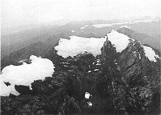
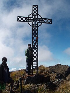
WMount Albert Edward is a 3,990-metre-high (13,091 ft) mountain in the Wharton Range in Central Province, Papua New Guinea. The mountain consists of two peaks about 400 metres apart, a cross marks the top of the slightly higher western peak and a trig station marks the eastern peak. The mountain lies approximately 120 km north of Port Moresby.
 W
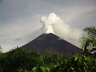
WBagana is an active volcano located in the centre of the island of Bougainville, Papua New Guinea, the largest island of the Solomon group. It is the most active volcano in the country, occupying a remote portion of central Bougainville Island. It is one of Melanesia's youngest and most active volcanoes.
WMount Balbi is a Holocene stratovolcano located in the northern portion of the island of Bougainville, Papua New Guinea. A gentle prominence at 05°54′09″S 154°59′28″E is the highest point of the island. There are five volcanic craters east of the summit, one of which contains a crater lake. There are numerous fumaroles near the craters, though Balbi has not erupted in historic time.
 W
WMount Bangeta, also known as Mount Sarawaget, is the highest mountain in Morobe Province, Papua New Guinea. It lies in the Saruwaged Range and at 4,121 m (13,520 ft) it is one of the highest mountains in the country.
 W
WMount Bellamy is a mountain in the Owen Stanley Range in south-eastern Papua New Guinea. The mountain rises to 2,250 metres (7,400 ft).
WBilly Mitchell is a volcano in the central part of the island of Bougainville, just north-east of the Bagana Volcano in Papua New Guinea. It is a small pyroclastic shield truncated by a 2 km wide caldera filled by a crater lake. It is named after Billy Mitchell, a 20th-century United States Army general who is regarded as the father of the United States Air Force.
 W
WThe Bola volcano, also known as Wangore, is an andesitic stratovolcano, located south-west of the Dakataua caldera. It is 1,155 metres (3,789 ft) tall and has a 400 m (1,310 ft) wide summit crater.
WMount Bosavi is a mountain in the Southern Highlands province, Papua New Guinea. It is the collapsed cone of an extinct volcano on the Great Papuan Plateau, part of the Kikori River basin. The crater is approximately 4 km wide and 1 km deep; it is home to a number of endemic species.
 W
WMount Giluwe is the second highest mountain in Papua New Guinea at 4,367 metres (14,327 ft), and the fifth highest peak on the island of New Guinea. It is located in the Southern Highlands province and is an old shield volcano with vast alpine grasslands. Ancient volcanic plugs form its two summits, with the central peak the highest and an east peak about 2 kilometres (1.2 mi) away at 4,300 m (14,108 ft). Giluwe has the distinction of being the highest volcano on the Australian continent and Oceania, and is thus one of the Volcanic Seven Summits.
WMount Hagen, named after the German colonial officer Curt von Hagen (1859–1897), is the second highest volcano in Papua New Guinea and on the Australian continent, ranking behind only its neighbour Mount Giluwe which is roughly 35 kilometres (22 mi) to the south-west. It is located on the border between the Western Highlands and Enga Provinces, about 24 kilometres (15 mi) north-west of the city of Mount Hagen which is named after it.
WMount Kubor is a peak in the Kubor Range in the New Guinea Highlands, in the Simbu Province of Papua New Guinea.
 W
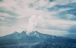
WMount Lamington is an andesitic stratovolcano in the Oro Province of Papua New Guinea. The forested peak of the volcano had not been recognised as such until its devastating eruption in 1951 that caused about 3,000 deaths.
 W
WLangila is one of the most active volcanoes of New Britain, Papua New Guinea. It consists of four overlapping volcanic cones on the eastern flank of an older extinct volcano, Talawe. Talawe is the largest volcano in Cape Gloucester. There have been dozens of recorded eruptions since the 19th century from three separate volcanic craters at the summit of Langila. The most recent eruptive cycle of Langila began in August 2006 and continued into early 2007. Volcanic activity at Langila consists of Strombo-Vulcanian and Vulcanian eruptions and lava flows. Langila is one of the most active volcanoes in the Bismark archipelago. The smallest crater is crater number 3.
 W
WLikuruanga is a stratovolcano in easternmost West New Britain Province on the island of New Britain, Papua New Guinea. Its low, dissected edifice contains a large volcanic crater that is breached to the north. The last known eruption from Likuruanga is prehistoric in age, having taken place during the Pleistocene epoch.
WLoloru is a pyroclastic shield volcano located in the southern region of Bougainville Island, within the Autonomous Region of Bougainville of northeastern Papua New Guinea.
WMount Shungol is an ultra-prominent summit to the west of Lae, in Morobe Province, Papua New Guinea. It is in the Herzog Mountain Range and has an elevation of 2,752 metres (9,029 ft). The Buang people claim ownership to the top of Mount Shungol.
WMount Suckling or Goropi, is the highest peak of the Goropu Mountains, part of the Owen Stanley Range in south-eastern Papua New Guinea. It lies about 250 kilometres (160 mi) east of Port Moresby. Situated on a relatively narrow peninsula, it lies only about 60 km (40 mi) from the sea to both the north-east and the south. While not the highest peak in the Owen Stanley Range, it is the most topographically prominent peak in the range, and it is in fact the third most prominent peak on the island of New Guinea. The peak rises above the timberline, while its lower slopes are well-forested.
 W
WSulen is an isolated mountain peak in Sandaun Province, Papua New Guinea. It is the highest peak in Torricelli Mountains.
WMount Taron or Mount Agil is the highest point in the Hans Meyer Range on New Ireland in Papua New Guinea. It is the highest point of New Ireland and the entire Bismarck Archipelago.
WTore is a volcano located in the northern part of the island of Bougainville, Papua New Guinea. Violent Pleistocene eruptions produced two ignimbrite fans stretching west to the coast, and a 6 km by 9 km caldera. A post-caldera lava cone on the caldera's southern rim is the source of lava flows. Well-preserved features suggests a recent date for this cone and a nearby ash cone.
WMount Trafalgar is an extinct volcano on the north east coast of Oro Province, Papua New Guinea. The mountain is a major andesite volcano, with the magma known for its high levels of Nickel and Chromium. Captain John Moresby named the mountain after the naval battle of Trafalgar.
 W
WUlawun is a basaltic and andesitic stratovolcano in West New Britain Province, on the island of New Britain in Papua New Guinea.
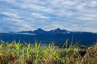
WMount Victoria is the highest point in the Owen Stanley Ranges in Central Province, Papua New Guinea at 4,038 metres (13,248 ft). It lies approximately 75 km north-north-east of Port Moresby and can be seen on a clear day from the city.
WMount Victory is an active volcano on the north east coast of Oro Province, Papua New Guinea with a height of 1,884 metres (6,181 ft). It is bounded by the Ajova River.
WMount Vineuo, also known as Mount Oiautukekea, is a mountain on Goodenough Island, Papua New Guinea. The mountain is 2,536 metres (8,320 ft) above sea level. The mountain is the highest peak in the D'Entrecasteaux Islands.
 W
WMount Wilhelm is the highest mountain in Papua New Guinea at 4,509 metres (14,793 ft). It is part of the Bismarck Range and the peak is the point where three provinces, Simbu, Jiwaka and Madang, meet. The peak is also known as Enduwa Kombuglu, or Kombugl'o Dimbin, in the local Kuman.