 W
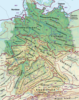
WThis division of Germany into major natural regions takes account primarily of geomorphological, geological, hydrological, and pedological criteria in order to divide the country into large, physical units with a common geographical basis. Political boundaries play no part in this, apart from defining the national border.
 W
WThe Alpine Foreland, less commonly called the Bavarian Foreland, Bavarian Plateau or Bavarian Alpine Foreland, refers to a triangular region of plateau and rolling foothills in Southern Germany, stretching from Lake Constance in the west to beyond Linz on the Danube in the east, with the Bavarian Alps forming its south boundary and the Danube its northern extent.
 W
WThe Aper Tief is a stream in Lower Saxony, Germany.
 W
WThe Central Saxon Hills, is a region of Hügelland with indistinct boundaries in the centre of the German state of Saxony.
 W
WThe Central Uplands is one of the three major natural regions of Germany. It stretches east to west across the country. To the north lies the North German Plain or Northern Lowland; to the south, the Alps and the Alpine Foreland.
 W
W W
WThe Eider-Treene Depression is a landscape in west Schleswig-Holstein in North Germany. It covers 500 square kilometres (190 sq mi) around the rivers Eider, Treene and Sorge. The Eider-Treene Depression is the largest wetland in the German state of Schleswig-Holstein. It includes one third of the moorland (bog) in the state and is a habitat to the largest inland group of meadow birds. To the north, its border runs between Hollingstedt and Treia, to the east near Rendsburg, to the south the boggy depression reaches to the Hanerau and Haalerau beyond the Kiel Canal. Its western boundary with the Eiderstedt Marsh is unclear as marsh, bog and geest are interspersed. The region comprises the river valleys and their interfluvial geest ridges (Geestkernen). The landscape was formed during the ice ages, and altered by man as a result of dams and weirs built across the Eider, which was still a tidal river as far as Rendsburg until the 1920s. The region recently is encouraging "nature tourism" with walking, riding, cycling and canoe trips.
 W
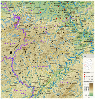
WThe Eifel is a low mountain range in western Germany and eastern Belgium. It occupies parts of southwestern North Rhine-Westphalia, northwestern Rhineland-Palatinate and the southern area of the German-speaking Community of Belgium.
 W
WThe Elbe marshes are an extensive region of marsh or polderland along the lower and middle reaches of the River Elbe in northern Germany. It is also referred to as the Lower Elbe Marsch by Dickinson and is region D24 in the BfN's list of the natural regions of Germany. The Germans refer to these polders as Marschen.
 W
WThe Haller Ebene is a plain in the German state of Baden-Württemberg which forms part of the Hohenlohe Plain and stretches from Bad Mergentheim via Rothenburg, Uffenheim, Crailsheim, Öhringen as far as Schwäbisch Hall. The Haller Ebene specifically refers to that region of the Hohenloher Ebene around the town of Schwäbisch Hall.
 W
WThe Harz is a highland area in northern Germany. It has the highest elevations for that region, and its rugged terrain extends across parts of Lower Saxony, Saxony-Anhalt, and Thuringia. The name Harz derives from the Middle High German word Hardt or Hart, Latinized as Hercynia. The Brocken is the highest summit in the Harz with an elevation of 1,141.1 metres (3,744 ft) above sea level. The Wurmberg is the highest peak located entirely within the state of Lower Saxony.
 W
WThe Heide-Itzehoe Geest is a division of a larger natural region in the west of the German state of Schleswig-Holstein. It belongs to the Hohe Geest and thus to the Schleswig-Holstein Geest natural region.
 W
WThe High Fichtel Mountains, or High Fichtel, form a mountainous and heavily forested range consisting of several mountain chains in the shape of a horseshoe, the Fichtel Mountain Horseshoe (Fichtelgebirgs-Hufeisen), that rings the Selb-Wunsiedel Plateau.
 W
WHolstein Switzerland is a hilly area with a patchwork of lakes and forest in Schleswig Holstein, Germany, reminiscent of Swiss landscape. Its highest point is the Bungsberg. It is a designated nature park as well as an important tourist destination in Northern Germany situated between the cities of Kiel and Lübeck.
 W
WThe Iller-Lech Plateau, also known as the Upper Swabian Plateau, is one of the natural regions of Germany.
 W
WThe Klues Forest is a forest which lies in Schleswig-Holstein/North-Germany, between Flensburg and Harrislee.
WThe Krempe Marsh is one of the Holstein Elbe marshes and lies northeast of the River Elbe between its tributaries of the Krückau and Stör and the edge of the geest. The main settlement in the Krempe Marsh is the town of Krempe; it is bisected by the Krempau river.
 W
WThe Lange Berge are a small range of the German Central Uplands, up to 527.2 m above sea level (NN), which lie mainly in the Bavarian provinces of Upper Franconia with northwestern foothills in Thuringia.
 W
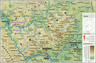
WThe Limburg Basin is one of the two large intramontane lowland areas within the Rhenish Massif in Germany, the other being the Middle Rhine Basin. It forms the central part of the natural region of the Gießen-Koblenz Lahn Valley between the Weilburg Lahn Valley Region and the Lower Lahn Valley on both sides of the Lahn around the town of Limburg.
 W
WThe Lower Bavarian Upland, Lower Bavarian Hill Country or Lower Bavarian Hills, are part of the tertiary Hügelland or hill country south of the River Danube and cover much of the land within the Bavarian province of Lower Bavaria in southern Germany. To the north it is bordered by the Gäuboden region and the Bavarian Forest; to the south by Upper Bavaria, to the east by the Lower Inn Valley and to the west by the Franconian Jura. In the western part of the Lower Bavarian Hills lies the Hallertau, the world's largest hop-growing region. It belongs to two of officially defined natural regions in Germany: the eponymous Lower Bavarian hills and the Isar-Inn Gravel Beds (Isar-Inn-Schotterplatten) and is sub-divided into the Danube-Isar Hills (Donau-Isar-Hügelland) and the Isar-Inn Upland (Isar-Inn-Hügelland) with the River Isar as the boundary. The hills continue over the border into Austria as the Upper Austrian Hills.
 W
WLüneburg Heath is a large area of heath, geest, and woodland in the northeastern part of the state of Lower Saxony in northern Germany. It forms part of the hinterland for the cities of Hamburg, Hanover and Bremen and is named after the town of Lüneburg. Most of the area is a nature reserve. Northern Low Saxon is still widely spoken in the region.
 W
WThe Magdeburg Börde is the central landscape unit of the state of Saxony-Anhalt and lies to the west and south of the eponymous state capital Magdeburg. Part of a loess belt stretching along the southeastern rim of the North German Plain, it is noted for its very fertile Chernozem soils.
WThe Schleswig Geest lies between the North Frisian Marsh and Schleswig-Holstein Uplands in the north of Schleswig-Holstein in Germany. To the south, it transitions into the Eider-Treene Depression. Geest is one of the three landscape forms in Schleswig-Holstein. Its sandy soils contrast with the fertile soils of the marshes and hill country. The Schleswig Geest was settled in the 6th century by the Danes and Jutes. The Ochsenweg, one of the most important communication arteries in the North European region, runs through the Schleswig Geest. The so-called Geest Ridge (Geestrücken) was the best strip of land for a north-south route. Whilst the marsh was too soft and wet for long-distance roads on which to move cattle and armies, the Angeln was just too hilly.
 W
WThe Senne is a natural region of moorland and sand dunes in the Regierungsbezirk of Detmold, in the state of Nordrhein-Westfalen in west-central Germany. It lies to the west of the Teutoburger Forest, and has an area of approximately 210 km2. It lies between the cities of Bielefeld to the north-west, Detmold to the north-east, and Paderborn to the south.
 W
WOn 8 March 1988 the Bavarian State Ministry for State Development and the Environment designated an area of 1,280 square kilometres (490 sq mi) in the Steigerwald in North Bavaria, Germany, as the Steigerwald Nature Park. About half the area consists of protected landscapes. The nature park is run by the Steigerwald Tourist Association and Steigerwald Nature Park.
 W
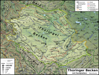
WThe Thuringian Basin is a depression in the central and northwest part of Thuringia in Germany which is crossed by several rivers, the longest of which is the Unstrut. It stretches about 60 kilometres (37 mi) from north to south and around 120 kilometres (75 mi) from east to west. Its height varies from about 150 to 250 m above sea level (NN).
 W
WThe Upland is a low mountain region forming the northeastern part of the High Sauerland and belongs the German state of Hesse, unlike the remainder of the High Sauerland which lies in Westphalia. The Upland falls within the district of Waldeck-Frankenberg, in North Hesse and corresponds to the territory of the municipality of Willingen.