 W
WThe Allegheny Plateau, in the United States, is a large dissected plateau area in western and central New York, northern and western Pennsylvania, northern and western West Virginia, and eastern Ohio. It is divided into the unglaciated Allegheny Plateau and the glaciated Allegheny Plateau.
WThe Glaciated Allegheny Plateau is that portion of the Allegheny Plateau that lies within the area covered by the last glaciation. As a result, this area of the Allegheny Plateau has lower relief and gentler slopes than the relatively rugged Unglaciated Allegheny Plateau. In general, the glaciated lies to the north and west of the unglaciated, and forms an arc in northeastern to southeastern Ohio lying between the glacial till plains and the Unglaciated Allegheny Plateau. The Glaciated Allegheny Plateau extends into a belt of southern New York State and the central Susquehanna River basin.
WThe Unglaciated Allegheny Plateau is located in an arc around southeastern Ohio into western Pennsylvania and West Virginia.
 W
WThe Appalachian Plateau is a series of rugged dissected plateaus located on the western side of the Appalachian Mountains. The Appalachian Mountains are a mountain range that run down the East Coast of the United States. The Appalachian Plateau is the northwestern part of the Appalachian Mountains, stretching from New York to Alabama. The plateau is a second level United States physiographic region, covering parts of the states of New York, Pennsylvania, Ohio, Maryland, West Virginia, Virginia, Kentucky, Tennessee, Alabama, and Georgia.
 W
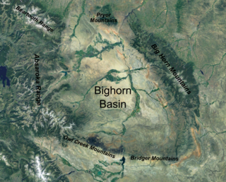
WThe Bighorn Basin is a plateau region and intermontane basin, approximately 100 miles (160 km) wide, in north-central Wyoming in the United States. It is bounded by the Absaroka Range on the west, the Pryor Mountains on the north, the Bighorn Mountains on the east, and the Owl Creek Mountains and Bridger Mountains on the south. It is drained to the north by tributaries of the Bighorn River, which enters the basin from the south, through a gap between the Owl Creek and Bridger Mountains, as the Wind River, and becomes the Bighorn as it enters the basin. The region is semi-arid, receiving only 6–10 in (15–25 cm) of rain annually.
 W
WThe Boston Mountains is a Level III ecoregion designated by the Environmental Protection Agency (EPA) in the U.S. states of Arkansas and Oklahoma. Part of the Ozark Mountains, the Boston Mountains are a deeply dissected plateau. The ecoregion is steeper than the adjacent Springfield Plateau to the north, and bordered on the south by the Arkansas Valley. The Oklahoma portion of the range is locally referred to as the Cookson Hills.
 W
WBroad Top is a plateau located in south-central Pennsylvania. It extends into Huntingdon County to the north, Fulton County to the southeast, and Bedford County to the southwest. It is bounded to the west by Saxton Mountain and Terrace Mountain, and to the east by Sideling Hill. In Bedford County, Harbor Mountain forms the southern boundary. Trough Creek Valley lies between the mountains.
 W
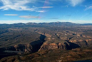
WCaja del Rio is a dissected plateau, of volcanic origin, which covers approximately 84,000 acres of land in northern Santa Fe County, New Mexico, United States. The region is also known as the Caja, Caja del Rio Plateau, and Cerros del Rio. The center of the area is approximately 15 miles (23 km) west of Santa Fe, New Mexico. Most of the Caja is owned by the United States Forest Service and managed by the Santa Fe National Forest. Access is through New Mexico Highway 599, Santa Fe County Road 62, and Forest Service Road 24.
 W
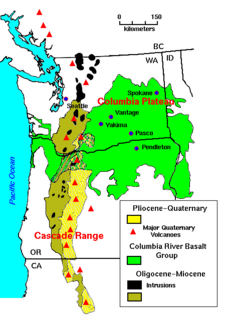
WThe Columbia Plateau is a geologic and geographic region that lies across parts of the U.S. states of Washington, Oregon, and Idaho. It is a wide flood basalt plateau between the Cascade Range and the Rocky Mountains, cut through by the Columbia River.
 W
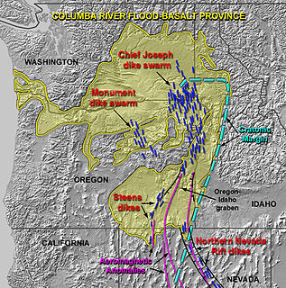
WThe Columbia River Basalt Group is the youngest, smallest and one of the best-preserved continental flood basalt province on Earth, covering over 210,000 km2 (81,000 sq mi) mainly eastern Oregon and Washington, western Idaho, and part of northern Nevada. The basalt group includes the Steen and Picture Gorge basalt formations.
 W
WThe Coteau des Prairies is a plateau approximately 200 miles in length and 100 miles in width, rising from the prairie flatlands in eastern South Dakota, southwestern Minnesota, and northwestern Iowa in the United States. The southeast portion of the Coteau comprises one of the distinct regions of Minnesota, known as Buffalo Ridge.
 W
WThe Coteau du Missouri, or Missouri Plateau, is a large plateau that stretches along the eastern side of the valley of the Missouri River in central North Dakota and north-central South Dakota in the United States. In the Canadian provinces of Saskatchewan and Alberta this physiographic region is classified as the uplands Missouri Coteau, which is a part of the Great Plains Province or Alberta Plateau Region, which extends across the southwest corner of the province of Saskatchewan as well as the southeast corner of the province of Alberta. Historically, in Canada the area was known as the Palliser's Triangle regarded as an extension of the Great American Desert and unsuitable for agriculture and thus designated by Canadian geographer and explorer John Palliser. The terrain of the Missouri Coteau features low hummocky, undulating, rolling hills, potholes, and grasslands. Apart from being a geographical area, the Coteau du Missouri also has a cultural connection to the people of the area, the Metis people of South Dakota along with other Indigenous groups. The history of this plateau is large, and the Coteau du Missouri has a significance to these people.
WThe Cumberland Plateau is the southern part of the Appalachian Plateau in the Appalachian Mountains of the United States. It includes much of eastern Kentucky and Tennessee, and portions of northern Alabama and northwest Georgia. The terms "Allegheny Plateau" and the "Cumberland Plateau" both refer to the dissected plateau lands lying west of the main Appalachian Mountains. The terms stem from historical usage rather than geological difference, so there is no strict dividing line between the two. Two major rivers share the names of the plateaus, with the Allegheny River rising in the Allegheny Plateau and the Cumberland River rising in the Cumberland Plateau in Harlan County, Kentucky.
 W
WThe Edwards Plateau is a geographic region at the crossroads of Central, South, and West Texas. It is bounded by the Balcones Fault to the south and east, the Llano Uplift and the Llano Estacado to the north, and the Pecos River and Chihuahuan Desert to the west. San Angelo, Austin, San Antonio and Del Rio roughly outline the area. The southeast portion of the plateau is known as the Texas Hill Country.
 W
WHunterdon Plateau is a plateau in western Hunterdon County, New Jersey. It borders the higher Musconetcong Mountain to the northwest, the Delaware River to the west, Amwell Valley to the south and the lower lying areas of the Newark Basin to the east.
 W
WThe Intermontane Plateaus of the Western United States is one of eight U.S. Physiographic regions (divisions) of the physical geography of the contiguous United States. The region is composed of intermontane plateaus and mountain ranges. It is subdivided into physiographic provinces, which are each subdivided into physiographic sections.
 W
WThe Llano Estacado, commonly known as the Staked Plains, is a region in the Southwestern United States that encompasses parts of eastern New Mexico and northwestern Texas. One of the largest mesas or tablelands on the North American continent, the elevation rises from 3,000 feet (900 m) in the southeast to over 5,000 feet (1,500 m) in the northwest, sloping almost uniformly at about 10 feet per mile (1.9 m/km).
 W
WThe Modoc Plateau lies in the northeast corner of California as well as parts of Oregon and Nevada. Nearly 1,000,000 acres (400,000 ha) of the Modoc National Forest are on the plateau between the Medicine Lake Highlands in the west and the Warner Mountains in the east.
 W
WThe Ozarks, also known as the Ozark Mountains or Ozark Plateau, is a physiographic region in the U.S. states of Missouri, Arkansas, Oklahoma and the extreme southeastern corner of Kansas. The Ozarks cover a significant portion of northern Arkansas and most of the southern half of Missouri, extending from Interstate 40 in central Arkansas to Interstate 70 in central Missouri.
 W
WThe Pajarito Plateau is a volcanic plateau in north central New Mexico, United States. The plateau, part of the Jemez Mountains, is bounded on the west by the Valles Caldera and on the east by the White Rock Canyon of the Rio Grande. The plateau is occupied by several notable entities, including Bandelier National Monument, the town of Los Alamos and its remote suburb White Rock, and Los Alamos National Laboratory. Elevations range from about 5600 feet at the river to about 7800 feet where the plateau merges into the mountain range.
 W
WThe Pennyroyal Plateau is a large area of Kentucky that features rolling hills, caves, and karst topography in general. It is named for a wild mint that grows in the area. It is also called the "Mississippian Plateau," for the Mississippian geologic age in which it was formed.
 W
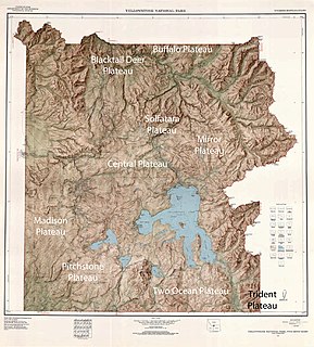
WThere are nine named plateaus in Yellowstone National Park. These plateaus are part of the much larger Yellowstone Plateau and dominate areas in the park south and west of the Gallatin and Absaroka mountain ranges. Four of the plateaus are from rhyolite lava flows that occurred between 110,000 and 70,000 years ago.
 W
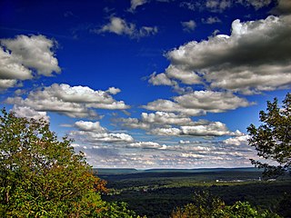
WThe Pocono Mountains, commonly referred to as the Poconos, are a geographical, geological, and cultural region in Northeastern Pennsylvania, United States. The Poconos are an upland of the larger Allegheny Plateau. Forming a 2,400-square-mile (6,200 km2) escarpment overlooking the Delaware River and Delaware Water Gap to the east, the mountains are bordered on the north by Lake Wallenpaupack, on the west by the Wyoming Valley and the Coal Region, and to the south by the Lehigh Valley. The name comes from the Munsee word Pokawachne, which means "Creek Between Two Hills." Much of the Poconos region lies within the Greater New York-Newark, NY-NJ-CT-PA Combined Statistical Area. The wooded hills and valleys have long been a popular recreation area, accessible within a two-hour drive to millions of metropolitan area residents, with many communities having resort hotels with fishing, hunting, skiing, and other sports facilities.
 W
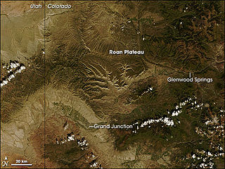
WThe Roan Plateau is a plateau in western Colorado, USA, in Garfield County. It contains a variety of natural resources and scenic terrain: high ridges, deep valleys, desert lands, waterfalls, cutthroat trout, mountain lions, bears, rare plants, and oil and natural gas.
 W
WSand Mountain is a sandstone plateau in northeastern Alabama and northwestern Georgia and southeastern Tennessee where the plateau is known as Raccoon Mountain and Elder Mountain. It is part of the southern tip of the Appalachian mountain chain and it is the largest plateau in the chain. Geologically a continuation of Walden Ridge, Sand Mountain is part of the Cumberland Plateau, separated from the main portion of the plateau by the Tennessee River and Sequatchie Valley. The average elevation on Sand Mountain is around 1,500 feet (460 m) above sea level, compared to about 650 feet (200 m) in the surrounding area. This elevation leads to its having the coolest climate in the state of Alabama. The largest city on Sand Mountain is Albertville, in Marshall County. As of the 2010 census, the population of the city was 21,160.
 W
WThe Santa Rosa Plateau is an upland plateau and southeastern extension of the Santa Ana Mountains in Riverside County, southern California. It is bounded by the rapidly urbanizing Inland Empire cities of Murrieta and Temecula to the northeast and southeast, respectively.
 W
WThe Uncompahgre Plateau in western Colorado is a distinctive large uplift part of the Colorado Plateau. Uncompahgre is a Ute word that describes the water: "Dirty Water" or "Rocks that make Water Red".