 W
WThe Philippines is an archipelago of 7,107 islands with a land area of 300,000 sq. kilometers. Owing to its numerous islands, the country has an irregular coastline that stretches 334,539 kilometers. It is surrounded by the Pacific Ocean on the east, the South China Sea on the north and the west and the Celebes Sea on the south.
 W
WBacoor Bay is a large inlet of southeastern Manila Bay, situated within Cavite province of Luzon Island in the Philippines.
WBalayan Bay is a large bay of Luzon Island in the Philippines. It is part of the Verde Island Passage and its entire shore is in the province of Batangas. The bay is between 23 to 28 kilometres wide. It is separated from the South China Sea to the west by the Calatagan Peninsula, which has Cape Santiago as its southern point. The Calumpan Peninsula forms the bay's eastern side, that separates it from Batangas Bay.
 W
WBaler Bay is a bay in the northeastern portion of Luzon island in the Philippines. It is an extension of the Philippine Sea and bordered by four municipalities of Aurora province.
 W
WBatangas Bay is a semi-enclosed body of water situated in the province of Batangas in Luzon island in the Philippines. The bay is an extension of the Verde Island Passage and is separated from the Balayan Bay to the west by the Calumpan Peninsula, which just out to Maricaban Island across the Maricaban Strait.
 W
WButuan Bay is a bay and extension of the Bohol Sea a.k.a. the Mindanao Sea, in the northeast section of Mindanao in the Philippines. Its main river source is the Agusan River, which empties into the bay at the coastal city of Butuan. Butuan Bay is completely contained with the Agusan del Norte province.
 W
WCañacao Bay is a small bay located within the larger Manila Bay in Luzon island in the Philippines.
 W
WDumanquilas Bay is an arm of the Moro Gulf on the southern side of the Zamboanga Peninsula in western Mindanao island in the Philippines. It is shared between the provinces of Zamboanga del Sur on the eastern and northern shore, and Zamboanga Sibugay on the western shore. An irregularly shaped peninsula extending to Flecha Point separates it from Pagadian Bay to the east, while to the west, the bay connects with Sibuguey Bay through Canalizo Strait which separates Olutanga island from the mainland of Zamboanga. Politically, it is divided between the Zamboanga del Sur municipalities of Margosatubig, Vincenzo Sagun, Lapuyan and Kumalarang, and the Zamboangay Sibugay municipalities of Buug, Malangas and Alicia.
 W
WHonda Bay is a bay on the eastern shore of the island of Palawan near Puerto Princesa City in the southwestern Philippines. Numerous small islands are scattered in the bay, including Arrecife Island which is home to an upscale resort.
 W
WIligan Bay is a bay in Mindanao Island in the Philippines. The bay is part of the Bohol Sea, and curves into the northern coast of Mindanao Island.
 W
WIllana Bay, also known as the Iranun Bay, is a large bay of the Moro Gulf, off the southwestern coast of Mindanao island in the Philippines.
 W
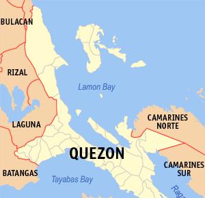
WLamon Bay is a large bay in the southern part of Luzon island in the Philippines. It is a body of water connecting the southern part of Quezon province to the Philippine Sea, a marginal sea of the Pacific Ocean. It borders on the coastal towns of Atimonan, Gumaca, Plaridel, Lopez, Calauag, and the islands of Alabat.
 W
WMacajalar Bay is a deep water bay of the Bohol Sea, located north of the province of Misamis Oriental on Mindanao Island, in the southern part of the Philippines. Cagayan de Oro City, being the regional center of Northern Mindanao, is located in one of its deep-water harbors. Twelve of the municipalities of Misamis Oriental share a coastline with the bay.
 W
WMagellan Bay is a body of water on the northeastern side of Mactan Island near Lapu-Lapu City.
WMangarin Bay is a bay of the South China Sea, on the west coast of Mindoro island, in Occidental Mindoro Province of the Philippines.
 W
WManila Bay is a natural harbor which serves the Port of Manila, in the Philippines. Strategically located around the capital city of the Philippines, Manila Bay facilitated commerce and trade between the Philippines and its neighboring countries, becoming the gateway for socio-economic development even prior to Spanish occupation. With an area of 1,994 km2 (769.9 sq mi), and a coastline of 190 km (118.1 mi), Manila Bay is situated in the western part of Luzon and is bounded by Cavite and Metro Manila on the east, Bulacan and Pampanga on the north, and Bataan on the west and northwest. Manila Bay drains approximately 17,000 km2 (6,563.7 sq mi) of watershed area, with the Pampanga River contributing about 49% of the freshwater influx. With an average depth of 17 m (55.8 ft), it is estimated to have a total volume of 28.9 billion cubic meters. Entrance to the bay is 19 km (11.8 mi) wide and expands to a width of 48 km (29.8 mi). However, width of the bay varies from 22 km (13.7 mi) at its mouth and expanding to 60 km (37.3 mi) at its widest point.
 W
WOrmoc Bay is a large bay in the island of Leyte in the Philippines. The bay is an extension of the Camotes Sea. The city of Ormoc lies at the head of the bay and exports rice, copra and sugar.
 W
WPanguil Bay is an arm of Iligan Bay in Mindanao, Philippines. The bay forms the natural boundary separating the Zamboanga Peninsula from the rest of the island of Mindanao. It borders the provinces of Misamis Occidental, Zamboanga del Sur, and Lanao del Norte. Important cities and municipalities on its coast are Ozamiz and Tangub in Misamis Occidental, and Tubod, the capital of Lanao del Norte.
 W
WPasaleng Bay, also Paselang Bay, is a bay on the north coast of Luzon island in the Philippines. It got its name from the border village of the same name located in the town of Pagudpud in the province of Ilocos Norte.
 W
WPujada Bay, sometimes called Pujaga Bay, is a bay on the Pacific coast of the southern Philippine island of Mindanao. It is an arm of the Philippine Sea in Davao Oriental province formed by the Guanguan Peninsula which separates it from the Mayo Bay on the east and the Pujada Peninsula which separates it from the Davao Gulf on the west. Pujada Bay borders Mati, the province's capital and largest city, with its port and city proper situated at its head. It is entered between Lamigan Point on the east and Tumago Point on the west, with the Pujada Island dividing its entrance into two channels. There are three other islands on the bay, namely Uanivan, Oak and Ivy islands.
 W
WSan Miguel Bay is a large bay in the Bicol Peninsula of Luzon island in the Philippines. It encompasses the provinces of Camarines Norte and Camarines Sur.
 W
WSan Pedro Bay is a bay in the Philippines, at the northwest end of Leyte Gulf, about 15 km east-west and 20 km north-south. The bay is bounded by two islands; on the north and east by Samar, and on the east by Leyte. It is connected by San Juanico Strait to Carigara Bay of the Samar Sea. The largest city on the bay is Tacloban City, the capital of Leyte province.
 W
WSarangani Bay is a bay located on the southern tip of Mindanao in the Philippines. It opens up to the Celebes Sea on the Pacific Ocean. General Santos City, one of the Philippines most important cities and ports, is located at the head of the bay, making the bay one of the busiest and often the sight of shipping accidents. The province of Sarangani, created in 1992, is named after the bay.
 W
WSibuguey Bay is a large bay of the Moro Gulf, situated off the southwestern coast of Mindanao Island in the Philippines.
 W
WSogod Bay is a large bay in the southern part of Leyte Island in the Philippines. An extension of the Bohol Sea, the bay is surrounded by the province of Southern Leyte, and the namesake municipality of Sogod is located at the head of the bay. Panaon Island forms part of the eastern side of Sogod Bay, while Sarangani or Limasawa Island is at the mouth of the bay.
WSorsogon Bay is a bay in the Bicol Peninsula, located on Luzon island in the Philippines. It is completely surrounded by the province of Sorsogon. The municipalities of Pilar, Juban, Casiguran, Sorsogon City, Castilla and Magallanes are located along its shores.
 W
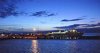
WSubic Bay is a bay on the west coast of the island of Luzon in the Philippines, about 100 kilometres (62 mi) northwest of Manila Bay. An extension of the South China Sea, its shores were formerly the site of a major United States Navy facility, U.S. Naval Base Subic Bay, now an industrial and commercial area known as the Subic Bay Freeport Zone under the Subic Bay Metropolitan Authority.
 W
WTayabas Bay is a large bay in the southern part of Luzon island in the Philippines. Several islands are located in the bay, largest of which is Marinduque.