 W
WBeaver Lake is a man-made reservoir in the Ozark Mountains of Northwest Arkansas and is formed by a dam across the White River. Beaver Lake has some 487 miles (784 km) of shoreline. With towering limestone bluffs, natural caves, and a wide variety of trees and flowering shrubs, it is a popular tourist destination. Beaver Lake is the source of drinking water in Northwest Arkansas, which is managed, treated and sold by Beaver Water District.
 W
WThe Black River is a tributary of the White River, about 300 miles (480 km) long, in southeastern Missouri and northeastern Arkansas in the United States. Via the White River, it is part of the Mississippi River watershed. Black River Technical College is named for the river.
 W
WThe Buffalo River, located in Northern Arkansas, was the first National River to be designated in the United States. The Buffalo River is 153 miles (246 km) long. The lower 135 miles (217 km) flow within the boundaries of an area managed by the National Park Service, where the stream is designated the Buffalo National River. The river flows through Newton, Searcy, Marion, and Baxter Counties, from west to east. The river originates in the highest part of the Boston Mountains of the Ozarks, flows out onto the Springfield Plateau near the historic community of Erbie, and finally crosses a portion of the Salem Plateau just before joining the White River. The Park is home to the state's only elk herd. The upper section of the river in the Ozark National Forest is managed by the U.S. Forest Service and is designated as a National Scenic River and a National Wild River; that section is not part of the area managed as a park by the Park Service but is managed as a part of the Ozark National Forest.
 W
WBull Shoals Lake is an artificial lake or reservoir in the Ozark Mountains of northern Arkansas and southern Missouri. It has hundreds of miles of lake arms and coves, and common activities include boating, water sports, swimming, and fishing. Nineteen developed parks around the shoreline provide campgrounds, boat launches, swim areas, and marinas.
 W
WThe Current River forms in the southeastern portion of the Ozarks of Missouri and becomes a 7th order stream as it flows southeasterly out of the Ozarks into northeastern Arkansas where it becomes a tributary of the Black River, which is a tributary of the White River, a tributary of the Mississippi River. The Current River is approximately 184 miles (296 km) long and drains about 2,641 square miles (6,840 km2) of land mostly in Missouri and a small portion of land in northeastern Arkansas. The headwaters of the Current River are nearly 900 feet (270 m) above sea level, while the mouth of the river lies around 280 feet (85 m) above sea level. The basin drains a rural area that is dominated by karst topography, underlain by dolomite and sandstone bedrock with a small area of igneous rock southeast of Eminence, Missouri. The annual daily mean discharge of the river near Doniphan, Missouri is 2,815 cubic feet (79.7 m3) per second. In 1964, over 134 mi (160 km) of the upper course of the river and its tributaries were federally protected as the Ozark National Scenic Riverways, the first national park in America to protect a river system.
 W
WThe Eleven Point National Wild and Scenic River is a 44-mile (71 km) stretch of the spring-fed Eleven Point River in the Ozarks of southern Missouri set aside through eminent domain for preservation by Congress in 1968. The designated part of the river stretches from Thomasville to State Highway 142. The river was included in the original proposal for the Ozark National Scenic Riverways, but it was ultimately excluded when the Riverways were designated on the Current and Jacks Fork rivers in 1964.
 W
WThe Eleven Point River is a 138-mile-long (222 km) river in southern Missouri and northern Arkansas, United States. It originates near Willow Springs, Missouri. It more than doubles in flow when Greer Spring Branch runs into it, adding over 200 million US gallons (760,000 m3) of water per day to the river. The name derives from the Mississippi Valley French word pointe, which is a wooded point of land marking a river bend. Voyageurs marked distance by counting these points of land or river bends. The river flows into the Spring River southwest of Pocahontas near the small town of Black Rock.
 W
WThe Gasconade River is about 280 miles (450 km) long and is located in central and south-central Missouri.
 W
WGrand Lake o' the Cherokees is situated in Northeast Oklahoma, nestled in the foothills of the Ozark Mountain Range. It is often simply called Grand Lake. It is administered by the Grand River Dam Authority (GRDA).
 W
WJacks Fork is one of two rivers in Missouri that are part of the Ozark National Scenic Riverways system.
 W
WThe James River is a 130-mile-long (210 km) river in southern Missouri. It flows from northeast Webster County until it is impounded into Table Rock Lake. It is part of the White River watershed. The river forms Lake Springfield and supplies drinking water for the city of Springfield.
 W
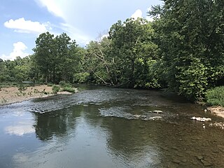
WThe Kings River is a tributary of the White River. It rises in the Boston Mountains of Arkansas and flows northward for more than 90 miles into Table Rock Lake in Missouri. The Arkansas portion of the river is undammed and bordered by rural and forested land, the river is popular for paddling and sport fishing.
 W
WLake of the Ozarks is a reservoir created by impounding the Osage River in the northern part of the Ozarks in central Missouri. Parts of three smaller tributaries to the Osage are included in the impoundment: the Niangua River, Grandglaize Creek, and Gravois Creek. The lake has a surface area of 54,000 acres (220 km2) and 1,150 miles (1,850 km) of shoreline. The main channel of the Osage Arm stretches 92 miles (148 km) from end to end. The total drainage area is over 14,000 square miles (36,000 km2). The lake's serpentine shape has earned it the nickname "Puff The Magic Dragon", which has in turn inspired the names of local institutions such as The Magic Dragon Street Meet.
 W
WThe Meramec River, sometimes spelled Maramec River is one of the longest free-flowing waterways in the U.S. state of Missouri, draining 3,980 square miles (10,300 km2) while wandering 218 miles (351 km) from headwaters near Steelville to where it empties into the Mississippi River near St. Louis at Arnold and Oakville. The Meramec watershed covers six Missouri Ozark Highland counties—Dent, Phelps, Crawford, Franklin, Jefferson, and St. Louis—and portions of eight others—Maries, Gasconade, Iron, Washington, Reynolds, St. Francois, Ste. Genevieve, and Texas. Between its source and its mouth, it falls 1,025 feet (312 m). Year-round navigability begins above Maramec Spring, just south of St. James. The Meramec's size increases at the confluence of the Dry Fork, and its navigability continues until the river enters the Mississippi at Arnold, Missouri.
 W
WThe Osage River is a 276-mile-long (444 km) tributary of the Missouri River in central Missouri in the United States. The eighth-largest river in the state, it drains a mostly rural area of 15,300 square miles (40,000 km2). The watershed includes an area of east-central Kansas and a large portion of west-central and central Missouri, where it drains northwest areas of the Ozark Plateau.
 W
WPomme de Terre Lake is located in southwest Missouri at the confluence of Lindley Creek and the Pomme de Terre River. The lake is located in southern Hickory and northern Polk counties, about 50 miles (80 km) north of Springfield. Its name is the French language word for potato.
WThe Pomme de Terre River is a 130-mile-long (210 km) tributary of the Osage River in southwestern Missouri in the United States. Via the Osage and Missouri rivers, it is part of the watershed of the Mississippi River.
 W
WThe Sac River is a river in the Ozarks of Southwest Missouri. It is 118 miles (190 km) long, with headwaters in western Greene County. The stream passes through the northeast corner of Lawrence County then re-enters Greene County. The stream enters Dade County northwest of Ash Grove. The stream enters Stockton Lake in Dade County between Dadeville and Greenfield, then flows north exiting Stockton Lake in Cedar County. The stream meanders north into St. Clair County, passes under US Route 54 and enters the Osage River in Truman Reservoir southeast of Osceola.
 W
WThe South Fork Spring River is a tributary of the Spring River, roughly 75 mi (121 km) long, in southern Missouri and northern Arkansas in the United States. The river flows through the Salem Plateau of the Ozarks and it is part of the Spring River Tributaries Watershed.
 W
WThe Spring River is a 129-mile-long (208 km) waterway located in southwestern Missouri, southeastern Kansas, and northeastern Oklahoma. The head of Spring River is a spring south of Verona just south of Highway 60 which crosses it. The stream meanders through Verona northwest and turns west across Lawrence and Jasper counties. It passes through Carthage, before crossing into Cherokee County, Kansas, where it widens considerably. It flows past the east sides of Riverton and Baxter Springs before emptying into the Grand Lake o' the Cherokees in Ottawa County, Oklahoma.
 W
WLake Springfield is a 318-acre artificial cooling lake located in Springfield, Missouri created for the James River Power Plant. It was built by placing a dam on the James River. It now serves as a popular fishing and recreation area. It is one of three fishing lakes in the city of Springfield, the others are Fellows Lake and Valley Water Mill Pond.
 W
WThe St. Francis River is a tributary of the Mississippi River, about 426 miles (686 km) long, in southeastern Missouri and northeastern Arkansas in the United States. The river drains a mostly rural area and forms part of the Missouri-Arkansas state line along the western side of the Missouri Bootheel.
 W
WStockton Lake is a reservoir located in southeastern Cedar County, northeastern Dade County, and southwestern Polk County, Missouri. The lake is 'V' shaped, and covers 39 square miles (100 km2), with 298 miles (480 km) of shoreline. It has three marinas, and 10 public-use areas. It has a "non-development policy," and is surrounded by unspoiled, tree-covered hills. Its banks are owned and operated by the Army Corps of Engineers.
 W
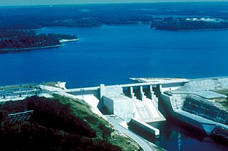
WTable Rock Lake, designed, built and operated by the U.S. Army Corps of Engineers, is an artificial lake or reservoir in the Ozarks of southwestern Missouri and northwestern Arkansas. The lake is impounded by Table Rock Dam, constructed from 1954 to 1958 on the White River by the U.S. Army Corps of Engineers.
WLake Taneycomo is a man-made lake or reservoir on the White River in the Ozark Mountains of Taney County, Missouri. The reservoir is named for the county in which it is located: Taney County, MO.
WThe Harry S. Truman Reservoir is located in the state of Missouri, United States. It is located between Clinton and Warsaw, on the Osage River and extends south to Osceola. The dam is located in Benton County, but the reservoir also extends into parts of Henry, St. Clair, and Hickory counties.
 W
WWar Eagle Creek is a stream in Benton, Washington and Madison counties of northwest Arkansas, United States, that is a tributary of the White River.
 W
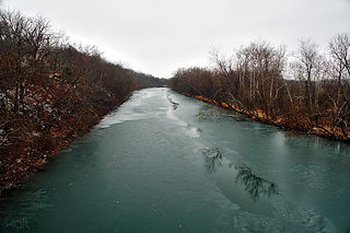
WThe White River is a 722-mile (1,162 km) river that flows through the U.S. states of Arkansas and Missouri. Originating in the Boston Mountains of northwest Arkansas, it arcs northwards through southern Missouri before turning back into Arkansas, flowing southeast to its mouth at the Mississippi River.