 W
WThe Baliem Valley [balim] is a valley of the highlands in Western New Guinea, Indonesia occupied by the Dani people. The main town in the valley is Wamena, which lies on the Baliem River. The valley is about 80 km in length by 20 km in width and lies at an altitude of about 1,600–1,700 metres (5,200–5,600 ft), with a population of over 200,000.
 W
WBiak is a small island located in Cenderawasih Bay near the northern coast of Papua, an Indonesian province, and is just northwest of New Guinea. Biak is the largest island in its small archipelago, and has many atolls, reefs, and corals.
 W
WThe Schouten Islands are an island group of Papua province, eastern Indonesia in the Cenderawasih Bay 50 km off the north-western coast of the island of New Guinea. The group consists of the main islands of Biak, Supiori and Numfor, and numerous smaller islands, mostly covered in rain forest.
 W
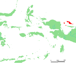
WBras Island, also known as Berasi, is an Indonesian island in the Pacific Ocean. It is one of two main islands of Mapia Atoll, the other being Pegun Island.
 W
WCape Kombies is a cape on the southwestern coast of New Guinea, near Yos Sudarso Island, in Papua Province, New Guinea.
 W
WCenderawasih Bay, also known as Sarera Bay and formerly Geelvink Bay, is a large bay in northern Province of Papua and West Papua, New Guinea, Indonesia.
 W
WThe Cyclops Mountains are located to the west of Jayapura in Papua, Indonesia, and north of Lake Sentani.
WFanildo Island is a small island in Mapia Atoll and is one of the 92 officially listed outlying islands of Indonesia. It is located in Supiori Regency of Papua province, Indonesia.
 W
WThe Foja Mountains are located just north of the Mamberamo river basin in Papua, Indonesia. The mountains rise to 2,193 metres (7,195 ft), and have 3,000 square kilometres of old growth tropical rainforest in the interior part of the range. The Foja forest tract covers 9,712 square kilometers and is the largest tropical forest without roads in the Asia Pacific region.
WCenderawasih Bay, also known as Sarera Bay and formerly Geelvink Bay, is a large bay in northern Province of Papua and West Papua, New Guinea, Indonesia.
WThe Schouten Islands are an island group of Papua province, eastern Indonesia in the Cenderawasih Bay 50 km off the north-western coast of the island of New Guinea. The group consists of the main islands of Biak, Supiori and Numfor, and numerous smaller islands, mostly covered in rain forest.
 W
WHalmahera Sea is a regional sea located in the central eastern part of the Australasian Mediterranean Sea. It is centered at about 1°S and 129°E and is bordered by the Pacific Ocean to the north, Halmahera to the west, Waigeo and West Papua to the east, and the Seram Sea to the south. It covers about 95,000 km (59,000 mi) and its topography comprises a number of separate basins and ridges, the chief of which is the Halmahera Basin reaching a depth of 2039 m.
WIlaga is the name of a small town and a farming valley in Papua, Indonesia, with an elevation of 2,286 m (7,500 ft). It is also the capital of a government district (kecamatan) of the same name, and of the newly created (2008) Puncak Regency. Most of the residents of the area belong to the Western Dani tribe. It has a small airport and a tiny community of non-Papuan traders and government officials from other parts of Indonesia. A river of the same name runs through the valley, and is a tributary of the Ilorong. The valley lies about midway between the Enarotali and Baliem valleys.
 W
WKomoran or Komolom is an island just south of the much larger Yos Sudarso near the south coast of New Guinea in Papua province, Indonesia. Its area is 695 km².
 W
WLake Sentani is a tropical, shallow, and at low-altitude open lake located at the northeast extremity of the Jayapura Regency in the Indonesian province of Papua, about 20 kilometres (12 mi) from the provincial capital, Jayapura City. It is located just to the south of the town of Sentani.
WMapia Atoll, historically known as the Freewill Islands or San David, is an atoll in the Pacific Ocean. It is located in Papua province of Indonesia, approximately 290 kilometers north of the city of Manokwari and 630 kilometers from the islands of Palau. It consists of two main islands, Bras (Berasi) and Pegun (Mapia), the smaller Fanildo, and two minor islands, Bras Kecil and Fanildo Kecil. The islands constitute a part of Supiori Regency, Papua.
 W
WMios Num is an island of the Yapen Islands group, in Papua Province of Western New Guinea, northeastern Indonesia.
WMios Woendi island is in the Schouten Islands and was the location of a forward base of the United States Navy during World War II code named "Stinker". The island is in an atoll southeast of Biak, off the north coast of Papua. It is roughly a triangle in shape with the longest side a mile in length. Padaido lagoon at Mios Woendi, provides a deep water anchorage of nearly 5 square miles while the island has 2,100 feet of navigable beach front. The climate is tropical, with an annual rainfall close to 100 inches. The people are primarily Melanesian.
WNumfor is one of the Schouten Islands in Papua province, Western New Guinea, northeastern Indonesia.
WPegun Island, also known as Mapia, is an Indonesian island in the Pacific Ocean. It is the southernmost island of Mapia Atoll, and one of two main islands in the atoll, the other being Bras Island.
WThe Schouten Islands are an island group of Papua province, eastern Indonesia in the Cenderawasih Bay 50 km off the north-western coast of the island of New Guinea. The group consists of the main islands of Biak, Supiori and Numfor, and numerous smaller islands, mostly covered in rain forest.
WSebakor Bay, is a bay on the west of Bomberai Peninsula in northern Province of Papua.
 W
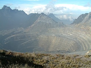
WThe Sudirman Range or Dugunduguoo or Nassau Range is a mountain range in Papua province, Indonesia. It is named after the first armed forces commander-in-chief and Indonesian national hero Sudirman. It comprises a western portion of the Maoke Mountains. The highest peak in Oceania and Australasia, Puncak Jaya, is located here, as well as the large Grasberg copper and gold mine, operated by the Freeport company based out of the United States. Other peaks of the Sudirman Range are:Sumantri Ngga Pulu Carstensz East
WSupiori is an island of the Schouten Islands archipelago in Cenderawasih Bay, just west of Biak island in Papua Province, Western New Guinea, northeastern Indonesia.
 W
WTanahmerah Bay, or Tanah Merah Bay, is a bay on the north coast of New Guinea, in the Indonesian province of Papua, about 50 km northwest of the provincial capital of Jayapura.
 W
WYapen is an island of Papua, Indonesia. The Yapen Strait separates Yapen and the Biak Islands to the north. It is in Cenderawasih Bay off the north-western coast of the island of New Guinea. To the west is Mios Num Island across the Mios Num Strait, and to the east Kurudu Island. Off the southeast coast of Yapen are the Amboi Islands and to the southwest are the Kuran Islands. It is populated with communities of Yobi, Randowaya, Serui, and Ansus. Its highest point is 1,496 metres.
 W
WYos Sudarso Bay, until 1968 known as Humboldt Bay, is a small bay on the north coast of New Guinea, about 50 kilometers west of the border between Indonesia's province of Papua and the country of Papua New Guinea. The Indonesian provincial capital Jayapura is situated on the bay.
 W
WPulau Yos Sudarso or Pulau Dolok is an island separated only by the narrow Muli Strait from the main island of New Guinea. It is part of the Merauke Regency, in the Indonesian province of Papua. The island is leaf-shaped, about 165 km (103 mi) long with an area of 11,740 km2 (4,530 sq mi). It was known as Frederik Hendrik Island until 1963. Local and alternative names of the island include Dolok, Kimaam and Kolepom.