 W
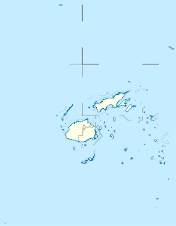
WThe Lau Islands of Fiji are situated in the southern Pacific Ocean, just east of the Koro Sea. Of this chain of about sixty islands and islets, about thirty are inhabited. The Lau Group covers a land area of 188 square miles, and had a population of 10,683 at the most recent census in 2007. While most of the northern Lau Group are high islands of volcanic origin, those of the south are mostly carbonate low islands.
 W
WCicia is a Fijian island of the Lau Group. One of the Northern Lau Islands, Cicia is volcanic and is composed of raised coral. Its area is 34 square kilometres (13 sq mi).
WCicia Airport is an airport serving Cicia, one of the Lau Islands in the Eastern Division of Fiji. It is operated by Airports Fiji Limited.
 W
WFulaga is a crescent-shaped reef-limestone island in Fiji's Southern Lau Group.
WKabara is an island of Fiji, a member of the Lau archipelago. With a land area of 31 km2 (12 sq mi), its population of some 700 lives in four villages.
 W
WKanacea (Kanathea) is a volcanic island with seven peaks in Fiji's Lau archipelago. It is 15 km west of Vanua Balavu. Covering an area of 12.48 square kilometres, it has a maximum elevation of 259 meters.
 W
WLakeba is an island in Fiji’s Southern Lau Archipelago; the provincial capital of Lau is located here. The island is the tenth largest in Fiji, with a land area of nearly 60 square kilometers. It is fertile and well watered, and encircled by a 29-kilometer road. Its closest neighbors are Aiwa and Nayau. Separated by deep sea from the latter but only by shallow waters from the former, when sea levels were lower during glacial episodes Lakeba and Aiwa formed one large island.
WLakeba Airport is an airport in Lakeba, one of the Lau Islands in southern Fiji. It is operated by Airports Fiji Limited.
 W
WThe blue-crowned lorikeet, also known as the blue-crowned lory, blue-crested lory, Solomon lory or Samoan lory, is a parrot found throughout the Lau Islands (Fiji), Tonga, Samoa, Niue and adjacent islands, including: ʻAlofi, Fotuhaʻa, Fulago, Futuna, Haʻafeva, Niuafoʻou, Moce, Niue, Ofu, Olosega, Samoa, Savaiʻi, Tafahi, Taʻu, Tofua, Tonga, Tungua, ʻUiha, ʻUpolu, Varoa, Vavaʻu, and Voleva. It is a 19 cm green lorikeet with a red throat, blue crown, and belly patch shading from red at the top to purple at the bottom.
 W
WMago Island is a volcanic island that lies in the northwest sector of Fiji's northern Lau Group of islands. One of the largest private islands in the southwestern Pacific Ocean, the pristine island consists of 22 square kilometres (8.5 sq mi) of land. The island is privately owned by actor/director Mel Gibson.
WMatuku is a volcanic island in the Moala subgroup of Fiji's Lau archipelago. Located at 19.18° South and 179.75° East, Matuku covers an area of 57 square kilometers. It has a maximum elevation of 385 meters. Matuku is part of a group of islands known as Yasayasa Moala.
WMoala Airport is an airport serving Moala, the main island of the Moala Islands, a subgroup of the Lau Islands in Fiji. It is operated by Airports Fiji Limited.
 W
WMoala is a volcanic island in the Moala subgroup of Fiji's Lau archipelago. It has an area of 62.5 square kilometers (24.1 sq mi), making it the ninth largest island of Fiji. The highest point on the island of Moala, at a maximum elevation of 468 meters (1,535 ft), is called Delaimoala which has rich vegetation and consists of dark thick forest. The population of around 3000 live in eight villages. The chiefly village of these is Naroi, whose population is over 500. Economic activities include coconut farming, cocoa production, fishing and yaqona (kava) production.
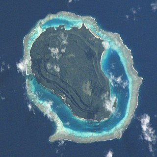
WNaitaba Island is an island of the northern Lau Islands of Fiji. It is a triangular shaped island approximately 2.4 km (1.5 mi) in diameter. The island is volcanic with coral and rises to 186 metres (610 ft) on a flat-topped hill toward the southern end of the island. The island is forested and coconuts were grown commercially for copra. There is a barrier reef completely surrounding the island.
 W
WNayau is an island of Fiji, a member of the Lau archipelago. Nearby cities: Suva; Nuku'Alofa;
 W
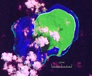
WOgea Driki is a coral atoll covering approximately 4 square kilometres in Fiji's Southern Lau Group. It is 2.7 kilometres (1.7 mi) south of Ogea Levu and 10 kilometres (6.2 mi) east of Fulaga.
WOlorua is an uninhabited island of the Lau Archipelago in the Eastern Division of Fiji. The island has an area of 0.3 square kilometres and rises to 50 metres (164 ft) above sea level. It is located 8.0 nautical miles northwest of Komo, the nearest inhabited island. It is occasionally visited by local tribes.
 W
WOno-i-Lau is a group of islands within a barrier reef system in the Fijian archipelago of Lau Islands. There are four central volcanic islands: Onolevu, Doi Lovoni and Ndavura, the uppermost parts of the volcanic edifice rising from the Lau Ridge slightly more than 1,000 metres below sea level and on which the reef and other islands are built. There are also three clusters of coral limestone islets, Yanuya and Mana on the barrier reef and Niuta. A sand cay, Udui, is not counted as one of the six “islands”.
 W
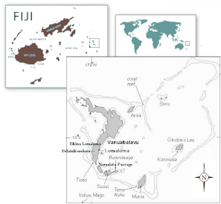
WSawana is a village on the Fijian island of Vanua Balavu, in the Lau archipelago and is part of the Tikina of Lomaloma.
 W
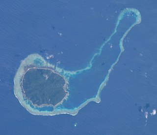
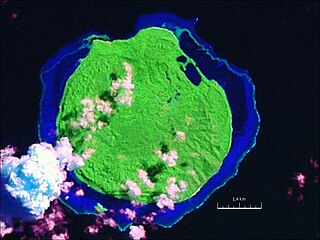
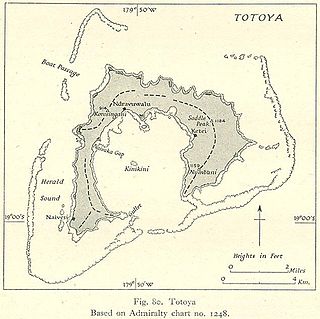
WTotoya is a volcanic island in the Moala subgroup of Fiji's Lau archipelago. It occupies an area of 28 km², making it the smallest of the Yasayasa Moala Group. Its maximum elevation is 366 metres above sea level. The main economic activity is coconut farming.
 W
WTuraga na Rasau is a traditional Fijian chiefly title of the Lau Islands. Prior to Fiji's colonial days, Fiji had many different Vanua with their own Paramount Chieftain which exercised no authority over the other; a saying from the island of Kadavu aptly summarises it "Nomu Turaga o sega na noqu Turaga" or "Your Chief is not my Chief" also the people of Beqa Island were of a similar opinion saying "Qali Cuva Ki Lagi" or "Subject only to heaven" and would bow to no outside Chieftain, but at the turn of the 20th century aspects of the traditional social structure remained, but for administrative purposes three main Matanitu were solidified and formed as they were the dominant consolidated powers at the time being that of Kubuna, Burebasaga and Tovata. With regard to the Rasau while its traditional origins were in Kubuna on Bau the titles traditional authority in modern Fiji is now in Tovata, Lau in particular Lomaloma Tikina on the Island of Vanua Balavu.
 W
WTuvana-i-Colo is an uninhabited atoll in the southeastern part of the island state of Fiji in the Pacific Ocean. It is the second most southern atoll of the Lau archipelago and represents Fiji's third most southern landmass. It is located about 25 km south of Ono-i-Lau, the southernmost inhabited Fijian atoll, and 8 kilometres east-northeast of the neighboring atoll Tuvana-i-Ra. It is completely surrounded by a fringing reef.
WTuvana-i-Ra is an uninhabited atoll in the southeastern part of the island state of Fiji in the Pacific Ocean. It is the southernmost atoll of the Lau archipelago and represents Fiji's second-southernmost landmass; only the remote and uninhabited atoll Ceva-i-Ra lies slightly further south.
 W
WTuvuca is a small island off Vanua Balavu in Fiji's Lau archipelago, it is a densely wooded and inhabited island and rises 800 feet above sea level at the highest point. There is only one village on the island. Tuvuca has untapped deposits of phosphate.
WVanua Balavu is the third largest island in Fiji's Lau archipelago, and the main island of the Northern Lau Group.
 W
WVatoa is an outlier of Fiji's Lau Group.
 W
WVatu Vara Island is a Fijian island in the northwest sector of the Lau Group of islands.
WWailagi Lala is the northernmost outpost of Fiji's Lau Islands. This tiny atoll, with an area of just 30 hectares and rising no more than 3 metres (10 ft) above mean sea level, is situated at 16.45° South and 179.6° West. It is the only true atoll in Fiji.