 W
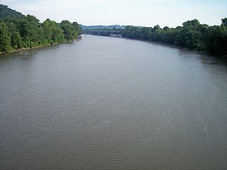
WThe Muskingum River is a tributary of the Ohio River, approximately 111 miles (179 km) long, in southeastern Ohio in the United States. An important commercial route in the 19th century, it flows generally southward through the eastern hill country of Ohio. Via the Ohio, it is part of the Mississippi River watershed. The river is navigable for much of its length through a series of locks and dams.
 W
WBeverly is a village in Washington County, Ohio, United States. It is part of the Parkersburg-Marietta-Vienna, WV-OH Metropolitan Statistical Area. The population was 1,313 at the 2010 census.
 W
WConesville is a village in Coshocton County, Ohio, United States, along the Muskingum River. The population was 347 at the 2010 census.
 W
WConotton Creek is a tributary of the Tuscarawas River, 38.7 miles (62.3 km) long, in eastern Ohio in the United States. Via the Tuscarawas, Muskingum and Ohio Rivers, it is part of the watershed of the Mississippi River, draining an area of 286 square miles (741 km²) in Carroll, Harrison and Tuscarawas County, Ohio. The source is at 1240 feet and the mouth is at 874 feet. Dover Dam, downstream on the Tuscarawas river, is normally dry, but can impound a reservoir on Conotton and tributaries to a pool elevation of 916 feet for downstream flood control by the Corps of Engineers. From its source in eastern Harrison County, Ohio the creek flows west northwest through Jewitt, Scio, Conotton, Bowerston, Leesville, Sherrodsville, New Cumberland and Somerdale before reaching its mouth in central Tuscarawas County, Ohio. The Wheeling and Lake Erie Railway is situated in the valley. Ohio State Route 151 runs in the valley from near the source to Bowerston. Ohio State Route 212 run along the valley from Bowerston to the mouth. The Conotton Creek Trail runs from Bowerston to Jewett.
 W
WCoshocton is a city in and the county seat of Coshocton County, Ohio, United States approximately 63 mi (102 km) ENE of Columbus. The population was 11,216 at the 2010 census. The Walhonding River and the Tuscarawas River meet in Coshocton to form the Muskingum River.
 W
WDevola is a census-designated place (CDP) in Washington County, Ohio, United States, along the Muskingum River. It is part of the Parkersburg-Marietta-Vienna, WV-OH Metropolitan Statistical Area. The population was 2,771 at the 2000 census.
 W
WDresden is a village in Jefferson and Cass townships in Muskingum County, Ohio, United States, along the Muskingum River at the mouth of Wakatomika Creek. It was incorporated on March 9, 1835. The population was 1,529 at the 2010 census.
 W
WHarmar is a historic neighborhood in the city of Marietta, Ohio, United States. Located at the western side of the confluence of the Muskingum and Ohio Rivers, it grew up around the early Fort Harmar in the 1780s, being settled in conjunction with Marietta. After a period of forming part of Marietta, it existed separately beginning in 1837 before rejoining the mother city in 1890. Connected by bridge to the rest of the city, it retains much of its nineteenth-century architecture and landscape, and most of the neighborhood is now a historic district on the National Register of Historic Places.
 W
WHuff Run is a 9.9 mile (15.9 km) long tributary of the Conotton Creek in eastern Ohio within Sandy Township and Rose Township. Conotton Creek is a tributary of the Ohio River via the Tuscarawas River and the Muskingum River. Mineral City is the only incorporated town within the Huff Run Watershed.
 W
WThe Licking River is a tributary of the Muskingum River, about 40 mi (65 km) long, in central Ohio in the United States. Via the Muskingum and Ohio Rivers, it is part of the watershed of the Mississippi River.
 W
WLowell is a village in Washington County, Ohio, United States, along the Muskingum River. The population was 549 at the 2010 census.
 W
WMalta is a village in Morgan County, Ohio, United States. The population was 671 at the 2010 census.
 W
WMarietta is a city in, and the county seat of, Washington County, Ohio, United States. During 1788, pioneers to the Ohio Country established Marietta as the first permanent settlement of the new United States in the Territory Northwest of the River Ohio. Marietta is located in southeastern Ohio at the mouth of the Muskingum River at its confluence with the Ohio River 11 miles northeast of Parkersburg, West Virginia. The population was 14,085 at the 2010 census.
 W
WMcConnelsville is a village in Morgan County, Ohio, United States located 21 miles southeast of Zanesville and 26 miles northwest of Marietta. The population was 1,784 at the 2010 census. It is the county seat of Morgan County. As of October 19, 2011, the mayor is John Walter Finley.
 W
WMoxahala Creek is a tributary of the Muskingum River, 29.2 miles (47.0 km) long, in southeastern Ohio in the United States. Via the Muskingum and Ohio Rivers, it is part of the watershed of the Mississippi River, draining an area of 301 square miles (780 km2)
 W
WNorth Zanesville is a census-designated place (CDP) in Muskingum County, Ohio, United States, just north of the city of Zanesville, along the Muskingum River. The population was 3,013 at the 2000 census.
 W
WPhilo is a village in Muskingum County, Ohio, United States, along the Muskingum River. The population was 733 at the 2010 census.
 W
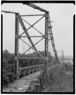
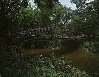
WThe Putnam Street Bridge, also known as the Marietta Bridge, is a historic United States river crossing that connects Marietta, Ohio, with its Fort Harmar district. The original 1880 bridge was the first free crossing of the Muskingum River. The 1913 bridge was a contributing structure to the Harmar Historic District. The bridge crosses the Muskingum, just above its confluence with the Ohio River.
 W
WSandy Creek is a tributary of the Tuscarawas River, 41.3 miles (66.5 km) long, in northeastern Ohio in the United States. Via the Tuscarawas, Muskingum and Ohio Rivers, it is part of the watershed of the Mississippi River, draining an area of 503 square miles (1,303 km²).
 W
WSouth Zanesville is a village in Muskingum County, Ohio, United States, along the Muskingum River at the mouth of Moxahala Creek. The population was 1,989 at the 2010 census.
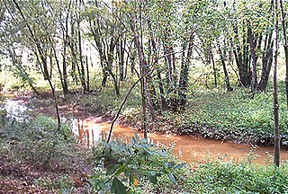
Still Fork is a tributary of the Sandy Creek, 16.1 miles (26 km) long, in eastern Ohio in the United States. Via the Sandy Creek, Tuscarawas, Muskingum and Ohio Rivers, it is part of the watershed of the Mississippi River, draining an area of 71.4 square miles (185 km2) in Carroll County, Ohio. The source is at 1,180 feet (360 m) and the mouth is at 1,027 feet (313 m)., with an average gradient of only 0.2%. From its source in eastern Carroll County the creek flows northwest through Fox, Washington, Augusta, and Brown Townships before reaching its mouth in Minerva, Ohio. The Ohi-Rail Corporation (OHIC) and Arbor road are situated in the creeks valley over most of its length.
 W
WStockport is a village in Morgan County, Ohio, United States, along the Muskingum River. The population was 503 at the 2010 census.
 W
WThe Tuscarawas River is a principal tributary of the Muskingum River, 129.9 miles (209 km) long, in northeastern Ohio in the United States. Via the Muskingum and Ohio rivers, it is part of the watershed of the Mississippi River, draining an area of 2,590 square miles (6,700 km2) on glaciated and unglaciated portions of the Allegheny Plateau.
 W
WWakatomika Creek is a tributary of the Muskingum River, 42.6 mi (68.6 km) long, in central Ohio in the United States. Via the Muskingum and Ohio Rivers, it is part of the watershed of the Mississippi River, draining an area of 234 mi² (606 km²)
 W
WThe Walhonding River is a principal tributary of the Muskingum River, 23.5 miles (37.8 km) long, in east-central Ohio in the United States. Via the Muskingum and Ohio Rivers, it is part of the watershed of the Mississippi River. It drains an area of 2,252 square miles (5,830 km2).
 W
WWills Creek is a tributary of the Muskingum River, 92.2 mi (148.4 km) long, in eastern Ohio in the United States. Via the Muskingum and Ohio Rivers, it is part of the watershed of the Mississippi River. It drains an area of 853 mi² (2,209 km²).
 W
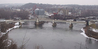
WThe Zanesville Y-Bridge is a historic Y-shaped three-way bridge that spans the confluence of the Licking and Muskingum Rivers in downtown Zanesville, Ohio. It carries the traffic of U.S. Route 40, as well as Linden Avenue.
 W
WZanesville is a city in and the county seat of Muskingum County, Ohio, United States. It is located 52 miles (84 km) east of Columbus. The population was 25,487 as of the 2010 census. Zanesville anchors the Zanesville Micropolitan Statistical Area and is part of the Columbus-Marion-Zanesville Combined Statistical Area