 W
WAstrolabe Reef is near Motiti Island, 20 kilometres NE of Tauranga, off the Bay of Plenty coast in New Zealand. The reef, which breaks the water surface at low tide, is a renowned scuba diving spot that drops off to 37 metres (121 ft) in different parts. The reef was named by Jules Dumont d'Urville after his ship Astrolabe, when it nearly ran aground there on 16 February 1827.
 W
WBeveridge Reef is a submerged atoll located in the Exclusive Economic Zone of Niue, approximately 130 miles from Niue and 600 miles from the Cook Islands. The reef is normally submerged, with a small part visible at low tide. It has been the cause of several fishing boats running aground.
 W
WBligh Reef, sometimes known as Bligh Island Reef, is a reef off the coast of Bligh Island in Prince William Sound, Alaska. This was the location of the 1989 Exxon Valdez oil spill. After the incident, US Code 33 § 2733 mandated the operation of an automated navigation light to prevent future collisions with the reef. Despite these efforts the tug Pathfinder ran aground on Bligh Reef on Dec 24, 2009, rupturing its tanks and spilling diesel fuel. Bligh Reef is also where Alaska Steamship Company's Olympia ran aground in 1910.
 W
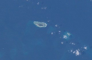
WClipperton Island is an uninhabited 6 km2 (2.3 sq mi) coral atoll in the eastern Pacific Ocean off the coast of Central America. It is 10,677 km (6,634 mi) from Paris, France, 5,400 km (2,900 nmi) from Papeete, Tahiti, and 1,080 km (580 nmi) from Mexico. It is an overseas state private property of France, under direct authority of the Minister of Overseas France.
 W
WConway Reef, known since 1976 by its Fijian name Ceva-I-Ra Reef,, is a coral reef of atoll type 450 km southwest of the Fiji Islands and part of the Republic of Fiji. It is at 21°44′18″S 174°38′24″E. It is 2.5 km long in an east–west direction. On the middle of the reef is a small sand cay, 1.8 meters high and about 320 metres long and 73 metres wide, with a land area of two hectares. A stranded wreck of a coaster lies 240 metres south of the centre of the cay, and the wreck of a fishing vessel lies on the northeast end of the reef. The reef is uninhabited apart from birds which appear to have almost no fear of humans. Administratively, the reef is part of the Western Division, Fiji and of the Nadroga-Navosa province.
 W
WThe Ernest Legouve Reef is located in the South Pacific, south of French Tuamotu Islands and east of New Zealand. Krauth reports that it is situated at 35°12′S 150°40′W.
 W
WFilippo Reef is a reef that is asserted to be in the Pacific Ocean at 05°30′S 151°50′W, 450 kilometres (280 mi) east of Starbuck Island in the Line Islands. The reef was reported by the master of the Italian barque Filippo as having been seen on 28 June 1886. From an unidentified report of breakers dated 1926, it was estimated to have a water depth of only 0.6 to 0.9 metres, and appeared to be about 1.6 kilometres (1.0 mi) long northwest to southeast, and less in width.
 W
WThe French Frigate Shoals is the largest atoll in the Northwestern Hawaiian Islands. Its name commemorates French explorer Jean-François de La Pérouse, who nearly lost two frigates when attempting to navigate the shoals. It consists of a 20-mile (32 km) long crescent-shaped reef, twelve sandbars, and the 120-foot (37 m) high La Perouse Pinnacle, the only remnant of its volcanic origins. The total land area of the islets is 61.508 acres (24.891 ha). Total coral reef area of the shoals is over 232,000 acres (94,000 ha). Tern Island, with an area of 26.014 acres (10.527 ha), has a landing strip and permanent habitations for a small number of people. It is maintained as a field station in the Hawaiian Islands National Wildlife Refuge by the United States Fish and Wildlife Service. The French Frigate Shoals are about 487 nautical miles northwest of Honolulu.
 W
WHaymet Rocks were reported by J.E. Haymet, master and owner of the cutter Will Watch, when on passage between Auckland and Rarotonga; in 1863 the cutter passed between two rocks and struck on the northern of the two, damaging her false keel. The rocks are said to extend over a space of about a quarter of a mile, to have been distinctly seen, and with apparently 7 or 8 feet water on them. Haymet gave their position as 27°11′S 160°13′W, which would place them about 135 miles west of the position assigned to Orne Bank.
 W
WThe Indispensable Reefs are a chain of three large coral atolls in the Coral Sea. They are located about 50 km (30 mi) south of Rennell Island, separated from it by Rennel Trough. The chain stretches over a length of 114 km (71 mi) and its average width is 18 km (11 mi).
WJupiter Reef or Jupiter Breakers is a supposed reef in the South Pacific, between other supposed reefs, Maria Theresa Reef to the south and Ernest Legouve Reef to the north; it appears to be a phantom reef.
 W
WKingman Reef is a largely submerged, uninhabited triangular-shaped reef, 9.0 nautical miles east-west and 4.5 nmi (8 km) north-south, in the North Pacific Ocean, roughly halfway between the Hawaiian Islands and American Samoa. It has an area of 3 hectares and is one of the unincorporated territories of the United States in Oceania.
 W
WLisianski Island is one of the Northwestern Hawaiian Islands, with a land area of 384.425 acres (155.571 ha) and a maximum elevation of 40 feet (12 m) above sea level. It is a low, flat sand and coral island about 905 nautical miles (1,676 km) northwest of Honolulu. The island is surrounded by reefs and shoals, including the extensive Neva Shoals. Access to the island is limited by helicopter or by boat to a narrow sandy inlet on the southeastern side of the island.
WThe Maria Theresa Reef is a supposed reef in the South Pacific ; it appears to be a phantom reef. It is also known as Tabor Island or Tabor Reef on French maps.
 W
WMaro Reef is a largely submerged coral atoll located in the Northwestern Hawaiian Islands. It was discovered in 1820 by Captain Joseph Allen of the ship Maro, after whose ship the reef was named. With a total area of 747 square miles (1,935 km2), it is the largest coral reef in the Northwestern Hawaiian Islands. It contains 37 species of stony coral. Unlike most atolls, the coral extends out from the center like spokes on a wheel. Located about 850 miles northwest of Honolulu, Hawaii, Maro Reef contains about 1 acre (4,000 m2) of dry land which itself can be submerged depending on the tides. Some scientists believe that it "may be on the verge of drowning" because the reefs are detached and are vulnerable to strong storm waves.
 W
WMarpi Reef or Marpi Bank is a narrow seamount lies 28 km (17 mi) north of Saipan. With length of 9 km (5.6 mi) and 4 km (2.5 mi) in width, the reef is generally similar to the Tatsumi Reef south of Tinian in terms of orientation in a northeast to southwest. The peak of the seamount is at 26 fathoms or 53 m under water surfaces.
 W
WMidway Atoll is a 2.4-square-mile (6.2 km2) atoll in the North Pacific Ocean at 28°12′N 177°21′W. Midway Atoll is an unorganized, unincorporated territory of the United States.
 W
WThe Minerva Reefs are a group of two submerged atolls located in the Pacific Ocean south of Fiji and Tonga.
 W
WOrford Reef is a reef located off Cape Blanco on the southern coast of Oregon in the United States. The reef is situated around eight small rock islands: Best Rock, Long Brown Rock, Unnamed Rock, Square White Rock, Seal Rock, Conical White Rock, West Conical Rock, and Arch Rock.
 W
WThe Pearl and Hermes Atoll is part of the Northwestern Hawaiian Islands, a group of small islands and atolls that form the farthest northwest portion of the Hawaiian island chain. The atoll consists of a variable number of flat and sandy islets, typically between five and seven. More were noted in historical sources but have since been lost to erosion and rising sea levels.
WThe Portland Reef is a submerged shoal not rising above the surface in the Gambier Islands in French Polynesia. It is located in the far southeast of the Tuamotu group archipelago, about 68 km southeast from the Gambier Islands, and 30 km SSE from Temoe Atoll, below the Tropic of Capricorn.
 W
WPunta Burica is a small coastal peninsula−reef extending south of the Burica Peninsula on the Pacific border between Costa Rica and Panama.
 W
WRivadeneyra Shoal is a shoal or seamount in the Eastern Pacific Ocean between Malpelo Island and Cocos Island. It was reported in October 1842 at the position 4°15′N 85°10′W with a depth of 10 feet. It was unsuccessfully searched for by the British war vessels HMS Cockatrice and HMS Havannah in 1854 and 1857 respectively, and by the USS Mohican in 1885.
 W
WSocotra Rock is a submerged rock 4.6 metres (15 ft) below sea level located in the Yellow Sea. International maritime law stipulates that a submerged rock outside of a nation's territorial sea can not be claimed as territory by any nation. However, the rock is the subject of a maritime dispute between South Korea and China, which consider it to lie within their respective exclusive economic zones.
 W
WSupply Reef is a submerged circular reef of volcanic origin in the Northern Mariana Islands chain, about 10 kilometres (6 mi) NW of the Maug Islands. Presently this igneous seamount is roughly 8 metres (26 ft) below the ocean's surface and about 100 m (300 ft) in diameter. Apparent episodes of submarine volcanism were noted on December 22-24 and 26-27 in 1989.
 W
WThe Tubbataha Natural Park also known as Tubbataha Reefs Natural Park is a protected area of the Philippines located in the middle of the Sulu Sea. The marine and bird sanctuary consists of two huge atolls and the smaller Jessie Beazley Reef covering a total area of 97,030 hectares. It is located 150 kilometres (93 mi) southeast of Puerto Princesa City, the capital of Palawan province. The uninhabited islands and reefs are part of the island municipality of Cagayancillo, Palawan, located roughly 130 kilometres (81 mi) to the northeast of the reef.
Vanderbilt Reef is a rocky outcropping in Lynn Canal, a fjord in Alaska, United States at 58°35′31″N 135°0′55″W. The outcropping is visible just above the water's surface.
WCaptain Lambert of the ship Wachusett reported that on June 4, 1899 he passed over a reef which appeared to be of coral formation in approximately latitude 32°18′S 151°08′W. The reef appeared to be about 500 feet wide. The bottom showed of a dark gray color with deep blue on both sides of the reef. The depth was estimated at from 5 to 6 fathoms; unfortunately no soundings were taken.
 W
WZhongzhou Reef also known as Ban Than Reef and Centre Cay is a small coral reef on the north edge of the Tizard Bank in the Spratly Islands, South China Sea. It lies 4.6 km (2.9 mi) east of Taiwan-administered Taiping Island, 7.2 km (4.5 mi) west of Vietnam-administered Sand Cay, and has an exposed area of approximately 0.2 hectares during high tide, and 0.6 hectares during low tide. It consists of an accumulation of seashells, sand, coral reefs and debris which forms a circular coral reef plate, surrounding the reef under the water, with a diameter of approximately 1.3 km (0.8 mi).