 W
WSan Pablo Bay is a tidal estuary that forms the northern extension of San Francisco Bay in the East Bay and North Bay regions of the San Francisco Bay Area in northern California.
 W
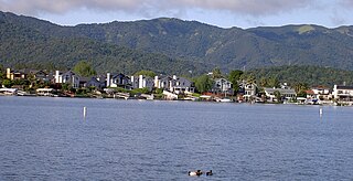
WBel Marin Keys is an unincorporated community in Marin County, California. It lies at an elevation of 10 feet.
 W
WThe Brothers are a pair of small islands, East Brother and West Brother, located in the San Rafael Bay embayment of San Pablo Bay, these roughly 1,000 feet (300 m) west of Point San Pablo in Contra Costa County, California.
 W
WThe California State University Maritime Academy is a public university in Vallejo, California. It is one of 23 campuses in the California State University system and the only maritime academy on the United States West Coast. It is located in Vallejo, California. The university offers six different Bachelor's degrees, and one Master's degree, but no Doctoral degrees.
 W
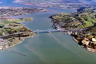
WThe Carquinez Strait is a narrow tidal strait in Northern California. It is part of the tidal estuary of the Sacramento and the San Joaquin rivers as they drain into the San Francisco Bay. The strait is eight miles (13 km) long and connects Suisun Bay, which receives the waters of the combined rivers, with San Pablo Bay, a northern extension of the San Francisco Bay.
 W
WThe Dotson Family Marsh, formerly Breuner Marsh, is a 238-acre regional park on San Pablo Bay in the East San Francisco Bay Area city of Richmond, California, In 2009 the East Bay Regional Parks District acquired the Breuner Marsh site, adding it to Point Pinole Regional Shoreline. A habitat restoration plan for 60 acres of wetlands and 90 acres of California coastal prairie was subsequently approved.
 W
WEast Brother Island Lighthouse is a lighthouse located on East Brother Island in San Rafael Bay, near the tip of Point San Pablo in Richmond, California. It marks the entrance to San Pablo Bay from San Francisco Bay.
 W
WHamilton Field was a United States Air Force base, which was inactivated in 1973, decommissioned in 1974, and put into a caretaker status with the Air Force Reserves until 1976. It was transferred to the United States Army in 1983 and was designated an Army Airfield until its BRAC closure in 1988. It is located along the western shore of San Pablo Bay in the southern portion of Novato, in Marin County, California.
WHamilton Field was a United States Air Force base, which was inactivated in 1973, decommissioned in 1974, and put into a caretaker status with the Air Force Reserves until 1976. It was transferred to the United States Army in 1983 and was designated an Army Airfield until its BRAC closure in 1988. It is located along the western shore of San Pablo Bay in the southern portion of Novato, in Marin County, California.
 W
WThe Hamilton Wetland Restoration Project, now known as the Hamilton/Bel Marin Keys Wetlands Restoration is a wetlands habitat restoration project at the former Hamilton Air Force Base—Hamilton Army Airfield (1930−1988) site and adjacent Bel Marin Keys shoreline, in Marin County, California.
 W
WHercules is a city in western Contra Costa County, California. Situated along the coast of San Pablo Bay, it is located in the eastern region of the San Francisco Bay Area, about 10 miles (16 km) north of Berkeley, California. As of 2010, its population was 24,060, according to the United States Census Bureau. The site of Hercules was first developed in 1881 as a manufacturing facility of the California Powder Works for the production of its patented dynamite formulation, Hercules powder. In 1882, the Hercules Powder Company was incorporated and assumed responsibility for the Hercules site. It was one of several explosive manufacturers that were active along the Pinole shoreline in the late 19th to the mid-20th century. The small company town that grew up near the facility subsequently became known as "Hercules", and was incorporated at the end of 1900. Starting in the 1970s, Hercules was heavily redeveloped as suburban bedroom community that lies along the I-80 corridor in Western Contra Costa County. It has a very ethnically diverse population.
 W
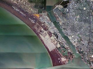
WMare Island is a peninsula in the United States in the city of Vallejo, California, about 23 miles (37 km) northeast of San Francisco. The Napa River forms its eastern side as it enters the Carquinez Strait juncture with the east side of San Pablo Bay. Mare Island is considered a peninsula because no full body of water separates this or several other named "islands" from the mainland. Instead, a series of small sloughs cause seasonal water-flows among the so-called islands. Mare Island is the largest of these at about 3.5 miles (5.6 km) long and a mile wide.
 W
WMare Island Lighthouse was a lighthouse in California, United States, on the north shore of San Pablo Bay at the entrance to Carquinez Strait, California.
 W
WThe Mare Island Naval Shipyard (MINSY) was the first United States Navy base established on the Pacific Ocean. It is located 25 miles northeast of San Francisco in Vallejo, California. The Napa River goes through the Mare Island Strait and separates the peninsula shipyard from the main portion of the city of Vallejo. MINSY made a name for itself as the premier US West Coast submarine port as well as serving as the controlling force in San Francisco Bay Area shipbuilding efforts during World War II.
 W
WThe Mare Island Strait is a channel at 38.10°N 122.265°W in the San Pablo Bay separating Mare Island and the mainland in Vallejo, California in Solano County. The strait was formerly used by the Mare Island Naval Shipyard until its closure in 1995. The strait is the mouth of the Napa River and is used for both recreational and freight boating. The Vallejo Ferry Terminal and its commuter ferry service to San Francisco are located on the strait.
 W
WThe Marin Islands are the two small islands, named East Marin and West Marin, in San Rafael Bay, an embayment of San Pablo Bay in Marin County, California.
 W
WMcNears Beach was the site of a fashionable beach resort established in the 1880s on San Pablo Bay in Marin County, California. It was located 0.5 miles (0.8 km) north-northwest of Point San Pedro, and 3.4 miles (5.4 km) northeast of San Rafael. The United States Board of Geographic Names rejected other, similar names proposed for the site, including McNear, McNear Landing, and McNear's Beach.
 W
WPinole is a city in Contra Costa County, California, United States. The population was 18,390 at the 2010 census.
 W
WPoint Pinole Regional Shoreline is a regional park on the shores of the San Pablo Bay, California, in the United States. It is approximately 2,315 acres (9.37 km2) in area, and is operated by the East Bay Regional Park District. It includes the Dotson Family Marsh and the Point Pinole Lagoon and hosts the North Richmond Shoreline Festival.
 W
WPoint San Pablo Harbor is a marina and small community at the far end of Point San Pablo in San Pablo Bay, within Richmond, in Contra Costa County, California. It is located at 1900 Stenmark Drive, Richmond CA 94801.
 W
WThe Potrero Hills also known as the Potrero Ridge and Point Molate Hills is a chaparral and forested escarpment that crests northwest to southeast along the San Pablo Peninsula in Richmond, California.
 W
WRodeo is a census-designated place (CDP) located in Contra Costa County, California, in the East Bay sub-region of the San Francisco Bay Area, on the eastern shore of San Pablo Bay, 25 miles northeast of San Francisco. The population was 8,679 at the 2010 census. The town is named for the livestock roundups common in the late 19th century. Cattle from the surrounding hills were regularly driven down through the old town to a loading dock on the shoreline of San Pablo Bay for shipment to slaughterhouses, a practice which continued through the early 20th century. The town of Rodeo is served by the Interstate 80 freeway and State Route 4. The Southern Pacific Railroad main line passes through Rodeo. Rodeo has not been a stop on the railroad since the 1950s.
 W
WThe San Francisco Bay National Estuarine Research Reserve is one of 27 reserves established as part of the United States National Estuarine Research Reserve System. The reserve is used to promote San Francisco Bay wetlands and estuary research, education, and stewardship.
 W
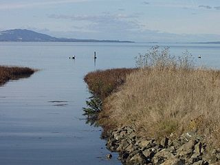
WSan Pablo Bay National Wildlife Refuge is a 13,190-acre (53.4 km2) National Wildlife Refuge in California established in 1970. It extends along the northern shore of San Pablo Bay, from the mouth of the Petaluma River, to Tolay Creek, Sonoma Creek, and ending at Mare Island.
 W
WSan Rafael Bay is an embayment of San Pablo Bay, located in Marin County and the northern San Francisco Bay Area, California.
 W
WSelby is an unincorporated community in Contra Costa County, in the East Bay region of the San Francisco Bay Area in northern California.
 W
WThe Sisters are two small rock islands in San Pablo Bay, located 500 meters (1,600 ft) northeast of Point San Pedro in Marin County, California.
 W
WVallejo Station is an inter-modal transit station in Vallejo, California. It is located at the western part of Central Vallejo and includes the Vallejo Ferry Terminal, a multi-story parking garage/paseo, and the Vallejo Transit Center bus station.
WWhiteside Marsh is a coastal estuary marsh and wetlands on the northwestern shore of San Pablo Bay in southeastern Marin County, California. It is in and adjacent to the city of Novato and the Bel Marin Keys community, in the North Bay region of the San Francisco Bay Area.