 W
WWenatchee National Forest is a U.S. National Forest located in Washington. With an area of 1,735,394 acres, it extends about 137 miles along the eastern slopes of the Cascade Range of Washington, USA from Okanogan National Forest to Gifford Pinchot National Forest. The forest is located in Chelan, Kittitas and Yakima counties.
 W
WAasgard Pass, officially identified as Colchuck Pass, is a mountain pass on the east side of the Cascades in Washington's Alpine Lakes Wilderness southwest of Leavenworth. It is the shorter and steeper of two primary hiking routes into the Enchantments, one of Washington's most popular hiking areas. It separates Colchuck Lake to the northwest from the Upper Enchantment Basin to the southeast. Aasgard Pass is located at the saddle between Dragontail Peak and the Enchantment Peaks.
 W
WThe Alpine Lakes Wilderness is a large wilderness area spanning the Central Cascades of Washington state in the United States. The wilderness is located in parts of Wenatchee National Forest and Snoqualmie National Forest, and is approximately bounded by Interstate 90 and Snoqualmie Pass to the south and U.S. Route 2 and Stevens Pass to the north. The Alpine Lakes is the largest wilderness area near the population centers of Puget Sound, counted at 414,161 acres (167,605 ha) following the 2014 expansion.
WThe Alpine Lakes Wilderness contains a number of mountain peaks and ranges:
 W
WBills Peak is a 6,917-foot (2,108-metre) mountain summit located on the common border of Kittitas County with Chelan County in Washington state. It is the tenth-highest point in the Teanaway area of the Wenatchee Mountains. Bills Peak is situated 2.6 mi (4.2 km) west-northwest of Earl Peak, its nearest higher neighbor, on the boundary of the Alpine Lakes Wilderness, on land managed by Wenatchee National Forest. Precipitation runoff from the peak drains south into tributaries of the Teanaway River, or north into tributaries of Ingalls Creek which is part of the Wenatchee River drainage basin. The view from the summit of this peak showcases the impressive Mount Stuart and Stuart Range. Bills Peak was named after William Noble "Bill" Prater (1926–2010), a mountaineer and farmer from nearby Ellensburg.
 W
WCle Elum Lake is a lake and reservoir along the course of the Cle Elum River, in Washington state USA. Cle Elum Lake is the easternmost lake of three large lakes in the Cascade Range. The middle one, Kachess Lake is also north of I-90 while the westernmost, Keechelus Lake is south of I-90.
 W
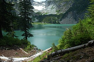
WColchuck Peak is an 8,705-foot (2,653-metre) mountain located in the Stuart Range, in the Alpine Lakes Wilderness in Chelan County of Washington state. The nearest higher peak is Dragontail Peak, 0.49 mi (0.79 km) to the east, and Argonaut Peak lies 0.9 mi (1.4 km) to the southwest. The Colchuck Glacier which lies on the northeast slopes of the peak melts into Colchuck Lake. The mountain and glacier take their name from the lake, which in Chinook jargon means "cold water". Precipitation runoff from the peak drains north into Mountaineer Creek, a tributary of Icicle Creek, or south into Ingalls Creek, all of which winds up in the Wenatchee River.
 W
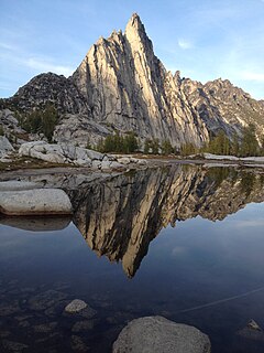
WDragontail Peak, also known as Dragon Tail, is a mountain in the Stuart Range, in Chelan County, Washington. While climbing an adjacent peak, Lex Maxwell, Bob McCall, and Bill Prater remarked that the needles on the crest, southwest of the summit, resembled a "dragon tail". The name was officially accepted in 1955. On the mountain's northeast flank lies Colchuck Lake which drains into Mountaineer Creek, and Colchuck Glacier lies below the western slopes of the peak. On its south side the mountain drops steeply to Ingalls Creek, which flows about 5,800 feet (1,800 m) below the summit.
 W
WEarl Peak is a 7,036-foot (2,145-metre) mountain summit located on the edge of the Alpine Lakes Wilderness, in Kittitas County of Washington state. Earl Peak is the eighth-highest point in the Teanaway area of the Wenatchee Mountains. It is situated two miles southwest of Navaho Peak, on land managed by Wenatchee National Forest. Precipitation runoff from the peak drains south into tributaries of the Teanaway River, or north into Hardscrabble Creek which is part of the Wenatchee River drainage basin. The view from the summit of this peak showcases the impressive Mount Stuart and Stuart Range for those who climb it.
 W
WEsmeralda Peaks is a 6,765 ft (2,060 m) multi-summit mountain located in Kittitas County of Washington state. Esmeralda Peaks are in the Teanaway area of the Wenatchee Mountains. Esmeralda Peaks is situated 2.4 mi (3.9 km) south of Ingalls Peak, and 1.7 mi (2.7 km) southeast of Hawkins Mountain, on land managed by Wenatchee National Forest. Precipitation runoff from the peaks drains into tributaries of the Teanaway River. This mountain's name has also been spelled Esmerelda Peaks, however Esmeralda was officially adopted in 1966 by the U.S. Board on Geographic Names.
 W
WFortune Peak is a 7,382-foot (2,250-metre) mountain summit located along the common border of Kittitas County and Chelan County, in Washington state. Fortune Peak is the second-highest point in the Teanaway area of the Wenatchee Mountains. It is situated 0.74 mi (1.19 km) south-southwest of Ingalls Peak, and southwest of Lake Ingalls, on the Alpine Lakes Wilderness boundary, on land managed by Wenatchee National Forest. Precipitation runoff from the peak drains northwest into Fortune Creek, a tributary of Cle Elum River; south into tributaries of Teanaway River; or east into Ingalls Creek which is part of the Wenatchee River drainage basin. This peak is unofficially named for its position at the head of Fortune Creek. This creek was where the Queen of the Hills and Ruby Mines were located. Queen of the Hills was a lode gold mine, whereas the Ruby Mine produced antimony, copper, lead, and silver with a by-product of gold.
 W
WGlacier Peak Wilderness is a 566,057-acre (229,075 ha), 35-mile-long (56 km), 20-mile-wide (32 km) wilderness area located within portions of Chelan, Snohomish, and Skagit counties in the North Cascades of Washington. The area lies within parts of Wenatchee National Forest and Mount Baker National Forest and is characterized by heavily forested stream courses, steep-sided valleys, and dramatic glacier-crowned peaks. The dominant geologic feature of the area is 10,541-foot (3,213 m) Glacier Peak. It is the most remote major volcanic peak in the Cascade Range and has more active glaciers than any other place in the lower forty-eight states. Glacier Peak is a volcanic cone of basalt, pumice, and ash which erupted during periods of heavy glaciation.
 W
WGranite Mountain is a 7,144-foot (2,177-metre) double summit mountain located 11.5 mi (18.5 km) south of Stevens Pass on the common border of Kittitas County and Chelan County in Washington state. It's part of the Wenatchee Mountains, which are a subset of the Cascade Range, and is situated 19 mi (31 km) west of Leavenworth in the Alpine Lakes Wilderness, on land managed by Okanogan-Wenatchee National Forest. Granite Mountain is the highest point on the Hyas Lake-French Creek divide with precipitation runoff from the mountain draining west into Cle Elum River, or east into French Creek, a tributary of Icicle Creek. Its subsidiary 7,080-ft South Peak is positioned half a mile to the south-southeast, the nearest higher neighbor is The Cradle, 3 mi (4.8 km) to the southeast, and Mac Peak is set 3.6 mi (5.8 km) to the north-northwest. The Pacific Crest Trail skirts below the western base this peak.
 W
WHarding Mountain is a 7,173 ft (2,190 m) mountain summit located in Chelan County of Washington state. It is the seventh-highest point in the North Wenatchee Mountains. Harding Mountain is situated within the Alpine Lakes Wilderness, 5.35 mi (8.61 km) northwest of Mount Stuart, and 4.1 mi (6.6 km) west of Eightmile Mountain, on land managed by Wenatchee National Forest. Precipitation runoff from the peak drains into tributaries of Icicle Creek, which in turn is a tributary of the Wenatchee River. This mountain was named after President Warren G. Harding by Albert Hale Sylvester.
 W
WHawkins Mountain is a 7,160+ ft double-summit massif located in Kittitas County of Washington state. Hawkins Mountain is the sixth-highest point in the Teanaway area of the Wenatchee Mountains. The lower (7,080-ft) east summit is also known as Hawkins Thimble. Hawkins is situated three miles southwest of Ingalls Peak, and 1.7 mi (2.7 km) northwest of Esmeralda Peaks, on land managed by Wenatchee National Forest. Precipitation runoff from the peak drains into tributaries of the Teanaway River and Cle Elum River. This mountain was named for prospector Samuel S. Hawkins.
 W
WThe Henry M. Jackson Wilderness is a 103,297-acre (41,803 ha) designated wilderness area in the state of Washington, United States. The area lies adjacent to the southwest corner of the Glacier Peak Wilderness, northwest of Stevens Pass on U.S. Highway 2 and northeast of the town of Skykomish, Washington. Wild Sky Wilderness is located immediately southwest of the Henry M. Jackson Wilderness. While the wilderness straddles the Cascade Mountain Range, most of it is in the westside ecotype. The wilderness lies in parts of Snoqualmie, Mount Baker, and Wenatchee national forests.
 W
WIcicle Creek is a stream in the U.S. state of Washington. It originates at Josephine Lake near the crest of the Cascade Range and flows generally east to join the Wenatchee River near Leavenworth. Icicle Creek's drainage basin is mountainous and mostly undeveloped land within the Wenatchee National Forest and the Alpine Lakes Wilderness. The final 6 miles (10 km) of the creek are moderately developed with scattered homes and pasture, a golf course, children's camp, a small housing development called Icicle Island Club, and the Leavenworth National Fish Hatchery. Some water is diverted from the creek for municipal use by the City of Leavenworth at Icicle Creek river mile 5.6. Near Leavenworth, the wheelchair-accessible Icicle Creek Nature Trail, a National Recreation Trail designated in 2005, runs 1.0 mile (1.6 km) along a historic creek channel.
 W
WIngalls Peak is a 7,662-foot (2,335-metre) triple-summit mountain located in the Alpine Lakes Wilderness, along the common border of Kittitas County and Chelan County, in Washington state. Ingalls Peak is the highest point in the Teanaway area of the Wenatchee Mountains. It is situated 2 mi (3.2 km) west of Mount Stuart, and immediately west of Lake Ingalls, on land managed by Wenatchee National Forest. Its subpeaks are the South Peak and the East Peak. Precipitation runoff from the peak drains north into Jack Creek, a tributary of Icicle Creek; west into Fortune Creek; or east into Ingalls Creek, a tributary of the Wenatchee River. This peak, the lake, creek, and pass are named for Captain Benjamin Ingalls of the United States Cavalry who led an 1855 survey of this area and is credited with discovering gold in the region.
 W
WThe Jack Creek Fire was a wildfire in the Alpine Lakes Wilderness of the Okanogan-Wenatchee National Forest in Washington, approximately 15 miles southwest of Leavenworth, Washington in the United States. It was started by a lightning strike on August 11, 2017. The fire burned a total of 4,606 acres (19 km2).
 W
WKachess Lake is a lake and reservoir along the course of the Kachess River in Washington state, US. The upper part of the lake, north of a narrows, is called Little Kachess Lake. The Kachess River flows into the lake from the north, and out from the south. Kachess Lake is the middle of the three large lakes which straddle Interstate 90 north of the Yakima River in the Cascade Range. The other two are Cle Elum Lake, the easternmost which is also north of I-90 and Keechelus Lake, the westernmost, which is south of I-90.
WKeechelus Lake is a lake and reservoir in the northwest United States, near Hyak in Kittitas County, Washington. Approximately fifty miles (80 km) southeast of Seattle and a few miles southeast of Snoqualmie Pass, it is the source of the Yakima River.
 W
WThe Lake Chelan-Sawtooth Wilderness is a 153,057-acre (61,940 ha) protected wilderness area located within the Okanogan and Wenatchee national forests in Washington State. The wilderness borders Lake Chelan National Recreation Area and North Cascades National Park and the Stephen Mather Wilderness to the northwest. It was designated with the passage of the Washington Wilderness Act of 1984, on lands occupied by the old Chelan Division of the Washington Forest Reserve, now part of both the Okanogan and Wenatchee national forests.
 W
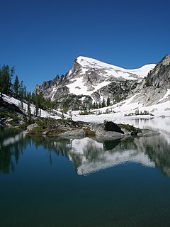
WLittle Annapurna is an 8,440+ ft granite summit located in Chelan County of Washington state. The origin of the name came from the Sherpa Climbing Club of Ellensburg, and is inspired by the obvious resemblance to its Himalayan namesake when comparing the south faces of both. Little Annapurna is part of The Enchantments within the Alpine Lakes Wilderness, and is set on land managed by Okanogan-Wenatchee National Forest. It belongs to the Stuart Range which is subset of the Cascade Range. Little Annapurna is situated southeast of Dragontail Peak, which is its nearest higher neighbor. Remnants of the receding Snow Creek Glacier can be found on its gentle north slope. Precipitation runoff drains into tributaries of the Wenatchee River.
 W
WNavaho Peak is a 7,223-foot (2,202-metre) mountain summit located on the boundary of the Alpine Lakes Wilderness, on the shared border of Kittitas County with Chelan County in Washington state. Navaho Peak is the fourth-highest point in the Teanaway area of the Wenatchee Mountains. It is situated two miles northeast of Earl Peak, on land managed by Wenatchee National Forest. Precipitation runoff from the peak drains south into tributaries of the Teanaway River, or north into tributaries of Ingalls Creek which is part of the Wenatchee River drainage basin. The view from the summit of this peak showcases the impressive Mount Stuart and Stuart Range for those who climb it.
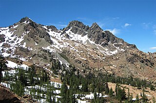
WSherpa Peak is an 8,605-foot (2,623-metre) granite summit located in the Stuart Range, in the Alpine Lakes Wilderness in Chelan County of Washington state. According to the USGS, this peak is "named for a local climbing club" that was "active in the area since the 1950s." In the 1953, a Tibetan-born Sherpa named Tenzing Norgay was the first to summit Mt. Everest with Sir Edmund Hillary. The nearest higher peak is Mount Stuart, 0.41 mi (0.66 km) to the west, and Argonaut Peak lies 1.29 mi (2.08 km) to the east. The Sherpa Glacier lies on the northern slope of the peak. Precipitation runoff from the peak drains north into Mountaineer Creek, a tributary of Icicle Creek, or south into Ingalls Creek, all of which winds up in the Wenatchee River.
 W
WTeanaway Peak is a 6,779-foot (2,066-metre) mountain summit located in the Wenatchee Mountains, on the shared border of Kittitas County with Chelan County in Washington state. It is situated on the boundary of the Alpine Lakes Wilderness, on land managed by Wenatchee National Forest. Its nearest higher neighbor is Bills Peak, 0.72 mi (1.16 km) to the east. Precipitation runoff from the peak drains south into tributaries of the Teanaway River, or north into Turnpike Creek which is part of the Wenatchee River drainage basin. The view from the summit of this peak showcases the impressive Mount Stuart and Stuart Range for those who climb it. This peak also goes by the name "Genes Peak", which is for Gene Prater (1929–1993), the younger brother of Bill Prater, for whom Bills Peak was named. Gene was co-inventor of the modern aluminum snowshoe, and author of the seminal book, "Snowshoeing: From Novice to Master." Gene is also credited with first ascents of Sherpa Peak, Colchuck Balanced Rock, and the east summit of Ingalls Peak.
 W
WThe Enchantments is a region within the Alpine Lakes Wilderness area of Washington state’s Cascade Mountain Range. At an elevation of 4,500 feet, it is home to over 700 alpine lakes and ponds surrounded by the vast peaks of Cashmere Crags, which rate among the best rock-climbing sites in the western United States. The highest peak, Dragontail Peak, stretches 8,840 feet high. The Enchantments is located 15 miles southwest of the popular Bavarian-themed town Leavenworth, Washington in the United States and is regarded as one of the most spectacular regions in the Cascade Range.
 W
WTrico Mountain is a 6,640+ ft mountain summit located 10 mi (16 km) south of Stevens Pass on the common border of King County, Kittitas County and Chelan County in Washington state. "Trico" is a portmanteau of triple county. This peak is part of the Wenatchee Mountains, which are a subset of the Cascade Range, and is situated 20 mi (32 km) west of Leavenworth in the Alpine Lakes Wilderness. Trico is a triple divide peak with precipitation runoff from the mountain draining south into Cle Elum River, northwest into Deception Creek, and northeast into Leland Creek, which is a tributary of Icicle Creek. The scenic Tuck and Robin Lakes are set on the south slopes, between Trico and Granite Mountain, which is 1.6 mi (2.6 km) to the southeast. The Pacific Crest Trail skirts below the western aspect this peak as it crosses Deception Pass.
 W
WWitches Tower is an 8,520+ ft granite summit located 10 mi (16 km) southwest of Leavenworth in Chelan County of Washington state. Witches Tower is part of The Enchantments within the Alpine Lakes Wilderness, and is set on land managed by Okanogan-Wenatchee National Forest. It belongs to the Stuart Range which is subset of the Wenatchee Mountains. Witches Tower is situated 0.8 mi (1.3 km) northwest of Little Annapurna, and 0.4 mi (0.64 km) east-southeast of Dragontail Peak, which is its nearest higher neighbor. Witches Tower is surrounded by remnants of Snow Creek Glacier. Precipitation runoff drains into tributaries of the Wenatchee River.