 W
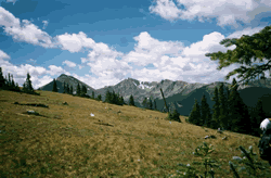
WArapaho National Forest is a National Forest located in north-central Colorado, United States. The facility is managed jointly with the Roosevelt National Forest and the Pawnee National Grassland from the United States Forest Service office in Fort Collins, Colorado. It has a wildlife refuge which manages a protection for all birds and mammals. The combined facility of 1,730,603 acres (7,004 km2) is denoted as ARP by the Forest Service. Separately, Arapaho National Forest consists of 723,744 acres (2,929 km2).
 W
WThe Arapaho National Recreation Area (ANRA) is a United States National Recreation Area that is located near the headwaters of the Colorado River in north central Colorado adjacent to Rocky Mountain National Park. ANRA is under the jurisdiction of the Arapaho-Roosevelt National Forest. ANRA contains five lakes in the upper Colorado River Valley:Lake Granby Shadow Mountain Lake Willow Creek Reservoir Monarch Lake Meadow Creek Reservoir
 W
WArgentine Peak is a high mountain summit in the Front Range of the Rocky Mountains of North America. The 13,743-foot (4,189 m) thirteener is located in Arapaho National Forest, 8.5 miles (13.6 km) southwest by south of Georgetown, Colorado, United States. The summit lies on the Continental Divide between Clear Creek and Summit counties.
 W
WBald Mountain is a high and prominent mountain summit in the Front Range of the Rocky Mountains of North America. The 13,690-foot (4,173 m) thirteener is located in Arapaho National Forest, 5.5 miles (8.9 km) southeast of the Town of Breckenridge in Summit County, Colorado, United States.
 W
WBard Peak is a high and prominent mountain summit in the Front Range of the Rocky Mountains of North America. The 13,647-foot (4,160 m) thirteener is located in Arapaho National Forest, 4.5 miles (7.2 km) west-northwest of the Town of Silver Plume in Clear Creek County, Colorado, United States.
 W
WThe Byers Peak Wilderness is a U.S. Wilderness Area located in Arapaho National Forest in north central Colorado. The 8,913-acre (36.07 km2) wilderness was established in 1993 and named after its highest point, Byers Peak. Byers Peak was named after William N. Byers, the first mayor of Hot Sulphur Springs and the founder of Colorado's first newspaper, the Rocky Mountain News. The wilderness contains two glacial lakes, two peaks over 12,500 feet (3,800 m), and 23 miles (37 km) of trails.
 W
WThe Canyon Lakes Ranger District is part of the Arapaho and Roosevelt National Forests and the Pawnee National Grassland in the United States, specifically on the Roosevelt National Forest. This land is a part of the United States Forest Service. It is located in north-central Colorado in Larimer County and encompasses 650,022 acres (2,631 km2). The Canyon Lakes District Office is located in Fort Collins, Colorado.
 W
WCrystal Peak is a high mountain summit in the Tenmile Range of the Rocky Mountains of North America. The 13,859-foot (4,224 m) thirteener is located in White River National Forest, 5.9 miles (9.5 km) southwest of the Town of Breckenridge in Summit County, Colorado, United States.
 W
WMount Edwards is a high mountain summit in the Rocky Mountains' Front Range of North America. The 13,856-foot (4,223 m) thirteener is located in Arapaho National Forest, 7.6 miles (12.3 km) southwest of the Town of Georgetown, Colorado, United States, on the Continental Divide between Clear Creek and Summit counties.
 W
WElk Mountain is a prominent mountain summit in the Rabbit Ears Range of the Rocky Mountains of North America. The 11,424-foot (3,482 m) peak is located in Arapaho National Forest, 12.9 miles (20.8 km) northwest by west of the Town of Granby in Grand County, Colorado, United States.
 W
WEngelmann Peak is a high mountain summit in the Front Range of the Rocky Mountains of North America. The 13,368-foot (4,075 m) thirteener is located in Arapaho National Forest, 6.3 miles (10.2 km) west by south of the Town of Empire in Clear Creek County, Colorado, United States. The mountain was named in honor of the botanist George Engelmann.
 W
WMount Evans is the highest peak in the namesake Mount Evans Wilderness in the Front Range of the Rocky Mountains of North America. The prominent 14,271-foot fourteener is located 13.4 miles (21.6 km) southwest by south of Idaho Springs in Clear Creek County, Colorado, United States, on the drainage divide between Arapaho National Forest and Pike National Forest.
WFletcher Mountain is a high mountain summit in the Tenmile Range of the Rocky Mountains of North America. The 13,958-foot (4,254 m) thirteener is located in Arapaho National Forest, 8.1 miles (13.0 km) southwest by south of the Town of Breckenridge in Summit County, Colorado, United States.
 W
WGrays Peak is the tenth-highest summit of the Rocky Mountains of North America and the U.S. state of Colorado. The prominent 14,278-foot (4352 m) fourteener is the highest summit of the Front Range and the highest point on the Continental Divide in North America. Grays Peak is located in Arapahoe National Forest, 3.9 miles (6.2 km) southeast by east of Loveland Pass on the Continental Divide between Clear Creek and Summit counties. The peak is the highest point in both counties.
 W
WGrizzly Peak is a high mountain summit in the Front Range of the Rocky Mountains of North America. Also known as Grizzly Peak D, the 13,433-foot (4,094 m) thirteener is located in Arapaho National Forest, 2.1 miles (3.4 km) southeast by east of Loveland Pass, Colorado, United States, on the Continental Divide between Clear Creek and Summit counties. Its proximate parent peak is Torreys Peak.
 W
WThe Indian Peaks Wilderness is a wilderness area in north central Colorado managed jointly by the United States Forest Service and the National Park Service within the Arapaho and Roosevelt National Forests and small parts of the southern section of Rocky Mountain National Park. It borders the James Peak Wilderness to the south, and straddles the Continental Divide. The area receives high visitation due to its proximity to the Denver metropolitan area.
WJames Peak is a high mountain summit in the Front Range of the Rocky Mountains of North America. The 13,300-foot (4,054 m) thirteener is located on the Continental Divide in the James Peak Wilderness of Arapaho National Forest and Roosevelt National Forest, 5.2 miles (8.4 km) east-southeast of the Town of Winter Park, Colorado, United States. The summit is the tripoint of Clear Creek, Gilpin, and Grand counties. The peak is the highest point in Gilpin County and the James Peak Wilderness.
 W
WThe James Peak Wilderness is a U.S. Wilderness Area in north central Colorado in the Arapaho and Roosevelt national forests. The wilderness area borders Indian Peaks Wilderness to the north and the James Peak Protection Area to the west.
 W
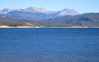
WLake Granby is the third largest body of water in Colorado.
WLone Eagle Peak is a mountain summit in the Indian Peaks of the Front Range of the Rocky Mountains of North America. The 11,946-foot (3,641 m) peak is located in the Indian Peaks Wilderness of Arapaho National Forest, 12.4 miles (19.9 km) northeast by north of the Town of Fraser in Grand County, Colorado, United States. Lone Eagle Peak was named in honor of Charles Lindbergh.
WMeridian Peak is a mountain summit in the Gore Range of the Rocky Mountains of North America. The 12,432-foot (3,789 m) peak is located in the Eagles Nest Wilderness, 9.0 miles (14.5 km) north by west of the Town of Vail, Colorado, United States, on the drainage divide separating White River National Forest and Eagle County from Arapaho National Forest and Summit County.
WThe Mount Evans Wilderness is a U.S. Wilderness Area in Arapaho National Forest and Pike National Forest about 30 miles (48 km) west of Denver, Colorado. The wilderness area is named after Mount Evans.
 W
WMount Parnassus is a high mountain summit in the Front Range of the Rocky Mountains of North America. The 13,580-foot (4,139 m) thirteener is located in Arapaho National Forest, 5.4 miles (8.7 km) west-northwest of the Town of Silver Plume in Clear Creek County, Colorado, United States.
WMount Powell is the highest summit of the Gore Range in the Rocky Mountains of North America. The prominent 13,586-foot (4,141 m) thirteener is located in the Eagles Nest Wilderness, 8.5 miles (13.7 km) north by east of the Town of Vail, Colorado, United States, along the drainage divide separating White River National Forest and Eagle County from Arapaho National Forest and Summit County. Mount Powell was named in honor of John Wesley Powell who climbed to the summit in 1868.
 W
WMount Sniktau is a high mountain summit in the Front Range of the Rocky Mountains of North America. The 13,240-foot (4,036 m) thirteener is located in Arapaho National Forest, 1.6 miles (2.5 km) northeast of Loveland Pass in Clear Creek County, Colorado, United States.
WThe Never Summer Wilderness is a U.S. Wilderness Area located immediately west of Rocky Mountain National Park in the Never Summer Mountains of Arapaho National Forest in northern Colorado. The wilderness has seven mountains over 12,000 feet (3,700 m) in elevation, with the highest being Howard Mountain at 12,810 feet (3,900 m)
WNorth Arapaho Peak is the highest summit of the Indian Peaks in the northern Front Range of the Rocky Mountains of North America. The 13,508-foot (4,117 m) thirteener is located in the Indian Peaks Wilderness, 7.8 miles (12.6 km) west-southwest of the Town of Ward, Colorado, United States, on the Continental Divide separating Roosevelt National Forest and Boulder County from Arapaho National Forest and Grand County.
 W
WThe Rabbit Ears Range is a mountain range of the Rocky Mountains in north central Colorado in the United States. The range stretches east-west along the continental divide forming the border between Grand and Jackson Counties, separating Middle Park (south) from North Park (north). The range connects the Front Range on the east with the Park Range and the Gore Range on the west. It is traversable at Willow Creek Pass. Muddy Pass separates the Rabbit Ears range to the east from the Park Range to the north. Rabbit Ears Pass, and Rabbit Ears Peak, despite their names, are not in the Rabbit Ears Range, but actually reside in the Park Range to the south.
 W
WShadow Mountain Lake is a reservoir in Grand County, Colorado, near the headwaters of the Colorado River. Shadow Mountain Lake is created by Shadow Mountain Dam. The lake forms a continuous body of water with Grand Lake, the largest natural lake in Colorado; they are separated by gates.
WThe Vasquez Peak Wilderness is a U.S. Wilderness Area located southwest of Winter Park, Colorado. The 12,300-acre (5,000 ha) wilderness established in 1993 in the Arapaho and Roosevelt national forests has 15 miles (24 km) of trails.