 W
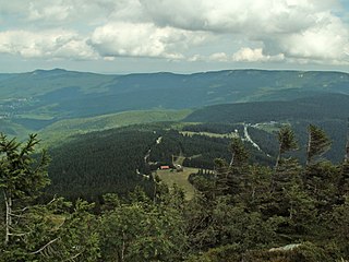
WThe Bavarian Forest is a wooded, low-mountain region in Bavaria, Germany that is about 100 kilometres long. It runs along the Czech border and is continued on the Czech side by the Bohemian Forest. Most of the Bavarian Forest lies within the province of Lower Bavaria, but the northern part lies within Upper Palatinate. In the south it reaches the border with Upper Austria.
 W
WThe Abteiland is a former estate owned by Niedernburg Abbey above Passau. From the early 13th century until the seizure of church property under Napoleon in 1803, the region belonged to the Hochstift or Prince-Bishopric of Passau with the prince bishop as its secular and spiritual head. The region lies in the Bavarian Forest north of the River Danube and east of the River Ilz. It was crossed by a historical trade route, the Goldener Steig. Its main settlement was Waldkirchen, which was granted wide-ranging rights by the prince bishops of Passau.
 W
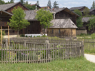
WThe Bavarian Forest Museum Village is an open air museum near Tittling on the southwestern shore of the Dreiburgensee lake in the Bavarian Forest. It covers about 25 hectares and has over 150 buildings from the period from 1580 to 1850 and a local history collection with 60,000 items. It is thus one of the largest open air museums in Europe.
 W
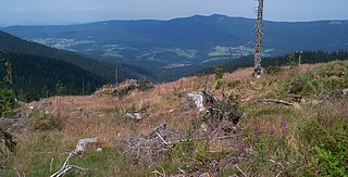
WThe Bavarian Forest National Park is a national park in the Eastern Bavarian Forest immediately on Germany's border with the Czech Republic. It was founded on 7 October 1970 as the first national park in Germany. Since its expansion on 1 August 1997 it has covered an area of 24,250 hectares. Together with the neighbouring Czech Bohemian Forest the Bavarian Forest forms the largest contiguous area of forest in Central Europe.
 W
WThe Bavarian Forest Nature Park covers an area north of the Danube as far as the border ridge with the Czech Republic. Its sponsor organisation is the Naturpark Bayerischer Wald whose head office is in Zwiesel, Bavaria. It was established in 1967 and is thus the oldest nature park in Bavaria.
 W
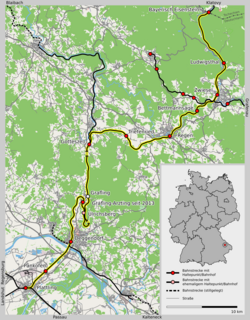
WThe Bavarian Forest Railway links the heart of the Bavarian Forest around Regen and Zwiesel to Plattling and the Danube valley on one side, and the Czech Republic through Bayerisch Eisenstein on the other. In the Danube valley it forms a junction with the Nuremberg–Regensburg–Passau long distance railway and, to the south, regional lines to Landshut and Munich.
 W
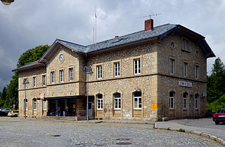
WBayerisch Eisenstein/Železná Ruda-Alžbětín station is a railway station on the border of southeast Germany and the Czech Republic. It forms the junction between the Bavarian Forest railway from Plattling to Bayerisch Eisenstein, which was started in 1874 by the Bavarian Eastern Railway Company and completed by the Royal Bavarian State Railways, and the Pilsen–Markt Eisenstein railway built by the Pilsen–Priesen(–Komotau) railway in what was then Bohemia. The national border between Germany and the Czech Republic runs through the middle of the station building.
 W
WBodenmais is a municipality in the district of Regen in Bavaria in Germany. It lies at one end of the Zeller Valley in the Bavarian Forest.
 W
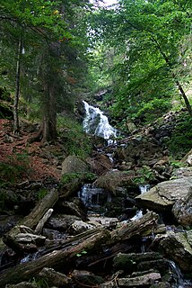
WThe Buchberger Leite is a gorge near Hohenau in the Lower Bavarian county of Freyung-Grafenau in Bavaria.
 W
WThe Danube Hills, also variously called the Vorderer Forest, Anterior Bavarian Forest or Vorderer Wald, is part of the Bavarian Forest, a low mountain range in Germany.
 W
WDrachselsried is a municipality in the district of Regen, in Bavaria, Germany. Drachselsried is in the Zeller Valley, and is part of the Glass Road (Glasstrasse) The area is part of the Bavarian Forest National Park. The village is a small, highly organised, friendly place to live. Bayern Eins, the German radio station, gave some history details of the village, which was first noted in 1184. I am English living in Drachselsried and have created a local English website. The village continues to grow with the addition in 2017 of a retirement home with private apartments, close to the village centre. A number of new homes have been built on land available for purchase from the local council.
 W
WThe Enzian is a mountain, 1,285 m above sea level (NHN), in the Bavarian Forest in Germany. It rises from the ridge northwest of the Arber and its summit lies on the boundary between the counties of Cham and Regen, with the municipality of Lohberg in the north and Drachselsried in the west-southwest.
 W
WFrauenau is a municipality in the district of Regen, in Bavaria, Germany. It is known for its artificial lake, which is used as a water supply of the area around Deggendorf and Passau.
 W
WThe Frauenau Dam in the Bavarian Forest, was built in 1983 to ensure the drinking water supply to large parts of Lower Bavaria.
 W
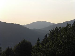
WThe Großer Arber ; Czech: Velký Javor, "Great Maple") or Great Arber, is the highest peak of the Bavarian/Bohemian Forest mountain range and in Lower Bavaria, with an elevation of 1,455.5 metres (4,775 ft). As a result, it is known in the Lower Bavarian county of Regen and the Upper Palatine county of Cham as the "King of the Bavarian Forest". Its summit region consists of paragneiss.
 W
WThe Höllbachgspreng is a wooded rock massif below the Großer Falkenstein mountain in the vicinity of Lindberg in the Bavarian Forest, Germany.
 W
WThe Kunisch Mountains is a range that includes part of the Bavarian Forest and the central Bohemian Forest, with its main chain between the Osser and the Zwercheck close to Upper Palatinate. From a geological perspective the Kunisch Mountains occupy a special position, because they are made of mica schist instead of the gneisses and granites that are common elsewhere in the Bavarian Forest. It has good farming soils and heavy precipitation which often falls as snow and ice in winter.
 W
WThe Lallinger Winkel is a high valley, 162 km² in area, named after the village of Lalling, in the county of Deggendorf in the Bavarian Forest.
 W
WThe Lamer Winkel is a region in the northern Bavarian Forest between the mountains of Hoher Bogen, Osser, Arber and Kaitersberg; politically it belongs to the county of Cham in the Bavarian province of Upper Palatinate.
 W
WThe Lower Bavarian Open-Air Museums in Massing and Mauth has the objective of portraying the old ways of life and domestic and agricultural activities of the farming population of Lower Bavaria. It is owned by a communal special purpose association formed by the province of Lower Bavaria, the counties of Rottal-Inn and Freyung-Grafenau, and the municipalities of Massing and Mauth. The museums are under academic leadership.
 W
WThe Pfahl is a 150-kilometre-long quartz vein that runs through the northeastern Bavarian Forest in Germany. From a geomorphological point of view, it represents a residual ridge that has been formed by weathering and erosion over millions of years.
 W
WRegen is a town in Bavaria, Germany, and the district town of the district of Regen.
 W
WThe Regen Depression is a wide river valley in the Bavarian Forest along the River Regen.
 W
WThe Riedlhütte narrow-gauge railway is a not for profit light railway in Sankt Oswald-Riedlhütte in the Bayerischer Wald.
 W
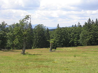
WSchachten (singul.) are ancient areas of pasture in the Bavarian Forest in Germany, some of which are still used today.
 W
WThe Spiegelau Forest Railway was a 600 mm narrow gauge forest railway built for the transportation of logs from the woods around Spiegelau in the Bavarian Forest in southern Germany.
 W
WThe Upper Bavarian Forest Nature Park covers an area of 1,796 km² and is thus one of the largest nature parks in the German state of Bavaria.
 W
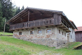
WThe Waldlerhaus is a local form of agricultural building, typical of the Bavarian Forest and Upper Palatine Forest in Germany. The term Waldlerhaus goes back to the 19th century and describes the house of a person who lives in and from the forest.
 W
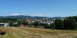
WZwiesel, Czech: Svízel, is a town located in the lower-Bavarian district of Regen, and since 1972 is a state-approved health resort with particularly good air. The name of the town was derived from the Bavarian word stem "zwisl" which refers to the form of a fork. The fork of the rivers Großer Regen and Kleiner Regen and the land that lies between these two rivers were called Zwiesel.
 W
WZwiesel station is the most important railway hub in the Bavarian Forest. It is the only station of the Lower Bavarian town of Zwiesel. Apart from this station, the town also contains Lichtenthal station in the Zwiesel district of Lichtenthal. It is classified by Deutsche Bahn as a category 3 station and has four platform tracks. Zwiesel is located on the railway between Plattling and Bayerisch Eisenstein/Železná Ruda-Alžbětín, also called the Bavarian Forest Railway. In Zwiesel station the lines to Grafenau and to Bodenmais branch off the Bavarian Forest Railway. The lines are maintained by DB Regio and the services are operated by Regentalbahn.