 W
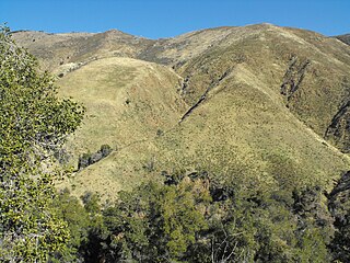
WCleveland National Forest encompasses 460,000 acres, mostly of chaparral, with a few riparian areas. A warm dry mediterranean climate prevails over the forest. It is the southernmost U.S. National Forest of California. It is administered by the U.S. Forest Service, a government agency within the United States Department of Agriculture. It is divided into the Descanso, Palomar and Trabuco Ranger Districts and is located in the counties of San Diego, Riverside, and Orange.
 W
WCupressus stephensonii is a species of conifer known as the Cuyamaca cypress, and is endemic to southern California. It has been classified as Hesperocyparis stephensonii. It was previously listed as Cupressus arizonica subsp. stephensonii and Cupressus arizonica var. glabra.
 W
WPseudotsuga macrocarpa, commonly called the bigcone spruce or bigcone Douglas-fir, is an evergreen conifer native to the mountains of southern California, It is notable for having the largest cones in the genus Pseudotsuga, hence the name.
 W
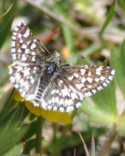
WPyrgus ruralis lagunae, the Laguna Mountains skipper, is a butterfly of the family Hesperiidae. It is a subspecies of Pyrgus ruralis.
 W
WAgua Tibia Wilderness (ATW) is a 17,961-acre (72.69 km2) protected area in Riverside and San Diego counties, in the U.S. state of California. It is mostly within the Palomar Ranger District of the Cleveland National Forest. The area was originally protected as the Agua Tibia Primitive Area until January 1975 when it was added to the National Wilderness Preservation System with the passage of Public Law 93-632 by the United States Congress. Between its inception and 1984, the ATW was San Diego County's only officially designated wilderness area. The Spanish name, Agua Tibia, translates as warm water.
 W
WBlack Star Canyon is a remote mountain canyon in the Santa Ana Mountains, located in eastern Orange County, California. It is a watershed of the Santa Ana River. Black Star Canyon is a popular destination for mountain bikers as well as hikers due to its wild scenery.
 W
WCalifornia's 71st State Assembly district is one of 80 California State Assembly districts. It is currently represented by Republican Randy Voepel of Santee.
 W
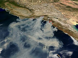
WThe Cedar Fire was a massive, highly-destructive wildfire, which burned 273,246 acres (1,106 km2) of land in San Diego County, California, during October and November 2003. The fire's rapid growth was driven by the Santa Ana winds, causing the fire to spread at a rate of 3,600 acres (15 km2) per hour. By the time the fire was fully contained on November 4, it had destroyed 2,820 buildings and killed 15 people, including one firefighter. Hotspots continued to burn within the Cedar Fire's perimeter until December 5, 2003, when the fire was fully brought under control.
WCupressus stephensonii is a species of conifer known as the Cuyamaca cypress, and is endemic to southern California. It has been classified as Hesperocyparis stephensonii. It was previously listed as Cupressus arizonica subsp. stephensonii and Cupressus arizonica var. glabra.
 W
WThe Cuyamaca Mountains, locally the Cuyamacas, are a mountain range of the Peninsular Ranges System, in San Diego County, southern California. The mountain range runs roughly northwest to southeast. The Laguna Mountains are directly adjacent to the east, with Palomar Mountain and Hot Springs Mountain more distant to the north.
 W
WDevil Canyon Creek, a stream or arroyo, tributary to San Mateo Creek, in the Santa Margarita Mountains, all but its first and last part within the Cleveland National Forest in San Diego County, California. Its source is at an altitude of 2440 feet on a flat private land in the Santa Margarita Mountains. and it flows southwestward then turns down into the canyon and the San Mateo Wilderness and northward 2 miles before turning westward toward its confluence in San Mateo Canyon with San Mateo Creek at an elevation of 453 feet. The last half mile of the creek before this confluence is outside the National Forest boundary, and within the Camp Pendleton Marine Corps Base. Devil Canyon has one named tributary, Cold Spring Canyon Creek, draining the Santa Margarita Mountains north of the Devil Canyon watershed that enters it from the right about a mile and half above the confluence of Devil Canyon Creek with San Mateo Creek.
 W
WEl Cajon Mountain, commonly known as El Capitan or El cap, is a mountain in the Cuyamaca Mountains, and prominent natural landmark in the East County of San Diego.
 W
WThe Elsinore Mountains are a ridge of mountains within the larger range of the Santa Ana Mountains, in the Cleveland National Forest, Riverside County, California, United States. the tallest peaks within the range is the unofficially named San Mateo Peak at 3,591 ft (1,095 m). Second is officially named Elsinore Peak at 3,536 ft (1,078 m). The Elsinore Mountanins run in a ridge from just east of El Cariso, southeast to Elsinore Peak. Beyond that peak the ridge begins to descend and curves to the east. From Elsinore Peak, a ridge runs to the west and then northwest to San Mateo Peak, enclosing the Morrell Potrero on the south and west.
WElsinore Peak is a named 3,575-foot (1,090 m) summit, at the southern end of the mountain ridge running southeast from the vicinity east of El Cariso in the Elsinore Mountains, in Riverside County, California in the United States.
 W
WGreystone Villa, Cabin 18, is a historic building located in the Santa Ana Mountains within Cleveland National Forest, in Orange County, Southern California. It is listed in the National Register of Historic Places.
 W
WThe Laguna Mountains are a mountain range of the Peninsular Ranges System in eastern San Diego County, southern California. The mountains run in a northwest/southeast alignment for approximately 35 miles (56 km).
WPyrgus ruralis lagunae, the Laguna Mountains skipper, is a butterfly of the family Hesperiidae. It is a subspecies of Pyrgus ruralis.
WLos Alamos Canyon Creek, a stream or arroyo, tributary to San Mateo Creek, in the Cleveland National Forest in Riverside County, California. Its source is at an altitude of 2300 feet, in a canyon on the south face of the ridge of Elsinore Mountains that descends to the southeast from Elsinore Peak. The creek descends southward for a short distance then turns southwest for 4 miles where it turns west for 3 miles down Los Alamos Canyon to its confluence with San Mateo Creek at an elevation of 1312 feet.
 W
WMargarita Lookout, also known as Santa Margarita Lookout, is a lookout point in the Santa Margarita Mountains, part of the larger Santa Ana Mountains in San Diego County, California. The original fire lookout tower, built in 1935 by the CCC, was later replaced by a new lookout tower and cabin in 1965. In 1986, the tower and cabin were both burned in a wildfire. In 1988, the burnt tower was destroyed in a collision with a Marine Corps CH-46E helicopter. The lookout tower was badly damaged as a result and was promptly removed. Only a concrete foundation remains today, however the site is still accessible via trail. The lookout is approximately one mile north of Margarita Peak, and is located in the Cleveland National Forest.
 W
WModjeska Peak is the northern mountain of Orange County's Saddleback formation. It is the second highest peak of the Santa Ana Mountains, and is in the Cleveland National Forest.
 W
WMorrell Canyon Creek is a stream or Arroyo, tributary to San Juan Creek, located in the Cleveland National Forest in Riverside County, California, at an elevation of 3,080 ft (939 m), in the Elsinore Mountains northeast of Elsinore Peak. It arises on the eastern slope of San Mateo Peak. An eastern fork draining the Morrell Potrero joins it a little over a mile north of its source and then flows northwestward about a third of a mile where it turns southeast descending the narrow Morrell Canyon east of Lion Spring. After descending 2.5 miles it turns north for half a mile then returns to a southwestern direction for another mile, the canyon widening here until it turns northwestward and down a steep canyon again for half a mile where it takes in from the right Decker Canyon Creek and Long Canyon Creek. It then turns southwestward again into a wider canyon and descends to its confluence with Bear Canyon Creek and becomes the head of San Juan Creek.
 W
WMount Laguna Observatory (MLO) is an astronomical observatory owned and operated by San Diego State University (SDSU). The telescope was operated in partnership with the University of Illinois at Urbana-Champaign (UIUC) until 2000. MLO is located approximately 75 kilometers (47 mi) east of downtown San Diego, California (USA) on the eastern edge of the Cleveland National Forest in the Laguna Mountains on the SDSU Astronomy Campus near the hamlet of Mount Laguna. MLO was dedicated on June 19, 1968, seven years after SDSU's Department of Astronomy became an independent academic department of SDSU's College of Sciences. The dedication took place during the 1968 summer meeting of the Astronomical Society of the Pacific. Currently SDSU is working with University of Kansas (KU), and UNC Chapel Hill on various projects.
 W
WPalomar Mountain is a mountain ridge in the Peninsular Ranges in northern San Diego County. It is famous as the location of the Palomar Observatory and Hale Telescope, and known for the Palomar Mountain State Park.
 W
WThe San Luis Rey River is a river in northern San Diego County, California.
 W
WSan Mateo Creek is a stream in Southern California in the United States, whose watershed mostly straddles the border of Orange and San Diego Counties. It is about 22 miles (35 km) long, flowing in a generally southwesterly direction. Draining a broad valley bounded by the Santa Ana Mountains and Santa Margarita Mountains, San Mateo Creek is notable for being one of the last unchannelized streams in Southern California.
 W
WSan Mateo Peak is the unofficially named 3,591-foot (1,095 m) peak, at the western end of the ridge running west then northwest from Elsinore Peak to Morrell Canyon, south and west of the Morrell Potrero in the Elsinore Mountains of the Santa Ana Mountain Range. The peak name was given by Sierra Club Lower Peaks Committee Guide, originally named by Ken Croker who for 20 years maintained trails in the Santa Ana Mountains with volunteers from the Sierra Club. It remains officially nameless despite being the highest summit in the Elsinore Mountains, higher than Elsinore Peak, at 3536 ft., the highest named peak in those mountains.
 W
WThe Santa Ana Mountains are a short peninsular mountain range along the coast of Southern California in the United States. They extend for approximately 61 miles (98 km) southeast of the Los Angeles Basin largely along the border between Orange and Riverside counties.
 W
WThe Santiago Fire was a wildfire located near Santiago Canyon in Orange County, California, U.S., and one of thirty California wildfires of October 2007. The fire was intentionally started.
 W
WSantiago Peak is the southern mountain of Orange County's Saddleback formation. It is the highest and most prominent peak of both the Santa Ana Mountains and Orange County, and also marks a border point with Riverside County. The top of it is covered with many microwave and telecommunication antennas. It is named for Santiago Creek, which begins on its southwestern flank. During winter, snow does fall on the peak.
WTenaja Canyon Creek, a stream or arroyo, tributary to San Mateo Creek, in the Cleveland National Forest in Riverside County, California. Its source is at an altitude of 1875 feet. The creek has its source at the confluence of arroyos from El Potrero del Tenaja, Redonda Mesa and Squaw Mountain highlands. and it flows northwestward 3 1/2 miles down Tenaja Canyon to its mouth and its confluence near Fishermans Camp, at an elevation of 1112 feet with San Mateo Creek.