 W
WThe Highland Boundary Fault is a major fault zone that traverses Scotland from Arran and Helensburgh on the west coast to Stonehaven in the east. It separates two different geological terranes which give rise to two distinct physiographic terrains: the Highlands and the Lowlands, and in most places it is recognisable as a change in topography. Where rivers cross the fault, they often pass through gorges, and the associated waterfalls can be a barrier to salmon migration.
 W
WAberfoyle is a village in the historic county and registration county of Perthshire and the council area of Stirling, Scotland. The settlement lies 27 miles northwest of Glasgow.
 W
WAlyth is a town in Perth and Kinross, Scotland, 5 miles northeast of Blairgowrie and about 17 miles northwest of Dundee. In 2016 the town had an estimated population of 2,400.
 W
WThe Isle of Arran or simply Arran is an island off the west coast of Scotland. It is the largest island in the Firth of Clyde and the seventh largest Scottish island, at 432 square kilometres (167 sq mi). Historically part of Buteshire, it is in the unitary council area of North Ayrshire. In the 2011 census it had a resident population of 4,629. Though culturally and physically similar to the Hebrides, it is separated from them by the Kintyre peninsula. Often referred to as "Scotland in Miniature", the island is divided into highland and lowland areas by the Highland Boundary Fault and has been described as a "geologist's paradise".
 W
WBlairgowrie and Rattray is a twin burgh in Perth and Kinross, Scotland. Locals refer to the town as "Blair". Blairgowrie is the larger of the two former burghs which were united by an Act of Parliament in 1928 and lies on the southwest side of the River Ericht while Rattray is on the northeast side. Rattray claims to be the older and certainly Old Rattray, the area round Rattray Kirk, dates back to the 12th century. New Rattray, the area along the Boat Brae and Balmoral Road dates from 1777 when the River was spanned by the Brig o' Blair. The town lies on the north side of Strathmore at the foot of the Grampian Mountains. The west boundary is formed by the Knockie, a round grassy hill, and Craighall Gorge on the Ericht. Blairgowrie and Rattray developed over the centuries at the crossroads of several historic routes with links from the town to Perth, Coupar Angus, Alyth and Braemar. The roads to Coupar Angus and Braemar form part of General Wade's military road from Perth to Fort George. The town's centrepiece is the Wellmeadow, a grassy triangle in the middle of town which hosts regular markets and outdoor entertainment.
 W
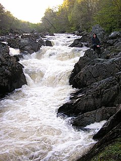
WThe Bracklinn Falls are a series of waterfalls north-east of Callander, Scotland on the course of the Keltie Water, where the river crosses the Highland Boundary Fault.
WThe Isle of Bute, known as Bute, is an island in the Firth of Clyde in Scotland, United Kingdom. It is divided into highland and lowland areas by the Highland Boundary Fault.
 W
WCallander is a small town in the council area of Stirling, Scotland, situated on the River Teith. The town is located in the historic county of Perthshire and is a popular tourist stop to and from the Highlands.
WCallander is a small town in the council area of Stirling, Scotland, situated on the River Teith. The town is located in the historic county of Perthshire and is a popular tourist stop to and from the Highlands.
 W
WThe Central Lowlands, sometimes called the Midland Valley or Central Valley, is a geologically defined area of relatively low-lying land in southern Scotland. It consists of a rift valley between the Highland Boundary Fault to the north and the Southern Uplands Fault to the south. The Central Lowlands are one of the three main geographical sub-divisions of Scotland, the other two being the Highlands and Islands which lie to the north, northwest and the Southern Uplands, which lie south of the associated second fault line.
 W
WThe Chapel of St. Mary and St. Nathalan is a ruined chapel overlooking the North Sea immediately north of Stonehaven, in the Mearns of Scotland, along the northern shoreline of Stonehaven Bay. The founding of this Christian place of worship is associated with St. Nathalan. who lived circa 650 AD. The structure is alternatively known as Cowie Chapel. The chapel is at the point where the Highland Boundary Fault meets the sea and so is on the dividing line between the highlands and lowlands of Scotland.
 W
WComrie is a village and parish in the southern Highlands of Scotland, towards the western end of the Strathearn district of Perth and Kinross, 7 mi (11 km) west of Crieff. Comrie is a historic conservation village, situated in a national scenic area around the river Earn. Its position on the Highland Boundary Fault accounts for it experiencing more earth tremors than anywhere else in Britain. The parish is twinned with Carleton Place, Ontario, Canada.
 W
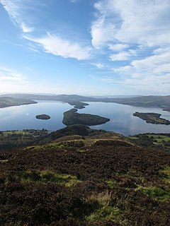
WCreinch is an island on the Highland boundary fault in Loch Lomond.
 W
WCrieff is a Scottish market town in Perth and Kinross. It lies on the A85 road between Perth and Crianlarich, and the A822 between Greenloaning and Aberfeldy. The A822 joins the A823, which leads to Dunfermline. Crieff has become a hub for tourism, famous for its whisky and history of cattle droving. Attractions include the Caithness Glass Visitor Centre and Glenturret Distillery. The nearby Innerpeffray Library, is Scotland's oldest lending library. St Mary's Chapel, adjacent to the library, dates from 1508. Both are open to the public: the library is run by a charitable trust, while the chapel is in the care of Historic Scotland.
 W
WEdzell is a village in Angus, Scotland. It is 5 miles (8 km) north of Brechin, by the River North Esk. Edzell is a Georgian-era planned town, with a broad main street and a grid system of side streets. Originally called Slateford, Edzell was renamed in 1818 after an earlier hamlet 1.5 miles (2.5 km) to the west, which by then had been abandoned. Edzell's population in 2004 was 780.
 W
WLoch Errochty is a man made freshwater loch situated within the Perth and Kinross council area at the edge of the Scottish Highlands near the Highland Boundary Fault where the topography changes to lowland.
 W
WGlenalmond or Glen Almond is a glen which stretches for several miles to the west of the city of Perth in Perth and Kinross, Scotland and down which the River Almond flows. The upper half of the glen runs through mountainous country and is virtually uninhabited whilst the lower, easterly section of the glen is more open. The change in character takes place as the river crosses the Highland Boundary Fault, leaving the Grampian Highlands for the Central Lowlands.
WThe Grampian Mountains are one of the three major mountain ranges in Scotland, occupying a considerable portion of the Scottish Highlands in northern Scotland. The other major mountain ranges in Scotland are the Northwest Highlands and the Southern Uplands. The Grampian range extends southwest to northeast between the Highland Boundary Fault and the Great Glen, occupying almost half of the land area of Scotland and including the Cairngorms and the Lochaber hills. The range includes many of the highest mountains in the British Isles, including Ben Nevis and Ben Macdui.
 W
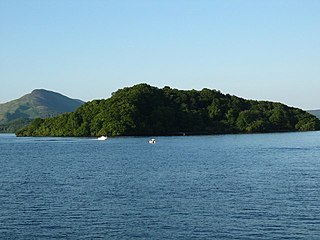
WInchcailloch is an islet on Loch Lomond in Scotland. It is 85 metres (279 ft) at its highest point. It is also known to some as Inchebroida.
 W
WInnellan is a village on the east shore of the Cowal peninsula, on the Firth of Clyde, 4 miles south of the town of Dunoon, Argyll and Bute in Scotland.
 W
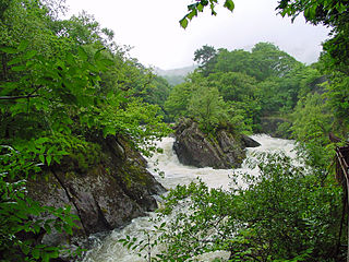
WThe Falls of Leny are a series of waterfalls in the Trossachs of Scotland on the course of the Garbh Uisge, otherwise known as the River Leny, where the river crosses the Highland Boundary Fault. The falls are located near the Pass of Leny, just north-west of Callander.
 W
WLoch Lomond is a freshwater Scottish loch which crosses the Highland Boundary Fault, often considered the boundary between the lowlands of Central Scotland and the Highlands. Traditionally forming part of the boundary between the counties of Stirlingshire and Dunbartonshire, Loch Lomond is split between the council areas of Stirling, Argyll and Bute and West Dunbartonshire. Its southern shores are about 23 kilometres (14 mi) northwest of the centre of Glasgow, Scotland's largest city. The Loch forms part of the Loch Lomond and The Trossachs National Park which was established in 2002.
 W
WThe North Esk is a river in Angus and Aberdeenshire, Scotland. It is formed by the meeting of the Water of Mark and the Water of Lee, and enters the North Sea four miles north of Montrose. It forms the boundary between Angus and Aberdeenshire at certain stages in its course. It was also noted in the 19th century as a good point for fishing.
 W
WThe Highlands is a historic region of Scotland. Culturally, the Highlands and the Lowlands diverged from the later Middle Ages into the modern period, when Lowland Scots replaced Scottish Gaelic throughout most of the Lowlands. The term is also used for the area north and west of the Highland Boundary Fault, although the exact boundaries are not clearly defined, particularly to the east. The Great Glen divides the Grampian Mountains to the southeast from the Northwest Highlands. The Scottish Gaelic name of A' Ghàidhealtachd literally means "the place of the Gaels" and traditionally, from a Gaelic-speaking point of view, includes both the Western Isles and the Highlands.
WThe Lowlands is a cultural and historical region of Scotland. Culturally, the Lowlands and the Highlands diverged from the later Middle Ages into the modern period, when Lowland Scots replaced Scottish Gaelic throughout most of the Lowlands.
 W
WStirling is a city in central Scotland, 26 miles (42 km) north-east of Glasgow and 37 miles (60 km) north-west of the Scottish capital, Edinburgh. The market town, surrounded by rich farmland, grew up connecting the royal citadel, the medieval old town with its merchants and tradesmen, the Old Bridge and the port. Located on the River Forth, Stirling is the administrative centre for the Stirling council area, and is traditionally the county town of Stirlingshire. Proverbially it is the strategically important "Gateway to the Highlands".
 W
WStonehaven is a town in Aberdeenshire, Scotland. It lies on Scotland's northeast coast and had a population of 11,602 at the 2011 Census. After the demise of the town of Kincardine, which was gradually abandoned after the destruction of its royal castle in the Wars of Independence, the Scottish Parliament made Stonehaven the successor county town of Kincardineshire. Stonehaven had grown around an Iron Age fishing village, now the "Auld Toon", and expanded inland from the seaside. As late as the 16th century, old maps indicate the town was called Stonehyve, Stonehive, Timothy Pont also adding the alternative Duniness. It is known informally to locals as Stoney.
 W
WTorrinch or Inchtore is a wooded island in Loch Lomond in Scotland. The name Torremach is also recorded for it.
 W
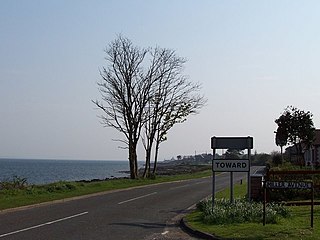
WToward; is a village near Dunoon at the southern tip of the Cowal peninsula with views down the Firth of Clyde, located in Argyll and Bute, Scotland.
 W
WToward Point Lighthouse is on the southern extremity of the Cowal Peninsula, near the village of Toward and six miles south of Dunoon, Argyll and Bute, Scotland. There has been a lighthouse here since 1812.