 W
WJasper National Park is a national park in Alberta, Canada. It is the largest national park within Alberta's Rocky Mountains spanning 11,000 km2 (4,200 sq mi). Its location is north of Banff National Park and west of Edmonton. The park contains the glaciers of the Columbia Icefield, springs, lakes, waterfalls and mountains.
 W
WThe Angel Glacier is an extensive glacier which flows down the north face of Mount Edith Cavell in Jasper National Park, Canada. It is named as such because it has the appearance of an angel with out-swept wings. It was significantly larger when it was named in the 19th-century and is melting rapidly. It is not expected to maintain its shape, and will most likely disappear.
 W
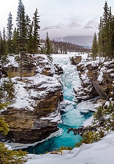
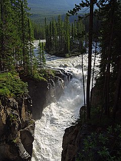
WAthabasca Falls is a waterfall in Jasper National Park on the upper Athabasca River, approximately 30 kilometres (19 mi) south of the townsite of Jasper, Alberta, Canada, and just west of the Icefields Parkway.
WThe Athabasca Glacier is one of the six principal 'toes' of the Columbia Icefield, located in the Canadian Rockies. The glacier currently loses depth at a rate of about 5 metres (16 ft) per year and has receded more than 1.5 km (0.93 mi) and lost over half of its volume in the past 125 years. Easily accessible, it is the most visited glacier in North America. The leading edge of the glacier is within easy walking distance; however, travel onto the glacier is not recommended unless properly equipped. Hidden crevasses have led to the deaths of unprepared tourists.
 W
WAthabasca Pass is a high mountain pass in the Canadian Rockies on the border between Alberta and British Columbia. In fur trade days it connected Jasper House on the Athabasca River with Boat Encampment on the Columbia River.
 W
WThe Athabasca River is a river in Alberta, Canada, which originates at the Columbia Icefield in Jasper National Park and flows more than 1,231 km (765 mi) before emptying into Lake Athabasca. Much of the land along its banks is protected in national and provincial parks, and the river is designated a Canadian Heritage River for its historical and cultural importance. The scenic Athabasca Falls is located about 30 km (19 mi) upstream from Jasper.
 W
WThe Great Divide Trail (GDT) is a wilderness hiking trail in the Canadian Rockies. The trail closely follows the Great Divide between Alberta and British Columbia, crossing the divide more than 30 times. Its southern terminus is in Waterton Lakes National Park at the Canada–US border and its northern terminus is at Kakwa Lake in Kakwa Provincial Park, north of Jasper National Park. The trail is 1,130 km (700 mi) long and ranges in elevation from 1,055 m (3,461 ft) at Old Fort Point trailhead near Jasper to 2,590 m (8,500 ft) at an unnamed pass above Michele Lakes just south of the White Goat Wilderness Area.
 W
WImprovement District No. 12 , or Improvement District No. 12, is an improvement district in Alberta, Canada. Located within Jasper National Park in Alberta's Rockies, the improvement district is the municipality that provides local government for the portion of the park outside the Municipality of Jasper.
 W
WJasper Airport,, is located 7.2 nautical miles north of Jasper, Alberta, Canada. It is mainly used for diversions and military use.
 W
WJasper House National Historic Site, in Jasper National Park, Alberta, is the site of a trading post on the Athabasca River that functioned in two different locations from 1813 to 1884 as a major staging and supply post for travel through the Canadian Rockies.
 W
WJasper Lake is a lake located in the Rockies of Jasper National Park in Alberta, Canada. It is actually a part of the Athabasca River, where the river broadens out. Its westernmost shore lies about 15 miles (24 km) northeast from the town of Jasper along the Yellowhead Highway and stretches farther east for about 6 miles (9.7 km).
 W
WThe Jasper Park Information Centre National Historic Site, located in Jasper National Park, Alberta, Canada, is the primary visitor contact centre for visitors to the park. Sited in the Jasper townsite, it was built as the park administration building in 1913-1914, and became the visitor contact centre in 1972. It is located in Athabasca Park, which is not included in the National Historic Site designation.
 W
WJasper is a specialized municipality in western Alberta, Canada. It is the commercial centre of Jasper National Park, located in the Canadian Rockies within the Athabasca River valley. Jasper is approximately 362 kilometres (225 mi) west of Edmonton and 290 kilometres (180 mi) north of Banff, Alberta, at the intersection of Highway 16 and Highway 93.
 W
WLac Beauvert, or Beauvert Lake is a small lake (0.4 km²) in Jasper National Park, Alberta, Canada.
 W
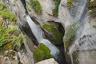
WMaligne Canyon is a slot canyon located in the Jasper National Park near Jasper, Alberta, Canada. Eroded out of the Palliser Formation, the canyon measures over 50 metres (160 ft) deep. Popular for sightseeing and exploration, the area contains waterfalls, underground stream outlets, birds and plant life.
 W
WMaligne Lake is a lake in Jasper National Park, Alberta, Canada. The lake is famed for the colour of its azure water, the surrounding peaks, the three glaciers visible from the lake, and Spirit Island, a frequently and very famously photographed islet. The lake is located 44 km (27 mi) south of Jasper town, and is accessible by motor vehicle, including shuttle buses from Jasper. Boat tours run to Spirit Island in the spring to autumn season. The 44 km Skyline Trail, Jasper's most popular, highest and above treeline, multi-day hike, begins at Maligne Lake and finishes near the town of Jasper. Other popular day hikes include the Opal Hills and Bald Hills loops. Winter activities include cross-country skiing and snowboarding.
Marmot Basin is an alpine ski area located in Alberta's Jasper National Park.
 W
WMedicine Lake is located within Jasper National Park, Alberta, Canada. It is located approximately 20 km (12 mi) southeast of the townsite of Jasper, Alberta. Medicine Lake is approximately 7 km (4.3 mi) long and is a relatively shallow lake. The lake is part of the Maligne Valley watershed which is mainly glacial fed.
 W
WMiette Hot Springs are commercially developed hot springs located in Jasper National Park in Alberta, Canada, near Jasper. The pool is outdoors and offers visitors a view of the surrounding Fiddle River Valley. The hot springs are located at the end of a 15 km seasonal road and are located 61 km northeast of Jasper. Water temperature is kept at approximately 40°C (104°F)
 W
WThe Miette River is a short river in Jasper National Park, Alberta, Canada. It flows south-southwest through the Rocky Mountains before draining into the Athabasca River.
 W
WPatricia Lake is a lake in Jasper National Park, Alberta, Canada, near the town of Jasper. It was named for Princess Patricia of Connaught, a granddaughter of Queen Victoria.
WPocahontas is a campground, an unincorporated area in Improvement District No. 12 within Alberta's Rockies. It is located on Highway 16, approximately 38 km (24 mi) northeast of Jasper, at the junction that provides access to Jasper National Park's Miette Hot Springs.
 W
WPyramid Lake is a kidney-shaped lake in Jasper National Park, Alberta, Canada. It lies at the foot of Pyramid Mountain, a natural landmark that overlooks the town of Jasper. It has a total area of 1.2 km2 (0.46 sq mi) and discharges in Athabasca River through the 2 km (1.2 mi) long Pyramid Creek.
 W
WThe Snaring River is a medium-sized river in the Canadian Rockies. It runs through parts of Jasper National Park in Alberta, Canada. The Snaring River is a significant tributary of the Athabasca River. The Snaring is named after a former local tribe of first nations people who lived in dugouts and trapped animals with snares.
 W
WSpirit Island is a tiny tied island in Maligne Lake in Jasper National Park. This landmark is the destination of boat trips across Maligne Lake, a view many people associate with the Canadian Rockies. Spirit Island enjoys worldwide reputation, and is one of the most famous and photographed views of the Canadian Rockies. Maligne Lake boat cruises offer close views of the island.
 W
WSunwapta Falls is a pair of waterfalls of the Sunwapta River located in Jasper National Park, Alberta, Canada.
 W
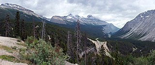
WSunwapta Pass is a mountain pass in the Canadian Rockies in the province of Alberta. Sunwapta Pass is the low point of the saddle created between Mount Athabasca and Nigel Peak. The pass marks the boundary between Banff and Jasper National Parks. The Icefields Parkway travels through Sunwapta Pass 108 km (67 mi) southeast of the town of Jasper and 122 km (76 mi) northwest of the Parkway's junction with the Trans-Canada Highway near Lake Louise. The pass is the second highest point on the Icefields Parkway. Bow Summit in Banff National Park is the highest point on the parkway.
WThe Sunwapta River is a major tributary of the Athabasca River in Jasper National Park in Alberta, Canada.
 W
WThe Tonquin Valley is located in Jasper National Park, Alberta, Canada, next to the border of the provinces of Alberta and British Columbia, an area which is also the continental divide, running along the peaks of the South Jasper Range which rise above Amethyst Lake. Tonquin Creek drains Moat Lake and flows west into Mount Robson Provincial Park in British Columbia, and empties into the Fraser River. The Astoria River drains south and east into the Athabasca River.
 W
WThe Yellowhead Pass is a mountain pass across the Continental Divide of the Americas in the Canadian Rockies. It is located on the provincial boundary between the Canadian provinces of Alberta and British Columbia, and lies within Jasper National Park and Mount Robson Provincial Park.