 W
WA large igneous province (LIP) is an extremely large accumulation of igneous rocks, including intrusive and extrusive, arising when magma travels through the crust towards the surface. The formation of LIPs is variously attributed to mantle plumes or to processes associated with divergent plate tectonics. The formation of some of the LIPs the past 500 million years coincide in time with mass extinctions and rapid climatic changes, which has led to numerous hypotheses about the causal relationships. LIPs are fundamentally different from any other currently active volcanoes or volcanic systems.
 W
WThe Agulhas Plateau is an oceanic plateau located in the south-western Indian Ocean about 500 km (310 mi) south of South Africa. It is a remainder of a large igneous province (LIP), the Southeast African LIP, that formed 140 to 95 million years ago (Ma) at or near the triple junction where Gondwana broke-up into Antarctica, South America, and Africa. The plateau formed 100 to 94 Ma together with Northeast Georgia Rise and Maud Rise when the region passed over the Bouvet hotspot.
 W
WThe Azores Plateau or Azores Platform is an oceanic plateau encompassing the Azores archipelago and the Azores Triple Junction in the North Atlantic Ocean. It was formed by the Azores hotspot 20 million years ago and is still associated with active volcanism.
 W
WThe Brazilian Highlands or Brazilian Plateau are an extensive geographical region, covering most of the eastern, southern and central portions of Brazil, in all approximately half of the country's land area, or some 4,500,000 km2. In addition, the vast majority of Brazil's population lives in the highlands or on the narrow coastal region immediately adjacent to it.
 W
WThe Broken Ridge or Broken Plateau is an oceanic plateau in the south-eastern Indian Ocean. The Broken Ridge once formed a large igneous province (LIP) together with the Kerguelen Plateau. When Australia and Antarctica started to separate, the Broken Ridge and the Kerguelen Plateau got separated by the Southeast Indian Ridge. Alkalic basalt from the Broken Ridge has been dated to 95 Ma.
 W
WThe Central Atlantic magmatic province (CAMP) is the Earth's largest continental large igneous province, covering an area of roughly 11 million km2. It is composed mainly of basalt that formed before Pangaea broke up in the Mesozoic Era, near the end of the Triassic and the beginning of the Jurassic periods. The subsequent breakup of Pangaea created the Atlantic Ocean, but the massive igneous upwelling provided a legacy of basaltic dikes, sills, and lavas now spread over a vast area around the present central North Atlantic Ocean, including large deposits in northwest Africa, southwest Europe, as well as northeast South and southeast North America. The name and CAMP acronym were proposed by Andrea Marzoli and adopted at a symposium held at the 1999 Spring Meeting of the American Geophysical Union.
 W
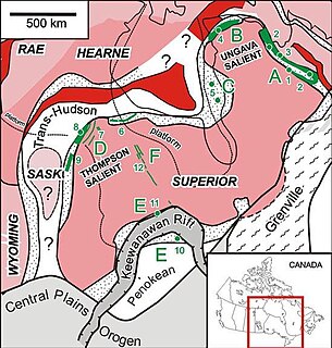
WThe Circum-Superior Belt is a widespread Paleoproterozoic large igneous province in the Canadian Shield of Northern, Western and Eastern Canada. It extends more than 3,400 km (2,100 mi) from northeastern Manitoba through northwestern Ontario, southern Nunavut to northern Quebec. Igneous rocks of the Circum-Superior Belt are mafic-ultramafic in composition, deposited in the Labrador Trough near Ungava Bay, the Cape Smith Belt near the southern shore of Hudson Strait and along the eastern shore of Hudson Bay in its northern portion; the Thompson and Fox River belts in the northwest and the Marquette Range Supergroup in its southern portion. The Circum Superior Belt also hosts a rare example of Proterozoic Komatiite, in the Winnipegosis komatiite belt.
 W
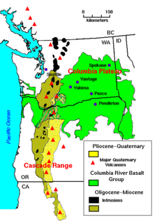
WThe Columbia Plateau is a geologic and geographic region that lies across parts of the U.S. states of Washington, Oregon, and Idaho. It is a wide flood basalt plateau between the Cascade Range and the Rocky Mountains, cut through by the Columbia River.
 W
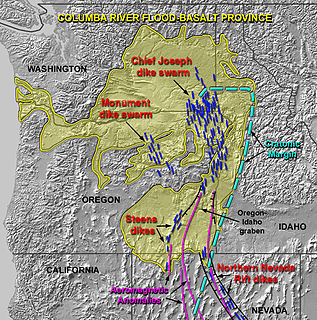
WThe Columbia River Basalt Group is the youngest, smallest and one of the best-preserved continental flood basalt province on Earth, covering over 210,000 km2 (81,000 sq mi) mainly eastern Oregon and Washington, western Idaho, and part of northern Nevada. The basalt group includes the Steen and Picture Gorge basalt formations.
 W
WThe Deccan Traps is a large igneous province of west-central India. They are one of the largest volcanic features on Earth. They consist of multiple layers of solidified flood basalt that together are more than 2,000 m (6,600 ft) thick, cover an area of c. 500,000 km2 (200,000 sq mi), and have a volume of c. 1,000,000 km3 (200,000 cu mi). Originally, the Deccan Traps may have covered c. 1,500,000 km2 (600,000 sq mi), with a correspondingly larger original volume.
 W
WThe Drakensberg is the name given to the eastern portion of the Great Escarpment, which encloses the central Southern African plateau. The Great Escarpment reaches its greatest elevation – 2,000 to 3,482 metres within the border region of South Africa and Lesotho.
 W
WThe Ethiopia-Yemen Continental Flood Basalts were erupted during the Oligocene. They cover an area of about 600,000 km2 in Yemen and Ethiopia, with an estimated volume of greater than 350,000 km3. They are associated with the Afar Plume and the initiation of rifting in the southern Red Sea and Gulf of Aden.
 W
WThe Ethiopian Highlands is a rugged mass of mountains in Ethiopia, situated in northeast part of Africa. It forms the largest continuous area of its elevation in the continent, with little of its surface falling below 1,500 m (4,900 ft), while the summits reach heights of up to 4,550 m (14,930 ft). It is sometimes called the Roof of Africa due to its height and large area. Most of the Ethiopian Highlands are part of central and northern Ethiopia, and its northernmost portion reaches into Eritrea.
 W
WThe Franklin Large Igneous Province is a Neoproterozoic large igneous province in the Canadian Arctic of Northern Canada. It represents one of the largest large igneous provinces in Canada, consisting of the Natkusiak flood basalts on Victoria Island, the Coronation sills on the southern shore of the Coronation Gulf and the large Franklin dike swarm, which extends for more than 1,200 km (750 mi) across the Canadian Arctic Archipelago and northwestern Greenland. The Franklin Large Igneous Province covers an area of more than 1,100,000 km2 (420,000 sq mi).
 W
WThe Hikurangi Plateau is an oceanic plateau in the South Pacific Ocean east of the North Island of New Zealand. It is part of a large igneous province (LIP) together with Manihiki and Ontong Java, now located 3,000 km (1,900 mi) and 3,500 km (2,200 mi) north of Hikurangi respectively. Mount Hikurangi, in Māori mythology the first part of the North Island to emerge from the ocean, gave its name to the plateau.
 W
WThe Iceland Plateau or Icelandic Plateau is an oceanic plateau in the North Atlantic Ocean consisting of Iceland and its contiguous shelf and marginal slopes. It resides on an active rift zone of the Mid-Atlantic Ridge from which extensive tholeiitic plateau basalts and a number of large rhyolitic domes have been extruded.
 W
WThe Kerguelen Plateau, also known as the Kerguelen–Heard Plateau, is an oceanic plateau and a large igneous province (LIP) located on the Antarctic Plate, in the southern Indian Ocean. It is about 3,000 km (1,900 mi) to the southwest of Australia and is nearly three times the size of Japan. The plateau extends for more than 2,200 km (1,400 mi) in a northwest–southeast direction and lies in deep water.
 W
WThe Madagascar flood basalt, also known as the Madagascar large igneous province (LIP), is one of the major magmatic events of the Late Cretaceous. They cover a large area of basaltic and rhyolitic lava flows that erupted during an episode of widespread basaltic volcanism during the Cretaceous period. The flood basalts are characterized by lava flows, dykes, sills, and intrusions, and other volcanic features include plugs, scoria, and spatter cones. Tholeiitic basalt constitutes the primary rock type.
 W
WThe Manihiki Plateau is an oceanic plateau in the south-west Pacific Ocean. The Manihiki Plateau was formed by volcanic activity 125 to 120 million years ago during the mid-Cretaceous period at a triple junction plate boundary called the Tongareva triple junction. 125 million years ago the Manihiki Plateau formed part of the giant Ontong Java-Manihiki-Hikurangi plateau.
 W
WThe Midcontinent Rift System (MRS) or Keweenawan Rift is a 2,000 km (1,200 mi) long geological rift in the center of the North American continent and south-central part of the North American plate. It formed when the continent's core, the North American craton, began to split apart during the Mesoproterozoic era of the Precambrian, about 1.1 billion years ago. The rift failed, leaving behind thick layers of igneous rock that are exposed in its northern reaches, but buried beneath later sedimentary formations along most of its western and eastern arms. Those arms meet at Lake Superior, which is contained within the rift valley. The lake's north shore in Ontario and Minnesota defines the northern arc of the rift. From the lake, the rift's eastern arm trends south to central lower Michigan, and possibly into Indiana, Ohio, Kentucky, Tennessee, and Alabama. The western arm runs from Lake Superior southwest through portions of Wisconsin, Minnesota, Iowa, and Nebraska to northeastern Kansas, and possibly into Oklahoma.
 W
WThe North Atlantic Igneous Province (NAIP) is a large igneous province in the North Atlantic, centered on Iceland. In the Paleogene, the province formed the Thulean Plateau, a large basaltic lava plain, which extended over at least 1.3 million km2 (500 thousand sq mi) in area and 6.6 million km3 (1.6 million cu mi) in volume. The plateau was broken up during the opening of the North Atlantic Ocean leaving remnants existing in Northern Ireland, bits of western Scotland, the Faroe Islands, bits of northwestern Iceland, eastern Greenland and western Norway and many of the islands located in the north eastern portion of the North Atlantic Ocean. The igneous province is the origin of the Giant's Causeway and Fingal's Cave. The province is also known as Brito-Arctic province and the portion of the province in the British Isles is also called the British Tertiary Volcanic Province or British Tertiary Igneous Province.
 W
WThe Northeast Georgia Rise is an oceanic plateau located in the South Atlantic Ocean northeast of South Georgia Island and west of the Falkland Plateau.
 W
WThe Ontong Java Plateau (OJP) is a huge oceanic plateau located in the southwestern Pacific Ocean, north of the Solomon Islands. The OJP was emplaced around 120 million years ago (Ma) with a much smaller volcanic event around 90 Ma. Two other southwestern Pacific plateaus, Manihiki and Hikurangi, now separated from the OJP by Cretaceous oceanic basins, are of similar age and composition and probably formed as a single plateau and a contiguous large igneous province together with the OJP. When emplaced this Ontong Java–Manihiki–Hikurangi plateau covered 1% of Earth's surface and represented a volume of 80 million km3 (19 million cu mi) of basaltic magma. This "Ontong Java event", first proposed in 1991, represents the largest volcanic event of the past 200 million years, with a magma emplacement rate estimated at up to 22 km3 (5.3 cu mi) per year over 3 million years, several times larger than the Deccan Traps. The smooth surface of the OJP is punctuated by seamounts such as the Ontong Java Atoll, one of the largest atolls in the world.
 W
WThe Panjal Traps or the Tethyan Plume is a large igneous province (LIP) that erupted during the Early–Middle Permian in what is now north-western India. The Panjal Traps are associated with the opening of the Neo-Tethys Ocean, which resulted in the dispersal of the Cimmerian continental blocks from the north-eastern margin of Gondwana and possibly the break-up of this old and large continent. In the Zanskar-Spliti-Lahaul area the 30–150 m (98–492 ft)-thick basalts of the Panjal Traps are mostly exposed as massive (terrestrial) lava flows, but also as (marine) pillow lavas and hyaloclastites.
 W
WThe Paraná-Etendeka traps (or Paraná and Etendeka Plateau; or Paraná and Etendeka Province) comprise a large igneous province that includes both the main Paraná traps (in Paraná Basin, a South American geological basin) as well as the smaller severed portions of the flood basalts at the Etendeka traps (in northwest Namibia and southwest Angola). The original basalt flows occurred 138 to 128 million years ago. The province had a post-flow surface area of 1,500,000 square kilometres (580,000 sq mi) and an original volume projected to be in excess of 2.3 x 10⁶ km³.
 W
WThe Shatsky Rise is Earth's third largest oceanic plateau, located in the north-west Pacific Ocean 1,500 km (930 mi) east of Japan. It is one of a series of Pacific Cretaceous large igneous provinces (LIPs) together with Hess Rise, Magellan Rise, and Ontong Java-Manihiki-Hikurangi. It was named for Nikolay Shatsky (1895-1960), a Soviet geologist, expert in tectonics of ancient platforms.
 W
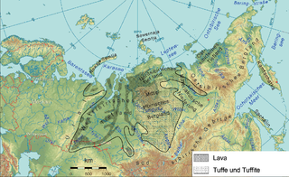
WThe Siberian Traps is a large region of volcanic rock, known as a large igneous province, in Siberia, Russia. The massive eruptive event that formed the traps is one of the largest known volcanic events in the last 500 million years.
 W
WThe Sverdrup Basin Magmatic Province is a large igneous province located on Axel Heiberg Island and Ellesmere Island, Nunavut, Canada near the rifted margin of the Arctic Ocean at the end of Alpha Ridge.
 W
WThis timeline of volcanism on Earth includes a list of major volcanic eruptions of approximately at least magnitude 6 on the Volcanic Explosivity Index (VEI) or equivalent sulfur dioxide emission during the Quaternary period. Other volcanic eruptions are also listed.
 W
WThe Wrangellia Terrane is a terrane extending from the south-central part of Alaska through southwestern Yukon and along the Coast of British Columbia in Canada. Some geologists contend that Wrangellia extends southward to Oregon, although this is not generally accepted.