 W
WThe Nantahala National Forest, established in 1920, is a national forest located in the American state of North Carolina. The word "Nantahala" is a Cherokee word, meaning "Land of the Noonday Sun." In some spots, the sun reaches the floors of the deep gorges of the forest only when it is high overhead at midday. This was part of the homeland of the historic Cherokee and their indigenous ancestors, who have occupied the region for thousands of years.
The Appalachian National Scenic Trail, generally known as the Appalachian Trail or simply the A.T., is a marked hiking trail in the Eastern United States extending between Springer Mountain in Georgia and Mount Katahdin in Maine. The trail is about 2,200 miles (3,500 km) long, though the exact length changes over time as parts are rerouted or modified. The Appalachian Trail Conservancy describes the Appalachian Trail as the longest hiking-only trail in the world. More than 2 million people are said to take a hike on part of the trail at least once each year.
 W
WThe Bartram Trail follows the approximate route of 18th-century naturalist William Bartram’s southern journey from March 1773 to January 1777. Bartram explored much of the territory which is now the states of North and South Carolina, Georgia, Florida, Alabama, Mississippi, Louisiana and Tennessee.
 W
WThe Benton MacKaye Trail or BMT is a footpath nearly 300 miles (480 km) in length in the Appalachian Mountains in the southeastern United States and is blazed by a white diamond, 5″ across by 7″ tall. The hiking trail was created and is maintained by the Benton MacKaye Trail Association, and it is named for Benton MacKaye, the Massachusetts forester and regional planner who first had the idea for the Appalachian Trail in 1921.
 W
WBob Stratton Bald, often referred to as Stratton Bald, is a grassy bald in the Unicoi Mountains located in the Joyce Kilmer-Slickrock Wilderness in the Nantahala National Forest. Its elevation is approximately 5,360 feet.
 W
WBridal Veil Falls is a 45-foot (13.7 m) waterfall located in the Nantahala National Forest, northwest of Highlands, North Carolina. With a short curve of roadway located behind the falls, it had the distinction of being the only waterfall in the state that one could drive a vehicle under, however this has since been closed and is now used for pedestrian access only.
 W
WBull Cove Falls is a waterfall located in the southwestern Appalachian Mountains in North Carolina.
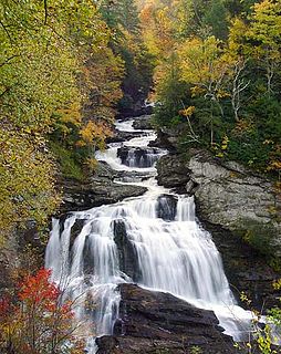
WCullasaja Falls is a waterfall in southwestern North Carolina. The waterfall is located on the Cullasaja River in the Nantahala National Forest and is part of the Mountain Waters Scenic Byway. Cullasaja comes from a Cherokee word meaning "honey locust place".
 W
WThe Cullasaja River is a short river located entirely in Macon County, North Carolina. It is a tributary of the Little Tennessee River, into which it flows near the county seat of Franklin. It originates to the southeast, near Highlands, the county's only other town. It flows from manmade Lake Sequoyah, which is fed by Mirror Lake and other creeks and streams originating on the western side of the Eastern Continental Divide, which runs through the east side of Highlands.
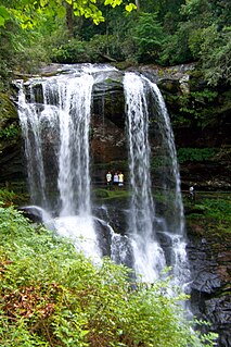
WDry Falls, also known as Upper Cullasaja Falls, is a 65-foot waterfall located in the Nantahala National Forest, northwest of Highlands, North Carolina.
 W
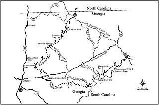
WEllicott Rock Wilderness is managed by the United States Forest Service and is part of the National Wilderness Preservation System. It was first designated by Congress in 1975 with the Eastern Wilderness Act. The majority of this land lays in South Carolina. Additional lands were added to Ellicott Rock Wilderness in 1984 with the passing of the North Carolina Wilderness Act and the Georgia Wilderness Act, today designated wilderness totals 8,274 acres (33.48 km2). Ellicott Rock Wilderness is the only wilderness that straddles three states, with boundaries located around the point at which Georgia, North Carolina, and South Carolina come together. Ellicott Rock Wilderness also spans three National Forests. Sumter National Forest in South Carolina is responsible for 2,859 acres (11.57 km2), receives the majority of recreation in the wilderness, and is also the lead manager of Ellicott Rock Wilderness. Nantahala National Forest in North Carolina is responsible for the majority of the wilderness at 3,394 acres (13.74 km2) and the Chattahoochee National Forest in Georgia manages 2,021 acres (8.18 km2) of the wilderness. In 1979, all Forest Service land was surveyed under the Roadless Area Review and Evaluation and 1,982 acres (8.02 km2) on the Sumter National Forest were classified as Roadless National Forest System land and named Ellicott Rock Extension. The Andrew Pickens Ranger district on the Sumter National Forest recommended the Ellicott Rock Extension as wilderness in 1995 in their Resource Management Plan. Although not fully designated, recommended wilderness is managed as if it were designated wilderness. In June 2017 during a land management plan revision, the Nantahala Ranger District on the Nantahala National Forest added 824 acres (3.33 km2) of proposed wilderness, currently called Ellicott Rock West Extension.
 W
WFires Creek is a recreational area located in the Nantahala National Forest in Clay County, North Carolina. It takes its name from Fires Creek, which runs through it. The area offers paved and unpaved hiking trails, swimming holes, camping spots, picnic tables, grills, scenic views, horseback riding, fishing.
 W
WFontana Lake is a reservoir impounded by Fontana Dam on the Little Tennessee River located in Graham and Swain counties in North Carolina. The lake forms part of the southern border of Great Smoky Mountains National Park and the northern border of part of the Nantahala National Forest. Depending on water levels, the lake is about 17 miles (27 km) long. The eastern end is the Tuckasegee River near Bryson City. It has an average depth of 135 feet (41 m) and reaches a maximum depth of 440 feet (130 m), making it the deepest lake in North Carolina. The lake has many inlets into coves and many islands formed from former mountain peaks, especially near the eastern end. As with most dam-impounded lakes, the steep banks are exposed when water levels are low. Many towns were submerged shortly after the creation of Fontana Lake, such as Proctor and Judson.
 W
WThe Foothills Trail is a 76-mile (122 km) National Recreation Trail in South and North Carolina, United States, for recreational hiking and backpacking. It extends from Table Rock State Park to Oconee State Park. It passes through the Andrew Pickens Ranger District of the Sumter National Forest, Ellicott Rock Wilderness, Whitewater Falls, and Lake Jocassee.
 W
WHiwassee is a small village in Cherokee County, North Carolina, which sits next to the Hiwassee Dam and the artificially created Hiwassee Reservoir, on Hiwassee River.
 W
WHooper Bald is a grassy bald mountain in the Unicoi Mountain Range located in the Cheoah Ranger District of Nantahala National Forest in Graham County, North Carolina, United States. The summit is 5,429 ft/1,655 m.
 W
WJoyce Kilmer Memorial Forest is an approximately 3,800-acre tract of publicly owned virgin forest in Graham County, North Carolina, named in memory of poet Joyce Kilmer (1886–1918), best known for his poem "Trees". One of the largest contiguous tracts of old growth forest in the Eastern United States, the area is administered by the U. S. Forest Service. The memorial forest is a popular family hiking destination and features an easy two-mile, figure-eight trail that includes a memorial plaque at the juncture of the two loops. In 1975 the memorial forest was joined with a much larger tract of the Nantahala National Forest to become part of the Joyce Kilmer-Slickrock Wilderness.
 W
WJoyce Kilmer-Slickrock Wilderness, created in 1975, covers 17,394 acres (70 km2) in the Nantahala National Forest in western North Carolina and the Cherokee National Forest in eastern Tennessee, in the watersheds of the Slickrock and Little Santeetlah Creeks. It is named after Joyce Kilmer, author of "Trees." The Little Santeetlah and Slickrock watersheds contain 5,926 acres (23.98 km2) of old growth forest, one of the largest tracts in the United States east of the Mississippi River.
WLake Glenville is a reservoir located 8 miles from Cashiers, North Carolina to the dam and public beach. The headwaters, at Hurricane Creek, are less than 2 miles. It was formed by the damming of the west fork of the Tuckasegee River in 1941. Between 1951 and 2002, it was officially known as "Thorpe Reservoir" after J. E. S. Thorpe, Nantahala Power's first president. It is still listed as such on many maps. The lake bottom plunges as steeply as the mountains that meet the shore. The depth a short distance from the water's edge may register 80 feet (24 m) or more. The lake has 26 miles (42 km) of shoreline and encompasses 1450 total acres. It is only a short twenty-minute drive from Western Carolina University, and the town of Sylva.
 W
WThe Mountains-to-Sea State Trail (MST) is a long-distance trail for hiking and backpacking, that traverses North Carolina from the Great Smoky Mountains to the Outer Banks. The trail's western endpoint is at Clingman's Dome, where it connects to the Appalachian Trail in the Great Smoky Mountains National Park. Its eastern endpoint is in Jockey's Ridge State Park on the tallest sand dune on the east coast. The trail is envisioned as a scenic backbone of an interconnected trail system spanning the state. As such, the trail's route attempts to connect as many trail systems and natural scenic areas as practicable. A little over half of the trail is complete in multiple segments across the state.
 W
WRainbow Falls is a waterfall in Western North Carolina, located near Brevard. The falls is located on the Horsepasture River. It is on Pisgah National Forest land just outside Gorges State Park.
 W
WSilver Run Falls is a 20-foot waterfall a few miles from the town of Cashiers, North Carolina. It is popular with locals and tourists alike. The falls are located after a flat, 200 yard trail. Additionally, there is a second secret falls located above Silver Run. On the left side of the cliff face of the falls, just inside the woods, there is a slope of granite with many roots for handholds leading to the top of the falls. Follow the trail up top until you hear the second falls on your right.
 W
WThe Southern Highroads Trail is a 364-mile-long (586 km) loop of scenic and historic highways in the Southeastern United States. The driving trail traverses 14 counties, four states, and four national forests, providing sightseers and passersby an array of culinary, hotel, shopping, and recreational options along the way.
 W
WThe Southern Nantahala Wilderness was designated in 1984 and currently consists of 23,473 acres (94.99 km2). Approximately 11,770 acres (47.6 km2) are located in Georgia in the Chattahoochee National Forest and approximately 11,703 acres (47.36 km2) are located in North Carolina in the Nantahala National Forest. The Wilderness is managed by the United States Forest Service and is part of the National Wilderness Preservation System. The highest elevation in the Southern Nantahala Wilderness is the 5,499-foot peak of Standing Indian Mountain in North Carolina and the lowest elevation is approximately 2,400 feet (730 m). The Appalachian Trail passes through the Wilderness in both states.
 W
WStanding Indian Mountain, elevation 5,499 feet, is part of the North Carolina portion of the Southern Nantahala Wilderness within the boundaries of the Nantahala National Forest. The mountain lies along the Appalachian Trail and is the highest point along the Nantahala River.
 W
WUpper Whitewater Falls is a waterfall in North Carolina on the Whitewater River. As with most of North Carolina's waterfalls, it is in the mountainous area of the state. There is a cluster of falls in the area where the borders of Georgia and the Carolinas come together. Whitewater Falls is part of that group, very close to the South Carolina border.
 W
WWayah Bald is a high-altitude treeless open area in Nantahala National Forest, near Franklin, North Carolina. The Wayah Bald Observation Tower is located at the area's highest point ; the stone observation tower was built by the Civilian Conservation Corps in 1937 for fire detection. The Appalachian Trail and Bartram Trail cross at Wayah Bald.
 W
WWesser Bald is a summit located in Macon County, North Carolina, near the community of Wesser. A wooden fire tower at the summit provides hikers with unimpeded views of the Great Smoky Mountains National Park and also the Nantahala Mountains. The Appalachian Trail traverses the summit from roughly north to south with the Nantahala Outdoor Center lying to the north within the Nantahala Gorge and Tellico gap just to the south. Tellico gap has unimproved road access. The climb from Tellico Gap takes an average of 20 minutes. Also, a third route, the blue trail, departs from the end of Wesser Creek Road and follows Wesser Creek up to a point just south of the summit to a fork with the Appalachian Trail. The summit is located at 4,627 ft (1,410 m). and is within Nantahala National Forest. A map detailing the highway routes to access Tellico Gap is available at the Nantahala Outdoor Center. Observable landforms include Wayah Bald, the Nantahala Gorge, and Clingmans Dome among others. The Wesser Fire Tower provides unparalleled 360 degree views of the Smokies in a short 1.5 mile hike from Tellico Gap on the Appalachian Trail, with an elevation gain of about 767 feet. The Fire Tower was originally reported as destroyed during the forest fires which ravaged the Nantahala Forest in November, 2016 but it was later learned that it survived.
WThe Whitewater River is a 14.6-mile-long (23.5 km) river that flows south from headwaters in Transylvania County, North Carolina, over Upper Whitewater Falls and Lower Whitewater Falls before crossing into South Carolina and entering Lake Jocassee, the reservoir behind Lake Jocassee Dam.
 W
W