 W
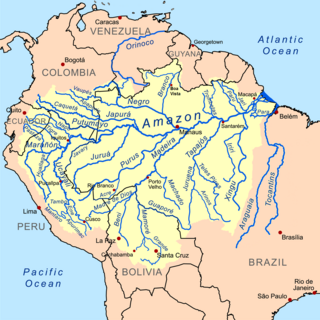
WThe Amazon Basin is the part of South America drained by the Amazon River and its tributaries. The Amazon drainage basin covers an area of about 6,300,000 km2 (2,400,000 sq mi), or about 35.5 percent of the South American continent. It is located in the countries of Bolivia, Brazil, Colombia, Ecuador, French Guiana (France), Guyana, Peru, Suriname, and Venezuela.
 W
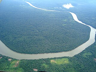
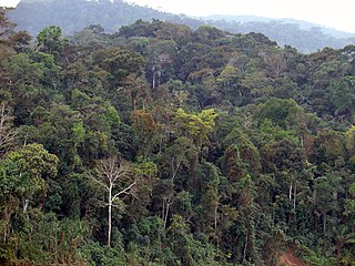
WThe Amazon biome contains the Amazon rainforest, an area of tropical rainforest, and other ecoregions that cover most of the Amazon basin and some adjacent areas to the north and east. The biome contains blackwater and whitewater flooded forest, lowland and montane terra firme forest, bamboo and palm forest, savanna, sandy heath and alpine tundra. Some areas are threatened by deforestation for timber and to make way for pasture or soybean plantations.
The Amazon Cooperation Treaty Organization (ACTO) is an international organization aimed at the promotion of sustainable development of the Amazon Basin. Its member states are: Bolivia, Brazil, Colombia, Ecuador, Guyana, Peru, Suriname and Venezuela.
 W
WAmazonía region in southern Colombia comprises the departments of Amazonas, Caquetá, Guainía, Guaviare, Putumayo and Vaupés, and covers an area of 483,000 km², 35% of Colombia's total territory. The region is mostly covered by tropical rainforest, or jungle, which is a part of the massive Amazon rainforest.
 W
WThe Amazon River in South America is the largest river by discharge volume of water in the world, and the disputed longest river in the world.
 W
WThe Amazon Rubber Boom was an important part of the economic and social history of Brazil and Amazonian regions of neighboring countries, being related to the extraction and commercialization of rubber. Centered in the Amazon Basin, the boom resulted in a large expansion of European colonization in the area, attracting immigrant workers, generating wealth, causing cultural and social transformations, and wreaking havoc upon indigenous societies. It encouraged the growth of cities such as Manaus and Belém, capitals within the respective Brazilian states of Amazonas and Pará, among many other cities throughout the region like Itacoatiara, Rio Branco, Eirunepé, Marabá, Cruzeiro do Sul and Altamira; as well as the expansion of Iquitos in Peru and Cobija in Bolivia. The rubber boom occurred largely between 1879 and 1912. There was heightened rubber production and associated activities again from 1942 to 1945 during the Second World War.
 W
WThe Amazon Tall Tower Observatory or ATTO is a scientific research facility in the Amazon rainforest of Brazil. Infrastructure includes a 325 metres (1,066 ft) tall tower that extends far above the forest canopy and two smaller towers that allow researchers to collect samples from the soil surface to above the forest canopy. Additionally, there are container-labs, a base camp and nearby sites for studying vegetation and soil processes. The tall research tower is one meter taller than the Eiffel Tower and is currently the tallest structure in South America. The two further towers are 80 metres (260 ft) in height. All towers are equipped with a broad range of instruments to measure chemical and physical properties of the atmosphere, such as greenhouse gas concentrations, aerosols and meteorological data.
Amazon Watch is a nonprofit organization founded in 1996, and based in Oakland, California, it works to protect the rainforest and advance the rights of indigenous peoples in the Amazon Basin. It partners with indigenous and environmental organizations in Ecuador, Peru, Colombia and Brazil in campaigns for human rights, corporate accountability and the preservation of the Amazon's ecological systems.
 W
WThe Amazonas National Forest is a national forest in the state of Amazonas, Brazil.
 W
WAmazônia Legal, also known as Brazil's Legal Amazon or BLA, is the largest socio-geographic division in Brazil, containing all nine states in the Amazon basin. The government designated this region in 1948 based on its studies on how to plan the economic and social development of the Amazon region.
 W
WAmazonian languages is the term used to refer to the indigenous languages of "Greater Amazonia." This area is significantly larger than the Amazon and extends from the Atlantic coast all the way to the Andes, while its southern border is usually said to be the Paraná. The region is inhabited by societies that share many cultural traits but whose languages are characterized by great diversity. There are about 330 extant languages in Greater Amazonia, almost half of which have fewer than 500 speakers. Meanwhile, only Wayuu has greater than 100,000 speakers. Of the 330 total languages, about fifty are isolates, while the remaining ones belong to about 25 different families. Most of the posited families have few members. It is this distribution of many small and historically unrelated speech communities that makes Amazonia one of the most linguistically diverse regions in the world. The precise reasons for this unusual diversity have not yet been conclusively determined, but Amazonian languages seem to have had fewer than 10,000 native speakers even before the invasion of European colonists wrought havoc on the societies by which they were spoken. Despite the large-scale diversity, the long-term contact among many of the languages of Greater Amazonia has created similarities between many neighboring languages that are not genetically related. Most indigenous Amazonian people today are bilingual or even monolingual in Spanish or Portuguese, and many Amazonian languages are endangered as a result.
 W
WBelterra is a municipal seat and rubber plantation site some 40 km (25 mi) south of the city of Santarém, Brazil at the edge of the Planalto at 165 m (541 ft) above sea level.
 W
WThe Cerro de la Sal or Cerro de Sal, is located in Villa Rica District of Oxapampa Province in Pasco Department, Peru. The Cerro de la Sal was an important source of salt for the pre-Columbian Indigenous people of the Amazon Basin in Peru. Because of the seasonal concentration at the mountain by indigenous people (Indians), especially the Asháninka and Yanesha (Amuesha), Spanish missionaries, settlers, and soldiers were attracted to the Cerro de la Sal as early as 1635. Several attempts by Franciscan missionaries to establish Roman Catholic missions in the area were thwarted by uprisings of the indigenous people. In the late 19th century the Spanish established a foothold leading to the settlement of Europeans and Andean peoples in the area.
Coordinator of Indigenous Organizations of the Amazon River Basin (COICA) was founded in 1984 in Lima, Peru. This organization coordinates the following nine national Amazonian indigenous organizations:Asociación Interétnica de Desarrollo de la Selva Peruana (AIDESEP) Amerindian People's Association of Guyana (APA) Confederación de Pueblos Indígenas de Bolivia (CIDOB) Coordenação das Organizações Indígenas da Amazônia Brasileira (COIAB) Confederation of Indigenous Nationalities of the Ecuadorian Amazonia (CONFENIAE) Regional Organization of Indigenous Towns of the Amazon (ORPIA) Federation des Organisations Amerindiennes de Guyane (FOAG) Organization Van Inheemsen in Suriname (OIS) Organization of the Indigenous Towns of the Colombian Amazonia
 W
WCursed for Gold is a 2008 French documentary film written and directed by the French writer and novelist Olivier Weber, former war correspondent, dealing with the new gold rush destroying the Amazon rainforest.
 W
WThe flying river is a movement of large quantities of water vapor transported in the atmosphere from the Amazon Basin to other parts of South America. The forest trees release water vapor into the atmosphere through transpiration and this moisture is deposited in other localities in the form of precipitation, forming a virtual river.[text]
 W
WLake Junin or Chinchaycocha is the largest lake entirely within Peruvian territory. Even though Lake Titicaca has a much larger area, its eastern half is located on Bolivian territory. Lake Junin is an important birdwatching destination in the country.
 W
WLake Pilchicocha is a „blackwatered“ lake, in the Province of Sucumbíos of Ecuador. It is located in the eastern Ecuadorian Amazon Basin, and about 2.1 Miles (1,3 km) from the Napo River. The fish population consists mainly of Scavenger-Piranhas.
WThe Amazon River in South America is the largest river by discharge volume of water in the world, and the disputed longest river in the world.
 W
WThe Marajoara or Marajó culture was a pre-Columbian era society that flourished on Marajó island at the mouth of the Amazon River in northern Brazil. In a survey, Charles C. Mann suggests the culture appeared to flourish between 800 AD and 1400 AD, based on archeological studies. Researchers have documented that there was human activity at these sites as early as 1000 BC. The culture seems to have persisted into the colonial era.
 W
WThe National Institute of Amazonian Research is a public educational and research institution headquartered in Manaus, Brazil. It was founded in 1952, with the purpose of furthering scientific knowledge of the Brazilian Amazon Region. Most of INPA's research focuses on tropical forest management, ecology, molecular ecology, zoology, botany, tropical agriculture and tropical pisciculture. The institution also maintains important vertebrate, invertebrate, and vascular plants research collections.
WThe Northern Amazon Ecological Corridor is a proposed ecological corridor connecting conservation units and indigenous territories in the north of the Amazon rainforest of Brazil.
 W
WPeruvian Amazonia is the area of the Amazon rainforest included within the country of Peru, from east of the Andes to the borders with Ecuador, Colombia, Brazil and Bolivia. This region comprises 60% of the country and is marked by a large degree of biodiversity. Peru has the second-largest portion of the Amazon rainforest after the Brazilian Amazon.
 W
WThe Amazon rainforest, alternatively, the Amazon Jungle, also known in English as Amazonia, is a moist broadleaf tropical rainforest in the Amazon biome that covers most of the Amazon basin of South America. This basin encompasses 7,000,000 km2 (2,700,000 sq mi), of which 5,500,000 km2 (2,100,000 sq mi) are covered by the rainforest. This region includes territory belonging to nine nations.
 W
WThe Rio Negro, or Guainía as it is known in its upper part, is the largest left tributary of the Amazon River, the largest blackwater river in the world, and one of the world's ten largest rivers by average discharge.
WThe Roraima National Forest is a national forest in the state of Roraima, Brazil.
 W
WA sand forest is a type of rare subtropical forest region, distinctive due to its unique combination of plant and animal species, and their restriction to ancient coastal dunes. Sand forests are found in Maputaland in South Africa, as well as parts of the Amazon basin in Brazil, Peru, and Colombia.
 W
WThe Sucunduri Formation is a Neoproterozoic geologic formation in Brazil. While reports made in the 1950s state that dinosaur remains were among the fossils that have been recovered from the formation, none of which referred to a specific genus, later research has questioned this interpretation. The formation crops out in Amazonas.
 W
WTerra preta is a type of very dark, fertile artificial (anthropogenic) soil found in the Amazon Basin. It is also known as "Amazonian dark earth" or "Indian black earth". In Portuguese its full name is terra preta do índio or terra preta de índio. Terra mulata is lighter or brownish in color.
 W
WThe Trans-Amazonian Highway, was introduced on September 27, 1972. It is 4,000 km long, making it the third longest highway in Brazil. It runs through the Amazon forest and the Brazilian states of Paraíba, Ceará, Piaui, Maranhão, Tocantins, Pará and Amazonas, from the proximities of Saboeiro up until the town of Lábrea.
WThe Amazon River in South America is the largest river by discharge volume of water in the world, and the disputed longest river in the world.