 W
WCappadocia is a historical region in Central Anatolia, largely in the Nevşehir, Kayseri, Kırşehir, Aksaray, Malatya, Sivas and Niğde provinces in Turkey.
 W
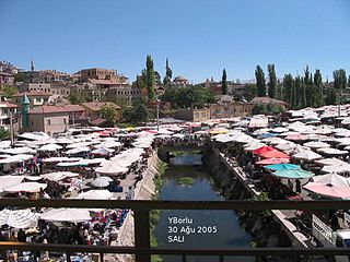
WAvanos is a town and district of Nevşehir Province in the Central Anatolia region of Turkey, located 18 km (11 mi) north of Nevşehir, the capital city of the province. It is situated within the historic and tourist region of Cappadocia. According to 2000 census, population of the district is 35,145 of which 12,288 live in the town of Avanos. The district covers an area of 994 km2 (384 sq mi), and the average elevation is 920 m (3,018 ft), with the highest point being Mt. İsmail Sivrisi at 1,756 m (5,761 ft).
 W
WBor is a town and district of Niğde Province in the Central Anatolia region of Turkey, 14 km (8.7 mi) to the southeast of the city of Niğde, on a high plain. The district's population is 59,919 of which 38,320 live in the town of Bor.
 W
WÇamardı is a quiet town and district of Niğde Province in the Central Anatolia region of Turkey, at the foot of Aladağ in the Taurus Mountains and reached by winding mountain roads. Population is 15,245 of which 3,396 live in the town of Çamardı. Çamardı is well known with its being very green in the summer. Many people come to Çamardı in order to spend their summer holidays in a green and quiet place. Çamardı is one of the gross producers of apple. You can find many kinds of apples in Çamardı. Also, in the last couple of years, cherry becomes one of the few mainstays of Çamardı. One of the well known families of Çamardı is the Köse Family.
 W
WCappadocian Greeks also known as Greek Cappadocians or simply Cappadocians are a Greek community native to the geographical region of Cappadocia in central-eastern Anatolia, roughly the Nevşehir Province and surrounding provinces of modern Turkey. There had been a continuous Greek presence in Cappadocia since antiquity, and the indigenous populations of Cappadocia, some of whose Indo-European languages may have been closely related to Greek, became entirely Greek-speaking by at least the 5th century. In the 11th century Seljuq Turks arriving from Central Asia conquered the region, beginning its gradual shift in language and religion. According to 1897 estimations, the sanjak of Konya had a total Greek population of 68.101 and according to Ottoman population statistics of 1914, the sanjak of Niğde had a total Greek population of 58.312 and the sanjak of Kayseri had a total of 26.590.In 1923 following the genocide of the minorities of Turkey the surviving Cappadocian Greek native communities were forced to leave their homeland and resettle in modern Greece by the terms of the Greek–Turkish population exchange. Today their descendants can be found throughout Greece and the Greek diaspora worldwide.
 W
WÇavuşin is a village in the district of Avanos in Nevşehir Province in the Cappadocia region of Turkey. It is on the road between Avanos and Göreme, about five kilometers north of Göreme.
 W
WÇiftlik is a town and district of Niğde Province in the Central Anatolia region of Turkey, 67 km from the town of Niğde, and 65 km from Aksaray. There is a much shorter route over the mountains to Niğde but that road is often under snow and closed in winter. Population is (2010) 29,183 of which 3,304 live in the town of Çiftlik.
 W
WDerinkuyu is a town and district of Nevşehir Province in the Central Anatolia region of Turkey. According to 2010 census, population of the district is 22,114 of which 10,679 live in the town of Derinkuyu. The district covers an area of 445 km2 (172 sq mi), and the average elevation is 1,300 m (4,265 ft), with the highest point being Mt. Ertaş at 1,988 m (6,522 ft).
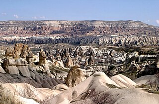
Göreme is a district of the Nevşehir Province in Turkey. After the eruption of Mount Erciyes about 2.6 million years ago, ash and lava formed soft rocks in the Cappadocia Region, covering a region of about 20,000 square kilometres (7,700 sq mi). The softer rock was eroded by wind and water, leaving the hard cap rock on top of pillars, forming the present-day fairy chimneys. People of Göreme, at the heart of the Cappadocia Region, realized that these soft rocks could be easily carved out to form houses, churches, and monasteries. These Christian sanctuaries contain many examples of Byzantine art from the post-iconoclastic period. These frescos are a unique artistic achievement from this period.
 W
WGöreme, located among the "fairy chimney" rock formations, is a town in Cappadocia, a historical region of Turkey. It is in the Nevşehir Province in Central Anatolia and has a population of around 2,000 people.
WGösterli is a village in North-East Niğde. It is also located at the South-West part of historical site Cappadocia. The population was 1,711 at the 2009 census.
 W
WGülşehir, formerly Aravissos and Arapsun, ancient Zoropassos, is a town and district of Nevşehir Province in the Central Anatolia region of Turkey, in the vicinity of the Fairy Chimney valley of Göreme. According to 2010 census, population of the district is 24,503 of which 8,866 live in the town of Gülşehir, and the remainder in surrounding villages. The district covers an area of 956 km2 (369 sq mi), and the average elevation is 885 m (2,904 ft).
WHasangazi is a village of the district Ulukışla in the Central Anatolia region of Turkey. Located 16 km east of Ulukışla and 70 km south of Nigde, the village has a population of 887.
 W
WA hoodoo is a tall, thin spire of rock that protrudes from the bottom of an arid drainage basin or badland. Hoodoos typically consist of relatively soft rock topped by harder, less easily eroded stone that protects each column from the elements. They generally form within sedimentary rock and volcanic rock formations.
 W
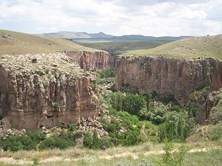
WIhlara is a township with own municipality in Aksaray Province, Central Anatolia, Turkey. It is situated at about 40 km (25 mi) from the province seat of Aksaray and near the town of Güzelyurt. The township is famed for the nearby valley of the same name, Ihlara Valley, which is a 16 km (10 mi) long gorge cut into volcanic rock in the southern part of Cappadocia, following several eruptions of Mount Erciyes. The Melendiz Stream flows through the valley.
 W
WThe Ihlara Valley is a canyon which is 15 km long and up to 150 m deep in the southwest of the Turkish region of Cappadocia, in the municipality of Güzelyurt, Aksaray Province. The valley contains around 50 rock-hewn churches and numerous rock-cut buildings.
WThe Kayakapi neighbourhood of Ürgüp, Turkey is a historical area located on the northeastern slope of a hill known as Esbelli. It features many examples of vernacular and monumental architecture, including the House of Saint John the Russian (Yuhannes). Abandoned after the 1980s, the semi-ruins and natural landscape of Kayakapi are now being developed for tourism.
 W
WKayseri is a large industrialised city in Central Anatolia, Turkey. It is the seat of Kayseri Province. The city of Kayseri, as defined by the boundaries of Kayseri Metropolitan Municipality, is structurally composed of five metropolitan districts, the two core districts of Kocasinan and Melikgazi, and since 2004, also Hacılar, İncesu and Talas.
WKozaklı, formerly Hamamorta, is a town and district of Nevşehir Province in the Central Anatolia region of Turkey. According to 2010 census, population of the district is 15,519 of which 7,011 live in the town of Kozaklı. The district covers an area of 706 km2 (273 sq mi), and the average elevation is 1,275 m (4,183 ft).
 W
WLake Tuz is the second largest lake in Turkey with its 1,665 km2 (643 sq mi) surface area and one of the largest hypersaline lakes in the world. It is located in the Central Anatolia Region, 105 km (65 mi) northeast of Konya, 150 km (93 mi) south-southeast of Ankara and 57 km (35 mi) northwest of Aksaray.
 W
WNevşehir, formerly Neapolis and Muşkara, is a city and the capital district of Nevşehir Province in the Central Anatolia Region of Turkey. According to the 2010 census, the population of the district is 117,890 of which 85,634 live in the city of Nevşehir. The district covers an area of 535 km2 (207 sq mi), and the town lies at an elevation of 1,224 m (4,016 ft).
 W
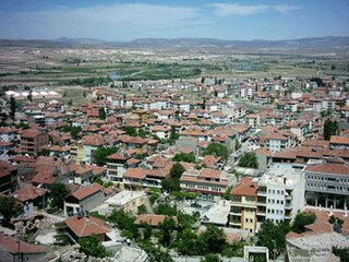
WNiğde is a town and the capital of Niğde Province in the Central Anatolia region of Turkey at an elevation of 1,299 m. In 2019 the population was 362.861
 W
WNiğde Province is a province in the southern part of Central Anatolia, Turkey. Population is 341,412 of which 141,360 live in the city of Niğde. The population was 348,081 in 2000 and 305,861 in 1990. It covers an area of 7,312 km2. Neighbouring provinces are Kayseri, Adana, Mersin, Konya, Aksaray and Nevşehir.
 W
WOrtahisar is a small town in Ürgüp district of Nevşehir Province, in Cappadocia, Turkey. Ortahisar has 14,262 inhabitants as of 2015 and is located about 20 km east of the provincial capital, Nevşehir.
 W
WRock-cut architecture in Cappadocia in Central Turkey includes living and work spaces as well as sacred buildings like churches and monasteries, that were carved out of the soft tuff landscape.
 W
WRunfire Cappadocia Ultramarathon, shortly RFC, is an international multiday ultramarathon event of desert concept that takes place mostly across the historic Cappadocia region in central Turkey. The event is run 244 km (152 mi) in the provinces Nevşehir and Aksaray in six days. The Runfire Cappadocia Ultramarathon was established in 2012 taking place on July 7–15. It is considered a race of high-degree difficulty. The event is organized by Argos Culture & Arts.
 W
WSoğanlı Valley is located in Yeşilhisar district, Kayseri Province, Turkey, in the southeastern part of the region of Cappadocia. The valley contains several rock-cut churches and other rock-cut buildings, carved from the soft tuff stone of the Cappadocian landscape.
WThe Tour of Cappadocia is an international road cycling race organized by the Turkish Cycling Federation at Cappadocia in central Turkey. It is part of the UCI Europe Tour with a rating of 2.2.
 W
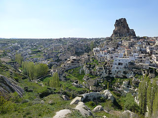
WUçhisar is a settlement in Cappadocia, in Nevşehir Province, Turkey. The town is 7 kilometres east of Nevşehir, 12 kilometres west of Ürgüp, and 10 kilometres south of Avanos.
 W
WUlukışla is a town and district of Niğde Province in the Central Anatolia region of Turkey. It covers an area of 1,502 km², and the altitude is 1,427 m. Population is 22,728 of which 5,594 live in the town of Ulukışla.
 W
WÜrgüp is a town and district of Nevşehir Province in the Central Anatolia region of Turkey. It is located in the historical region of Cappadocia, and near the cave Churches of Göreme. According to 2010 census, the population of the district is 34,372 of which 18,631 live in the town of Ürgüp. The district covers an area of 563 km2 (217 sq mi), and the town lies at an average elevation of 1,043 m (3,422 ft).