 W
WAlberni Inlet is a long, narrow inlet in Vancouver Island, British Columbia, Canada, that stretches from the Pacific Ocean at Barkley Sound about 40 km (25 mi) inland terminating at Port Alberni. It was named by the Spanish explorer Francisco de Eliza after Pedro de Alberni, Captain of the Free Company of Volunteers of Catalonia who was appointed in the Spanish fort in Nootka Sound from 1790 to 1792. The inlet includes traditional territories of the Ucluelet, Uchucklesaht, Huu-ay-aht, Hupacasath, and Tseshaht peoples, who are part of the Nuu-chah-nulth Tribal Council people.
 W
WAlice Arm is the east arm of Observatory Inlet, which itself is an arm of Portland Inlet, on the North Coast of British Columbia, Canada, near the border with the American state of Alaska. The abandoned settlement and steamer landing of Alice Arm, is located on the east side of Observatory Inlet at the mouth of the Kitsault River.
WBelize Inlet is an inlet on the Central Coast of British Columbia, Canada, located to the north of and adjoining Seymour Inlet.
 W
WBurrard Inlet is a relatively shallow-sided coastal fjord in southwestern British Columbia, Canada. Formed during the last Ice Age, it separates the City of Vancouver and the rest of the low-lying Burrard Peninsula from the slopes of the North Shore Mountains, home to the communities of West Vancouver and the City and District of North Vancouver.
 W
WBute Inlet is one of the principal inlets of the British Columbia Coast. It is 80 km (50 mi) long from the estuaries of the Homathko and Southgate Rivers at the head of the inlet, to the mouth, where it is nearly blocked by Stuart Island, and it averages about 4 km (2.5 mi) in width. Bute Inlet is in a spectacular wilderness setting and is one of the most scenic waterways in the world. In the upper reaches of the inlet mountains rise 2,700 m (9,000 ft) feet above sea level. Bute Inlet is a spectacular wilderness that is visited by very few people. In more recent years tourists are travelling from around the world to view grizzly bears in a natural setting and explore the wilderness of Bute Inlet.
 W
WDouglas Channel is one of the principal inlets of the British Columbia Coast. Its official length from the head of Kitimat Arm, where the aluminum smelter town of Kitimat to Wright Sound, on the Inside Passage ferry route, is 90 km (56 mi). The actual length of the fjord's waterway includes waters between there and the open waters of the Hecate Strait outside the coastal archipelago, comprising another 60 km (37 mi) for 140 km (87 mi)in total.
 W
WThe Gardner Canal is one of the principal inlets of the British Columbia Coast. Technically a side-inlet of the larger Douglas Channel, the Gardner Canal is still 90 km (56 mi) in length in its own right; total length of the waterways converging on the Douglas Channel is 320 km (200 mi) making it one of the largest fjord-complexes in the world.
WHastings Arm is a fjord on the North Coast of British Columbia, which is the northwest arm of Observatory Inlet, one of the two main branchings of Portland Inlet, the other being the better-known Portland Canal, which forms part of the Canada–United States border. Hastings Arm is approximately 30 km (19 mi) in length from the divergence of Observatory Inlet near the former smelting town of Anyox, where a 25 km (16 mi) east arm, Alice Arm, branches off towards its head at the mouth of the Kitsault River. This divergence is approximately 50 km (31 mi) from the mouth of Observatory Inlet itself, near Nass Bay, which is the outer part of the estuary of the Nass River. At the head of Hastings Arm is the mouth of the Kshwan River, and the Nisga'a village-site of Kswan.
 W
WHowe Sound is a roughly triangular sound, that joins a network of fjords situated immediately northwest of Vancouver, British Columbia.
 W
WIndian Arm is a steep-sided glacial fjord adjacent to the city of Vancouver in southwestern British Columbia. Formed during the last Ice Age, it extends due north from Burrard Inlet, between the communities of Belcarra and the District of North Vancouver, then on into mountainous wilderness. Burrard Inlet and the opening of Indian Arm was mapped by Captain George Vancouver and fully explored days later by Dionisio Alcalá Galiano in June 1792.
 W
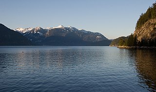
WJervis Inlet is one of the principal inlets of the British Columbia Coast, about 95 km (59 mi) northwest of Vancouver, and the third of such inlets north of the 49th parallel, the first of which is Burrard Inlet, Vancouver's harbour.
 W
WKhutzeymateen Inlet is one of the lesser principal inlets of the British Columbia Coast. It is important in being part of the first area in Canada protected to preserve grizzly bears and their habitat via the Khutzeymateen/K’tzim-a-deen Grizzly Sanctuary. The inlet and the park-sanctuary surrounding it are between the mouths of the Skeena and Nass Rivers; the Khutzeymateen is the next inlet north from Work Channel, which is the north side of the Tsimpsean Peninsula of "Greater Prince Rupert". The inlet's mouth opens onto an arm of Portland Inlet, Steamer Passage, which lies next to Sommerville Island. The entrance to Khutzeymateen Inlet is between Keemein Point and Welgeegenk Point. The closest community is Lax Kw'alaams, formerly Port Simpson.
 W
WKnight Inlet is one of the principal inlets of the British Columbia Coast, and the largest of the major inlets in the southern part of the Coast. It is fifth in sequence of the great saltwater inlets north from the 49th parallel near Vancouver, but it is the first whose outflow points away from the Strait of Georgia, opening into Queen Charlotte Strait at the Kwakwakaʼwakw community of Memkumlis on Village Island.
 W
WNarrows Inlet formerly Narrows Arm is a fjord branching east from Sechelt Inlet in British Columbia, Canada. Its companion, Salmon Inlet, another side-inlet of Sechelt Inlet, lies roughly 10 km (6.2 mi) south.
 W
WNorth Bentinck Arm is a short inlet about 17 km (11 mi) in length in the Central Coast region of British Columbia, Canada. It is an arm of Burke Channel and is linked via that waterway and Labouchere Channel to Dean Channel, which is one of the largest inlets of the BC Coast.
WObservatory Inlet is an inlet on the North Coast of British Columbia. It is a northward extension of Portland Inlet, other branches of which include the Portland Canal. The entrance of Observatory Inlet, from Portland Inlet, lies between Ramsden Point and Nass Point. Ramsden Point also marks, to the west, the entrance of Portland Canal. Observatory Inlet was named by George Vancouver in 1793, because he set up his observatory on the shore of the inlet, at Salmon Cove, in order to calibrate his chronometers. His two vessels, HMS Discovery and HMS Chatham, stayed in Salmon Cove from July 23 to August 17, 1793. During this time a boat surveying expedition under Vancouver himself explored Behm Canal. Vancouver also named three headlands at the entrance of Observatory Inlet: Maskelyne Point, for Nevil Maskelyne, the Astronomer Royal, Wales Point, for William Wales, the mathematical master who sailed with James Cook, and Ramsden Point, after the famed mathematical instrument-maker Jesse Ramsden.
 W
WPortland Canal is an arm of Portland Inlet, one of the principal inlets of the British Columbia Coast. It is approximately 114 km (71 mi) long. The Portland Canal forms part of the border between southeastern Alaska and British Columbia. The name of the entire inlet in the Nisga'a language is Kʼalii Xkʼalaan, with xkʼalaan meaning "at the back of (someplace)". The upper end of the inlet was home to the Tsetsaut, who after being decimated by war and disease were taken under the protection of the Laxsgiik (Eagle) chief of the Nisga'a, who holds the inlet's title in native law.
 W
WPortland Inlet is an inlet of the Pacific Ocean on the north coast of British Columbia, Canada, approximately 55 km (34 mi) north of Prince Rupert. It joins Chatham Sound opposite the Dixon Entrance. It is 4 km (2.5 mi) long and as much as 13 km (8.1 mi) wide. It drains the Portland Canal, Nass Bay, and Khutzeymateen Inlet, among others, and is the site of Pearse Island and Somerville Island. Other major sidewaters of the inlet are Observatory Inlet and its east arm, Alice Arm.
WPrince of Wales Reach is the first arm of the Jervis Inlet and is located within the Coast Mountain Range of British Columbia, Canada. This arm was named during the 1860 survey by HMS Plumper who charted all of the area and was named after Albert Edward - the Prince Of Wales, later Edward VII, who was born in 1841 and was the second child of Queen Victoria and Prince Albert of England.
 W
WPrincess Louisa Inlet on the British Columbia Coast is 6 km (3.7 mi) in length and lies at the north east end of Jervis Inlet. It is entered through Malibu Rapids off Queens Reach past Malibu, a former private resort and now youth camp. A portion of the area makes up Princess Louisa Marine Provincial Park. James Bruce Falls and Chatterbox Falls are on Loquilts Creek, a large stream that enters the head of the inlet.
WPrincess Royal Reach is the second arm of Jervis Inlet and is located within the Coast Mountain Range of British Columbia, Canada. This arm was named during the 1860 survey by HMS Plumper which charted all of the area and named the arm after Victoria ("Vicky") the Princess Royal of England who was the first child born in 1840 to Queen Victoria and Prince Albert of England.
 W
WQuatsino Sound is a complex of coastal inlets, bays and islands on northwestern Vancouver Island in the Canadian province of British Columbia. It is the northernmost of the five sounds that pierce the west coast of Vancouver Island, the others being Kyuquot Sound, Nootka Sound, Clayoquot Sound, and Barkley Sound.
WQueens Reach is the last arm of the Jervis Inlet and is located within the Coast Mountain Range of British Columbia, Canada. This arm was named during the 1860 survey by HMS Plumper which charted all of the area and was named after Queen Victoria of the United Kingdom.
WRivers Inlet is a fjord in the Central Coast region of the Canadian province of British Columbia, its entrance off Fitz Hugh Sound, about 125 km (78 mi) southwest of the community of Bella Coola and about 65 km (40 mi) north of the northern tip of Vancouver Island and the western entrance of the Queen Charlotte Strait.
 W
WSaanich Inlet is a body of salt water that lies between the Saanich Peninsula and the Malahat highlands of Vancouver Island, British Columbia, Canada. Located just northwest of Victoria, the inlet is 25 km (16 mi) long, has a surface area of 67 km2 (26 sq mi), and its maximum depth is 226 m (741 ft). It extends from Satellite Channel in the north to Squally Reach and Finlayson Arm in the south. The only major tributary feeding the inlet is the Goldstream River.
 W
WSalmon Inlet, formerly Salmon Arm, is a fjord branching east from Sechelt Inlet in the British Columbia, Canada. Its companion, Narrows Inlet, another side-inlet of Sechelt Inlet, lies roughly 10 km (6.2 mi) north. Misery and Sechelt Creeks flow freely into the inlet, while the Clowhom River flows in from the artificial Clowhom Lake, formed by a small hydroelectric power development. The fjord is 23 km (14 mi) long; Clowhom Lake, covering a waterfall on the Clowhom River, stretches a further 12 km (7.5 mi) to the western base of Mount Tantalus, which is best known from the direction of Squamish and the Cheakamus Canyon stretch of British Columbia Highway 99. Heavily affected by logging and milling operations, the inlet is split almost into two portions by an alluvial fan spreading from the mouth of Sechelt Creek.
 W
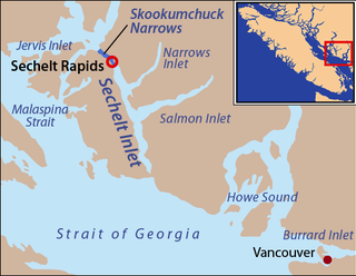
WSechelt Inlet formerly Seechelt Inlet is one of the principal inlets of the British Columbia Coast. The inlet is significant in that it almost makes an island of what is instead the Sechelt Peninsula, whose isthmus is at the town of Sechelt at the head of the inlet. The isthmus is less than 1.2 km (0.75 mi) in distance. Sechelt Inlet's mouth is at Jervis Inlet, inland from the Malaspina Strait.
 W
WSeton Lake is a freshwater fjord draining east via the Seton River into the Fraser River at the town of Lillooet, about 22 km (14 mi) long, 26.2 km2 (10.1 sq mi) in area and lies at an elevation of 243 m (797 ft). Its depth is 460 m (1,500 ft).
WSeymour Inlet is one of the lesser travelled of the principal inlets of the British Columbia Coast. Unlike larger inlets such as Knight or Bute, it is not flanked by mountains but by relatively low, but still rugged, coastal hill-country and forms a maze of complex, narrow waterways and tidal pools and lagoons. It is located within a corresponding maze of peninsulas on the mainland on the northwest side of the Queen Charlotte Strait region.
WSmith Inlet is an inlet at the head of Smith Sound on the Central Coast of British Columbia, Canada. Smith Inlet and Smith Sound are notable as the home of the Gwaʼsala group of the Kwakwakaʼwakw peoples, who are also known as the Smith Inlet people. Nekite Indian Reserve No. 2, which is under the governance of the Gwaʼsala-ʼNakwaxdaʼxw Nations band government, is located at the head of Smith Inlet, at the mouth of the Nekite River.
 W
WToba Inlet is one of the lesser, but still principal, inlets of the British Columbia Coast. It is fourth in the series north from the 49th parallel which begins with Burrard Inlet, which is the harbour for the city of Vancouver. Between it and Jervis Inlet to its east, however, there is a freshwater fjord, Powell Lake, which has been augmented by a small hydro project to supply power to the large pulp mill at Powell River, the principal town of the Malaspina Peninsula of the upper Sunshine Coast. Klahoose 1 Reserve, of the Klahoose First Nation is at the mouth of Toba River at the Head of Toba Inlet. Toba Inlet and the Toba Valley is home to many grizzly bears.