 W
WAlto de Nique is a mountain in South and Central America. It is 1,730 metres (5,676 ft) tall and sits on the international border between Colombia and Panama.
 W
WMount Alverstone or Boundary Peak 180, is a high peak in the Saint Elias Mountains, on the border between Alaska and Yukon. It shares a large massif with the higher Mount Hubbard to the south and the slightly lower Mount Kennedy to the east. The summit of Mount Alverstone marks a sharp turn in the Alaska/Canada border; the border goes south from this point toward the Alaska panhandle and west toward Mount Saint Elias.
 W
WMount Armour, also named Boundary Peak 175, is a mountain in Alaska and British Columbia, located on the Canada–United States border, and part of the Southern Icefield Ranges of the Saint Elias Mountains. It is named after John Douglas Armour (1830–1903), Chief Justice of the High Court of Ontario, and Justice of the Supreme Court of Canada, one of the original Canadian members of the Alaskan Boundary Tribunal in 1903 and who was involved in settling the Alaska boundary dispute between the United States and Canada.
 W
WMount Augusta, also designated Boundary Peak 183, is a high peak of the Saint Elias Mountains on the border between the U.S. state of Alaska and the Canadian territory of Yukon.
WMount Aylesworth, also named Boundary Peak 176, is a mountain in Alaska and British Columbia, located on the Canada–United States border, and part of the Southern Icefield Ranges of the Saint Elias Mountains. It is named after Sir Allen Bristol Aylesworth (1854–1952), Canadian constitutional lawyer and member of Alaskan Boundary Tribunal, and who was involved in settling the Alaska boundary dispute between the United States and Canada.
 W
WMount Barnard, also named Boundary Peak 160, is a mountain in Alaska and British Columbia, located on the Canada–United States border, and part of the Alsek Ranges of the Saint Elias Mountains. In 1923 Boundary Peak 160 was named Mount Barnard in honour of Edward Chester Barnard, a U.S. Boundary Commissioner from 1915 to 1921 and chief topographer of the United States and Canada Boundary Survey from 1903 to 1915. The first ascent of Mount Barnard was made on August 24, 1966 from the head of Tarr Inlet by D. Kenyon King, Peter H. Robinson and David P. Johnston. The details on file with Peak Service at Bartlett Cove, Glacier Bay National Monument, Gustavus, Alaska.
 W
WCaribou Mountain is a mountain on the Canada–United States border, the section of which follows the height of land of the Saint Lawrence River watershed. The peak is located about 0.5 mi (0.80 km) inside Franklin County, Maine. The southwest end of Caribou's summit ridge is in Le Granit Regional County Municipality, Québec.
 W
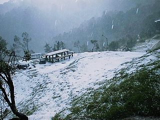
WCerro El Pital is a mountain in Central America, on the border of El Salvador and Honduras. It is located 12 km (7 mi) from the town of La Palma at a height of 2,730 m (8,957 ft) above sea level, and is the highest point in Salvadoran territory. Cerro El Pital is in the middle of a cloud forest that has an average annual temperature of 10 °C (50 °F).
 W
WVolcán Chingo is a stratovolcano on the border between Guatemala and El Salvador.
 W
WMount Cook is a high peak on the Yukon Territory-Alaska border, in the Saint Elias Mountains of North America. It is approximately 15 miles southwest of Mount Vancouver and 35 miles east-southeast of Mount Saint Elias. It forms one of the corners of the jagged border, which is defined to run in straight lines between the major peaks. The same border also separates Kluane National Park in the Yukon Territory from Wrangell-St. Elias National Park and Preserve in Alaska.
 W
WDevils Paw is the high point of the Juneau Icefield, on the Alaska-British Columbia border. It is a part of the Boundary Ranges of the Coast Mountains. It is notable for its steep rise above the low local terrain. Its height is sometimes given as 8,507 feet.
 W
WDevils Thumb, or Taalkhunaxhkʼu Shaa in Tlingit, is a mountain in the Stikine Icecap region of the Alaska–British Columbia border, near Petersburg. It is named for its projected thumb-like appearance. Its name in the Tlingit language means "the mountain that never flooded" and is said to have been a refuge for people during Aangalakhu. It is one of the peaks that marks the border, and is also listed on maps as Boundary Peak 71.
WMount Duff, also named Boundary Peak 174, is a mountain in Alaska and British Columbia, located on the Canada–United States border, and part of the Southern Icefield Ranges of the Saint Elias Mountains. It was named in 1923 for Sir Lyman Poore Duff, (1865-1948), a junior counsel before International Boundary Commission in 1903, and Judge of the Supreme Court of Canada.
WCerro Echandi is a mountain in Bocas del Toro Province of western Panama and in Limón of southwest Costa Rica, on the border with Costa Rica. It is part of the Cordillera de Talamanca, and reaches an elevation of 3,163 metres (10,377 ft).
 W
WMount Fairweather, is the highest mountain in the Canadian province of British Columbia, with an elevation of 4,671 metres (15,325 ft). It is located 20 km (12 mi) east of the Pacific Ocean on the border of Alaska, United States and western British Columbia, Canada. Most of the mountain lies within Glacier Bay National Park and Preserve in the City and Borough of Yakutat, Alaska (USA), though the summit borders Tatshenshini-Alsek Provincial Park, British Columbia (Canada). It is also designated as Boundary Peak 164 or as US/Canada Boundary Point #164.
 W
WMount Gallatin, also known as Boundary Peak 67, is a mountain in the Boundary Ranges along the British Columbia-Alaska border.
WMount Harris, also named Boundary Peak 156, is a mountain in Alaska and British Columbia, located on the Canada–United States border in the Takhinsha Mountains. In 1923 Boundary Peak 156 was named Mount Harris in honour of D. R. Harris, a surveyor in the Canadian section of the Boundary Survey.
WMount Hay, also named Boundary Peak 167, is a mountain in Alaska and British Columbia, located on the Canada–United States border, and part of the Fairweather Range of the Saint Elias Mountains. It was named in 1923 for John Milton Hay (1838-1905), author and diplomat. In 1903, John Hay helped negotiate the treaty resulting in Alaska Boundary Tribunal.
WMount Herbert, also named Boundary Peak 172, is a mountain in Alaska and British Columbia, located on the Canada–United States border, and part of the Southern Icefield Ranges of the Saint Elias Mountains. It was named in 1923 for Right Honorable Sir Michael Henry Herbert (1857-1903), British Ambassador to the United States during the early stages of Alaska Boundary Tribunal.
 W
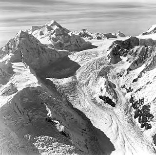
WMount Hubbard is one of the major mountains of the Saint Elias Range. It is located on the Alaska/Yukon border; the Canadian side is within Kluane National Park and Reserve, and the American side is part of Wrangell–St. Elias National Park. The mountain was named in 1890 by U.S. Geological Survey geologist Israel Russell after Gardiner Greene Hubbard, first president of the National Geographic Society, which had co-sponsored Russell's expedition.
WMount Jetté, also named Boundary Peak 177, is a mountain in Alaska and British Columbia, located on the Canada–United States border, and part of the Southern Icefield Ranges of the Saint Elias Mountains. It is named in 1908 for Sir Louis-Amable Jetté, (1836-1920), a member of the 1903 Canadian Boundary Tribunal, leading to the resolution of the Alaska Boundary Dispute, and Lieutenant Governor of the Province of Quebec from 1898 to 1908.
WMount Lodge, also named Boundary Peak 166, is a mountain in Alaska and British Columbia, located on the Canada–United States border, and part of the Fairweather Range of the Saint Elias Mountains. It was named in 1908 for Senator Henry Cabot Lodge, (1850-1924), U.S. Boundary Commissioner in 1903.
WMount London, also known as Boundary Peak 100, 2,326 m (7,631 ft), is a mountain on the Alaska-British Columbia boundary in the Juneau Icefield of the Boundary Ranges of the Coast Mountains, located southwest of Atlin, British Columbia on the border with Haines Borough Alaska. Originally called Mount Atlin, it was renamed in honour of the famous author Jack London (1876–1916).
 W
WMogotón is a mountain in the Reserva Nacional Cordillera Dipilto y Jalapa on the border of Nicaragua and Honduras. It rises 6,841 feet (2,085 m) above sea level and is the highest point in Nicaragua.
WMount Nesselrode, also known as Boundary Peak 98, 2,474 metres (8,117 ft) prominence: 924 m (3,031 ft), is a peak in the Boundary Ranges of the Coast Mountains, located on and in part defining the border between British Columbia, Canada and Alaska, United States. About 40 miles (64 km) north of Juneau to the west of the lower Stikine River and in the heart of the Stikine Icecap in Juneau Icefield southwest of Atlin Lake, it is also the corner point of Alaska's Haines Borough and Juneau Borough.
 W
WMount Quincy Adams is a mountain located on the border between United States and Canada. It is named after John Quincy Adams (1767–1848), the sixth president of the United States.
WMount Root, also named Boundary Peak 165, is a mountain in Alaska and British Columbia, located on the Canada–United States border, and part of the Fairweather Range of the Saint Elias Mountains. It is named for Elihu Root, who was one of the diplomats involved in settling the Alaska boundary dispute between the United States and Canada. It is where the Margerie Glacier is located.
 W
WMount Saint Elias, also designated Boundary Peak 186, is the second highest mountain in both Canada and the United States, being situated on the Yukon and Alaska border. It lies about 26 miles (42 km) southwest of Mount Logan, the highest mountain in Canada. The Canadian side is part of Kluane National Park and Reserve, while the U.S. side of the mountain is located within Wrangell-St. Elias National Park and Preserve.
 W
WSandy Bay Mountain, known officially in Quebec as Mont Sandy Stream, is a mountain located on the Canada–United States border, with a height of 950 m (3,117 ft) above sea level. The northeastern part of the mountain is in Somerset County, Maine, while the southwestern part is in Saint-Ludger, Quebec. There, it is unofficially known as Mont Bélanger.
 W
WMount Vancouver is the 15th highest mountain in North America. Its southern side lies in Glacier Bay National Park and Preserve at the top of the Alaska panhandle, while its northern side is in Kluane National Park and Reserve in the southwestern corner of Yukon, Canada. Mount Vancouver has three summits: north, middle, and south, with the middle summit being the lowest. The south summit, Good Neighbor Peak at 4,785 m (15,699 ft), straddles the international border while the north summit is slightly higher at 4,812 m (15,787 ft).
 W
WThe volcano Tacaná is the second highest peak in Central America at 4,060 metres (13,320 ft), located in the Sierra Madre de Chiapas of northern Guatemala and southern Mexico. It is also known in Mexico as Volcán Tacina.