 W
WThe following is a list of ecoregions in Canada as identified by the World Wide Fund for Nature (WWF).
 W
WThe Allegheny Highlands forests are a temperate broadleaf and mixed forests ecoregion of North America, as defined by the World Wildlife Fund.
 W
WThe Baffin coastal tundra is a small ecoregion of the far north of North America, on the central north coast of Baffin Island in the Canadian territory of Nunavut. This is permafrost tundra with an average annual temperature below freezing.
 W
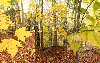
WA beech–maple forest or a maple beech forest is a climax mesic closed canopy hardwood forest. It is primarily composed of American beech and sugar maple trees which co-dominate the forest and which are the pinnacle of plant succession in their range. A form of this forest was the most common forest type in the Northeastern United States when it was settled by Europeans and remains widespread but scattered today.
 W
WThe concept of Cascadian bioregionalism is closely identified with the environmental movement. In the early 1970s, the contemporary vision of bioregionalism began to be formed through collaboration between natural scientists, social and environmental activists, artists and writers, community leaders, and back-to-the-landers who worked directly with natural resources. A bioregion is defined in terms of the unique overall pattern of natural characteristics that are found in a specific place. The main features are generally obvious throughout a continuous geographic terrain and include a particular climate, local aspects of seasons, landforms, watersheds, soils, and native plants and animals. People are also counted as an integral aspect of a locale's life, as can be seen in the ecologically adaptive cultures of early inhabitants, and in the activities of present-day reinhabitants who attempt to harmonize in a sustainable way with the place where they live.
 W
WThe Central Canadian Shield forests are a taiga ecoregion of Eastern Canada, as defined by the World Wildlife Fund (WWF) categorization system.
 W
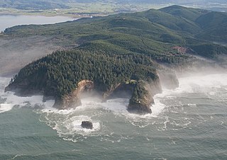
WThe Central Pacific coastal forests is a temperate coniferous forest ecoregion located in the Canadian province of British Columbia and the U.S. states of Oregon and Washington, as defined by the World Wildlife Fund (WWF) categorization system.
 W
WThe Davis Highlands tundra ecoregion covers the Baffin Mountains on the northeast coast of Baffin Island and Bylot Island, facing Baffin Bay in Nunavut, northern Canada. The terrain is extremely rugged, heavily glaciated, with many deep fjords, and very cold. About half of the territory is moss and lichen tundra, the other half bare rock and ice. The region is wetter than the much drier regions to the southwest of the Baffin Islands.
 W
WThe Eastern Canadian forests is a taiga ecoregion in Eastern Canada, as defined by the World Wildlife Fund (WWF) categorization system.
 W
WThe Eastern Canadian Shield taiga is an ecoregion of Canada as defined by the World Wildlife Fund (WWF) categorization system.
 W
WThe Eastern Great Lakes lowland forests is a temperate broadleaf and mixed forest ecoregion of North America, as defined by the World Wildlife Fund. It lies mostly in south and eastern Ontario and Quebec in Canada, and Upstate New York in the United States.
 W
WThe Gulf of St. Lawrence lowland forests are a temperate broadleaf and mixed forest ecoregion of Eastern Canada, as defined by the World Wildlife Fund (WWF) categorization system.
 W
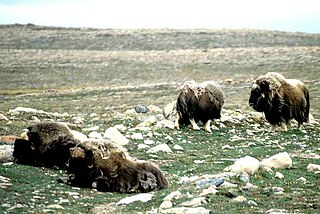
WThe High Arctic tundra ecoregion covers most of Canada's northern Arctic Archipelago - from the Queen Elizabeth Islands nearest to Greenland in the northeast, and down through the center of Baffin Island. Much of the northern islands are covered in ice, and the climate is very dry with as little as 50 mm/year in places. The ecoregion has very little human habitation, and most of the non-ice terrain is moss and lichen cover. The region supports viable populations of arctic mammals such as muskox, arctic wolves, arctic foxes, arctic hares, polar bears, and caribou.
 W
WThe Hudson Plains Ecoregion is a vast, flat, and waterlogged landscape. This ecoregion covers a 369,000 square kilometer area along the south shoreline of the Hudson Bay, which includes the Canadian provinces of Eastern Quebec, Northern Ontario and Western Manitoba. Because of the location of the ecoregion, winter prevails for many months of the year and rising temperatures, along with melting ice, makes fog common. The short summers provide a home for thousands of migrating birds. The region is used by humans for its mineral resources and hydroelectric power as a result of the abundance of water and emergent societal needs. Though relatively uninhabited and undisturbed, the natural resources of the Hudson Plains are still subject to anthropogenic activities. Its climatic, geographic, and evolutionary patterns categorize it as one of many ecoregions in North America.
 W
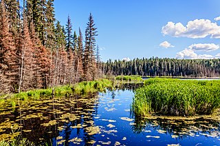
WThe Interior Yukon-Alaska alpine tundra ecoregion covers alpine, sub-alpine, and boreal forest areas along the cordillera of Interior Alaska and south-central Yukon Territory. Geologically, they are the disjunct uplands of the Yukon-Tanana Terrane plus a southern extension of the Brooks Range. The cover is extensive 'dark taiga' of closed spruce forest, open forest of other species, and alpine vegetation at higher altitudes. The region is mostly wilderness and relatively untouched by human development.
 W
WThe Laurentian Mixed Forest Province, also known as the North Woods, is a forested ecoregion in eastern North America. Among others, this terminology has been adopted by the Minnesota Department of Natural Resources. Similar, though not necessarily entirely identical regions, are identified by the United States Environmental Protection Agency as Northern Lakes and Forests, and by the World Wildlife Fund by regions such as the Western Great Lakes forests and Eastern forest-boreal transition.
 W
WThe Low Arctic tundra ecoregion covers a rolling landscape of shrubby tundra vegetation along the northern edge of mainland Canada along the border of the Northwest Territories and Nunavut, and a small portion in Quebec on the northeast coast of Hudson Bay. The region is important for large herds of caribou and other large mammals, and for large nesting colonies of birds such as snow geese. The region is mostly intact, with 95% remaining intact.
 W
WThe Mid-Continental Canadian forests are a taiga ecoregion of Western Canada, as defined by the World Wildlife Fund (WWF) categorization system.
 W
WThe Middle Arctic tundra ecoregion covers a broad stretch of northern Canada - the southern islands of the Arctic Archipelago, plus the northern mainland of Nunavut and, across Hudson Bay to the east, a portion of northern Quebec. This is the coldest and driest ecoregion in Canada, and can be referred to as a 'polar desert'. It is an important region for breeding and migratory bird, and supports 80% of the world's muskox.
 W
WThe Midwestern Canadian Shield forests ecoregion, in the Taiga and Boreal forests Biome, are of northern Canada.
 W
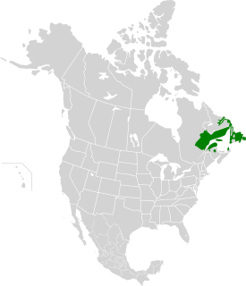
WThe Newfoundland Highland forests are a taiga ecoregion located on the island of Newfoundland in Newfoundland and Labrador, Canada. It has a total area of 4,031,999 acres.
 W
WNorthern Canadian Shield taiga is a taiga ecoregion located in Canada, as defined by the World Wildlife Fund (WWF) categorization system.
 W
WThe northern hardwood forest is a general type of North American forest ecosystem found over much of southeastern and south central Canada, Ontario and Quebec, extending south into the United States in northern New England, New York, and Pennsylvania, and west along the Great Lakes to Minnesota and western Ontario. Some ecologists consider it a transitional forest because it contains species common to both the oak-hickory forest community to the south and the Boreal forest community to the north. The trees and shrub species of the Northern Hardwood Forest are known for their brilliant fall colors, making the regions that contain this forest type popular fall foliage tourist destinations.
 W
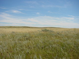
WThe Northern short grasslands includes parts of the Canadian provinces of Alberta and Saskatchewan, and the American Great Plains states of Montana, North Dakota, Wyoming, South Dakota and Nebraska. One of 867 terrestrial ecoregions defined by the World Wide Fund for Nature, the United States Environmental Protection Agency (EPA) further breaks this ecoregion into the Northwestern Glaciated Plains and Northwestern Great Plains.
 W
WThe Ogilvie-MacKenzie alpine tundra ecoregion covers the mountainous middle of the Yukon Territory in Canada, with extensions into the Northwest Territories. The vegetation is alpine and subalpine open forest of stunted spruce, fir and pine. The area is rugged but sections appear to have been unglaciated in the late Pleistocene and there are therefore relic species in the region. The area is remote and supports large, sustainable predator-prey systems.
 W
WThe Pacific temperate rainforests ecoregion of North America is the largest temperate rain forest ecoregion on the planet as defined by the World Wildlife Fund. The Pacific temperate rain forests lie along the western side of the Pacific Coast Ranges along the Pacific Northwest Coast of North America from the Prince William Sound in Alaska through the British Columbia Coast to Northern California, and are part of the Nearctic realm, as also defined by the World Wildlife Fund. The Pacific temperate rain forests are characterized by a high amount of rainfall, in some areas more than 300 cm (10 ft) per year and moderate temperatures in both the summer and winter months.
 W
WRock Glen Conservation Area is a suburban conservation area located in the town of Arkona, in the municipality of Lambton Shores, Ontario, Canada. The conservation area is owned and maintained by the Ausable Bayfield Conservation Authority (ABCA). The former "Ausable River Conservation Authority" was Ontario's first conservation authority, created in 1946. The Bayfield River watershed and smaller streams were added in 1971. Local municipalities and the Province of Ontario formed "Ausable Bayfield Conservation Authority" (ABCA) to prevent the loss of important local ecosystems, to protect life and property through flood management, and to build a healthier natural environment on a watershed scale. Rock Glen Conservation Area is situated in a transition zone between the Carolinian forest zone to the south, and the Great Lakes, in Lambton Shores, Ontario, Canada. On the conservation area grounds is the Arkona Lions Museum and Information Centre; which houses a collection of Devonian period fossils and Aboriginal artifacts found in the local area.
 W
WThe Southern Hudson Bay taiga is a terrestrial ecoregion, as classified by the World Wildlife Fund, which extends along the southern coast of Hudson Bay and resides within the larger taiga biome. Entirely located in Canada, it covers an area of approximately 373,735 km2 and crosses the provinces of Manitoba, Ontario, and the western portion of Quebec. Various islands in James Bay which belong to the Northwest Territories are also considered to be part of the ecoregion.
 W
WThe Tallgrass Aspen Parkland is an ecoregion located in southeastern Manitoba and northwestern Minnesota. The area is characterized by a mosaic of habitat types, including tallgrass prairie, aspen woodland, sedge meadow wetlands, riparian woodland, and oak savanna. A number of endangered and threatened species occur in the area, including the western prairie fringed orchid and Dakota skipper. One of Minnesota's only wild elk herds utilizes the area as well.
 W
WThe tallgrass prairie is an ecosystem native to central North America. Natural and anthropogenic fire, as well as grazing by large mammals, were historically agents of periodic disturbance, which regulates tree encroachment, recycles nutrients to the soil, and catalyzes some seed dispersal and germination processes. Prior to widespread use of the steel plow, which enabled large scale conversion to agricultural land use, tallgrass prairies extended throughout the American Midwest and smaller portions of southern central Canada, from the transitional ecotones out of eastern North American forests, west to a climatic threshold based on precipitation and soils, to the southern reaches of the Flint Hills in Oklahoma, to a transition into forest in Manitoba.
 W
WThe Torngat Mountain tundra ecoregion covers the Torngat Mountains on the northeastern tip of the Labrador Peninsula where the provinces of Quebec and Newfoundland and Labrador meet. The mountains feature glacially carved U-shaped valleys and deep fjords. The vegetation over most of the territory is that of arctic tundra, herbaceous cover, or bare rock. The region supports seasonal polar bears, black bears, and caribou. The Atlantic coast is on the Atlantic Flyway for migratory birds.
 W
WThe Western Great Lakes forests is a terrestrial ecoregion as defined by the World Wildlife Fund. It is within the temperate broadleaf and mixed forests biome of North America, in northern areas of the United States' states of Michigan, Wisconsin and Minnesota, and southern areas of the Canadian provinces of Ontario and Manitoba.