 W
WThe North York Moors is an upland area in North Yorkshire, England, containing one of the largest expanses of heather moorland in the United Kingdom. The North York Moors National Park was designated in 1952, through the National Parks and Access to the Countryside Act 1949. The National Park covers an area of 554 sq mi (1,430 km2), and has a population of 23,380. It is administered by the North York Moors National Park Authority, whose head office is based in Helmsley.
 W
WBeast Cliff is a steep sea cliff situated about halfway between Whitby and Scarborough on the coast of North Yorkshire in northeastern England. Beast Cliff is at the southern end of a coastal region designated as a Special Area of Conservation and Site of Special Scientific Interest. Bordering the eastern edge of the North York Moors national park, the Cleveland Way runs at the head of the cliffs.
 W
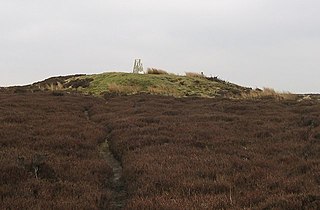
WBlakey Topping standing stones is a small group of standing stones near the Hole of Horcum in the North York Moors. It sits at the foot of Blakey Topping hill.
 W
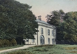
WBusby Hall is a Grade II* listed Country House in Little Busby, North Yorkshire, England, close to the village of Carlton-in-Cleveland. The house and parkland sits within the North York Moors National Park.
 W
WCarlton Bank is a hill in the Cleveland Hills, in north-east England. It is located on Carlton Moor in the North York Moors and overlooks the villages of Carlton-in-Cleveland and Faceby. The summit provides extensive views of Teesside including Middlesbrough and Redcar to the north as well as the surrounding moorland. Roseberry Topping can also be clearly seen from the summit in a north-easterly direction. The Cleveland Way National Trail crosses Carlton Bank and is part of Wainwright's Coast to Coast Walk.
 W
WThe Cleveland Hills are a range of hills on the north-west edge of the North York Moors in North Yorkshire, England, overlooking Cleveland and Teesside. They lie entirely within the boundaries of the North York Moors National Park. Part of the 110-mile (177 km) long Cleveland Way National Trail runs along the hills, and they are also crossed by a section of Wainwright's Coast to Coast Walk. The hills, which rise abruptly from the flat Tees Valley to the north, include distinctive landmarks such as the cone-shaped peak of Roseberry Topping, near the village of Great Ayton – childhood home of Captain James Cook.
 W
WThe Cleveland Way is a National Trail in ancient Cleveland in northern England. It runs 110 miles (177 km) between Helmsley and the Brigg at Filey, skirting the North York Moors National Park.
 W
WCringle Moor, at 432 m (1,417 ft), is the third highest hill in the North York Moors, England, and the highest point west of Clay Bank.
 W
WDalby Forest is a forest located on the southern slopes of the North York Moors National Park in North Yorkshire, England. It is maintained by the UK Forestry Commission. Dalby Forest, along with Langdale Forest and Cropton Forest, forms part of the North Riding Forest Park, found within the North York Moors National Park.
 W
WEasby Moor is a hill located in the North York Moors national park within the Cleveland Hills, North Yorkshire, England. At the peak, at 324 metres (1,063 ft) above sea level, is a monument to Captain James Cook, who was native to the area. The Cleveland Way runs over the moor. The moor overlooks the villages of Easby and Great Ayton.
 W
WFrank Watson Elgee was a published archaeologist, geologist and naturalist who wrote several books on the North York Moors such as The Moorlands of North-Eastern Yorkshire (1912), The Romans in Cleveland (1923) and Early Man in North East Yorkshire (1930). In 1933 Leeds University conferred on him an Honorary degree of Doctor of Philosophy.
 W
WThe Esk Valley Walk is a long distance footpath in North Yorkshire, England. The route first follows a loop on the North York Moors to the south of Castleton, then shadows the River Esk on its journey to the North Sea. Waymarking uses the symbol of a leaping salmon, with yellow arrows denoting footpaths and blue arrows bridleways.
 W
WFarndale is a valley and civil parish in Ryedale district, North Yorkshire, England, which is known for the daffodils which flower each spring along a 7-mile (11 km) stretch of the River Dove. The valley is in the North York Moors National Park, some 11 miles (18 km) north of Kirkbymoorside, the nearest town. Pickering is some 17 miles (27 km) to the south-east and Helmsley 17 miles (27 km) to the south-west.
 W
WGisborough Moor is a moor in England's North York Moors, lying to the south of the town of Guisborough. The summit is a broad flat ridge, with the highest point at the southern end, some 1-mile (1.5 km) south of a trig point. It is crossed by a number of footpaths leading between the Cleveland Way and Commondale and other settlements to the south. Highcliff Nab, near the moor's north-western corner, overlooks Guisborough from the edge of the scarp.
 W
WThe Hambleton Hills are a range of hills in North Yorkshire, England. They form the western edge of the North York Moors but are separated from the moors by the valley of the River Rye. They are the eastern boundary of the low-lying Vale of Mowbray which they abut with a precipitous escarpment.
 W
WHasty Bank is a hill in the Cleveland Hills range of the North York Moors, in north-east England. The Cleveland Way National Trail crosses Hasty Bank and is part of Wainwright's Coast to Coast Walk. The north face of Hasty Bank has heavily eroded, possessing a vertical rocky face sloping steeply down to Broughton Bank. Roseberry Topping can be clearly seen from the summit which offers great views of the Tees Valley.
WThe Lyke Wake Walk is a 40-mile (64 km) challenge walk across the highest and widest part of the North York Moors National Park in North Yorkshire, England. Its associated club has a social structure, culture and rituals based on the walk and Christian and folklore traditions from the area through which it passes.
 W
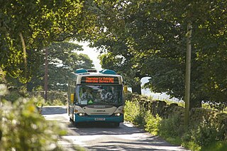
WMoorsbus is a network of bus services operating to and around the North York Moors National Park and surrounding areas. It was operated from the 1980s by the North York Moors National Park Authority, and linked places such as Malton, Teesside, Thirsk, York and Hull to the National Park.
 W
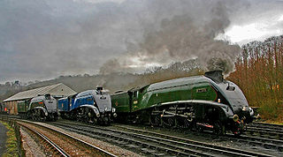
WThe North Yorkshire Moors Railway (NYMR) is a heritage railway in North Yorkshire, England, that runs through the North York Moors National Park. First opened in 1836 as the Whitby and Pickering Railway, the railway was planned in 1831 by George Stephenson as a means of opening up trade routes inland from the then important seaport of Whitby. The line between Grosmont and Rillington was closed in 1965 and the section between Grosmont and Pickering was reopened in 1973 by the North York Moors Historical Railway Trust Ltd. The preserved line is now a tourist attraction and has been awarded several industry accolades.
 W
WRoyal Air Force Fylingdales or more simply RAF Fylingdales is a Royal Air Force station on Snod Hill in the North York Moors, England. Its motto is "Vigilamus". It is a radar base and is also part of the Ballistic Missile Early Warning System (BMEWS). As part of intelligence-sharing arrangements between the United States and United Kingdom, data collected at RAF Fylingdales are shared between the two countries. Its primary purpose is to give the British and US governments warning of an impending ballistic missile attack. A secondary role is the detection and tracking of orbiting objects; Fylingdales is part of the United States Space Surveillance Network. As well as its early-warning and space-tracking roles, Fylingdales has a third function - the Satellite Warning Service for the UK. It keeps track of spy satellites used by other countries, so that secret activities in the UK can be carried out when they are not overhead. The armed services, defence manufacturers and research organisations, including universities, take advantage of this facility.
 W
WRoseberry Topping is a distinctive hill in North Yorkshire, England. It is situated near Great Ayton and Newton under Roseberry. Its summit has a distinctive half-cone shape with a jagged cliff, which has led to many comparisons with the much higher Matterhorn in the Swiss-Italian Alps. It forms a symbolic image of the area and features in the logo for the nearby Teesside International Airport.
 W
WScaling Dam Reservoir is a freshwater man-made lake on the edge of the A171 road in North Yorkshire, England. The reservoir is near to the hamlet of Scaling Dam from where it derives its name, and was built in 1958.
 W
WThe Scarborough and Ryedale Mountain Rescue Team provides Search and Rescue services in and around the Scarborough and Ryedale areas of North Yorkshire, England. The team has no formal southern boundary and has carried out searches in the urban fringe areas of the East Riding of Yorkshire
 W
WThe Secret Garden is a 2020 British fantasy drama film based on the 1911 novel of the same name by Frances Hodgson Burnett, the fourth film adaptation of the novel. Directed by Marc Munden and produced by David Heyman, it stars Dixie Egerickx, Colin Firth, and Julie Walters. Set in 1947 England, the plot follows a young orphan who is sent to live with her uncle, only to discover a magical garden at his estate.
 W
WSheepwash is a popular tourist spot in the North York Moors, North Yorkshire, England. It is located on Cod Beck which flows into Cod Beck Reservoir near Osmotherley.
 W
WSutton Bank is a hill in the Hambleton District of the North York Moors National Park, North Yorkshire in England. It is a high point on the Hambleton Hills with extensive views over the Vale of York and the Vale of Mowbray.
 W
WThe Tabular Hills are an east-west line of distinct hills on the southern boundary of the North York Moors, running from Scarborough in the east to Black Hambleton in the west. The name refers to their flat, tabular summits composed of hard Corallian limestone known locally as "nabs". They form the northern boundary of the Vale of Pickering.
 W
WUrra Moor is the highest moor in the North York Moors, North Yorkshire, England. At 1,490 feet (454 m) above sea level it is the highest point in Hambleton District and the North York Moors National Park, and the fourteenth most prominent hill in England. The name is a mix of Old English and Old Norse which means The Dirty Hill. The name of Urra Moor applies to the moor as a whole; the summit itself is known as Round Hill.
 W
WWade's Causeway is a sinuous, linear monument up to 6,000 years old in the North York Moors national park in North Yorkshire, England. The name may refer to either scheduled ancient monument number 1004876—a length of stone course just over 1 mile (1.6 km) long on Wheeldale Moor, or to a postulated extension of this structure, incorporating ancient monuments numbers 1004108 and 1004104 extending to the north and south for up to 25 miles (40 km). The visible course on Wheeldale Moor consists of an embankment of soil, peat, gravel and loose pebbles 0.7 metres (2.3 ft) in height and 4 to 7 metres in width. The gently cambered embankment is capped with unmortared and loosely abutted flagstones. Its original form is uncertain since it has been subjected to weathering and human damage.
 W
WThe Whitby and Pickering Railway (W&P) was built to halt the gradual decline of the port of Whitby on the east coast of England. Its basic industries—whaling and shipbuilding—had been in decline and it was believed that opening transport links inland would help regenerate the town and port.
 W
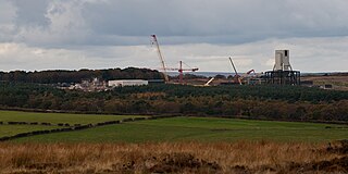
WWoodsmith Mine is a deep potash and polyhalite mine located near to the hamlet of Sneatonthorpe, Whitby in North Yorkshire, England. The venture was started by York Potash Ltd, which became a subsidiary of Sirius Minerals plc whose primary focus is the development of the polyhalite project. The project will mine the world's largest deposit of polyhalite – a naturally occurring mineral. Because the project would require mining to be undertaken in the North York Moors National Park, many objections were raised to the mine and the proposed conveyor that would be installed to transport the raw material offsite to a plant on Teesside 23 miles (37 km) away.
 W
WThe Woodsmith Mine Tunnel is a 23-mile (37 km) long tunnel that will stretch between Woodsmith Mine at Sneatonthorpe near Whitby in North Yorkshire and the Wilton International complex on Teesside, England. The tunnel has been in development since 2016, but cutting of the tunnel bore did not start until April 2019, with an expected finish date of 2021. By the end of July 2020, over 4 miles (6.4 km) of tunnel had been dug out.