 W
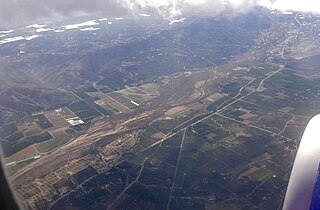
WThe Santa Clara River is 83 miles (134 km) long, and is one of the most dynamic river systems in Southern California. The river drains parts of four ranges in the Transverse Ranges System north and northwest of Los Angeles, then flows west onto the Oxnard Plain and into the Santa Barbara Channel of the Pacific Ocean.
 W
WBardsdale is a rural unincorporated community and populated place in Ventura County, California. It is located in the orange blossom and agricultural belt of the Santa Clara River Valley, south of the Santa Clara River and on the north slope of South Mountain. The closest town is Fillmore, which is on the north side of the Santa Clara about 3 miles (5 km) from Bardsdale. Santa Paula is about 7 miles (11 km) west, the most direct route being South Mountain Road. Moorpark is about 6 miles (10 km) south over the serpentine mountain road known as Grimes Canyon.
 W
WBouquet Reservoir is an artificial lake in the Angeles National Forest of Los Angeles County, California about 15 miles (24 km) west from Palmdale.
 W
WState Route 126 is a state highway in the U.S. state of California that serves Ventura and Los Angeles counties. The route runs from U.S. Route 101 in Ventura to Interstate 5 in Santa Clarita through the Santa Clara River Valley. The highway is an important connector highway in Ventura County, and serves as an alternate route into the Santa Clarita Valley, and the San Fernando Valley area of Los Angeles and the High Desert of Antelope Valley.
 W
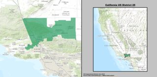
WCalifornia's 25th congressional district is a congressional district in the U.S. state of California that currently covers most of northern Los Angeles County and part of eastern Ventura County. It includes the cities of Palmdale and Santa Clarita, most of Lancaster and Simi Valley, and the northern part of San Fernando Valley.
 W
WCalifornia 26th congressional district is a congressional district in the U.S. state of California currently represented by Democrat Julia Brownley.
 W
WCastaic Creek is a 25.0-mile-long (40.2 km) stream in the Sierra Pelona Mountains, in northeastern Los Angeles County, California. It is a tributary of the Santa Clara River.
 W
WCastaic Junction is an unincorporated community located in Los Angeles County, California. It is located at the crossroads of Interstate 5 and State Route 126 at the Santa Clara River.
 W
WElizabeth Lake is a natural lake that lies directly on the San Andreas Fault in the northern Sierra Pelona Mountains, in northwestern Los Angeles County, southern California.
 W
WFillmore is a small city in Ventura County, California, United States, in the Santa Clara River Valley. In an agricultural area with rich, fertile soil, Fillmore has a historic downtown that was established when the Southern Pacific built the railroad through the valley in 1887. The rail line also provided a name for the town: J. A. Fillmore was a general superintendent for the company's Pacific system. The population was 15,002 at the 2010 census, up from 13,643 at the 2000 census.
 W
WHughes Lake, referred to before 1924 as West Elizabeth Lake, is a lake on the San Andreas Fault in the northern Sierra Pelona Mountains, in Los Angeles County, California.
 W
WLake Piru is a reservoir located in Los Padres National Forest and Topatopa Mountains of Ventura County, California, created by the construction in 1955 of the Santa Felicia Dam on Piru Creek, which is a tributary of the Santa Clara River.
 W
WMcGrath State Beach is a protected beach park located on the south bank of the mouth of Santa Clara River in the city of Oxnard, California. McGrath State Beach is one of the best bird-watching areas in California, with the lush riverbanks of the Santa Clara River and sand dunes along the shore. A nature trail leads to the Santa Clara Estuary Natural Preserve. Camping sites are available. Two miles of beach provide surfing and fishing opportunities. Just south of the station is the undeveloped Mandalay Beach Park which is about a mile downcoast beach walk from the park or a bike ride along Harbor Blvd. Located south of Ventura on Harbor Boulevard, the beach is on the Pacific Coast Bicycle Route and the California Coastal Trail.
WMunz Lakes is a small lake located directly on the San Andreas Fault in the northern Sierra Pelona Mountains, within Los Angeles County, California.
 W
WThe Oxnard Plain is a large coastal plain in southwest Ventura County, California, United States surrounded by the mountains of the Transverse ranges. The cities of Oxnard, Camarillo, Port Hueneme and much of Ventura as well as the unincorporated communities of Hollywood Beach, El Rio, Saticoy, Silver Strand Beach, and Somis lie within the over 200-square-mile alluvial plain (520 km2). The population within the plain comprises a majority of the western half of the Oxnard-Thousand Oaks-Ventura Metro Area and includes the largest city along the Central Coast of California. The 16.5-mile-long coastline (26.6 km) is among the longest stretches of continuous, linear beaches in the state.
 W
WOxnard is a city in Ventura County, California, United States. On California's South Coast, it is the most populous city in Ventura County and the 22nd most populous city in California. Incorporated in 1903, Oxnard lies approximately 60 miles (97 km) west of downtown Los Angeles and is part of the larger Greater Los Angeles area.
 W
WPiru Creek is a major stream, about 71 miles (114 km) long, in northern Los Angeles County and eastern Ventura County, California. It is a tributary of the Santa Clara River, the largest stream system in Southern California that is still relatively natural.
 W
WRancho Camulos, now known as Rancho Camulos Museum, is a ranch located in the Santa Clara River Valley 2.2 miles (3.5 km) east of Piru, California and just north of the Santa Clara River, in Ventura County, California. It was the home of Ygnacio del Valle, a Californio alcalde of the Pueblo de Los Angeles in the 19th century and later elected member of the California State Assembly. The ranch was known as the Home of Ramona because it was widely believed to have been the setting of the popular 1884 novel Ramona by Helen Hunt Jackson. The novel helped to raise awareness about the Californio lifestyle and romanticized "the mission and rancho era of California history."
 W
WRancho El Rio de Santa Clara o la Colonia was a 44,883-acre (181.64 km2) Mexican land grant in present-day Ventura County, California given in 1837 by Governor Juan B. Alvarado to Valentine Cota et al. The grant extended from the Santa Clara River south to the present-day Point Mugu Naval Air Station, and the boundary of Rancho Guadalasca, and east from the Pacific Ocean to the present-day 101 Freeway, and the boundary of Rancho Santa Clara del Norte. The grant encompassed present-day Colonia and Oxnard.
 W
WRancho San Francisco was a land grant in present-day northwestern Los Angeles County and eastern Ventura County, California. It was a grant of 48,612 acres (19,673 ha) by Governor Juan B. Alvarado to Antonio del Valle, a Mexican army officer, in recognition for his service to Alta California. It is not related to the city of San Francisco.
 W
WThe St. Francis Dam was a curved concrete gravity dam, built to create a large regulating and storage reservoir for the city of Los Angeles, California. The reservoir was an integral part of the city's Los Angeles Aqueduct water supply infrastructure. It was located in San Francisquito Canyon of the Sierra Pelona Mountains, about 40 miles (64 km) northwest of downtown Los Angeles, and approximately 10 miles (16 km) north of the present day city of Santa Clarita.
 W
WSan Francisquito Creek, in Los Angeles County, is a tributary stream of the Santa Clara River. It drains the south facing slopes of the Sierra Pelona Mountains of the San Gabriel Mountains within the Transverse Range of California, United States.
 W
WSand Canyon is a valley in northwestern Los Angeles County, California.
WState Route 126 is a state highway in the U.S. state of California that serves Ventura and Los Angeles counties. The route runs from U.S. Route 101 in Ventura to Interstate 5 in Santa Clarita through the Santa Clara River Valley. The highway is an important connector highway in Ventura County, and serves as an alternate route into the Santa Clarita Valley, and the San Fernando Valley area of Los Angeles and the High Desert of Antelope Valley.
 W
WThe Santa Clara River Valley is a rural, mainly agricultural, valley in Ventura County, California that has been given the moniker Heritage Valley by the namesake tourism bureau. The valley includes the communities of Santa Paula, Fillmore, Piru and the national historic landmark of Rancho Camulos. Named for the Santa Clara River, which winds through the valley before emptying into the Pacific Ocean between the cities of Ventura and Oxnard, the tourist bureau describes it as ".... Southern California's last pristine agricultural valley nestled along the banks of the free-flowing Santa Clara River."
 W
WThe Santa Clarita Valley (SCV) is part of the upper watershed of the Santa Clara River in Southern California. The valley was part of the 48,612-acre (19,673 ha) Rancho San Francisco Mexican land grant. Located in Los Angeles County, its main population center is the city of Santa Clarita which includes the communities of Canyon Country, Newhall, Saugus, and Valencia. Adjacent unincorporated communities include Castaic, Stevenson Ranch, Val Verde, and the new master planned community of Newhall Ranch.
WLake Piru is a reservoir located in Los Padres National Forest and Topatopa Mountains of Ventura County, California, created by the construction in 1955 of the Santa Felicia Dam on Piru Creek, which is a tributary of the Santa Clara River.
 W
WSanta Paula is a city in Ventura County, California, United States. Situated amid the orchards of the fertile Santa Clara River Valley, the city advertises itself to tourists as the "Citrus Capital of the World". Santa Paula was one of the early centers of California's petroleum industry. The Union Oil Company Building, the founding headquarters of the Union Oil Company of California in 1890, now houses the California Oil Museum. The population was 29,321 at the 2010 census, up from 28,598 at the 2000 census.
 W
WSaticoy is an unincorporated community in Ventura County, California, United States. The name comes from the Chumash village named Sa'aqtik'oy. The settlement was laid out in 1887 along the railroad line that was being built from Los Angeles through the Santa Clara River Valley to the town of San Buenaventura. Although the town was 10 miles (16 km) distant at that time, the City of Ventura grew so the community is now just outside the city limits. For statistical purposes, the United States Census Bureau has defined Saticoy as a census-designated place (CDP). The census definition of the area does not precisely correspond to the local understanding of the historical area of the community.
 W
WSespe Creek is a stream, some 61 miles (98 km) long, in Ventura County, southern California, in the Western United States. The creek starts at Potrero Seco in the eastern Sierra Madre Mountains, and is formed by more than thirty tributary streams of the Sierra Madre and Topatopa Mountains, before it empties into the Santa Clara River in Fillmore.
 W
WSoledad Canyon is a long narrow canyon/valley located in Los Angeles County, California between the cities of Palmdale and Santa Clarita. It is a part of the Santa Clara River Valley, and extends from the top of Soledad Pass to the open plain of the Valley in Valencia. The upstream section of the Santa Clara River runs through it.
 W
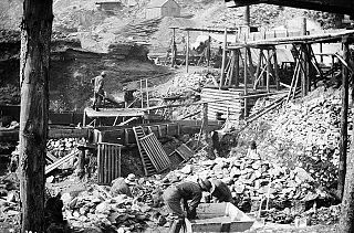
WThe Soledad Canyon Sand and Gravel Mining Project is the legal name of a mining project in Northern Los Angeles County east of the City of Santa Clarita, California, United States. First mined in 1921, the property was later mined by Curtis Sand and Gravel from the early 1960s until 1989, when, as a result of a legal settlement, the Bureau of Land Management put two 10-year leases to mine sand and gravel from the site out to competitive bid. The contracts were awarded to Transit Mixed Concrete, which eventually sold them to Cemex Corporation.