 W
WStratigraphy is a branch of geology concerned with the study of rock layers (strata) and layering (stratification). It is primarily used in the study of sedimentary and layered volcanic rocks. Stratigraphy has two related subfields: lithostratigraphy and biostratigraphy.
 W
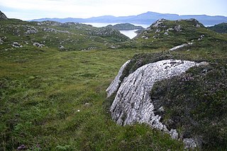
WIn geology and related fields, a stratum is a layer of sedimentary rock or soil, or igneous rock that was formed at the Earth's surface, with internally consistent characteristics that distinguish it from other layers. The "stratum" is the fundamental unit in a stratigraphic column and forms the basis of the study of stratigraphy. A stratum can be seen in almost every single country in the world.
 W
WThe 774–775 carbon-14 spike is an observed increase of 1.2% in the concentration of carbon-14 isotope in tree rings dated to 774 or 775, which is about 20 times as high as the normal background rate of variation. It was discovered during a study of Japanese cedar trees, with the year of occurrence determined through dendrochronology. A surge in beryllium isotope 10Be, detected in Antarctic ice cores, has also been associated with the 774–775 event. It is known as the Miyake event or the Charlemagne event and it produced the largest and most rapid rise in carbon-14 ever recorded.
 W
WIn geology, basement and crystalline basement are the rocks below a sedimentary platform or cover, or more generally any rock below sedimentary rocks or sedimentary basins that are metamorphic or igneous in origin. In the same way, the sediments or sedimentary rocks on top of the basement can be called a "cover" or "sedimentary cover".
 W
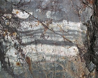
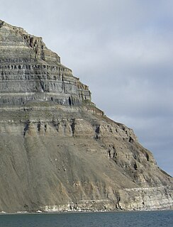
WBeds are the layers of sedimentary rocks that are distinctly different from overlying and underlying subsequent beds of different sedimentary rocks. Layers of beds are called strata. They are formed from sedimentary rocks being deposited on the Earth's solid surface over a long periods of time. The strata are layered in the same order that they were deposited, permitting discrimination as to which beds are younger and which ones are older. The structure of a bed is determined by its bedding plane. Beds can be differentiated in various ways, including rock or mineral type and particle size. The term is generally applied to sedimentary strata, but may also be used for volcanic flows or ash layers.
 W
WBiostratigraphy is the branch of stratigraphy which focuses on correlating and assigning relative ages of rock strata by using the fossil assemblages contained within them. The primary objective of biostratigraphy is correlation, demonstrating that a particular horizon in one geological section represents the same period of time as another horizon at a different section. Fossils within these strata are useful because sediments of the same age can look completely different, due to local variations in the sedimentary environment. For example, one section might have been made up of clays and marls, while another has more chalky limestones. However, if the fossil species recorded are similar, the two sediments are likely to have been laid down around the same time. Ideally these fossil are used to help identify biozones, as they make up the basic biostratigraphy units, and define geological time periods based upon the fossil species found within each section.
 W
WA core sample is a cylindrical section of (usually) a naturally-occurring substance. Most core samples are obtained by drilling with special drills into the substance, such as sediment or rock, with a hollow steel tube, called a core drill. The hole made for the core sample is called the "core hole". A variety of core samplers exist to sample different media under different conditions. More continue to be invented on a regular basis. In the coring process, the sample is pushed more or less intact into the tube. Removed from the tube in the laboratory, it is inspected and analyzed by different techniques and equipment depending on the type of data desired.
 W
WCross-cutting relationships is a principle of geology that states that the geologic feature which cuts another is the younger of the two features. It is a relative dating technique in geology. It was first developed by Danish geological pioneer Nicholas Steno in Dissertationis prodromus (1669) and later formulated by James Hutton in Theory of the Earth (1795) and embellished upon by Charles Lyell in Principles of Geology (1830).
 W
WCyclostratigraphy is the study of astronomically forced climate cycles within sedimentary successions. Astronomical cycles are variations of the Earth's orbit around the sun due to the gravitational interaction with other masses within the solar system. Due to this cyclicity, solar irradiation differs through time on different hemispheres and seasonality is affected. These insolation variations have influence on Earth's climate and so on the deposition of sedimentary rocks.
 W
WAn erygmascope is the name given to a late 19th-century electric lighting apparatus designed for the examination of the strata of earth traversed by boring apparatus.
 W
WIn geology, a facies is a body of rock with specified characteristics, which can be any observable attribute of rocks, and the changes that may occur in those attributes over a geographic area. It is the sum total characteristics of a rock including its chemical, physical, and biological features that distinguishes it from adjacent rock.
 W
WIn geology, a fault is a planar fracture or discontinuity in a volume of rock across which there has been significant displacement as a result of rock-mass movement. Large faults within the Earth's crust result from the action of plate tectonic forces, with the largest forming the boundaries between the plates, such as subduction zones or transform faults. Energy release associated with rapid movement on active faults is the cause of most earthquakes. Faults may also displace slowly, by aseismic creep.
 W
WThe geologic record in stratigraphy, paleontology and other natural sciences refers to the entirety of the layers of rock strata. That is, deposits laid down by volcanism or by deposition of sediment derived from weathering detritus. This includes all its fossil content and the information it yields about the history of the Earth: its past climate, geography, geology and the evolution of life on its surface. According to the law of superposition, sedimentary and volcanic rock layers are deposited on top of each other. They harden over time to become a solidified (competent) rock column, that may be intruded by igneous rocks and disrupted by tectonic events.
 W
WA Global Boundary Stratotype Section and Point, abbreviated GSSP, is an internationally agreed upon reference point on a stratigraphic section which defines the lower boundary of a stage on the geologic time scale. The effort to define GSSPs is conducted by the International Commission on Stratigraphy, a part of the International Union of Geological Sciences. Most, but not all, GSSPs are based on paleontological changes. Hence GSSPs are usually described in terms of transitions between different faunal stages, though far more faunal stages have been described than GSSPs. The GSSP definition effort commenced in 1977. As of 2012, 64 of the 101 stages that need a GSSP have been formally defined.
 W
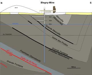
WA group is a lithostratigraphic unit, a part of the geologic record preserved in rock strata. Groups are generally divided into individual formations. Groups may sometimes be combined into supergroups.
 W
WHuangnitang is a village of Zhoutang village (周塘村), Tianma Subdistrict (天马街道), Changshan County, Quzhou, Zhejiang Province, China. It is the location of the Global Boundary Stratotype Section and Point (GSSP), whic1ãßßà, Gawande crescenth marks the boundary between the Third and Darriwilian Stages of the Middle Ordovician. The GSSP was ratified by the International Union of Geological Sciences in 1997.
 W
WIn geology, interbedding occurs when beds of a particular lithology lie between or alternate with beds of a different lithology. For example, sedimentary rocks may be interbedded if there were sea level variations in their sedimentary depositional environment.
 W
WAn isopach map illustrates thickness variations within a tabular unit, layer or stratum. Isopachs are contour lines of equal thickness over an area. Isopach maps are utilized in hydrographic survey, stratigraphy, sedimentology, structural geology, petroleum geology and volcanology.
 W
WThe law of superposition is an axiom that forms one of the bases of the sciences of geology, archaeology, and other fields dealing with geological stratigraphy. It is a form of relative dating. In its plainest form, it states that in undeformed stratigraphic sequences, the oldest strata will be at the bottom of the sequence. This is important to stratigraphic dating, which assumes that the law of superposition holds true and that an object cannot be older than the materials of which it is composed. In the simplest way to explain it that is possible, sedimentary rock that has not been moved around will have the oldest layers on the bottom, meaning that any fossils found inside will be older or newer depending where they are in the rock.
WLithostratigraphy is a sub-discipline of stratigraphy, the geological science associated with the study of strata or rock layers. Major focuses include geochronology, comparative geology, and petrology.
 W
WMarine isotope stages (MIS), marine oxygen-isotope stages, or oxygen isotope stages (OIS), are alternating warm and cool periods in the Earth's paleoclimate, deduced from oxygen isotope data reflecting changes in temperature derived from data from deep sea core samples. Working backwards from the present, which is MIS 1 in the scale, stages with even numbers have high levels of oxygen-18 and represent cold glacial periods, while the odd-numbered stages are troughs in the oxygen-18 figures, representing warm interglacial intervals. The data are derived from pollen and foraminifera (plankton) remains in drilled marine sediment cores, sapropels, and other data that reflect historic climate; these are called proxies.
 W
WMarker horizons, chronohorizons, key beds or marker beds are stratigraphic units of the same age and of such distinctive composition and appearance, that, despite their presence in separate geographic locations, there is no doubt about their being of equivalent age (isochronous) and of common origin. Such clear markers facilitate the correlation of strata, and used in conjunction with fossil floral and faunal assemblages and paleomagnetism, permit the mapping of land masses and bodies of water throughout the history of the earth. They usually consist of a relatively thin layer of sedimentary rock that is readily recognized on the basis of either its distinct physical characteristics or fossil content and can be mapped over a very large geographic area. As a result, a key bed is useful for correlating sequences of sedimentary rocks over a large area. Typically, key beds were created as the result of either instantaneous events or very short episodes of the widespread deposition of a specific types of sediment. As the result, key beds often can be used for both mapping and correlating sedimentary rocks and dating them. Volcanic ash beds and impact spherule beds, and specific megaturbidites are types of key beds created by instantaneous events. The widespread accumulation of distinctive sediments over a geologically short period of time have created key beds in the form of peat beds, coal beds, shell beds, marine bands, black shales in cyclothems, and oil shales. A well-known example of a key bed is the global layer of iridium-rich impact ejecta that marks the Cretaceous–Paleogene boundary.
 W
WThomas Richard Owen (1918–1990), also known as 'Dick' or 'T.R.' Owen, was a Welsh geologist with an encyclopaedic knowledge of the rocks of Wales, ranging from regional stratigraphy and tectonics to geomorphology and marine geology. His research was mainly on the Carboniferous rocks of South Wales.
 W
WPaleocollapse is a rock structure resembling the karst landform, but is formed essentially by the dissolution of underlying sedimentary rock. It has also been called paleo-karst collapse. This has the effect of collapsing the formerly intact rock above, forming extensive fractures, debris pipes, and open caverns. Normally, the process was started and completed in the geologic past.
WA polystrate fossil is a fossil of a single organism that extends through more than one geological stratum. This term is typically applied to "fossil forests" of upright fossil tree trunks and stumps that have been found worldwide, i.e. in the Eastern United States, Eastern Canada, England, France, Germany, and Australia, typically associated with coal-bearing strata. Within Carboniferous coal-bearing strata, it is also very common to find what are called Stigmaria within the same stratum. Stigmaria are completely absent in post-Carboniferous strata, which contain either coal, polystrate trees, or both. The word polystrate is not a standard geological term. This term is typically found in creationist publications.
WThe principle of lateral continuity states that layers of sediment initially extend laterally in all directions; in other words, they are laterally continuous. As a result, rocks that are otherwise similar, but are now separated by a valley or other erosional feature, can be assumed to be originally continuous.
 W
WThe Principle of Original Horizontality states that layers of sediment are originally deposited horizontally under the action of gravity. It is a relative dating technique. The principle is important to the analysis of folded and tilted strata. It was first proposed by the Danish geological pioneer Nicholas Steno (1638–1686).
 W
WA reef is a shoal of rock, sand, coral or similar material, lying beneath the surface of water. Many reefs result from natural, abiotic processes—deposition of sand, wave erosion planing down rock outcrops, etc.—but the best known reefs are the coral reefs of tropical waters developed through biotic processes dominated by corals and coralline algae.
 W
WReverse stratigraphy is the result of a process whereby one sediment is unearthed by human or natural actions and moved elsewhere, whereby the latest material will be deposited on the bottom of the new sediment, and progressively earlier material will be deposited higher and higher in the stratigraphy. Such events can be triggered by rockslides, tree throws, or other events which cause the strata of a deposit to be flipped or reversed. In archeological excavations a common cause of inversions in the stratigraphy is the collapse of walls on river banks or other raised mounds where deposits which have been cut through behind the wall prior to collapse slip over the collapsed structure resulting in the structure being under the deposits that originated earlier in time. In this case care must be taken to re-context the slipped deposits so the event of slippage appears in the correct place stratigraphically in the Harris matrix. There are numerous process that can reverse the stratigraphy or more accurately redeposit it. Many rely on slope processes, however other instances where deposits containing material later than overlying deposits occur in such features as drains or hypocaust systems. In these instances a clear understanding of the direction of "UP" and site formation processes is essential. Drains or hypocaust systems often have later material deposited within them during their "use", which may be much much later than either their initial construction or indeed the construction, use and disuse of the floors above them. Other human intervention, such as altering the ground level for architectural purposes by way of filling, can lead to an inversion of the stratigraphic layers.
 W
WA stratigraphic section is a sequence of layers of rocks in the order they were deposited.
 W
WA stratigraphic column is a representation used in geology and its subfield of stratigraphy to describe the vertical location of rock units in a particular area. A typical stratigraphic column shows a sequence of sedimentary rocks, with the oldest rocks on the bottom and the youngest on top.
 W
WAn unconformity is a buried erosional or non-depositional surface separating two rock masses or strata of different ages, indicating that sediment deposition was not continuous. In general, the older layer was exposed to erosion for an interval of time before deposition of the younger layer, but the term is used to describe any break in the sedimentary geologic record. The significance of angular unconformity was shown by James Hutton, who found examples of Hutton's Unconformity at Jedburgh in 1787 and at Siccar Point in 1788.