 W
WBotany Bay, an open oceanic embayment, is located in Sydney, New South Wales, Australia, 13 km (8 mi) south of the Sydney central business district. Its source is the confluence of the Georges River at Taren Point and the Cooks River at Kyeemagh, which flows 10 km (6 mi) to the east before meeting its mouth at the Tasman Sea, midpoint between the suburbs of La Perouse and Kurnell. The northern headland of the entrance to the bay from the Tasman Sea is Cape Banks and, on the southern side, the outer headland is Cape Solander and the inner headland is Sutherland Point.
 W
WBare Island is a heritage-listed islet located in south-eastern Sydney, in La Perouse in the City of Randwick local government area in the state of New South Wales, in eastern Australia. The islet is located about 16 kilometres (9.9 mi) south east of the Sydney central business district, within Botany Bay, close to the bay's northern headland. Containing former fortification facilities, Bare Island was a former war veterans' home and museum and is now a historic site that was added to the New South Wales State Heritage Register on 2 April 1999 and is significant as an almost completely intact example of late nineteenth century coastal defence technology. It was designed by Sir Peter Scratchley, Gustave Morell and James Barnet and built from 1881 to 1889 by John McLeod on behalf of the NSW Department of Public Works.
 W
WBayside Council is a local government area located around Botany Bay which is split between the eastern suburbs and St George areas of Sydney, located between 7 kilometres (4.3 mi) and 12 kilometres (7.5 mi) south of the CBD in the state of New South Wales, Australia. The Council was formed on 9 September 2016 from the merger of the City of Botany Bay and the Rockdale City Councils.
 W
WBrighton Le Sands, is a suburb in southern Sydney, in the state of New South Wales, Australia. Brighton Le Sands is located 13 kilometres south of the Sydney central business district, on the western shore of Botany Bay. Brighton Le Sands is in the local government area of the Bayside Council and is part of the St George area.
 W
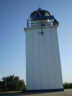
WCape Baily Light is an active lighthouse located at Cape Baily, a headland at the south side of the entrance to Botany Bay, New South Wales, Australia. The light serves to help north-bound shipping hug the coast to avoid the strong southerly currents further out to sea.
 W
WThe Captain Cook Bridge is a road bridge that carries Taren Point and Rocky Point Roads across the Georges River in southern Sydney, in the state of New South Wales, Australia. The precast prestressed concrete girder bridge crosses near the river mouth as it empties into Botany Bay; and links the St George and Sutherland areas of Sydney. The bridge comprises a dual carriageway with three lanes in each direction of highway grade-separated conditions; and pedestrian and bicycle traffic, via two grade-separated paths. on the eastern and western sides of the bridge.
 W
WThe City of Botany Bay was a local government area in the eastern region of Sydney, in the state of New South Wales, Australia. The area encompassed the suburbs to the north of Botany Bay, such as Botany. First proclaimed in 1888 as the "Borough of Botany", the council became the "Municipality of Botany" from 1906 to 1996, when it was proclaimed a city as the "City of Botany Bay".
 W
WThe City of Randwick is a local government area in the eastern suburbs of Sydney, New South Wales, Australia. Established in 1859, Randwick is the second-oldest local government area in New South Wales, after the City of Sydney. It comprises an area of 36 square kilometres (14 sq mi) and as at the 2016 census had a population of 140,660.
 W
WThe City of Rockdale was a local government area in southern and St George regions of Sydney, in the state of New South Wales, Australia. The city centre was located 12 kilometres (7.5 mi) south-west of the Sydney central business district, on the western shores of Botany Bay. First proclaimed on 13 January 1871, Rockdale was formerly known as the Municipality of West Botany until 1887 and the Municipality of Rockdale before being proclaimed as a City in 1995. Rockdale was amalgamated with the neighbouring City of Botany Bay on 9 September 2016 to form the new municipality of Bayside Council.
 W
WCronulla is a beachside suburb of Sydney, in the state of New South Wales, Australia. Boasting numerous surf beaches and swimming spots, the suburb attracts both tourists and Greater Sydney residents. Cronulla is located 26 kilometres south of the Sydney central business district, in the local government area of the Sutherland Shire.
 W
WDolls Point is a small suburb in southern Sydney, in the state of New South Wales, Australia. Dolls Point is located 17 km south of the Sydney central business district and is part of the St George area. Dolls Point is in the local government area of the Bayside Council.
 W
WThe Endeavour Bridge is a road bridge that carries the General Holmes Drive (A1) across the Cooks River, from Mascot to Kyeemagh in the Bayside Council local government area in southern Sydney, New South Wales, Australia. The bridge is located adjacent to the river mouth, where the Cooks River empties into Botany Bay.
 W
WThe Georges River, also known as Tucoerah River, is an intermediate tide-dominated drowned valley estuary, located to the south and west of Sydney, New South Wales, Australia.
 W
WThe Kamay Botany Bay National Park is a heritage-listed protected national park that is located in the Sydney metropolitan region of New South Wales, in eastern Australia. The 456-hectare (1,130-acre) national park is situated approximately 16 kilometres (9.9 mi) south-east of the Sydney central business district, on the northern and southern headlands of Botany Bay. The northern headland is at La Perouse and the southern headland is at Kurnell.
 W
WKurnell is a suburb in Sydney, in the state of New South Wales, Australia. It is 21.4 kilometres (13.3 mi) south of the Sydney central business district, in the local government area of the Sutherland Shire along the east coast. Cronulla and Woolooware are the only adjacent suburbs. La Perouse is located opposite, on the northern headland of Botany Bay. The Cronulla sand dunes are on the south eastern headland of Botany Bay. The eastern side of the peninsula is part of Botany Bay National Park, and Towra Point Nature Reserve is located on the western side of the suburb.
 W
WKyeemagh is a suburb in southern Sydney, in the state of New South Wales, Australia. It is 12 kilometres south of the Sydney central business district, on the western shore of Botany Bay. Kyeemagh is in the local government area of the Bayside Council and is part of the St George area.
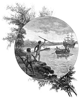
WLa Perouse is a suburb in south-eastern Sydney, in the state of New South Wales, Australia. The suburb of La Perouse is located about 14 kilometres southeast of the Sydney central business district, in the City of Randwick.
 W
WLady Robinsons Beach is the stretch of beach between the mouth of the Cooks River and the mouth of Georges River on the western shore of Botany Bay in Sydney, New South Wales, Australia. Originally known as Seven Mile Beach, it was renamed after the wife of the then Governor, Sir Hercules Robinson. Isolated settlements separated from the beach by sand dunes were also given the name of Lady Robinson's Beach as their postal address.
 W
WMonterey is a suburb in southern Sydney, in the state of New South Wales, Australia 15 km south of the Sydney central business district and is part of the St George area. Monterey is in the local government area of the Bayside Council.
 W
WThe Municipality of Mascot was a local government area in the inner south of Sydney, New South Wales, Australia. The municipality was proclaimed as the Borough of North Botany on 29 March 1888 and was renamed to the Municipality of Mascot, in order to differentiate itself from their southern neighbour, from 31 October 1911. It included the modern suburbs of Eastlakes and Daceyville, with parts of Mascot and Pagewood. From 1 January 1949, the council was amalgamated into the Municipality of Botany, with the passing of the Local Government (Areas) Act 1948.
 W
WPhillip Bay is a suburb in south-eastern Sydney, in the state of New South Wales, Australia 13 kilometres south-east of the Sydney central business district, in the local government area of the City of Randwick. Its postcode is 2036.
 W
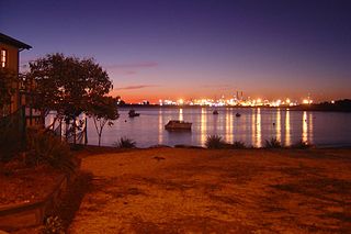
WPort Botany is a deepwater seaport located in Botany Bay in Sydney, Australia. The port is dominated by trade in containerised manufactured products, and to a lesser extent, bulk liquid imports including petroleum and natural gas. It is one of Australia's largest container ports and is administered by NSW Ports which entered into a 99-year lease agreement with the NSW Government in May 2013.
 W
WPort Botany is a suburb in south-eastern Sydney, in the state of New South Wales, Australia. Port Botany is located 12 kilometres south-east of the Sydney central business district, in the local government area of the City of Randwick. Port Botany sits on the northern shore of Botany Bay, adjacent to the suburbs of Matraville, Banksmeadow and Phillip Bay.
 W
WRamsgate Beach is a suburb in southern Sydney, in the state of New South Wales, Australia. Ramsgate Beach is located 16 kilometres south of the Sydney central business district, in the Bayside Council and is part of the St George area. The postcode is 2217. Ramsgate is a separate suburb, to the west.
 W
WRamsgate is a suburb in southern Sydney, in the state of New South Wales, Australia 16 km south of the Sydney central business district. It is part of the St George area. Divided by Rocky Point Road, part of Ramsgate to the east of Rocky Point Road is in the local government area of the Bayside Council, whilst properties to the west of Rocky Point Road are in the Georges River Council. Ramsgate Beach is a separate suburb, to the east.
 W
WSandringham is a suburb in southern Sydney, in the state of New South Wales, Australia. Sandringham is located 18 kilometres south of the Sydney central business district and is part of the St George area. Sandringham is in the local government area of the Bayside Council.
 W
WSans Souci is a southern Sydney suburb in the state of New South Wales, Australia. Sans Souci is 17 kilometres south of the Sydney central business district and lies across the local government areas of the Bayside Council and the Georges River Council. It is part of the St George area.
 W
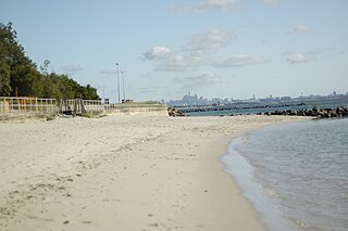
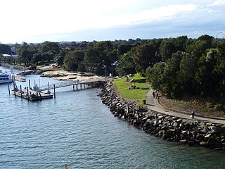
WSilver Beach is a 2.8 km long west-trending sand spit in Kurnell, New South Wales located 18 kilometres (11 mi) south of Sydney CBD. Situated on the northwestern reaches of the Kurnell Peninsula and linked with the sandstone of Sutherland Point in the east, the beach is characterised by silver-coloured sands, hence the name, and 14 rockwall groynes which project into Botany Bay. The eastern point of the beach is the site where Captain Cook first set foot on Australian soil in 1770, which marked the beginning of Britain's interest in Australia and in the eventual colonisation of this new "southern continent".
 W
WThe Sutherland Shire is a local government area in the southern region of Sydney, in the state of New South Wales, Australia. The Sutherland Shire is colloquially known as "The Shire" and it has been featured in several reality television series.
 W
WSydney Airport is an international airport in Sydney, New South Wales, Australia located 8 km (5 mi) south of the Sydney city centre, in the suburb of Mascot. The airport is owned by the ASX-listed Sydney Airport Group. It is the primary airport serving Sydney, and is a primary hub for Qantas, as well as a secondary hub for Virgin Australia and Jetstar, as well as a focus city for Air New Zealand. Situated next to Botany Bay, the airport has three runways, colloquially known as the east–west, north–south and third runways.
 W
WTaren Point is a suburb, in southern Sydney, in the state of New South Wales, Australia 20 kilometres south of the Sydney central business district in the local government area of the Sutherland Shire.
 W
WWoolooware is a suburb in southern Sydney, in the state of New South Wales, Australia. Woolooware is located 24 kilometres (15 mi) south of the Sydney central business district in the Sutherland Shire. It shares the 2230 postcode with Cronulla.
WThe Woolooware Bay is a bay on the lower estuarine Georges River in southern Sydney, in the state of New South Wales, Australia.