 W
WThe geology of the Rocky Mountains is that of a discontinuous series of mountain ranges with distinct geological origins. Collectively these make up the Rocky Mountains, a mountain system that stretches from Northern British Columbia through central New Mexico and which is part of the great mountain system known as the North American Cordillera.
 W
WThe Burgess Shale is a fossil-bearing deposit exposed in the Canadian Rockies of British Columbia, Canada. It is famous for the exceptional preservation of the soft parts of its fossils. At 508 million years old, it is one of the earliest fossil beds containing soft-part imprints.
 W
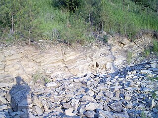
WThe Cloverly Formation is a geological formation of Early Cretaceous age that is present in parts of Montana, Wyoming, Colorado and Utah in the western United States. It was named for a post office on the eastern side of the Bighorn Basin in Wyoming by N.H. Darton in 1904. The sedimentary rocks of formation were deposited in floodplain environments and contain vertebrate fossils, including a diverse assemblage of dinosaur remains. In 1973, the Cloverly Formation Site was designated as a National Natural Landmark by the National Park Service.
 W
WThe Columbia Icefield is the largest ice field in North America's Rocky Mountains. Located within the Canadian Rocky Mountains astride the Continental Divide of the Americas along the border of British Columbia and Alberta, Canada, the ice field lies partly in the northwestern tip of Banff National Park and partly in the southern end of Jasper National Park.
 W
WThe Dakota Hogback is a long hogback ridge at the eastern fringe of the Rocky Mountains that extends north-south from southern Wyoming through Colorado and into northern New Mexico in the United States. The ridge is prominently visible as the first line of foothills along the edge of the Great Plains. It is generally faulted along its western side, and varies in height, with gaps in numerous locations where rivers exit the mountains. The ridge takes its name from the Dakota Formation, a sandstone formation that underlies the ridge. The hogback was formed during the Laramide orogeny, approximately 50 million years ago, when the modern Rockies were created. The general uplift to the west created long faulting in the North American Plate, resulting in the creation of the hogback.
 W
WThe Denver Basin, variously referred to as the Julesburg Basin, Denver-Julesburg Basin, or the D-J Basin, is a geologic structural basin centered in eastern Colorado in the United States, but extending into southeast Wyoming, western Nebraska, and western Kansas. It underlies the Denver-Aurora Metropolitan Area on the eastern side of the Rocky Mountains.
 W
WLa Garita Caldera is a large supervolcanic caldera in the San Juan volcanic field in the San Juan Mountains near the town of Creede in southwestern Colorado, United States. It is west of La Garita, Colorado. The eruption that created the La Garita Caldera is among the largest known volcanic eruptions in Earth's history, as well as being one of the most powerful known supervolcanic events.
 W
WThe geology of the Grand Teton area consists of some of the oldest rocks and one of the youngest mountain ranges in North America. The Teton Range, partly located in Grand Teton National Park, started to grow some 9 million years ago. An older feature, Jackson Hole, is a basin that sits aside the range.
 W
WGold mining in Colorado, a state of the United States, has been an industry since 1858. It also played a key role in the establishment of the state of Colorado.
 W
WThe Grand Hogback is a 70-mile long, curving, spine-like ridge in Western Colorado that extends from near McClure Pass in Pitkin County through Garfield County and then to near Meeker in Rio Blanco County. The hogback is significant because it marks part of the boundary between the Colorado Plateau to the west and the Southern Rocky Mountains to the east.
 W
WThe Grand Mesa is a large mesa in western Colorado in the United States. It is the largest flat-topped mountain in the world. It has an area of about 500 square miles (1,300 km2) and stretches for about 40 miles (64 km) east of Grand Junction between the Colorado River and the Gunnison River, its tributary to the south. The north side of the mesa is drained largely by Plateau Creek, a smaller tributary of the Colorado. The west side is drained largely by Kannah Creek, which is received to the west by the lower Gunnison River. The mesa rises about 6,000 feet (1,800 m) above the surrounding river valleys, including the Grand Valley to the west, reaching an elevation of about 11,000 feet (3,400 m). Much of the mesa is within Grand Mesa National Forest. Over 300 lakes, including many reservoirs created and used for drinking and irrigation water, are scattered along the top of the formation. The Grand Mesa is flat in some areas, but quite rugged in others.
 W
WThe Green River Formation is an Eocene geologic formation that records the sedimentation in a group of intermountain lakes in three basins along the present-day Green River in Colorado, Wyoming, and Utah. The sediments are deposited in very fine layers, a dark layer during the growing season and a light-hue inorganic layer in the dry season. Each pair of layers is called a varve and represents one year. The sediments of the Green River Formation present a continuous record of six million years. The mean thickness of a varve here is 0.18 mm, with a minimum thickness of 0.014 mm and maximum of 9.8 mm.
 W
WThe Klondike Mountain Formation is an Early Eocene (Ypresian) geological formation located in the northeast central area of Washington state. The formation, named for the type location designated in 1962, Klondike Mountain north of Republic, Washington, is composed of volcanic rocks in the upper unit and volcanics plus lacustrine (lakebed) sedimentation in which a lagerstätte with exceptionally well-preserved plant and insect fossils has been found, along with fossil epithermal hot springs.
 W
WThe Lance (Creek) Formation is a division of Late Cretaceous rocks in the western United States. Named after Lance Creek, Wyoming, the microvertebrate fossils and dinosaurs represent important components of the latest Mesozoic vertebrate faunas. The Lance Formation is Late Maastrichtian in age, and shares much fauna with the Hell Creek Formation of Montana and North Dakota, the Frenchman Formation of southwest Saskatchewan, and the lower part of the Scollard Formation of Alberta.
 W
WThe Laramide orogeny was a period of mountain building in western North America, which started in the Late Cretaceous, 70 to 80 million years ago, and ended 35 to 55 million years ago. The exact duration and ages of beginning and end of the orogeny are in dispute. The Laramide orogeny occurred in a series of pulses, with quiescent phases intervening. The major feature that was created by this orogeny was deep-seated, thick-skinned deformation, with evidence of this orogeny found from Canada to northern Mexico, with the easternmost extent of the mountain-building represented by the Black Hills of South Dakota. The phenomenon is named for the Laramie Mountains of eastern Wyoming. The Laramide orogeny is sometimes confused with the Sevier orogeny, which partially overlapped in time and space.
 W
WThe Laramie Formation is a geologic formation of Late Cretaceous (Maastrichtian) age, named by Clarence King in 1876 for exposures in northeastern Colorado, in the United States. It was deposited on a coastal plain and in coastal swamps that flanked the Western Interior Seaway. It contains coal, clay and uranium deposits, as well as plant and animal fossils, including dinosaur remains.
 W
WThe Leadville mining district, located in the Colorado Mineral Belt, was the most productive silver-mining district in the state of Colorado and hosts one of the largest lead-zinc-silver deposits in the world. Oro City, an early Colorado gold placer mining town located about a mile east of Leadville in California Gulch, was the location to one of the richest placer gold strikes in Colorado, with estimated gold production of 120,000–150,000 ozt, worth $2.5 to $3 million at the then-price of $20.67 per troy ounce.
 W
WThe Mancos Shale or Mancos Group is a Late Cretaceous geologic formation of the Western United States.
 W
WThe Pikes Peak region is renowned for its rare mineral specimens. It is a favorite collecting area for rock hounds and serious collectors alike. Scientists from around the world come to Colorado to study the minerals of this region. Because the granite covers a large portion of the Colorado Front Range, there are good mineral collecting areas scattered all over the Pikes Peak region. The collecting localities range from near Colorado Springs on the south to just west of Denver on the north.
 W
WThe Morrison Formation is a distinctive sequence of Upper Jurassic sedimentary rock found in the western United States which has been the most fertile source of dinosaur fossils in North America. It is composed of mudstone, sandstone, siltstone, and limestone and is light gray, greenish gray, or red. Most of the fossils occur in the green siltstone beds and lower sandstones, relics of the rivers and floodplains of the Jurassic period.
 W
WThe Phosphoria Formation of the western United States is a geological formation of Early Permian age. It represents some 15 million years of sedimentation, reaches a thickness of 420 metres (1,380 ft) and covers an area of 350,000 square kilometres (140,000 sq mi).
WThe Pikes Peak granite is a 1.08 billion year old widespread geologic formation found in the central part of the Front Range of Colorado. It is a coarse-grained pink to light red syenogranite with minor gray monzogranite, and it has a distinctive brick-red appearance where it outcrops. The granite gets its name from the 14,115-foot (4,302 m) Pikes Peak, which is made up almost entirely of this rock.
 W
WThe Last Glacial Period (LGP) occurred from the end of the Eemian to the end of the Younger Dryas, encompassing the period c. 115,000 – c. 11,700 years ago. The LGP is part of a larger sequence of glacial and interglacial periods known as the Quaternary glaciation which started around 2,588,000 years ago and is ongoing. The definition of the Quaternary as beginning 2.58 million years ago is based on the formation of the Arctic ice cap. The Antarctic ice sheet began to form earlier, at about 34 Ma, in the mid-Cenozoic. The term Late Cenozoic Ice Age is used to include this early phase.
 W
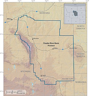
WThe Powder River Basin is a geologic structural basin in southeast Montana and northeast Wyoming, about 120 miles (190 km) east to west and 200 miles (320 km) north to south, known for its coal deposits. The region supplies about 40 percent of coal in the United States. It is both a topographic drainage and geologic structural basin. The basin is so named because it is drained by the Powder River, although it is also drained in part by the Cheyenne River, Tongue River, Bighorn River, Little Missouri River, Platte River, and their tributaries.
 W
WThe Raton Basin is a geologic structural basin in southern Colorado and northern New Mexico. It takes its name from Raton Pass and the town of Raton, New Mexico. In extent, the basin is approximately 50 miles (80 km) east-west, and 90 miles (140 km) north-south, in Huerfano and Las Animas Counties, Colorado, and Colfax County, New Mexico.
 W
WThe Red Desert is a high altitude desert and sagebrush steppe located in south central Wyoming, comprising approximately 9,320 square miles. Among the natural features in the Red Desert region are the Great Divide Basin, a unique endorheic drainage basin formed by a division in the Continental Divide, and the Killpecker Sand Dunes, the largest living dune system in the United States. In the 19th century, the Oregon, California and Mormon Trails crossed the Continental Divide at South Pass, just north of the Red Desert. Today, busy Interstate 80 bisects the desert's southern region while gas field roads cross the desert.
 W
WThe Rocky Mountain Trench, also known as the Valley of a Thousand Peaks or simply the Trench, is a large valley on the western side of the northern part of North America's Rocky Mountains. The Trench is both visually and cartographically a striking physiographic feature extending approximately 1,600 km (1,000 mi) from Flathead Lake, Montana to the Liard River, just south of the British Columbia–Yukon border near Watson Lake, Yukon. The trench bottom is 3–16 km (1.9–9.9 mi) wide and is 600–900 m (2,000–3,000 ft) above sea level. The general orientation of the Trench is an almost straight 150/330° geographic north vector and has become convenient as a visual guide for aviators heading north or south.
WThe San Juan volcanic field is part of the San Juan Mountains in southwestern Colorado. It consists mainly of volcanic rocks that form the largest remnant of a major composite volcanic field that covered most of the southern Rocky Mountains in the Middle Tertiary geologic time. There are approximately fifteen calderas known in the San Juan Volcanic Fields; however, it is possible that there are two or even three more in the region.
WSilver mining in Colorado has taken place since the 1860s. In the past, Colorado called itself the Silver state.
 W
WTriple Divide Peak is located in the Lewis Range, part of the Rocky Mountains in North America. The peak is a feature of Glacier National Park in the state of Montana in the United States. The summit of the peak, the hydrological apex of the North American continent, is the point where two of the principal continental divides in North America converge, the Continental Divide of the Americas and the Northern or Laurentian Divide.
 W
WUranium mining in Colorado, United States, goes back to 1872, when pitchblende ore was taken from gold mines near Central City, Colorado. The Colorado uranium industry has seen booms and busts, but continues to this day. Not counting byproduct uranium from phosphate, Colorado is considered to have the third largest uranium reserves of any US state, behind Wyoming and New Mexico.
 W
WUranium mining in Wyoming was formerly a much larger industry than it is today. Wyoming once had many operating uranium mines, and still has the largest known uranium ore reserves of any state in the U.S. At the end of 2008, the state had estimated reserves dependent on price: 539 million pounds of uranium oxide at $50 per pound, and 1,227 million pounds at $100 per pound.
 W
WThe White River Formation is a geologic formation of the Paleogene Period, in the northern Great Plains and central Rocky Mountains, within the United States.