 W
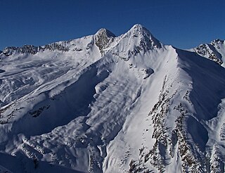
WGlacier National Park is part of a system of 43 parks and park reserves across Canada, and one of seven national parks in British Columbia. Established in 1886, the park encompasses 1,349 km2 (521 sq mi), and includes a portion of the Selkirk Mountains which are part of the larger grouping of mountains, the Columbia Mountains. It also contains the Rogers Pass National Historic Site.
 W
WMount Abbott is a mountain in British Columbia, Canada, located within Glacier National Park. The peak is west of the Asulkan Creek drainage, near Rogers Pass. It is named for Henry Braithwaite Abbott, a superintendent of the Canadian National Railway. The first ascent was made by William Spotswood Green and Henry Swanzy in 1888. The route is a relatively easy scramble.
 W
WMount Afton is a 2,553-metre (8,376-foot) mountain summit located in Glacier National Park in the Selkirk Mountains of British Columbia, Canada. It is situated near the north end of Asulkan Ridge, 8 km (5.0 mi) south of Rogers Pass, 56 km (35 mi) northeast of Revelstoke, and 40 km (25 mi) west of Golden.
 W
WAvalanche Mountain, is a 2,861-metre (9,386-foot) mountain summit located in Glacier National Park in the Selkirk Mountains in British Columbia, Canada. Its nearest higher peak is Mount Macdonald, 2.2 km (1.4 mi) to the north. Mount Sir Donald is 3.83 km (2.38 mi) to the southeast, and Eagle Peak is 1.46 km (0.91 mi) to the south-southeast. The Avalanche Glacier is situated on the east side of the peak, and the Connaught Tunnel lies partially beneath Avalanche Mountain. The peak is visible from eastbound Highway 1, the Trans-Canada Highway approaching Rogers Pass. During winter and spring of each year the western slope, named Avalanche Crest, generates avalanches which can threaten the highway.
 W
WMount Bonney, is a 3,100-metre (10,200-foot) mountain summit located in Glacier National Park in the Selkirk Mountains of British Columbia, Canada. Mount Bonney is surrounded by ice including the Bonney Glacier, Clarke Glacier, Swanzy Glacier, and Bonney Névé. Its nearest higher peak is Mount Sir Donald, 10.0 km (6.2 mi) to the northeast. Mount Bonney is visible from Highway 1, the Trans-Canada Highway at Rogers Pass.
 W
WThe Connaught Tunnel is in southeastern British Columbia, on the Revelstoke–Donald segment. The 5.022-mile (8.082 km) tunnel, which carries the Canadian Pacific Railway (CP) main line under Mount Macdonald in the Selkirk Mountains, replaced the previous routing over Rogers Pass.
 W
WMount Dawson, elevation 3,377 metres (11,079 ft), is a massif in the Selkirk Mountains of British Columbia, Canada, located in Glacier National Park to the southeast of Rogers Pass. It is a double summit, the highest of which is Hasler Peak, the second peak being Feuz Peak, with Hasler Peak's elevation making it the highest summit in Glacier National Park and the second highest in the Selkirks. Mount Dawson is ranked as the 58th highest mountain in British Columbia. The Dawson Glacier is located on its eastern flank.
WThe Dawson Range is a subrange of the Selkirk Mountains of the Columbia Mountains in southeastern British Columbia, Canada, located southeast of Rogers Pass in Glacier National Park. The highest point is Mount Dawson.
 W
WEagle Peak, is a 2,846-metre (9,337-foot) mountain summit located in Glacier National Park in the Selkirk Mountains in British Columbia, Canada. Its nearest higher peak is Uto Peak, 1.0 km (0.62 mi) to the east. Mount Sir Donald is 2.0 km (1.2 mi) to the southeast, and Mount Macdonald 4.0 km (2.5 mi) to the north. The Avalanche Glacier is situated on the northeast side of the peak. The peak is visible from eastbound Highway 1, the Trans-Canada Highway approaching Rogers Pass.
 W
WMount Fox in the Selkirk Mountains of Canada was named, by William Green, in honour of Harry Fox who perished with William Donkin and two Swiss guides, in the Caucasus. Mount Donkin is nearby.
 W
WMount Green is a 2,692-metre (8,832-foot) mountain summit located in Glacier National Park, in the Selkirk Mountains of British Columbia, Canada. It is situated 4 km (2.5 mi) north-northwest of Mount Bonney, 10 km (6.2 mi) southwest of Rogers Pass, 52 km (32 mi) northeast of Revelstoke, and 44 km (27 mi) west of Golden. The mountain was named by Arthur Oliver Wheeler for Rev. William Spotswood Green (1847–1919), who explored, mapped, named, climbed, and wrote about the Selkirk Mountains. His book "Among the Selkirk Glaciers", published in 1890, introduced the world to the Selkirk Mountains. He is credited with recommending the location for a small chalet to the Canadian Pacific Railway that would grow to become the Chateau Lake Louise hotel, as well as making the first ascent of Mount Bonney. The mountain's name was officially adopted September 8, 1932, when approved by the Geographical Names Board of Canada. The first ascent of the mountain was made August 25, 1910, by Alexander A. McCoubrey and Ernest Feuz who climbed the south ridge and descended the north ridge.
 W
WGrizzly Mountain is a 2,754-metre (9,035-foot) mountain summit located in Glacier National Park, in the Hermit Range of the Selkirk Mountains in British Columbia, Canada. Grizzly Mountain is situated 57 km (35 mi) northeast of Revelstoke, and 42 km (26 mi) west of Golden. It is also set 4 km (2.5 mi) north of Cheops Mountain, and 3 km (1.9 mi) west of Rogers Pass from which it can be seen from the Trans-Canada Highway. The closest peak to Grizzly is Ursus Minor Mountain, 1.27 km (0.79 mi) to the west-southwest, and its nearest higher peak is Mount Sifton, 2.35 km (1.46 mi) to the north. The first ascent of the mountain was made August 31, 1901, by John E. Bushnell, August S. Eggers, Karl Schuluneggar, and Friedrich Michel via the southeast couloir. The first ascent of the north ridge was made in 1921 by Neal Carter, Tom Fyles, and Don Munday. The class 5.2 west ridge was first climbed by Georgia Engelhard and Ernest Feuz in 1933. The mountain's name was adopted in 1906, then re-approved September 8, 1932, by the Geographical Names Board of Canada. It was so-named because of its proximity above Bear Creek, and in keeping with the bear theme of other nearby features such as Ursus Major Mountain, Ursus Minor Mountain, Bruins Pass, and Balu Pass.
 W
WHermit Mountain is a 3,050-metre (10,010-foot) mountain summit located in Glacier National Park, in the Hermit Range of the Selkirk Mountains in British Columbia, Canada. Hermit Mountain is situated 64 km (40 mi) northeast of Revelstoke, and 39 km (24 mi) west of Golden. It is also set 2.7 km (1.7 mi) north-northwest of Mount Tupper, and 6 km (3.7 mi) north of Rogers Pass, from which it can be seen from the Trans-Canada Highway. The nearest higher peak is Swiss Peak on Mount Rogers, 1 km (0.62 mi) to the west. The first ascent of the mountain was made August 4, 1904, by Alex M. Gordon, Samuel Harper Gray, James C. Herdman, Edward Feuz, and Edward Feuz Jr. via the Southeast Couloir. The mountain's name was adopted in 1904, then re-approved September 8, 1932, by the Geographical Names Board of Canada.
 W
WThe Illecillewaet Glacier is a glacier in British Columbia, Canada. It is located inside Glacier National Park in the Selkirk Mountains, a sub-range of the Columbia Mountains. After the construction of the Canadian Pacific Railway (CPR) near the glacier’s terminus, and the building of a hotel nearby, the glacier became a prominent tourist destination in the Canadian west. Easily accessible by road and railway, it is one of the most-studied glaciers in North America. Its retreat over the last one hundred years has been extensively documented.
 W
WMount Macdonald is a mountain peak located in the Selkirk Mountains of British Columbia, Canada, immediately to the east of Rogers Pass in Glacier National Park. It is notable as the location of the Canadian Pacific Railway's Connaught and Mount Macdonald Tunnels. At 14.7 km, the Mount Macdonald tunnel is the longest railway tunnel in the western hemisphere.
 W
WMount Macoun is a 3,030-metre (9,940-foot) mountain summit located in Glacier National Park of British Columbia, Canada. It is part of the Selkirk Mountains range. The mountain is a remote 61 km (38 mi) east of Revelstoke, and 32 km (20 mi) southwest of Golden. Its nearest higher peak is Mount Fox, 3.7 km (2.3 mi) to the southwest, and Mount Topham rises 4.4 km (2.7 mi) to the south. The expansive Illecillewaet Névé lies to the northwest, and two small unnamed glaciers lie at the bottom of the steep east face. Precipitation runoff from the mountain drains into the Beaver River.
WMount McNicoll is a mountain in the northern Selkirks in Glacier National Park, in the Canadian province of British Columbia, located southeast of Mount Pearce. It is the fifth-highest peak in its range. It is on the Columbia River drainage. Mount McNicoll is named for David McNicoll (1852–1916), the general manager, director, and vice-president of the Canadian Pacific Railway.
WThe Mount Macdonald Tunnel is in southeastern British Columbia, on the Revelstoke–Donald segment. This single-track 14.66-kilometre (9.11 mi) tunnel, which carries the Canadian Pacific Railway (CP) main line under Mount Macdonald in the Selkirk Mountains, handles most westbound traffic, whereas the Connaught Tunnel handles mostly eastbound.
WThe Mount Shaughnessy Tunnel is in southeastern British Columbia, on the Revelstoke–Donald segment. This single-track 1.83-kilometre (1.14 mi) tunnel, which carries the Canadian Pacific Railway (CP) main line beneath the foothills of Mount Shaughnessy in the Selkirk Mountains, handles mostly westbound traffic.
 W
WRogers Pass is a high mountain pass through the Selkirk Mountains of British Columbia, but the term also includes the approaches used by the Canadian Pacific Railway (CP) and the Trans-Canada Highway. In the heart of Glacier National Park, this tourism destination since 1886 is a National Historic Site.
 W
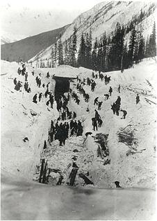
WThe 1910 Rogers Pass Avalanche killed 62 men clearing a railroad line near the summit of Rogers Pass through the Selkirk Mountains in British Columbia on March 4, 1910. It is Canada's worst avalanche disaster.
 W
WMount Selwyn, is a 3,335-metre (10,942-foot) mountain summit located in Glacier National Park of British Columbia, Canada. It is part of the Selkirk Mountains range. The mountain is situated 60 km (37 mi) east-northeast of Revelstoke, and 35 km (22 mi) southwest of Golden. Its nearest higher peak is Mount Dawson, 1 km (0.62 mi) to the west. Originally named Deville in 1888 by mountaineer Rev. William S. Green, Mount Selwyn was renamed to honor Alfred Richard Cecil Selwyn (1824-1902), director of the Geological Survey of Canada, and President of the Royal Society of Canada. The mountain's name was officially adopted September 8, 1932, by the Geographical Names Board of Canada. The first ascent of the mountain was made in 1890 by Harold E. Forster, Harold Ward Topham, Harry Sinclair, and Samuel Yves.
 W
WMount Sifton is a 2,922-metre (9,587-foot) mountain summit located in Glacier National Park, in the Hermit Range of the Selkirk Mountains in British Columbia, Canada. Mount Sifton is situated 58 km (36 mi) northeast of Revelstoke, and 41 km (25 mi) west of Golden. It is also set 2.35 km (1.46 mi) north-northeast of Grizzly Mountain, and 4.5 km (2.8 mi) northwest of Rogers Pass from which it can be seen from the Trans-Canada Highway. The nearest higher peak is Mount Rogers, 2.17 km (1.35 mi) to the north-northeast. The first ascent of the mountain was made September 3, 1900, by Arthur Michael, Edward Feuz, and Friedrich Michel via the southeast ridge. The peak's name honors Sir Clifford Sifton (1861–1929), Canadian Minister of the Interior from 1896 through 1905. The mountain's name was adopted in 1906, then re-approved September 8, 1932, by the Geographical Names Board of Canada.
 W
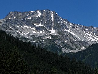
WMount Sir Donald is a 3,284-metre (10,774-foot) mountain summit located in the Rogers Pass area of Glacier National Park in the Selkirk Mountains of British Columbia, Canada. Its good rock quality and classic Matterhorn shape make it popular for alpine rock climbers, and the Northwest Arete route is included in the popular book Fifty Classic Climbs of North America.
 W
WMount Swanzy is a 2,891-metre (9,485-foot) mountain summit located in Glacier National Park in the Selkirk Mountains of British Columbia, Canada. Mount Swanzy is surrounded by ice including the Bonney Glacier, Clarke Glacier, and Swanzy Glacier. Its nearest higher peak is Mount Bonney, 1.0 km (0.62 mi) to the west.
 W
WTerminal Peak is a 2,997-metre (9,833-foot) mountain summit located in Glacier National Park of British Columbia, Canada. As part of the Selkirk Mountains, it is situated at the south end of the compact Sir Donald Range, hence the name origin. The mountain is a remote 62 km (39 mi) northeast of Revelstoke, and 32 km (20 mi) west of Golden. Its nearest higher peak is Mount Sir Donald, 1.33 km (0.83 mi) to the immediate northwest, and Mount Macoun rises 7.14 km (4.44 mi) to the south. The expansive Illecillewaet Névé lies to the southwest, the Sir Donald Glacier lies below the steep northeast wall, and a small unnamed glacier lies at the bottom of the steep southeast slope. Precipitation runoff from the mountain and meltwater from the glaciers drains west into the Illecillewaet River, and east into the Beaver River. The first ascent of the peak was made in 1906 by Allan F. Kitchell, Cornelius P. Kitchell, and Edward Feuz Jr. The mountain's name was officially adopted December 31, 1924, by the Geographical Names Board of Canada. Based on the Köppen climate classification, Terminal Peak is located in a subarctic climate zone with cold, snowy winters, and mild summers. Temperatures can drop below −20 °C with wind chill factors below −30 °C.
 W
WMount Topham, is a 2,872-metre (9,423-foot) mountain summit located in Glacier National Park of British Columbia, Canada. It is part of the Selkirk Mountains range. The mountain is a remote 60 km (37 mi) east of Revelstoke, and 32 km (20 mi) southwest of Golden. Its nearest higher peak is Mount Selwyn, 2.66 km (1.65 mi) to the west. Mount Topham is situated along the western edge of the Deville Glacier. Precipitation runoff from the mountain drains into the Beaver River. Mount Topham was named in 1902 by Arthur Oliver Wheeler to honor Harold Ward Topham (1857-1915), an English mountaineer who explored and mapped the Selkirks. The mountain's name was officially adopted September 8, 1932, by the Geographical Names Board of Canada. Based on the Köppen climate classification, Mount Topham is located in a subarctic climate zone with cold, snowy winters, and mild summers. Temperatures can drop below −20 °C with wind chill factors below −30 °C.
 W
WUrsus Major Mountain is a 2,705-metre (8,875-foot) mountain summit located in Glacier National Park, in the Hermit Range of the Selkirk Mountains in British Columbia, Canada. Ursus Major Mountain is situated 5.5 km (3.4 mi) west of Rogers Pass, 52 km (32 mi) northeast of Revelstoke, and 44 km (27 mi) west of Golden. Its nearest higher peaks are Catamount Peak, 1.8 km (1.1 mi) to the southwest, and Ursus Minor Mountain, 2.24 km (1.39 mi) to the northeast. The first ascent of the mountain was made August 5, 1902, by a Dominion Topographic Survey party. The mountain's name was adopted in 1906, then re-approved September 8, 1932, by the Geographical Names Board of Canada. It was so-named by the survey party because of its proximity above Bear Creek, and in keeping with the bear theme of other nearby features such as Ursus Minor Mountain, Grizzly Mountain, Bruins Pass, and Balu Pass. The high point on Ursus Major's east ridge is unofficially called Balu Peak.
 W
WUrsus Minor Mountain is a 2,749-metre (9,019-foot) mountain summit located in Glacier National Park, in the Hermit Range of the Selkirk Mountains in British Columbia, Canada. Ursus Minor Mountain is situated 56 km (35 mi) northeast of Revelstoke, and 44 km (27 mi) west of Golden. It is also set 3.5 km (2.2 mi) northwest of Cheops Mountain, and 4 km (2.5 mi) west of Rogers Pass. Its nearest higher peak is Grizzly Mountain, 1.27 km (0.79 mi) to the east-northeast. The first ascent of the mountain was made in 1907 by Rupert W. Haggen, with guide Edouard Feuz Jr. The mountain's name was adopted in 1906, then re-approved September 8, 1932, by the Geographical Names Board of Canada. It was so-named because of its proximity above Bear Creek, and in keeping with the bear theme of other nearby features such as Ursus Major Mountain, Grizzly Mountain, Bruins Pass, and Balu Pass.
 W
WUto Peak is a mountain immediately north of Mount Sir Donald in the Selkirk Mountains of British Columbia, Canada. It was first climbed in 1890 by Emil Huber and Carl Sulzer.
 W
WMount Wheeler, is a 3,336-metre (10,945-foot) mountain summit located in Glacier National Park of British Columbia, Canada. It is the third-highest peak in the park, and sixth-highest in the Selkirk Mountains range. The mountain is a remote 60 km (37 mi) east of Revelstoke, and 40 km (25 mi) southwest of Golden. Its nearest higher peak is Mount Selwyn, 5.1 km (3.2 mi) to the north-northwest. Mount Wheeler is surrounded by ice, including the Deville Glacier, Deville Névé, Black Glacier, and Thor Glacier. Precipitation runoff from the mountain and meltwater from its glaciers drains into tributaries of the Incomappleux and Beaver Rivers.
 W
WThe Arthur O. Wheeler hut is an alpine hut located four km southwest of Rogers Pass in Glacier National Park, British Columbia. Although not truly a backcountry hut, this log cabin is situated conveniently close to the Trans-Canada Highway in the Selkirk Mountains is often used as a base for mountaineering, hiking, and ski touring into the Asulkan Range and Illecillewaet Glacier areas south of the highway, and the Hermit Range north of the highway. The hut is maintained by the Alpine Club of Canada (ACC). It is the only ACC hut which can be reached by vehicle.
 W
WYoungs Peak is a 2,815-metre (9,236-foot) glaciated mountain summit in Glacier National Park, in the Selkirk Mountains of British Columbia, Canada. It is 12 km (7.5 mi) south of Rogers Pass, 58 km (36 mi) northeast of Revelstoke, and 36 km (22 mi) west of Golden. The mountain was first climbed in 1898 by Charles Ernest Fay and Redt F. Curtis. The mountain's name was officially adopted February 8, 1977, by the Geographical Names Board of Canada. It is named for Mrs. Julia M. Young (1853-1925), the Glacier House manager from 1899 through 1920.