 W
WThe Gulf of Alaska is an arm of the Pacific Ocean defined by the curve of the southern coast of Alaska, stretching from the Alaska Peninsula and Kodiak Island in the west to the Alexander Archipelago in the east, where Glacier Bay and the Inside Passage are found.
 W
WAlbay Gulf is a large gulf in the Bicol Peninsula of Luzon island in the Philippines.
 W
WThe Gulf of Anadyr, or Anadyr Bay, is a large bay on the Bering Sea in far northeast Siberia.
 W
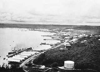
WBalikpapan Bay, is a bay in Indonesia, near Borneo island close to the city of Balikpapan, East Kalimantan, Indonesia. The Indonesian company Pertamina has its largest oil refinery on the eastern side of the bay.
 W
WThe Bohai Sea or Bo Sea, also known as Bohai Gulf, Bo Gulf or Pohai Bay, is a marginal sea approximately 78,000 km2 (30,000 sq mi) in area on the east coast of mainland China. It is the northwestern and innermost extension of the Yellow Sea, to which it connects to the east via the Bohai Strait.
 W
WThe Gulf of California is a marginal sea of the Pacific Ocean that separates the Baja California Peninsula from the Mexican mainland. It is bordered by the states of Baja California, Baja California Sur, Sonora, and Sinaloa with a coastline of approximately 4,000 km (2,500 mi). Rivers which flow into the Gulf of California include the Colorado, Fuerte, Mayo, Sinaloa, Sonora, and the Yaqui. The surface of the gulf is about 160,000 km2 (62,000 sq mi). Maximum depths exceed 3,000 meters (9,800 ft) because of the complex geology, linked to plate tectonics.
 W
WThe Gulf of Carpentaria is a large, shallow sea enclosed on three sides by northern Australia and bounded on the north by the eastern Arafura Sea. The northern boundary is generally defined as a line from Slade Point, Queensland in the northeast, to Cape Arnhem on the Gove Peninsula, Northern Territory in the west.
 W
WGulf of Corcovado is a large body of water separating the Chiloé Island from the mainland of Chile. Geologically, it is a forearc basin that has been carved out by Quaternary glaciers. Most of the islands of Chiloé Archipelago are located in the gulf. The area is next to the Chiloé National Park, and a large population of blue whales is found there, and it is under threat from salmon farming.
 W
WDavao Gulf is a gulf situated in the southeastern portion of Mindanao in the Philippines. It has an area of 308,000 hectares. Davao Gulf cuts into the island of Mindanao from Philippine Sea. It is surrounded by all five provinces in the Davao Region. The largest island in the gulf is Samal Island. Davao City, on the gulf's west coast, is the largest and busiest port on the gulf. The Bagobo, a tribe known in Davao, are living in the Davao Gulf.
 W
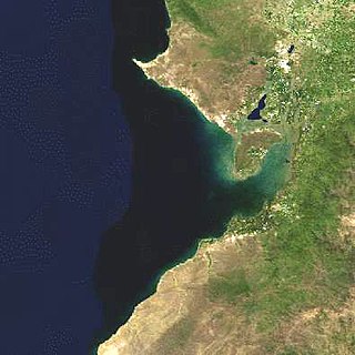
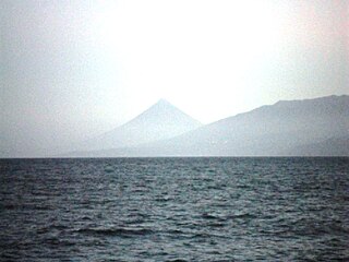
WGolfo Dulce is a gulf in Costa Rica, located at the South of the Province of Puntarenas. The inlet starts on the Pacific Ocean side of Costa Rica and extends slightly northward before turning west. The most westward part is at the city of Rincon. The bay separates the Osa Peninsula from the mainland Costa Rica.
 W
WThe Gulf of Fonseca, a part of the Pacific Ocean, is a gulf in Central America, bordering El Salvador, Honduras, and Nicaragua.
 W
WThe Gulf of Guayaquil is a large body of water of the Pacific Ocean in western South America. Its northern limit is the city of Santa Elena, in Ecuador, and its southern limit is Cabo Blanco, in Peru.
 W
WThe Gulf of Chiriquí is a part of Panama that encompasses Coiba National Park and Golfo de Chiriquí National Park. There are dozens of islands in this Gulf. Along with the islands of Coiba National Park there is also Islas Secas, Los Ladrones, Isla Parida, Isla Boca Brava, Isla Palenque and Isla Montuosa.
 W
WThe Gulf of Santa Catalina, also the Gulf of Catalina, is a gulf in the Pacific Ocean on the west coast of North America. The eastern coast of the gulf belongs to the states of California, United States, and Baja California, Mexico. The biggest town on the shore of the gulf is San Diego. The islands in the gulf include Santa Catalina Island. The gulf is over 100 square miles big and borders the east coast of Catalina and the beaches of Orange County, Los Angeles County, and San Diego county.
 W
WGulf of the Farallones is a gulf of the Pacific Ocean off the northern California coast. It extends westward from the opening of the San Francisco Bay and Drakes Bay to the Farallon Islands. Most of the gulf lies in Gulf of the Farallones National Marine Sanctuary, which protects about 1,250 square miles (3,200 km2).
 W
WHuon Gulf is a large gulf in eastern Papua New Guinea. It is bordered by Huon Peninsula in the north. Both are named after French explorer Jean-Michel Huon de Kermadec. Huon Gulf is a part of the Solomon Sea. Lae, capital of the Morobe Province is located on the northern coast of the gulf.
 W
WKaraginsky Gulf is a large gulf in the Bering Sea off the northeastern coast of Kamchatka (Russia), which cuts 117 km (73 mi) deep inland. The depth of the gulf is between 30 and 60 m. The largest island in the gulf is the Karaginsky Island, separated from the mainland by the Litke Strait. The Karaginsky Gulf is covered with ice from December until June.
 W
WLagonoy Gulf is a large gulf in the Bicol Peninsula of Luzon island in the Philippines. It is separated from the Philippine Sea by the Caramoan Peninsula in the north; and is separated from Albay Gulf in the south by a chain of islands including Batan Island and Rapu-rapu Island. It is about 3,070 square kilometres (1,190 sq mi) in area, with 80% of its area between 800 metres (2,600 ft) and 1,200 metres (3,900 ft) deep.
 W
WThe Lingayen Gulf is a large gulf on northwestern Luzon in the Philippines, stretching 56 km (35 mi). It is framed by the provinces of Pangasinan and La Union and sits between the Zambales Mountains and the Cordillera Central. The Agno River drains into Lingayen Gulf.
 W
WThe Gulf of Nicoya is an inlet of the Pacific Ocean. It separates the Nicoya Peninsula from the mainland of Costa Rica, and encompasses a marine and coastal landscape of wetlands, rocky islands and cliffs.
 W
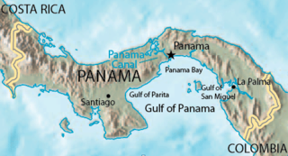
WThe Gulf of Panama is a gulf in the Pacific Ocean, near the southern coast of Panama. It has a maximum width of 250 kilometres (160 mi), a maximum depth of 220 metres (720 ft) and the size of 2,400 square kilometres (930 sq mi). The Panama Canal connects the Gulf of Panama with the Caribbean Sea and the Pacific Ocean. The Panamanian capital Panama City is the main urban centre on the gulf shore.
 W
WPanay Gulf is an extension of the Sulu Sea, reaching between the islands of Panay and Negros in the Philippines. The gulf contains the island-province of Guimaras and extends into the Santa Anna Bay between Panay and Guimaras and into Guimaras Strait, between Guimaras and Negros. Guimaras Strait connects Panay Gulf with the Visayan Sea.
 W
WThe Gulf of Papagayo is a large body of water off Guanacaste province and the northwestern coast of Costa Rica. The Gulf and its coastline are part of a major tourism project by Costa Rica's government. Among the most popular destinations on the Gulf of Papagayo are Ocotal Beach, Playas del Coco, Playa Hermosa, and Playa Panama. The Papagayo peninsula is the most developed area in the gulf region. The gulf waters are home to many wildlife including orcas.
 W
WThe Gulf of Papua is located in the southern coast region of New Guinea. With a total surface area of 70,400 km2 (27,200 sq mi).
WGulf of Parita or Parita Bay is a large gulf off the coast of Herrera Province, in Panama.
 W
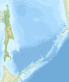
WGulf of Patience is a large body of water off the southeastern coast of Sakhalin, Russia.
 W
WThe Peter the Great Gulf is a gulf on the southern coast of Primorsky Krai, Russia, and the largest gulf of the Sea of Japan. The gulf extends for 185 km (115 mi) from the Russian-North Korean border at the mouth of the Tumen River in the west across to Cape Povorotny in the east, and its bays reach 90 km (56 mi) inland. Vladivostok, the largest city and capital of Primorsky Krai, and Nakhodka, the third largest city in the Krai, are located along the coast of the gulf.
 W
WRagay Gulf is a large gulf in the Bicol Peninsula of Luzon island in the Philippines, part of the Sibuyan Sea. It is separated from Tayabas Bay by the Bondoc Peninsula in the west. The gulf covers the provinces of Quezon and Camarines Sur.
 W
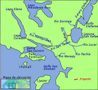
WThe Gulf of San Esteban is an embayment in Aysén Region in the Chilean part of Patagonia. The gulf forms a northeastern subembayment of the larger Gulf of Penas and to the northwest it bounds the Bay of San Quintín. The Gulf of San Esteban lies southwest of Forelius Peninsula, southwest of Isthmus of Ofqui and north of San Javier Island.
 W
WGulf of Tehuantepec is a large body of water on the Pacific coast of the Isthmus of Tehuantepec, southeastern Mexico, at 16°N 95°W. Many Pacific hurricanes form in or near this body of water. A strong, gale-force wind called the Tehuano periodically blows out over the waters of the Gulf of Tehuantepec, inducing strong upwelling of nutrient-rich waters which support abundant sea life.
 W
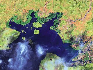
WThe Gulf of Thailand, also known as the Gulf of Siam, is a shallow northwesterny inlet in the southwestern South China Sea, bounded between the southwestern shores of the Indochinese Peninsula and the northern half of the Malay Peninsula. It is around 800 km (500 mi) in length and up to 560 km (350 mi) in width, and has a surface area of 320,000 km2 (120,000 sq mi). The gulf is surrounded on the north, west and southwest by the coastlines of Thailand, on the northeast by Cambodia and the Mekong Delta region of Vietnam, and opens to the South China Sea in the southeast.
 W
WThe Gulf of Tomini, also known as the Bay of Tomini, is the equatorial gulf which separates the Minahassa (Northern) and East Peninsulas of the island of Sulawesi (Celebes) in Indonesia. The Togian Islands lie near its center. To the east, the Gulf opens onto the Molucca Sea.
 W
WThe Gulf of Tonkin is a medium-sized gulf at the northwestern portion of the South China Sea, located off the coasts of northern Vietnam and South China. It is defined in the west and northwest by the northern coastline of Vietnam down to the Hòn La Island, in the north by China's Guangxi Zhuang Autonomous Region, and to the east by the Leizhou Peninsula and Hainan Island.