 W
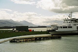
WApavatn is a lake in southwest Iceland. With a surface area of around 13 km² it is much larger than the neighbouring lake of Laugarvatn, which lies to the north of Apavatn.
 W
WAt 57 km², Blöndulón is one of Iceland's largest lakes. It was created in 1984-1991 as a reservoir for the Blönduvirkjun power plant, and has a depth of 39 m. It is situated near the Kjölur highland road in the Highlands of Iceland. The hot springs of Hveravellir are situated some 25 km to the south.
 W
WBreiðárlón is a glacier lake at the south end of the Icelandic glacier Vatnajökull.
 W
WFjallsárlón is a glacier lake at the south end of the Icelandic glacier Vatnajökull. Fjallsjökull which is part of the bigger glacier reaches down to the water of the lake and some ice-bergs are drifting by on its surface.
 W
WFrostastaðavatn is a lake in Iceland. It is situated in the Highlands of Iceland, not far from the famous mountains of Landmannalaugar and the volcano Hekla.
WGrænalón loosely translated as "Green-lagoon" was one of the glacial lakes of the Icelandic glacier Vatnajökull. It was situated in the south of Iceland. Its surface measured 18 km² during the 20th Century.
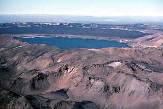
WGrímsvötn is a volcano with a fissure system located in Vatnajökull National Park, Iceland. The volcano itself is completely subglacial and located under the northwestern side of the Vatnajökull ice cap. The subglacial caldera is at 64°25′N 17°20′W, at an elevation of 1,725 m (5,659 ft). Beneath the caldera is the magma chamber of the Grímsvötn volcano.
 W
WHafravatn is a small lake on the eastern outskirts of Reykjavík, Iceland. Located at 76 m above sea level, it has an area of 1.02 km² with a greatest depth of 28 m. The Seljadalsa River flows into it from the east and its discharge is Ulfarsfellsa. A small village lies on the northern bank of the lake and a paragliding take-off point on its eastern side. The smaller lake of Langavatn lies to its southwest.
WHágöngulón is a lake in the Highlands of Iceland. It is 37 square kilometres (14 sq mi) in area and it is situated nearly 10 kilometres (6.2 mi) east of the Sprengisandur road, one of the highland tracks which cross Iceland from the south to the north, and a similar distance west of the largest glacier Vatnajökull. Immediately to the south is the lava field Hágönguhraun. It is fed by various streams consisting of meltwater from Vatnajökull and is drained by Kaldakvísl, a tributary of the Þjórsá, both of which flow in a southwest direction towards the southwest coast.
 W
WThe Hálslón Reservoir is a storage reservoir in Eastern Iceland on the Jökulsá á Dal River. The reservoir stores water for use in hydroelectricity production with the Kárahnjúkar Hydropower Plant. The reservoir was formed by three different concrete-faced, rock-filled embankment dams: the Kárahnjúkastífla Dam, the Desjarárstífla Dam and the Sauðárdalsstífla Dam.
 W
WHöfðavatn is a lagoon-like lake in northern Iceland. It is located in the municipality of Skagafjörður.
WHoltsós, sometimes anglicised as Holtsos, is a tidal lagoon south of Eyjafjallajökull in south Iceland. It is fed by the Holtsá river and separated from the Atlantic Ocean by a narrow strip of sand. It is approximately 4 kilometres (2.5 mi) long by 2 kilometres (1.2 mi) wide and approximately 2 metres (6.6 ft) deep at its deepest point.
 W
WHreðavatn is a lake in the west of Iceland. It is situated near Route 1 between Borgarnes and the pass of Holtavörtuheiði. Nearby is the university faculty of Bifröst and the Grábrók craters as well as the mountain Baula.
 W
WThe lake Hvalvatn is situated some kilometers to the east of Hvalfjörður in the western portion of Iceland. It lies to the east of the tuya Hvalfell. The surface measures 4.1 km2 (1.6 sq mi), and its greatest depth is 180 m (590 ft).
WHvítárvatn is a lake in the Highlands of Iceland and the source of the glacial river Hvítá, Árnessýsla. It is located 45 km northeast of Gullfoss waterfall. Its surface is about 30 km² and its greatest depth is 84 m.
WHvítavatn is a small lake in the southern Highlands of Iceland. It is situated between Sídujökull and Skeiðarájökull, two of the southern arms of the big glacier Vatnajökull, and lies 15 km to the north of the infamous Skeiðará sander.
 W
WJökulsárlón is a large glacial lake in southern part of Vatnajökull National Park, Iceland. Situated at the head of the Breiðamerkurjökull glacier, it developed into a lake after the glacier started receding from the edge of the Atlantic Ocean. The lake has grown since then at varying rates because of melting of the glaciers. It is now 1.5 km (0.93 mi) away from the ocean's edge and covers an area of about 18 km2 (6.9 sq mi). In 2009 it was reported to be the deepest lake in Iceland, at over 284 m (932 ft), as glacial retreat extended its boundaries. The size of the lake has increased fourfold since the 1970s.
 W
WKleifarvatn is the largest lake on the Reykjanes Peninsula in Iceland, situated in the southern part of the peninsula. It is located on the fissure zone of the Mid-Atlantic Ridge. The lake has no visible water coming in or going out as most of its water comes and leaves underground. The lake can be reached via a track, and there are two areas with high temperature that can be found not far from it: Seltún/Krýsuvík and another to the east. The lake's greatest depth is 97 m. After the 2000 Iceland earthquakes, the lake began to diminish, and 20% of its surface has since disappeared.
WKvíslavatn is a lake in Iceland. The lake is situated in the Highlands of Iceland to the west of Sprengisandur highland road and to the south-east of the glacier Hofsjökull. Its surface area is about 20 km².
 W
WLagarfljót is a lake situated in the east of Iceland near Egilsstaðir. Its surface measures 53 square kilometres (20 sq mi) and it is 25 kilometres (16 mi) long; its greatest width is 2.5 km (1.6 mi) and its greatest depth 112 m (367 ft). The River Lagarfljót flows through this lake. The 27 MW Lagarfossvirkjun hydropower station is located at its lower end.
 W
WLangisjór is a lake in the western part of Vatnajökull National Park, Iceland. It is around 20 km in length and up to 2 km wide, with a total surface area of about 26 km2 (10 sq mi) and a depth of 75m at its deepest point.
 W
WLaugarvatn is the name of a lake and a small town in the south of Iceland. The lake is smaller than the neighbouring Apavatn.
WLeirvogsvatn is a small lake, located about 23 kilometres (14 mi) northeast of Reykjavík, Iceland. It lies along Route 36. Located at 211 metres (692 ft) above sea level, it has an area of 1.2 square kilometres (0.46 sq mi) with a maximum depth of 16 metres (52 ft). Fed by the Leirvogsvatn River, the lake is the subject of a legend in the form of a horse-shaped monster. The lake is known to contain populations of Gasterosteus islandicus.
WMývatn is a shallow lake situated in an area of active volcanism in the north of Iceland, not far from Krafla volcano. It has a high amount of biological activity. The lake and the surrounding wetlands provides a habitat for a number of waterbirds, especially ducks. The lake was created by a large basaltic lava eruption 2300 years ago, and the surrounding landscape is dominated by volcanic landforms, including lava pillars and rootless vents (pseudocraters). The effluent river Laxá is known for its rich fishing for brown trout and Atlantic salmon.
WNyrðra-Vatnalautavatn is the largest body of water on Ófeigsfjarðarheiði in Iceland.
 W
WÖskjuvatn is a lake in the Highlands of Iceland. Its surface area is about 11 km². With a depth of 217 m (712 ft), it is the second deepest lake in Iceland after Jökulsárlón.
 W
WThe lake Sigöldulón is a reservoir in Iceland, also known as Krókslón. Situated in the south of the country, not far from Landmannalaugar, it is one of the country's 20 largest lakes at 14 km².
 W
WSkorradalsvatn is a lake in the west of Iceland. It is situated in a narrow valley between the Hvalfjörður and the valley Reykholtsdalur. Its length is about 15 km.
WThe lake Sultartangarlón is situated in the Highlands of Iceland to the north of the volcano Hekla. It is a reservoir of the river Þjórsá. Its surface area is 20 km².
WThere are three lakes of the name Svínavatn in Iceland.
 W
WÞingvallavatn, anglicised as Thingvallavatn, is a rift valley lake in southwestern Iceland. With a surface of 84 km² it is the largest natural lake in Iceland. Its greatest depth is 114 m. At the northern shore of the lake, at Þingvellir, the Alþingi, the national parliament, was founded in the year 930, and held its sessions there until 1799 and still as of today the name Alþingi Íslendinga is carried by the parliament of Iceland.
WÞórisvatn is the largest lake of Iceland, situated at the south end of Sprengisandur highland road within the highlands of Iceland.
 W
WÚlfljótsvatn is a lake in southern Iceland, to the south of lake Þingvallavatn, 74km east of Reykjavík. Úlfljótsvatn is named after Úlfljótur, an important man who was involved in the Althingi in 930.