 W
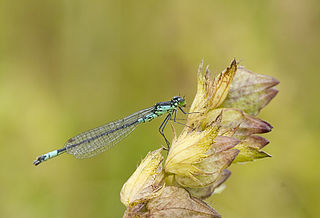
WAeshna isoceles is a small hawker dragonfly that is found in Europe, mostly around the Mediterranean, and the lowlands of North Africa. Its common name in English is green-eyed hawker. In Britain it is a rare and local species and is known as the Norfolk hawker. It has a brown colour with green eyes and clear wings and also a yellow triangular mark on the second abdominal segment which gave rise to its scientific name. It used to be in the genus Anaciaeschna as it has several differences from the other members of the genus Aeshna. Its specific name is often spelt isosceles.
 W
WAlbion is a Norfolk wherry. Built in 1898, she served as a trading vessel and then as a lighter, until being acquired by the Norfolk Wherry Trust for restoration and preservation in 1949. Since 1981 she has been moored at the Norfolk Wherry Trust wherry base at Womack Water near Ludham. She is listed on the register of National Historic Ships in the United Kingdom as part of the National Historic Fleet.
 W
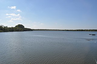
WBreydon Water is a 514.4-hectare (1,271-acre) biological Site of Special Scientific Interest at Great Yarmouth, Norfolk. It is a Local Nature Reserve, a Ramsar site and a Special Protection Area. It is part of the Berney Marshes and Breydon Water nature reserve, which is managed by the Royal Society for the Protection of Birds (RSPB).
 W
WBure Marshes National Nature Reserve (NNR) is maintained by English Nature in Norfolk, England, within The Broads National Park.
 W
WThe River Bure is a river in the county of Norfolk, England, most of it in the Broads. The Bure rises near Melton Constable, 11 miles (18 km) upstream of Aylsham, which was the original head of navigation. Nowadays, the head of navigation is 10 miles (16 km) downstream at Coltishall Bridge. After Aylsham Lock and Burgh Bridge, the Bure passes through Buxton Lammas, Coltishall, Belaugh, Wroxham, Horning, Ludham Bridge, past St. Benet's Abbey, through Oby, Acle, Stokesby, along the northern border of the Halvergate Marshes, through Runham and Great Yarmouth where it meets Breydon Water and flows into the sea at Gorleston.
 W
WCalthorpe Broad is a 43.5-hectare (107-acre) biological Site of Special Scientific Interest east of Stalham in Norfolk. It is a Nature Conservation Review site, Grade I and a National Nature Reserve. It is also part of the Broadland Ramsar site and Special Protection Area, and The Broads Special Area of Conservation.
 W
WThe River Chet is a small river in South Norfolk, England, a tributary of the River Yare. It rises in Poringland and flows eastwards through Alpington, Bergh Apton, Thurton and Loddon. At Loddon it passes under the A146 through Loddon Mill and into Loddon Staithe. From this point onwards the river is navigable. It then passes Hardley Flood to the north, a nature reserve part-managed by the Norfolk Wildlife Trust. The river finally joins the River Yare one mile west of Reedham at Hardley Cross, erected in 1676, which marks the ancient boundary between the City of Norwich and the Borough of Great Yarmouth. The total navigable length is some 3½ miles. Fishing is permitted between Loddon and Hardley Cross, bream and roach being the most common catch.
 W
WClippesby is a small village in Eastern England within the Great Yarmouth Borough Council area, Norfolk; located on the B1152 and surrounded by the Norfolk Broads. The village consists largely of a few rows of small cottages and houses with four buildings of historical relevance, the Church of St. Peter's, the Rectory, the Old Hall and Clippesby Hall. It is surrounded by outlying farmsteads. Farming and tourism comprise the majority of its economy, the latter being based in the grounds of Clippesby Hall. The population of the village is included in the civil parish of Fleggburgh.
 W
WCrome's Broad is situated to the east of the River Ant, north of How Hill, within The Broads National Park in Norfolk, England.
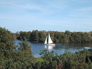
WFilby Broad is one of five broads (lakes) in the Trinity Broads in Norfolk, England. It lies within the Broads National Park, adjacent to the village of Filby. The broad has an abundant selection of birds and wildlife.
 W
WThe Haddiscoe Cut or New Cut is a canal in the English county of Norfolk and in The Broads. The cut was conceived as a way to provide a more direct route from Lowestoft to Norwich, and was built as part of a larger scheme which included the linking of the River Waveney to Oulton Broad and Lake Lothing. It was opened in 1833, but the new route was not a financial success, and it was sold to a railway developer in 1842. It remained in railway ownership until Nationalisation in 1948, and was damaged by floods in 1953. An attempt to close it in 1954 was resisted by local interests, resulting in it being repaired. It is now managed by the Environment Agency.
 W
WThe Halvergate Marshes are an area of grazing marsh in the east of the English county of Norfolk. They form part of the area of The Broads and lie between the River Bure and the River Yare, bordering Breydon Water on the east. The marshes cover an area of around 2,642 hectares An area of 1,432.7-hectare (3,540-acre) is a biological Site of Special Scientific Interest. Some areas are also in the Breydon Water Local Nature Reserve, the Broadland and Breydon Water Ramsar sites, The Broads Special Area of Conservation, and The Broads and Breydon Water Special Protection Areas.
 W
WHathor (1905) is one of only six surviving Norfolk pleasure wherries to be found on the Norfolk Broads. Like two of the other surviving wherries, Maud and Solace, she was built by D. S. Halls of Reedham. Hathor has been listed on the register of National Historic Ships in the United Kingdom since 1996 and is part of the National Historic Fleet.
 W
WHickling Broad is a 600-hectare (1,500-acre) nature reserve 4 km south-east of Stalham, north-east of Norwich in Norfolk. It is managed by the Norfolk Wildlife Trust. It is a National Nature Reserve and part of the Upper Thurne Broads and Marshes Site of Special Scientific Interest and Hickling Broad and Horsey Mere Nature Conservation Review site, Grade I. It is in the Norfolk Coast Area of Outstanding Natural Beauty, and part of the Broadland Ramsar site and Special Protection Area, and The Broads Special Area of Conservation.
WHorning is an ancient village and parish in the English county of Norfolk. It covers an area of 11 km2 and had a population of 1,033 in the 2001 census. Horning parish lies on the northern bank of the River Bure south of the River Thurne and is located in The Broads National Park. For the purposes of local government, it falls within the district of North Norfolk, although areas alongside the rivers and broads fall into the executive area of the Broads Authority.
WHorsey Mere is one of the Norfolk Broads in the east of England; it is one of the more northerly broads close to the North Sea coast.
WHoveton Great Broad lies within The Broads in Norfolk, England, between Wroxham Broad and Salhouse Broad.
 W
WHow Hill lies on the River Ant within The Broads National Park in Ludham, Norfolk, England.
 W
WMalthouse Broad is a broad at Ranworth in the Norfolk Broads.
 W
WMaud, along with Albion, is one of only two surviving Norfolk trading wherries to be found on the Norfolk Broads. Maud was built in 1899, and served as a sailing wherry and later as a lighter before being sunk in the mid-1960s as protection for part of the banks of Ranworth Broad. In 1981, she was refloated and taken to Upton where she was restored over a number of years, finally returning to the water in 1999. As of 2010, Maud is active on the Norfolk Broads. She is listed on the register of National Historic Ships in the United Kingdom, as part of the National Historic Fleet.
 W
WNeatishead is a village and civil parish in the English county of Norfolk. The village is situated some 20 km (12 mi) north-east of the city of Norwich, within The Norfolk Broads and to the west of Barton Broad. Access to Neatishead from the broad is by way of Limekiln Dyke, a narrow channel leading off the broad.
 W
WNorfolk damselfly or dark bluet is a species of blue damselfly of the family Coenagrionidae. This species acquired its common name from its discovery in 1903 and presence in a very restricted area of the Norfolk Broads. Records came from Sutton, Stalham, and Hickling Broads.
 W
WThe Norfolk wherry is a type of boat used on The Broads in Norfolk and Suffolk, England. Three main types were developed over its life, all featuring the distinctive gaff rig with a single, high-peaked sail and the mast stepped well forward.
 W
WPotter Heigham is a village and civil parish on the River Thurne in the English county of Norfolk. It is situated 12 mi (19 km) north-east of the city of Norwich on the A149 road, and within the Broads.
 W
WRanworth Broad is a 136-hectare (340-acre) nature reserve on the Norfolk Broads north-east of Norwich in Norfolk, United Kingdom. It is managed by the Norfolk Wildlife Trust. it is part of Bure Broads and Marshes Site of Special Scientific Interest and Bure Marshes Nature Conservation Review site, Grade I. and National Nature Reverse It is also part of the Broadland Ramsar site and Special Protection Area, and The Broads Special Area of Conservation.
 W
WThe River Thurne is a river in Norfolk, England in The Broads. Just 7 miles (11 km) long, it rises 2 miles (3.2 km) from the coast near Martham Broad and is navigable from West Somerton. It flows southwest and is linked by Candle Dyke and Heigham Sound to both Horsey Mere and Hickling Broad. It continues southwest and flows through Potter Heigham and enters the River Bure just south of Thurne dyke, near St Benet's Abbey.
 W
WThe River Yare is a river in the English county of Norfolk. In its lower reaches it is one of the principal navigable waterways of The Broads and connects with the rest of the network.
 W
WRockland Broad is an area of open water, known as a broad, located north east of the village of Rockland St. Mary in the English county of Norfolk. The broad is in the Broads protected area. It comprises an area of approximately 50 acres (200,000 m2) and is surrounded by marshland and tall reed beds. It is linked to the River Yare by two dykes, the Short Dyke and the Fleet Dyke.
 W
WSalhouse Broad, one of the Norfolk Broads, is situated on the River Bure in The Broads in Norfolk, England.
 W
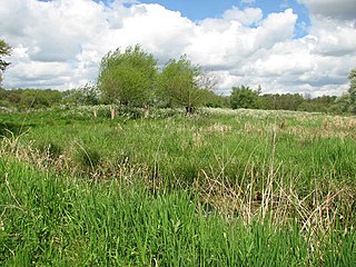
WSurlingham Church Marsh is a small RSPB nature reserve in the Norfolk Broads, England. It is part of Yare Broads and Marshes Site of Special Scientific Interest
 W
WTrinity Broads is a 316.8-hectare (783-acre) biological Site of Special Scientific Interest north of Great Yarmouth in Norfolk. They are in The Broads Special Area of Conservation. They are also part of the Broads National Park in Norfolk, England, comprising 5 broads in total. The three largest are Rollesby Broad, Ormesby Broad and Filby Broad, and there are two much smaller broads named Lily Broad and Ormesby Little Broad. They are managed by the Broads Authority.
 W
WThe River Waveney is a river which forms the boundary between Suffolk and Norfolk, England, for much of its length within The Broads.
 W
WWroxham Broad is an area of open water alongside the River Bure near the village of Wroxham in Norfolk, England within The Broads National Park. The Norfolk Broads were formed by the flooding of ancient peat workings. Wroxham Broad has an area of 34.4 hectares and a mean depth of 1.3 metres. It lies to the west of the Bure, with two navigable openings between river and broad. The village and broad lie in an area of fairly intensive agriculture, with areas of wet woodland adjoining the broad and river.