 W
WCitizen Potawatomi Nation is a federally recognized tribe of Potawatomi people located in Oklahoma. The Potawatomi are traditionally an Algonquian-speaking Eastern Woodlands tribe. They have 29,155 enrolled tribal members, of whom 10,312 live in the state of Oklahoma.
 W
WThe Potawatomi, also spelled Pottawatomi and Pottawatomie, are a Native American people of the Great Plains, upper Mississippi River, and western Great Lakes region. They traditionally speak the Potawatomi language, a member of the Algonquin family. The Potawatomi call themselves Neshnabé, a cognate of the word Anishinaabe. The Potawatomi are part of a long-term alliance, called the Council of Three Fires, with the Ojibway and Odawa (Ottawa). In the Council of Three Fires, the Potawatomi are considered the "youngest brother" and are referred to in this context as Bodéwadmi, a name that means "keepers of the fire" and refers to the council fire of three peoples.
 W
WThe Anishinaabe are a group of culturally-related Indigenous peoples resident in what are now Canada and the United States. They also include the Odawa, Saulteaux, Ojibwe, Potawatomi, Oji-Cree, and Algonquin peoples. The Anishinaabe speak Anishinaabemowin, or Anishinaabe languages that belong to the Algonquian language family. They historically lived in the Northeast Woodlands and Subarctic.
 W
WAnishinaabe traditional beliefs cover the traditional belief system of the Anishinaabeg peoples, consisting of the Algonquin/Nipissing, Ojibwa/Chippewa/Saulteaux/Mississaugas, Odawa, Potawatomi and Oji-Cree, located primarily in the Great Lakes region of North America.
CHRZ-FM is a Canadian radio station, broadcasting at 91.3 FM in Wasauksing, Ontario near Parry Sound. Branded as Rez 91, the station airs a First Nations community radio format.
 W
WThe Dumaw Creek Site is an archaeological site designated 20OA5, located along Dumaw Creek northeast of Pentwater, Michigan, that was the location of a 17th-century village and cemetery. It is one of the youngest pre-historic sites in Michigan, dating to the terminal Late Woodland Period just prior to European contact. It was listed on the National Register of Historic Places in 1972.
 W
WThe Gun Lake Trust Land Reaffirmation Act is an act of Congress that reaffirmed the status of lands taken into trust by the Department of the Interior (DOI) for the benefit of the Match-E-Be-Nash-She-Wish Band of Pottawatomi Indians in the state of Michigan.
 W
WThe Hannahville Indian Community is a federally recognized Potawatomi tribe residing in Michigan's Upper Peninsula, approximately 15 miles (24 km) west of Escanaba on a 8.5755-square-mile (22.210 km2) reservation. The reservation, at 45°46′59″N 87°25′23″W, lies mostly in Harris Township in eastern Menominee County, but a small part is located in northeastern Gourley Township, also in Menominee County, and another in Bark River Township in adjacent southwestern Delta County.
 W
WThe Hoxie Farm Site (11Ck-4) is located on Thorn Creek in Calumet City in Cook County, Illinois, near the city of Chicago. It is classified as a late Prehistoric to Protohistoric/Early Historic site with Upper Mississippian Huber affiliation.
WThe Huber Site (11Ck-1) is located on Tinley Creek 2 miles west of Blue Island in Cook County, Illinois, near the city of Chicago. It is classified as a late Prehistoric site with Upper Mississippian affiliation.
 W
WIndian Boundary Park is a 13-acre (5.3 ha) urban park in the West Ridge neighborhood of North Side, Chicago, Illinois.
 W
WIndian removals in Indiana followed a series of the land cession treaties made between 1795 and 1846 that led to the removal of most of the native tribes from Indiana. Some of the removals occurred prior to 1830, but most took place between 1830 and 1846. The Lenape (Delaware), Piankashaw, Kickapoo, Wea, and Shawnee were removed in the 1820s and 1830s, but the Potawatomi and Miami removals in the 1830s and 1840s were more gradual and incomplete, and not all of Indiana's Native Americans voluntarily left the state. The most well-known resistance effort in Indiana was the forced removal of Chief Menominee and his Yellow River band of Potawatomi in what became known as the Potawatomi Trail of Death in 1838, in which 859 Potawatomi were removed to Kansas and at least forty died on the journey west. The Miami were the last to be removed from Indiana, but tribal leaders delayed the process until 1846. Many of the Miami were permitted to remain on land allotments guaranteed to them under the Treaty of St. Mary's (1818) and subsequent treaties.
 W
WLake James is a natural lake located in the northeast corner of the state of Indiana in the United States. It is popular as a place for boating and fishing, and has a wide variety of wildlife. As the state's fourth largest natural lake, it has over 1,200 acres (490 ha) of surface water, and consists of three basins. Its water quality is ranked among the best in Indiana lakes. The lake is the largest of a group of lakes known as the James Lake Chain. These lakes are located mostly in Steuben County, Indiana, but also extend into southern Michigan.
 W
WLake Maxinkuckee is the second largest natural lake in the U.S. state of Indiana, covering 1,864 acres (8 km2). The Town of Culver, Indiana, in southwestern Marshall County is located on its northwestern edge. Lake Maxinkuckee has a maximum depth of 88 feet and an average depth of 24 feet. Local residents and visitors do many things including ice fishing on the lake.
 W
WDuring the first half of the 19th century, several treaties were concluded between the United States of America and the Native American tribe of the Potawatomi. These treaties concerned the cession of lands by the tribe, and were part of a large-scale effort by the United States government to purchase and thereby extinguish their claims in the Northwest Territory and the Southeast, and to remove all such indigenous peoples to lands west of the Mississippi River.
 W
WThe Michigan Heritage Park was an open-air museum that spanned 10,000 years of Michigan history. It consisted of a half-mile trail loop that started with a pre-historic mastodon exhibit and ended at a Civilian Conservation Corps camp exhibit. The historical exhibits are recreations. The park was operated by Muskegon's Lakeshore Museum Center.
 W
WThe Moccasin Bluff Site is an archaeological site located along Red Bud Trail and the St. Joseph River north of Buchanan, Michigan. It was listed on the National Register of Historic Places in 1977, and has been classified as a multi-component Prehistoric site with the major component dating to the Late Woodland/Upper Mississippian period.
WThe Oak Forest Site (11Ck-53) is located in Oak Forest, Cook County, Illinois, near the city of Chicago. It is classified as a late Prehistoric to Protohistoric/Early Historic site with Upper Mississippian Huber affiliation.
 W
WOjibwe, also known as Ojibwa, Ojibway or Otchipwe, is an indigenous language of North America of the Algonquian language family. The language is characterized by a series of dialects that have local names and frequently local writing systems. There is no single dialect that is considered the most prestigious or most prominent, and no standard writing system that covers all dialects.
 W
WThe Otter Spring House is a historic spring house in the Town of Lincoln in Forest County, Wisconsin. The spring house was built on Otter Spring in 1933 as a Civilian Conservation Corps project. It was originally built to supply water to the CCC's Waubikon Lake Camp but was insufficient for that purpose. Since its construction, the Potawatomi have used the spring house for ceremonial and religious purposes. Potawatomi ritual feasts must use spring water, as springs are considered "living waters"; when taking water from the spring, the Potawatomi offer a thanksgiving prayer and a tobacco offering. The spring house was added to the National Register of Historic Places on June 3, 1999.
 W
WThe Pine Creek Indian Reservation is the home of the Nottawaseppi Huron Band of Potawatomi (NHBP), a federally-recognized tribe of Potawatomi in the United States. The reservation headquarters is located at 1485 Mno-Bmadzewen Way, between Fulton, Michigan and Athens, Michigan. The historic structures on the reservation were listed on the National Register of Historic Places in 1973.
Pokagon Band of Potawatomi Indians are a federally recognized Potawatomi-speaking tribe based in southwestern Michigan and northeastern Indiana. Tribal government functions are located in Dowagiac, Michigan. They occupy reservation lands in a total of ten counties in the area.
 W
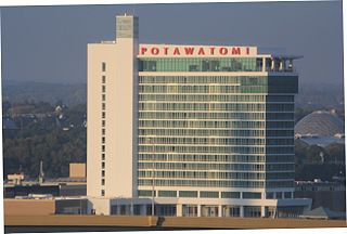
WPotawatomi Hotel & Casino, formerly Potawatomi Bingo Casino, is a Native American casino in Milwaukee, Wisconsin, owned and operated by the Forest County Potawatomi Community. It first opened its doors March 7, 1991. Located on Canal Street in the Menomonee Valley near Downtown Milwaukee, this entertainment destination offers a variety of entertainment options, including a 20-table poker room, multiple restaurants and dining options, a food court, the Northern Lights Theater, the Sky Lodge, and a 500-seat two-tiered theater that combines entertainment and dining. It's a popular destination spot for visitors outside of Milwaukee.
 W
WThe Potawatomi Trail of Death was the forced removal by militia in 1838 of some 859 members of the Potawatomi nation from Indiana to reservation lands in what is now eastern Kansas. The march began at Twin Lakes, Indiana on September 4, 1838, and ended on November 4, 1838, along the western bank of the Osage River, near present-day Osawatomie, Kansas. During the journey of approximately 660 miles (1,060 km) over 61 days, more than 40 persons died, most of them children. It marked the single largest Indian removal in Indiana history.
 W
WPottawatomie Indian Pay Station is a historic building in St. Marys, Kansas and associated with the Pottawatomie tribe.
 W
WPrairie Band Potawatomi Nation is a federally recognized tribe of Neshnabé, headquartered near Mayetta, Kansas.
 W
WThe Prairie Band Potawatomi Indian Reservation is an Indian reservation for the Prairie Band Potawatomi Nation located in Jackson County, Kansas. The Potawatomi used to be located in the Great Lakes area, but were forced to move west due to Europeans settling their land. The reservation encompasses all of Lincoln Township, plus parts of Banner Township, Franklin Township, and Grant Township.
WThe Rock Island II site is located on the south side of Rock Island, in Door County, Wisconsin, United States, at the mouth of Green Bay, within the boundaries of Rock Island State Park. It is classified as an Early Historic site with occupations by the Potawatomi, Huron, Petun, Ottawa and Wyandot tribes.
 W
WSt. Mary's Mission was a Jesuit mission founded in 1847 along the Oregon Trail. The Pottawatomie Indian Pay Station was built in 1855 for use by government agents to pay an annuity to the Pottawatomie Indians who relocated to the area from the Great Lakes region. The city of St. Marys, Kansas was established around the mission. During the 19th and 20th centuries Native American children were often forced to attend Mission schools like St. Mary's. Potawatomi children were taken from their families in the 1860s and sent to St. Mary's Mission where they were left in the care of White Americans.
WThe Treaty of Fort Wayne was a treaty between the United States and several groups of Native Americans. The treaty was signed on June 7, 1803 and proclaimed December 26, 1803. It more precisely defined the boundaries of the Vincennes tract ceded to the United States by the Treaty of Greenville, 1795.
WThe Treaty of Tippecanoe was an agreement between the United States government and Native American Potawatomi tribes in Indiana on October 26, 1832.
 W
WGeorge Winter was an English-born landscape and portrait artist who immigrated to the United States in 1830 and became an American citizen in northern Indiana's Wabash River valley. Winter was one of Indiana's first professional artists. In addition, he is considered the state's most significant painter of the first half of the nineteenth century. Winter is especially noted for his sketches, watercolors, and oil portraits that provide a visual record of the Potawatomi and Miami people in northern Indiana from 1837 to the 1840s, as well as other figures drawn from his firsthand observations on the American frontier.
 W
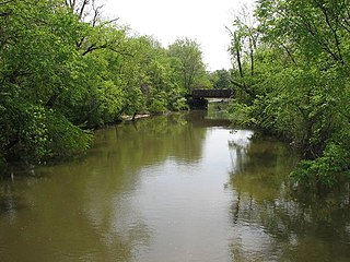
WThe Yellow River is a 62.3-mile-long (100.3 km) tributary of the Kankakee River in the Central Corn Belt Plains ecoregion, located in northern Indiana in the United States. Via the Kankakee and Illinois rivers, it is part of the watershed of the Mississippi River, draining an area of 427 square miles (1,110 km2). The river's name possibly derives from a translation of the Shawnee name for the river, We-thau-ka-mik, meaning "yellow waters", a description perhaps owing to the presence of sand in the riverbed.