 W
WSai Kung Peninsula is a peninsula in the easternmost part of the New Territories in Hong Kong. Its name comes from Sai Kung Town in the central southern area of the peninsula. The southern part of the peninsula is administrated by Sai Kung District, the north by Tai Po District and the northwest by Sha Tin District.
 W
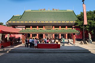
WChe Kung Miu, also called Che Kung Temple, are temples dedicated to Che Kung, who was a general during the Southern Song Dynasty (1127–1279) in ancient China. He is believed by some worshipers to have been involved in the attempt to keep the Song state alive by bringing Prince Ping and his brother to the South. There are two temples dedicated to Che Kung in Hong Kong: one in Sha Tin and one in Ho Chung. Other temples in Hong Kong are partly dedicated to Che Kung.
 W
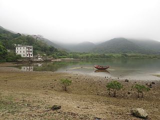
WChek Keng is an area and village of Hong Kong. Located within Sai Kung East Country Park, on the northern coast of Sai Kung Peninsula and facing Long Harbour, it is administratively part of Tai Po District.
 W
WHam Tin or Ham Tin Tsuen is a village facing Ham Tin Wan, one of the four main bays of Tai Long Wan, in the Sai Kung District of Hong Kong.
 W
WHigh Island or Leung Shuen Wan Chau is a former island in the southeast of Sai Kung Peninsula, Hong Kong.
 W
WThe High Island Reservoir, located in the far south eastern part of the Sai Kung Peninsula, was opened in 1978 helping to alleviate water shortage problems in Hong Kong. Its water capacity is approximately 273 million cubic metres. The area it occupies was originally the Kwun Mun Channel (官門海峽), which separated High Island from the Sai Kung Peninsula.
 W
WHo Chung is a village on the Sai Kung Peninsula in Hong Kong. The Ho Chung River (蠔涌河) runs through the village.
 W
WHoi Ha is a place and a village on the innermost shore of Hoi Ha Wan, Hong Kong. It is at the north of Pak Sha O in the Sai Kung Peninsula.
WHoi Ha Wan or Jone's Cove is a bay at the north of Sai Kung Peninsula. It is part of Hoi Ha Wan Marine Park, a marine park in Hong Kong. The village of Hoi Ha is located on the innermost shore of Hoi Ha Wan.
 W
WKei Ling Ha is an area of Shap Sze Heung, on the Sai Kung Peninsula, in eastern New Territories of Hong Kong. Administratively, it is part of Tai Po District. It is a popular place for countryside visits, picnicking and bird watching.
 W
WKo Lau Wan is a remote village in the north of Sai Kung Peninsula, Hong Kong. Administratively, it is under the jurisdiction of Tai Po District.
 W
WLai Chi Chong is a village and an area of Hong Kong, located on the southeastern shore of Tolo Channel, and on the northern shore of the Sai Kung Peninsula, in the Eastern New Territories. Administratively, it is part of Tai Po District.
 W
WLong Harbour, also known as Tai Tan Hoi, is a natural harbour formed from an inlet of Mirs Bay to the north of Sai Kung Peninsula, Hong Kong.
 W
WLong Ke Wan is a bay in Sai Kung District, Hong Kong.
 W
WPak Kong is a village in Sai Kung Peninsula, Hong Kong.
 W
WPak Tam Au is an area within the Sai Kung East Country Park, on the Sai Kung Peninsula in the New Territories of Hong Kong. It is administratively under the Tai Po District.
 W
WPak Tam Chung is an area in the southern part of the Sai Kung Peninsula in the New Territories of Hong Kong. It is administratively under the Sai Kung District.
 W
WRocky Harbour or Leung Shuen Wan Hoi is a harbour at the south-east of Sai Kung Peninsula, Hong Kong.
 W
WSai Kung East Country Park is a 44.77 square kilometres (17.29 sq mi) country park on the Sai Kung Peninsula in Hong Kong. It opened in 1978 and has features including:High Island Reservoir High Island Pak Tam Au Sheung Yiu Wong Shek Pier Beaches of Tai Long Wan: Sai Wan, Ham Tin Wan, Tai Wan and Tung Wan. Sharp Peak Po Pin Chau Conic Island Long Ke Wan Luk Wu Long Harbour Chek Keng
 W
WSai Kung Islands is one of the 29 constituencies in the Sai Kung District.
 W
WSai Kung North is one of the 19 constituencies in the Tai Po District. The constituency returns one district councillor to the Tai Po District Council, with an election every four years.
 W
WSha Kok Mei is a village in Sai Kung Peninsula, Hong Kong.
 W
WSham Chung is a village and an area of Neolithic settlement in Hong Kong. It is located near Wong Tei Tung beside Three Fathoms Cove on the Sai Kung Peninsula.
 W
WSharp Peak also known as Nam She Tsim, is a hill which lies within the Sai Kung East Country Park, north of Tai Long Wan, in the Sai Kung Peninsula in Hong Kong. It is particularly well known for its well-defined sharp peak, which rises to a height of 468 metres (1,535 ft) above sea level. The hill is reasonably hard for hikers and should only be attempted in good weather with correct equipment, although it is a popular site for hiking in Hong Kong.
 W
WSheung Yiu Folk Museum is housed in Sheung Yiu Village, a declared monument of Hong Kong, on Pak Tam Chung Nature Trail, Sai Kung District, Hong Kong. Sheung Yiu means "above the kiln" in Chinese.
 W
WSai Wan is a beach in Sai Kung Peninsula, Hong Kong. To distinguish it from other bays and beaches of the same name, it is commonly known as Tai Long Sai Wan, as it is one of the four main beaches of Tai Long Wan. It came first in the Hong Kong Best 10 Scenic Sites Election in 2006.
 W
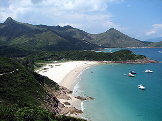
WTai Long Wan is a 3 kilometer-wide bay on the east coast of the Sai Kung Peninsula in Sai Kung District, Hong Kong. Considered one of the most beautiful places in Hong Kong, it is a popular surf destination.
 W
WTai Mun Shan lies to the west of Tai Long Wan near Chek King on the Sai Kung Peninsula in Hong Kong. The hill comprises a rounded peak, which rises to a height 370 metres.
 W
WTsam Chuk Wan is a bay of the Sai Kung Peninsula in Hong Kong. By extension, it is also the name of the area around the bay. Tsam Chuk Wan Village (斬竹灣村) is one of the villages located within this area.
 W
WWan Tsai is a peninsula at the northern extremity of the north-western Sai Kung Peninsula, Hong Kong, with Hoi Ha Wan to its west and Long Harbour on its east. Grass Island lies east of the peninsula.
 W
WWong Keng Tei is a village in Tsam Chuk Wan, Sai Kung Peninsula, Hong Kong.
 W
WWong Shek, or Wong Ma Tei, is an area in the northern part of the Sai Kung Peninsula in Hong Kong. It is under the administration of Tai Po District. In the area, there are picnic facilities with views of the sea. However, to protect the natural environment of Wong Shek, the Government controls the number of vehicle entering the area; a gate is set up at Pak Tam Chung on the way towards Wong Shek, which only allows permitted vehicles to enter. There is also a public pier called "Wong Shek Pier".
WWong Shek Pier is a public pier on the shore of Long Harbour (赤徑海) in the north-east of Hong Kong's New Territories. It is situated in the Wong Shek (黃石) area of the Sai Kung Peninsula. Administratively it is in Tai Po District.