 W
WThe Gunnison National Forest is a U.S. National Forest covering 1,672,136 acres in Mesa, Gunnison, Hinsdale and Saguache Counties in Western part of the U.S. state of Colorado. It borders the White River National Forest to the north, the Grand Mesa and Uncompahgre National Forests to the west, the San Isabel National Forest to the east and the Rio Grande National Forest to south. It lies in parts of five counties. In descending order of land area within the forest they are Gunnison, Saguache, Hinsdale, Delta, and Montrose counties.
 W
WThe Anthracite Range is a mountain range in the West Elk Mountains, a sub-range of the Rocky Mountains of North America. The range is located in Gunnison County of western Colorado and lies within the West Elk Wilderness of the Gunnison National Forest. The Anthracite Range is one of several prominent laccoliths found in the West Elk Mountains.
 W
WBald Mountain is a mountain summit in the West Elk Mountains range of the Rocky Mountains of North America. The 11,787-foot (3,593 m) peak is located in the West Elk Wilderness of the Gunnison National Forest, 11 miles (18 km) east-southeast of Crawford, Colorado in Gunnison County, Colorado, United States.
 W
WBlistered Horn Mill, also known as the Brunswick Mill, is an abandoned stamp mill located 4 miles (6.4 km) south of Tincup in Gunnison County, Colorado, United States. Built around 1890 by the Brunswick Mining and Milling Company, the mill processed gold ore from the nearby Jimmy Mack and Blistered Horn Tunnel mines.
WCarbon Peak, elevation 12,088 ft (3,684 m), is a summit in the West Elk Mountains of Colorado. The peak is southwest of Crested Butte in the Gunnison National Forest. Carbon peak is a laccolith formed during the mid-Tertiary period, and is part of the “laccolith triangle” as described by the Colorado Geological Survey.
 W
WChair Mountain is a prominent mountain summit in the Elk Mountains range of the Rocky Mountains of North America. The 12,727-foot (3,879 m) peak is located in the Raggeds Wilderness of Gunnison National Forest, 5.0 miles (8.1 km) west by south of the Town of Marble in Gunnison County, Colorado, United States.
 W
WCochetopa Dome is a mountain in the San Juan Mountains, in Saguache County, Colorado. The 11,138 ft (3,395 m) mountain is located in the Gunnison National Forest.
 W
WThe Collegiate Peaks Wilderness is a 168,000-acre (680 km2) area located in central Colorado between Leadville and Buena Vista to the east and Aspen to the west and Crested Butte to the southwest. Most of the area is in the San Isabel and Gunnison National Forests, with a smaller area in the White River National Forest southeast of Aspen. Most of the area is in northwest Chaffee County with smaller portions in Gunnison, Pitkin, and Lake counties.
 W
WState Highway 114 (SH 114) is a 61.7 mi (99.3 km) long state highway in southern central Colorado. SH 114's western terminus is at U.S. Route 50 (US 50) east of Gunnison, and the eastern terminus is at US 285 in Saguache.
WCrater Peak is the highest summit of Grand Mesa in the Rocky Mountains of North America. The prominent 11,333-foot (3,454 m) peak is located on the drainage divide separating Grand Mesa National Forest and Gunnison National Forest, 12.3 miles (19.8 km) north-northwest of the Town of Paonia in Delta County, Colorado, United States.
 W
WCrested Butte is a prominent mountain summit in the Elk Mountains range of the Rocky Mountains of North America. The 12,168-foot (3,709 m) peak is located in Gunnison National Forest, 2.1 miles (3.4 km) northeast by east of the Town of Crested Butte in Gunnison County, Colorado, United States. Ski lifts and runs of the Crested Butte Mountain Resort occupy the north side of the mountain.
 W
WEast Beckwith Mountain is a prominent mountain summit in the West Elk Mountains range of the Rocky Mountains of North America. The 12,441-foot (3,792 m) peak is located in the West Elk Wilderness of Gunnison National Forest, 13.4 miles (21.5 km) west by south of the Town of Crested Butte in Gunnison County, Colorado, United States.
WMount Emmons is a mountain summit in the Elk Mountains range of the Rocky Mountains in north-central Gunnison County, Colorado, United States.
 W
WThe Fossil Ridge Wilderness is a U.S. Wilderness Area located approximately 16 miles (26 km) northeast of Gunnison, Colorado in the Gunnison National Forest. The 13,992-acre (56.62 km2) wilderness includes Fossil Ridge, a high, exposed ridge of Paleozoic carbonates that contain epeiric sea fossils. Elevations in the wilderness range from 8,880 feet (2,710 m) at Summerville Creek to 13,254 feet (4,040 m) at the summit of Henry Mountain. Elk, deer, mountain goats, and bighorn sheep can be found in the wilderness.
 W
WGothic Mountain is a prominent mountain summit in the Elk Mountains range of the Rocky Mountains of North America. The 12,631-foot (3,850 m) peak is located in Gunnison National Forest, 1.1 miles (1.8 km) west by south of the ghost town of Gothic in Gunnison County, Colorado, United States. Gothic Mountain takes its name from its pinnacles said to resemble Gothic architecture.
WMount Guero is a prominent mountain summit in the West Elk Mountains range of the Rocky Mountains of North America. The 12,058-foot (3,675 m) peak is located in the West Elk Wilderness of the Gunnison National Forest, 13 miles (21 km) east of Crawford, Colorado in Delta County and 24.3 miles (39.1 km) west-southwest of the Town of Crested Butte in Gunnison County, Colorado, United States.
 W
WHalf Peak is the highest summit of the east central San Juan Mountains in the Rocky Mountains of North America.
 W
WHenry Mountain is a high and prominent mountain summit in the southern Sawatch Range of the Rocky Mountains of North America. The 13,261-foot (4,042 m) thirteener is located in the Fossil Ridge Wilderness of Gunnison National Forest, 7.8 miles (12.5 km) northwest of the Town of Pitkin in Gunnison County, Colorado, United States.
 W
WItalian Mountain is a high mountain summit in the Elk Mountains range of the Rocky Mountains of North America. The 13,385-foot (4,080 m) thirteener is located in Gunnison National Forest, 13.2 miles (21.3 km) east-northeast of the Town of Crested Butte in Gunnison County, Colorado, United States. Italian Mountain was so named because the mountain's tones were said to resemble the colors of the Italian tricolor: green, white, and red.
 W
WThe La Garita Wilderness is a U.S. Wilderness Area located in the La Garita Mountains of southern Colorado. The 129,626-acre (524.58 km2) wilderness established in 1964 in Gunnison and Rio Grande National Forests includes segments of the Colorado Trail and the Continental Divide Trail. At 14,014 feet (4,271 m), San Luis Peak is the highest point in the wilderness area.
 W
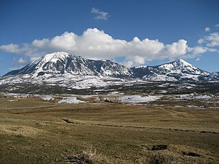
WMount Lamborn is a mountain summit in the West Elk Mountains range of the Rocky Mountains of North America. The 11,402-foot (3,475 m) peak is located in Gunnison National Forest, 5.9 miles (9.5 km) southeast by south of the Town of Paonia in Delta County, Colorado, United States. The summit of Mount Lamborn is the highest point in Delta County. Together with nearby Landsend Peak to the southwest, it lies at the western edge of the West Elks, rising dramatically nearly 6,000 ft above the valley of the North Fork Gunnison River to the west.
 W
WLandsend Peak is a prominent wedge-shaped mountain located in the West Elk Mountains range northeast of Crawford, Colorado. The summit of Landsend Peak has an elevation of 10,806 ft (3,294 m) rising dramatically about 4,000 ft (1,200 m) above the valley below. Together with nearby Mount Lamborn to the northeast, it delineates the western edge of the West Elk Mountains, and the two massifs top out about 1 mile (1.6 km) higher than the adjacent North Fork Gunnison River. Both peaks lie within the Gunnison National Forest near the physiographic boundary of the Rocky Mountains and the Colorado Plateau provinces. Geologically, Landsend Peak and Mount Lamborn are exposed igneous intrusions that geologists call laccoliths.
 W
WMarcellina Mountain is a prominent mountain summit in the West Elk Mountains range of the Rocky Mountains of North America. The 11,353-foot (3,460 m) peak is located in the Raggeds Wilderness of Gunnison National Forest, 15.0 miles (24.1 km) west by north of the Town of Crested Butte in Gunnison County, Colorado, United States.
 W
WThe Maroon Bells–Snowmass Wilderness is a U.S. Wilderness Area located in the Elk Mountains of central Colorado. The 181,535-acre (734.65 km2) wilderness was established in 1980 in the Gunnison and White River national forests. Within its boundaries are 100 miles (160 km) of trails, 6 of Colorado's fourteeners and 9 passes over 12,000 feet (3,700 m). The wilderness is named after the two peaks known as the Maroon Bells as well as Snowmass Mountain.
 W
WMatchless Mountain is a high mountain summit in the Elk Mountains range of the Rocky Mountains of North America. The 12,389-foot (3,776 m) mountain is located in Gunnison National Forest, 18.3 miles (29.4 km) east-southeast of the Town of Crested Butte in Gunnison County, Colorado, United States.
 W
WMendicant Ridge is a massive 12 miles (19 km) long high mountain located about 9 miles (14 km) east-southeast of Crawford, Colorado in the Gunnison National Forest, Gunnison County, Colorado, United States. The ridge marks the western edge of the West Elk Mountains range of the Rocky Mountains of North America and dominates the eastern skyline of the adjacent valley with about 5,000 ft (1,500 m) of vertical relief above Crawford State Park. Trending roughly northeast, Mendicant Ridge has four distinct summits that are often confused in the reference literature. From Castle Rock summit at 11,205 ft (3,415 m) on the southwest, the ridge rises to Mendicant Ridge South summit at 11,425 ft (3,482 m), then to a higher central summit at 11,603 ft (3,537 m), and finally to the Mendicant Ridge High Point located on the northeast end at an elevation of 11,841 ft (3,609 m).
 W
WMount Owen is the highest summit of the Ruby Range of the Rocky Mountains of North America. The 13,070-foot (3,984 m) thirteener is located in Gunnison National Forest at the edge of the Raggeds Wilderness, 8.5 miles (13.6 km) west-northwest of the Town of Crested Butte in Gunnison County, Colorado, United States.
 W
WThe Powderhorn Wilderness is a 62,050-acre (251.1 km2) wilderness area in Hinsdale and Gunnison Counties, Colorado, USA, located 5 miles (8.0 km) northeast of Lake City. Most of the northern part of the area, 48,115 acres (194.71 km2), about 77.5%, is located on Bureau of Land Management land and its southern portion, 13,935 acres (56.39 km2), about 22.5%, is located within the Gunnison National Forest.
WThe Raggeds Wilderness is a U.S. Wilderness Area located in the Elk Mountains northwest of Crested Butte, Colorado. The 65,393-acre (264.64 km2) wilderness was established in 1980 in the White River and Gunnison National Forests. Elevations in the wilderness range from 6,840 feet (2,080 m) in Dark Canyon to 13,535 feet (4,125 m) at the summit of Treasure Mountain. Nearly 90 miles (140 km) of trails are within the wilderness.
 W
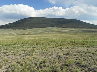
WSaddle Mountain is a large, conical mountain located on the western side of the West Elk Mountains southeast of Crawford, Colorado. Topped off by North and South Saddle peaks, Saddle Mountain's highest point, South Saddle Peak, has an elevation of 10,005 ft (3,050 m) with over 3,000 ft (910 m) of vertical relief above the valley below. Although it has the classic shape of an extinct volcano, Saddle Mountain is an exposed igneous intrusion that geologists call a laccolith.
 W
WWest Beckwith Mountain is a prominent mountain summit in the West Elk Mountains range of the Rocky Mountains of North America. The 12,185-foot (3,714 m) peak is located in the West Elk Wilderness of Gunnison National Forest, about 16.5 miles (26.5 km) southwest of Crested Butte in Gunnison County, Colorado, United States.
 W
WThe West Elk Mountains are a high mountain range in the west-central part of the U.S. state of Colorado. They lie primarily within the Gunnison National Forest, and part of the range is protected as the West Elk Wilderness. The range is primarily located in Gunnison County, with small parts in eastern Delta and Montrose counties.
 W
WThe West Elk Wilderness is a U.S. Wilderness Area located northwest of Gunnison, Colorado in the West Elk Mountains. The wilderness was established in 1964 and now protects 176,412 acres (713.91 km2) within the Gunnison National Forest. Elevations in the wilderness range from 6,800 feet (2,100 m) along Coal Creek to 13,042 feet (3,975 m) at the summit of West Elk Peak. The area supports large elk and deer populations and is busiest during the fall hunting season.
 W
WYoungs Peak is a small mountain located on the western side of the West Elk Mountains just east of and overlooking Crawford, Colorado. It has an elevation of 7,424 ft (2,263 m) with about 600 ft (180 m) of vertical relief above the town below. Although much of the mountain is covered with sedimentary rocks, Saddle Mountain is an exposed igneous intrusion that geologists call a laccolith.