 W
WAbert Rim in Lake County, Oregon is one of the highest fault scarps in the United States. It rises 2,490 feet (760 m) above the valley floor, finishing with a 820-foot (250 m) sheer-sided basalt cap. It was formed during the Miocene epoch. At that time basaltic flood lavas covered much of eastern Oregon. In subsequent faulting, great blocks were tilted and Abert Rim is at the western end of one of these blocks, while Lake Abert lies on top of another. Stretching more than 30 miles (48 km) from Lakeview north to Alkali Lake, Abert Rim is also the longest exposed fault scarp in North America.
 W
WMount Bachelor, formerly named Bachelor Butte, is a stratovolcano atop a shield volcano in the Cascade Volcanic Arc and the Cascade Range of central Oregon. Named Mount Bachelor because it "stands apart" from the nearby Three Sisters, it lies in the eastern segment of the central portion of the High Cascades, the eastern segment of the Cascade Range. The volcano lies at the northern end of the 15-mile (24 km) long Mount Bachelor Volcanic Chain, which underwent four major eruptive episodes during the Pleistocene and the Holocene. The United States Geological Survey considers Mount Bachelor a moderate threat, but Bachelor poses little threat of becoming an active volcano in the near future. It remains unclear whether the volcano is extinct or just inactive.
 W
WBelknap Crater is a shield volcano in the Cascade Range in the U.S. state of Oregon. Located in Linn County, it is associated with lava fields and numerous subfeatures including the Little Belknap and South Belknap volcanic cones. It lies north of McKenzie Pass and forms part of the Mount Washington Wilderness. Belknap is not forested and most of its lava flows are not vegetated, though there is some wildlife in the area around the volcano, as well as a number of tree molds formed by its eruptive activity.
 W
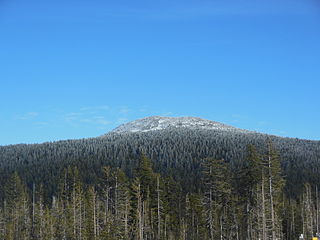
WBlack Crater is a steep-sided shield volcano in the Cascade Range of central Oregon, located north of the Three Sisters and east of McKenzie Pass. Ice Age glaciers carved a large cirque into the northern flank of the mountain, and snow often lingers in its shady depths until late summer. A United States Forest Service fire lookout tower was built on the summit in 1925, but was eventually destroyed and only remnants of the foundation remain today. A 3.7-mile (6.0 km) trail heads for the summit from the northwest on Oregon Route 242, eventually wrapping onto the northeast side for the upper part of the ascent.
 W
WBroken Top is a glacially eroded complex stratovolcano. It lies in the Cascade Volcanic Arc, part of the extensive Cascade Range in the U.S. state of Oregon. Located southeast of the Three Sisters peaks, the volcano, residing within the Three Sisters Wilderness, is 20 miles (32 km) west of Bend, Oregon in Deschutes County. Eruptive activity stopped roughly 100,000 years ago, and currently, erosion by glaciers has reduced the volcano's cone to where its contents are exposed. There are two named glaciers on the peak, Bend and Crook Glacier.
 W
WThe Christmas Valley Sand Dunes are a natural sand dune complex covering 11,000 acres (45 km2) of public lands east of Christmas Valley in Lake County, Oregon, United States, about 100 miles (160 km) southeast of Bend. The area is accessible via the Christmas Valley National Back Country Byway. The dunes are up to 60 feet (18 m) high. It is the largest inland shifting sand dune system in the Pacific Northwest. The dunes are composed mostly of ash and pumice from the eruption of Mount Mazama that formed Crater Lake 7,000 years ago. Approximately 8,900 acres (36 km2) of dunes are open to vehicles.
 W
WThe Clatsop Plains are an area of wetlands and sand dunes between the Northern Oregon Coast Range and Pacific Ocean in northwestern Oregon in the United States. They stretch from near the mouth of the Columbia River south to the vicinity of Tillamook Head near Seaside. The plains are drained by several coastal rivers include the Skipanon River and the Necanicum River, which flow parallel to the coast and empty into the Columbia at Youngs Bay near Astoria and into the Pacific Ocean near Seaside respectively. At the time, the Lewis and Clark expedition recorded a different river draining the plains which entered the Pacific near the current day Camp Rilea Armed Forces Training Center. Research, 200 years later in 2005, seems to have confirmed this by locating an old river channel.
 W
WClatsop Spit is a giant sand spit on the Pacific coast along U.S. Route 101 between Astoria and the north end of Tillamook Head in Clatsop County, northwest Oregon at the mouth of the Columbia River. The Clatsop Spit was formed by Columbia River sediment brought to the coast by the river flow after the last ice age ended approximately 8500 years ago and the ocean level rose. Here it was worked over and shaped by the wind and the waves until a vast and sandy plain was formed. In regular conversation, referring to Clatsop Spit usually refers to the northern end of the spit: the area that is bound by the Pacific to the west and the Columbia River to the northeast. In the past, the spit was known as Clatsop Sands.
 W
WThe Cline Buttes are mountains with volcanic origins that form three dome-shaped peaks located in Deschutes County in central Oregon. They are some of the eastern foothills of the Cascade Range. Situated on land administered by the Bureau of Land Management, the buttes are flanked on the east and west sides by two separate sections of the Eagle Crest Resort. On the highest summit, there is a Federal Aviation Administration site with an aircraft navigation beacon. The mountains have several hiking trails as well as a number of popular mountain bike routes.
 W
WThe Columbia Bar, also frequently called the Columbia River Bar, is a system of bars and shoals at the mouth of the Columbia River spanning the U.S. states of Oregon and Washington. The bar is about 3 miles (5 km) wide and 6 miles (10 km) long.
 W
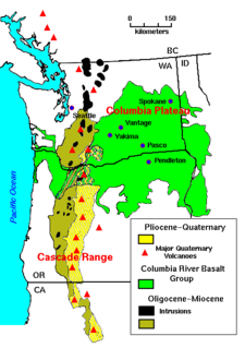
WThe Columbia Plateau is a geologic and geographic region that lies across parts of the U.S. states of Washington, Oregon, and Idaho. It is a wide flood basalt plateau between the Cascade Range and the Rocky Mountains, cut through by the Columbia River.
 W
WThe Columbia River drainage basin is the drainage basin of the Columbia River in the Pacific Northwest region of North America. It covers 668,000 km2 or 258,000 sq mi. In common usage, the term often refers to a smaller area, generally the portion of the drainage basin that lies within eastern Washington.
 W
WCrack in the Ground is a volcanic fissure about 2 miles (3.2 km) long with depths measuring nearly 30 feet (9 m) below ground level in Central Oregon, United States. The formation of the fissure occurred approximately between 700,000 and 12,000 years ago. The eruptions from the Four Craters Lava Field were accompanied by a slight sinking of the older rock surface, forming a shallow, graben-like structure about 2 miles (3.2 km) wide and extending to the south into an old lake basin. Crack in the Ground marks the western edge of this small, volcano-tectonic depression. The crack is the result of a tension fracture along a hingeline produced by the draping of Green Mountain lava flows over the edge of upthrown side of the concealed fault zone. The fissure is located at the southwest corner of Four Craters Lava Field. Hikers can walk the length of the main crack and explore its tributaries.
 W
WThe Crooked River caldera is a large and ancient volcano that straddles three central Oregon counties. The diameter of the caldera is about 41 km x 27 km and is notable for the welded tuff present at Gray Butte, Smith Rock, Powell Buttes, Grizzly Mountain and Barnes Butte. The volcano is considered extinct and last erupted about 29.5 Ma.
 W
WDevils Churn is a narrow inlet of the Pacific Ocean in Lincoln County, Oregon, United States, south of Yachats. It is located in the Siuslaw National Forest and is accessible via the Restless Waters trail from the Cape Perpetua Scenic Area visitor's center or the U.S. Route 101 overlook. Access to the trail requires a United States Forest Service pass.
WGray Butte is a volcanic butte in the southeast corner of Jefferson County, Oregon, United States. It is composed of welded tuff and is a part of the Crooked River caldera. A recreation trail for hiking, horseback riding, and mountain biking leads up the side of the butte. The butte is located near the popular tourist site of Smith Rock.
 W
WGrizzly Mountain is located in Crook County, Central Oregon near the city of Prineville. Its summit is at 5,629 feet (1,716 m). It is composed of welded tuff and is a part of the Crooked River caldera.
WHampton Buttes is a small range of mountains or hills in the U.S. state of Oregon. The range lies mostly in Crook County but extends south and west into Deschutes County in Central Oregon near the unincorporated community of Hampton. U.S. Route 20, an east–west highway, skirts the range to the south. The upper South Fork Crooked River flows north along the eastern base of the range.
 W
WThe Coburg Hills are a range of foothills of the western Cascade Range of Lane and Linn counties in the U.S. state of Oregon. They are located northeast of Eugene and east of Coburg, between the Mohawk Valley and Willamette Valley.
 W
WHorse Ridge is series of volcanic ridges in eastern Deschutes County, Oregon, United States. It is located south of Highway 20, west of the Millican community, and south of the Oregon Badlands Wilderness. The Horse Ridge Research Natural Area occupies predominantly north and northeast facing slopes of the ridges. It was established in 1967. The Brothers Fault Zone bisects the ridges and exposed mafic lava rock has been dated to 7.5 ma.
 W
WThe Klamath Basin is the region in the U.S. states of Oregon and California drained by the Klamath River. It contains most of Klamath County and parts of Lake and Jackson counties in Oregon, and parts of Del Norte, Humboldt, Modoc, Siskiyou, and Trinity counties in California. The 15,751-square-mile (40,790 km2) drainage basin is 35% in Oregon and 65% in California. In Oregon, the watershed typically lies east of the Cascade Range, while California contains most of the river's segment that passes through the mountains. In the Oregon-far northern California segment of the river, the watershed is semi-desert at lower elevations and dry alpine in the upper elevations. In the western part of the basin, in California, however, the climate is more of temperate rainforest, and the Trinity River watershed consists of a more typical alpine climate.
 W
WLava Butte is a cinder cone in central Oregon, United States, just west of U.S. Route 97 between the towns of Bend, Oregon, and Sunriver, Oregon. It is part of a system of small cinder cones on the northwest flank of Newberry Volcano, a massive shield volcano which rises to the southeast. The cinder cone is capped by a crater which extends about 60 feet (20 m) deep beneath its south rim, and 160 feet (50 m) deep from the 5,020-foot (1,530 m) summit on its north side. Lava Butte is part of the Newberry National Volcanic Monument.
 W
WLava Cast Forest is a visitor destination within the Newberry National Volcanic Monument near Bend, Oregon, of the United States. It is a geologic feature containing a 6,000 year old lava flow that created lava molds of ancient trees. It's located about 25 total miles south of Bend and is accessible via a 9-mile (14 km) gravel road from U.S. Highway 97. The site includes paid parking and a paved interpretive loop trail, with some sections too narrow or steep for wheelchairs.
 W
WMaiden Peak is a steep-sided shield volcano in the Cascade Range of central Oregon. It is the highest point in the 43-mile (69 km) distance between Mount Bachelor and Diamond Peak. Ice Age glaciers carved a large cirque into the northeast flank of the mountain, exposing magma which hardened in the volcano's conduits to form the numerous rock pinnacles now found in the upper part of the cirque.
 W
WMount Mazama is a complex volcano in the state of Oregon, United States, in a segment of the Cascade Volcanic Arc and Cascade Range. Most of the mountain collapsed following a major eruption approximately 7,700 years ago. The volcano is in Klamath County, in the southern Cascades, 60 miles (97 km) north of the Oregon-California border. Its collapse formed a caldera that holds Crater Lake. The mountain is in Crater Lake National Park. Mount Mazama originally had an elevation of 12,000 feet (3,700 m), but following its climactic eruption this was reduced to 8,157 feet (2,486 m). Crater Lake is 1,943 feet (592 m) deep, the deepest freshwater body in the US and the second deepest in North America after Great Slave Lake in Canada.
 W
WModoc Point is a cliff on the east shore of Upper Klamath Lake, in Klamath County, Oregon, United States, approximately 15 miles north of Klamath Falls on U.S. Route 97. It is part of the larger cliff known as Modoc Rim or Modoc Ridge.
 W
WNewberry Volcano is a large active shield volcano located about 20 miles (32 km) south of Bend, Oregon, United States, 35 miles (56 km) east of the major crest of the Cascade Range, within the Newberry National Volcanic Monument. Its highest point is Paulina Peak. The largest volcano in the Cascade Volcanic Arc, Newberry has an area of 1,200 square miles (3,100 km2) when its lava flows are taken into account. From north to south, the volcano has a length of 75 miles (121 km), with a width of 27 miles (43 km) and a total volume of approximately 120 cubic miles (500 km3). It was named for the geologist and surgeon John Strong Newberry, who explored central Oregon for the Pacific Railroad Surveys in 1855. The surrounding area has been inhabited by Native American populations for more than 10,000 years.
 W
WThe Oregon Dunes National Recreation Area is located on the Oregon Coast, stretching approximately 40 miles (64 km) north of the Coos River in North Bend to the Siuslaw River in Florence, and adjoining Honeyman State Park on the west. It is part of Siuslaw National Forest and is administered by the United States Forest Service.
 W
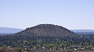
WPilot Butte is a lava dome that was created from an extinct volcano located in Bend, Oregon. It is a cinder cone butte which rises nearly 500 feet (150 m) above the surrounding plains. Bend is one of four cities in the United States to have a volcano within its boundaries. Portland, with Mount Tabor, is the only other city in Oregon with a volcano within its city limits. Jackson Volcano in Jackson, Mississippi, and Diamond Head in Honolulu are the others.
 W
WSmith Rock State Park is a state park located in central Oregon's High Desert near the communities of Redmond and Terrebonne. The day-use area of the park is open daily from dawn to dusk. The park also has a camping area as well that accommodates tent camping only. Its sheer cliffs of tuff and basalt are ideal for rock climbing of all difficulty levels. Smith Rock is generally considered the birthplace of modern American sport climbing, and is host to cutting-edge climbing routes. It is popular for sport climbing, traditional climbing, multi-pitch climbing, and bouldering.
 W
WThe Three Sisters are closely spaced volcanic peaks in the U.S. state of Oregon. They are part of the Cascade Volcanic Arc, a segment of the Cascade Range in western North America extending from southern British Columbia through Washington and Oregon to Northern California. Each more than 10,000 feet (3,000 m) in elevation, they are the third-, fourth- and fifth-highest peaks in Oregon. Located in the Three Sisters Wilderness at the boundary of Lane and Deschutes counties and the Willamette and Deschutes national forests, they are about 10 miles (16 km) south of the nearest town, Sisters. Diverse species of flora and fauna inhabit the area, which is subject to frequent snowfall, occasional rain, and extreme temperature variation between seasons. The mountains, particularly South Sister, are popular destinations for climbing and scrambling.
 W
WTom Dick and Harry Mountain is a two-mile-long volcanic mountain in Clackamas County in the U.S. state of Oregon. It is located 7.2 miles (11.6 km) southwest of Mount Hood, 1.9 miles (3.1 km) west-southwest of Government Camp between the Zigzag River and Still Creek, south of Zigzag Mountain. Because of its proximity to Mount Hood, it is considered a foothill.
 W
WTumalo Mountain is a shield volcano in the Cascade Range of central Oregon, located just northeast of Mount Bachelor across the Cascade Lakes Scenic Byway. Ice age glaciers carved a large cirque into the northeast flank of the mountain, producing a bowl which is popular with local backcountry skiers. A United States Forest Service fire lookout tower was built on the summit in the 1930s, but abandoned in the 1970s and subsequently removed. A trail to the summit ascends the southwest flank of the volcano.
 W
WMount Washington is a deeply eroded volcano in the Cascade Range of Oregon. It lies within Deschutes and Linn counties and is surrounded by the Mount Washington Wilderness area.
 W
WThe West Coast or Pacific Coast is the coastline along which the continental Western United States meets the North Pacific Ocean. As a region, this term most often refers to the coastal states of California, Oregon, Washington, and Alaska. More specifically, it refers to an area defined on the east by the Alaska Range, Cascade Range, Sierra Nevada, and Mojave Desert, and on the west by the Pacific Ocean. The United States Census groups the five states of California, Oregon, Washington, Alaska, and Hawaii together as the Pacific States division.