 W
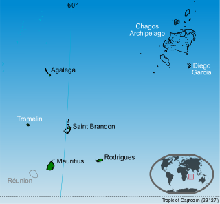
WThe Chagos Archipelago or Chagos Islands are a group of seven atolls comprising more than 60 individual tropical islands in the Indian Ocean about 500 kilometres (310 mi) south of the Maldives archipelago. This chain of islands is the southernmost archipelago of the Chagos-Laccadive Ridge, a long submarine mountain range in the Indian Ocean.
 W
WThe Chagossians are a Creole ethnic group native to the Chagos Islands, specifically Diego Garcia, Peros Banhos, and the Salomon island chain, as well as other parts of the Chagos Archipelago, from the late 18th century until the middle of 20th century. Most Chagossians now live in Mauritius and the United Kingdom after being evicted by the British government in the late 1960s and early 1970s so that Diego Garcia, the island where most Chagossians lived, could serve as the location for a United States military base. Today, no Chagossians live on the island of Diego Garcia, as it is now the site of the military base Camp Justice.
 W
WThe 1983 Chagos Archipelago earthquake occurred on November 30 at 17:46 UTC in the region of the Chagos Archipelago, British Indian Ocean Territory. This earthquake had a magnitude of Ms 7.7. This earthquake occurred in the Indian Plate near the Central Indian Ridge. The Central Indian Ridge is unusually active in near-ridge earthquakes. The intense seismic activity in this region may indicate an early stage of converging plate boundary, which is responsible for the N-S extension near Chagos. There was a 40 cm tsunami reported in Victoria, Seychelles.
 W
WBenares Shoals, or Benares Shoal, is a submerged coral reef, an isolated patch located at 5°15′S 071°40′E, just 6 kilometres (3.7 mi) west-northwest of Île Pierre, the closest island of Peros Banhos atoll in the northern Chagos Archipelago. It measures about 3 kilometres (2 mi) east–west, with a width of about 700 metres (2,300 ft) and an area of 2 square kilometres (0.77 sq mi). The least depth at the western end is 4.5 metres (15 ft).
 W
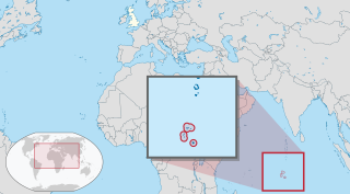
WThe British Indian Ocean Territory (BIOT) is a British overseas territory of the United Kingdom situated in the Indian Ocean halfway between Tanzania and Indonesia. The territory comprises the seven atolls of the Chagos Archipelago with over 1,000 individual islands – many very small – amounting to a total land area of 60 square kilometres (23 sq mi). The largest and most southerly island is Diego Garcia, 27 km2 (10 sq mi), the site of a joint military facility of the United Kingdom and the United States.
 W
WCamp Thunder Cove, formerly Camp Justice is a United States Navy and Air Forces support facility within the US-UK Naval Support Facility on Diego Garcia, a small, strategically located, isolated island in the Indian Ocean. The island is in the Chagos Archipelago, part of the British Indian Ocean Territory.
 W
WCauvin Bank is a wholly submerged atoll structure in the Southern Part Chagos Archipelago at 6°49′S 72°22′E, just about 7 km (4 mi) South of the Southeastern corner of the rim of the Great Chagos Bank. It is roughly circular in shape, with a diameter of 4 km (2 mi), and an area of about 12 km2 (5 sq mi). There are least depths between 9 to 11 m in the Northern part of the reef. The closest land is the northernmost part of Diego Garcia atoll, Middle Island, 41 km (25 mi) to the South.
WCenturion Bank is a wholly submerged atoll structure in the Southwest of the Chagos Archipelago. It is about almost 10 km (6 mi) long northwest-southeast, and more than 3 km (2 mi). The reef area is about 25 km2 (9.7 sq mi). The closest land is the Egmont Atoll located 122 km (76 mi) to the NNE. The Centurion Bank is the southernmost feature of the Chagos group.
 W
WSovereignty over the Chagos Archipelago is disputed between Mauritius and the United Kingdom. Mauritius has repeatedly asserted that the Chagos Archipelago is part of its territory and that the United Kingdom (UK) claim is a violation of United Nations resolutions banning the dismemberment of colonial territories before independence. The UK government has stated that it has no doubt about its sovereignty over the Chagos, and has also said that the Chagos will be given to Mauritius once the islands are no longer required for defence purposes. Given the absence of any progress with the UK, Mauritius has decided to "internationalise" the dispute and take up the matter at all appropriate legal and political forums.
WColvocoresses Reef is a wholly submerged atoll in the Indian Ocean. It is located in the northeastern part of the Chagos Archipelago, near Speakers Bank and Blenheim Reef. The reef is 8 km long, and measures 1 to 2 km across. Breakers are visible only during heavy seas.
 W
WDanger Island is the westernmost and the southernmost island of the Great Chagos Bank, which is the world's largest coral atoll structure, located in the Chagos Archipelago in the Indian Ocean.
WThe deportation of Chagossians from the Chagos Archipelago was the forced expulsion of the inhabitants of the island of Diego Garcia and the other islands of the British Indian Ocean Territory (BIOT) by the United Kingdom, at the request of the United States, beginning in 1968 and concluding on 27 April 1973 with the evacuation of Peros Banhos atoll. The people, known at the time as the Ilois, are today known as Chagos Islanders or Chagossians.
 W
WEagle Islands is a group of two islands in the Chagos Archipelago. They are located on the central-western rim of the Great Chagos Bank, which is the world's largest coral atoll structure.
WGanges Bank is a wholly submerged atoll structure in the Southwest of the Chagos Archipelago. It is about 7 by 5 km in size, yielding an area of about 30 km2. The closest land is the Egmont Atoll located 87 km (54 mi) to the NNE.
WÎle de la Passe is an island of the Peros Banhos atoll in the Chagos Archipelago of the British Indian Ocean Territory.
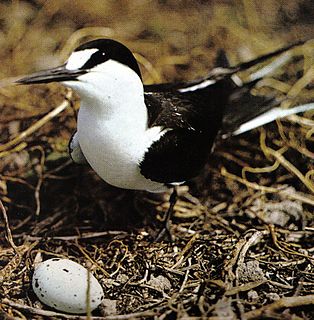
WIle Longue is a 26 ha island on the Peros Banhos Atoll in the Chagos Archipelago of the British Indian Ocean Territory. It is part of the Peros Banhos strict nature reserve and has been identified as an Important Bird Area by BirdLife International because of its significance as a breeding site for sooty terns, of which 32,000 pairs were recorded in a 2004 survey.
WIle Parasol is an 8 ha island on the Peros Banhos Atoll in the Chagos Archipelago of the British Indian Ocean Territory. It is part of the Peros Banhos strict nature reserve and has been identified as an Important Bird Area by BirdLife International because of its significance as a breeding site for sooty terns, of which 14,000 pairs were recorded in a 2004 survey.
WÎle Yeye is an island of the Peros Banhos atoll in the Chagos Archipelago of the British Indian Ocean Territory. It is the island of the Chagos that is closest to the Maldives.
 W
WThe Maldives-Lakshadweep-Chagos Archipelago tropical moist forests is a tropical moist broadleaf forest ecoregion in South Asia. It spans a chain of coralline islands in the Indian Ocean, including Lakshadweep, a union territory of India; the Maldives, an independent country; and the British Indian Ocean Territory, an overseas territory of the United Kingdom.
 W
WMiddle Brother, also known as Île du Milieu, is an 8-hectare coral island on the Great Chagos Bank atoll of the Chagos Archipelago in the British Indian Ocean Territory. It is one of the three islands in the Three Brothers group on the western side of the atoll, and forms part of the Chagos Archipelago strict nature reserve. It has been identified as an Important Bird Area by BirdLife International for its significance as a breeding site for seabirds, notably sooty terns, of which 12,500 pair were recorded in a 2004 survey.
WMoresby Island is an island on the Peros Banhos Atoll in the Chagos Archipelago of the British Indian Ocean Territory.
 W
WThe Chagos Islands national football team is a football team ostensibly representing the territory of the Chagos Archipelago in the Indian Ocean. However, this area, which falls under the administration of the British Indian Ocean Territory, is uninhabited save for the presence of a US military base on the island of Diego Garcia, after the United Kingdom evicted the local population between 1967 and 1973. As a consequence, the team in fact represents the Chagossian diaspora around the world. They are led by Sussex-based manager Jimmy Ferrar, who has previously managed at Oakwood, Crawley Down and Alfold where he won the Southern Combination Div 1 for season 2018/19.
 W
WNaval Support Facility Diego Garcia is a British Ministry of Defence facility leased to the United States Navy, located on the atoll Diego Garcia in the Indian Ocean.
WNelsons Island or Nelson Island or Isle Legour is a small uninhabited island in the Great Chagos Bank, of the Chagos Archipelago in the Indian Ocean. As a protected nature reserve, access to the island is strictly restricted.
 W
WNorth Brother, also known as Île du Nord, is a round 6 ha coral island on the Great Chagos Bank atoll of the Chagos Archipelago in the British Indian Ocean Territory. It is one of the three islands in the Three Brothers group on the western side of the atoll, and forms part of the Chagos Archipelago strict nature reserve. It has been identified as an Important Bird Area by BirdLife International because of its significance as a breeding site for 20,000 seabirds, notably Audubon's shearwaters of which 420 pairs were recorded in a 2004 survey.
 W
WOchrosia oppositifolia grows as a small to medium-sized tree up to 25 metres (82 ft) tall, with a trunk diameter of up to 50 centimetres (20 in). Its flowers feature a creamy to white corolla. Its habitat is coastal forest, bush or open areas to 100 metres (330 ft) altitude, rarely inland. Local medicinal uses include as a carminative and in high doses as an abortifacient. Ochrosia oppositifolia is native to regions from the Seychelles through tropical Asia to the Pacific.
WOwen Bank is a wholly submerged atoll structure in the Chagos Archipelago, Indian Ocean. The reported location is 06°47'S, 070°14'E to 06°48'S, 070°15'E, thus the bank is the westernmost feature of the Chagos group. The closest islands are Danger Island on the Great Chagos Bank, and Île Sipaille in the Egmont Atoll, both located about 120 km (75 mi) East-North-East of Owen Bank.
WPetite Île Bois Mangue is a 9 ha island on the Peros Banhos Atoll in the Chagos Archipelago of the British Indian Ocean Territory. It is part of the Peros Banhos strict nature reserve and has been identified as an Important Bird Area by BirdLife International because of its significance as a breeding site for lesser noddies, of which 12,000 pairs were recorded in a 2004 survey.
WPitt Bank is a wholly submerged atoll structure in the Southwest of the Chagos Archipelago. It is almost 56 km long Northwest to Southeast, with a width between 20 and 30 km. It stretches from 06°48'S to 07°16'S and 071°06'E to 071°36'E. The total size is 1317 km, making it the second largest ocean bank in the Chagos Archipelago, after the Great Chagos Bank, and before Speakers Bank. The closest land is Île Lubine of Egmont Atoll, located 22 km northeast off the northern end of Pitt Bank. The least depth is 7 metres at the Southeastern Rim, and the deepest areas of the former lagoon reach 44 metres.
 W
WScadoxus multiflorus is a bulbous plant native to most of sub-Saharan Africa from Senegal to Somalia to South Africa. It is also native to Arabian Peninsula and to the Seychelles. It is naturalized in Mexico and in the Chagos Archipelago. It is grown as an ornamental plant for its brilliantly coloured flowers, either in containers or in the ground in where the climate is suitable. There are three recognized subspecies. Strongly toxic like other Scadoxus species, it has been used as a component of arrow poisons and fishing poisons, as well as in traditional medicine. Common names, some of which are used for other species, include blood lily, ball lily, fireball lily, blood flower, Katherine-wheel, oxtongue lily, poison root and powderpuff lily.
WSea Cow Island, also known as Île Vache Marine, is a round 18 ha island on the Great Chagos Bank atoll of the Chagos Archipelago in the British Indian Ocean Territory. It was named after the dugongs that were once abundant in the area, although they have since become regionally extinct. It is the smaller of the two islands in the Eagle Islands group on the western side of the atoll and forms part of the Chagos Archipelago strict nature reserve. It has been identified as an Important Bird Area by BirdLife International because of its significance as a breeding site for brown noddies, of which 11,500 pairs were recorded in a 2004 survey.
 W
WSouth Brother, also known as Île du Sud, is a 23 ha coral island on the Great Chagos Bank atoll of the Chagos Archipelago in the British Indian Ocean Territory. It is one of the three islands in the Three Brothers group on the western side of the atoll, and forms part of the Chagos Archipelago strict nature reserve. It has been identified as an Important Bird Area by BirdLife International because of its significance as a breeding site for seabirds, including brown noddies and lesser noddies.
 W
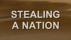
WStealing a Nation is a 2004 Granada Television documentary about the British–American clandestine operation that saw the expulsion of the Chagossian population who have lived on Diego Garcia and neighboring islands since the late 18th century. More than 2,000 people were exiled to Mauritius between 1967 and 1973, so that Diego Garcia could become a United States airbase (see depopulation of Chagossians from the Chagos Archipelago). The film contains a series of interviews with Chagossians, who have been deprived of their right of return and forced to live in abject poverty. Stealing a Nation was written and directed by John Pilger, and produced and directed by Christopher Martin; reconstruction footage was directed by Sean Crotty.
WThe Three Brothers are a group of three small coral islands 20 kilometres east of Eagle Islands along the central western rim of the Great Chagos Bank, which is the world's largest coral atoll structure, located in the Chagos Archipelago.
WVictory Bank is a wholly submerged atoll structure in the Northern Chagos Archipelago at 05°33′S 72°14′E. It is located 17 kilometres NNW of Nelson Island, the only island on the Northern rim of the Great Chagos Bank. Île Boddam, of the Salomon Islands lies 17 kilometres to the North.
WWight Bank is a small, wholly submerged atoll structure in the Southwest of the Chagos Archipelago, Indian Ocean. It is located 6 kilometres to the SE off the southeastern tip of Pitt Bank at 7°25′S 71°32′E. It is less than 2 km in diameter, and its total area is about 3 square kilometres. The closest piece of land is Île Sudest of Egmont Atoll, at 80 km (50 mi) NNW. Diego Garcia is 94 km (58 mi) to the east. The least charted depth is 8.5 km (5.3 mi).