 W
WA cinder cone is a steep conical hill of loose pyroclastic fragments, such as either volcanic clinkers, volcanic ash, or cinder that has been built around a volcanic vent. The pyroclastic fragments are formed by explosive eruptions or lava fountains from a single, typically cylindrical, vent. As the gas-charged lava is blown violently into the air, it breaks into small fragments that solidify and fall as either cinders, clinkers, or scoria around the vent to form a cone that often is symmetrical; with slopes between 30–40°; and a nearly circular ground plan. Most cinder cones have a bowl-shaped crater at the summit.
 W
WA list of cinder cones is shown below.
 W
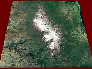
WAnkaratra is a cinder cone volcano range located about 50 km (30 mi) southwest of Antananarivo, the capital city of Madagascar. It lies between the towns of Arivonimamo to the North, Ambatolampy to the East, Faratsiho to the West and Betafo to the South. It is located in the Central Highlands. The highest peak in Ankaratra is Tsiafajavona, at 2,644 metres above sea level. Some trace of activity remains in the southernmost part of the range, creating hot springs in the area around Antsirabe. The last eruption of Ankaratra took place in the very recent Quaternary.
 W
WAuquihuato is a cinder cone in the Andes of Peru, 4,980 metres (16,339 ft) high. It is situated in the Ayacucho Region, Paucar del Sara Sara Province, on the border of the districts Colta and Oyolo. Auquihuato lies northeast of Sara Sara volcano.
 W
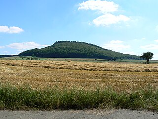
WThe Bausenberg is a cinder cone hill, 339.8 m above sea level (NN), in the East Eifel in the county of Ahrweiler in the German state of Rhineland-Palatinate.
 W
WCinder Hill is a prominent dissected volcano, 305 metres (1,000 ft) high, consisting of layers of red basalt scoria and cinders and abundant olivine nodules, standing between Harrison Stream and Wilson Stream on the ice-free lower west slopes of Mount Bird, Ross Island. It was mapped and descriptively named by the New Zealand Geological Survey Antarctic Expedition, 1958–59.
 W
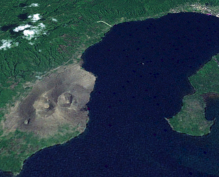
WEl Jorullo is a cinder cone volcano in Michoacán, central Mexico, on the southwest slope of the central plateau, 33 miles southeast of Uruapan in an area known as the Michoacán-Guanajuato volcanic field. It is about 6 miles (10 km) east-northeast of La Huacana. Its current elevation is 4,360 ft (1,329 m). El Jorullo has four smaller cinder cones which have grown from its flanks. The vents of El Jorullo are aligned in a northeast to southwest direction. Lava from these vents cover nine square km around the volcano. Later eruptions produced lavas that had higher silica contents making them thicker than the earlier basalts and basaltic andesite lavas. El Jorullo's crater is about 1,300 by 1,640 feet wide and 490 feet (150 m) deep.
 W
WMount Elephant is a 380-metre-high (1,250 ft) conical breached scoria cone formed by a dormant volcano, located 1 km from the town of Derrinallum in southwestern Victoria, Australia. It is a prominent landmark that forms the eastern gateway to the Kanawinka Geopark from the Hamilton Highway at Derrinallum.
 W
WGegham mountains, Armenian: Գեղամա լեռնաշղթա are a range of mountains in Armenia. The range is a tableland-type watershed basin of Sevan Lake from east, inflows of rivers Araks and Hrazdan from north and west, Azat and Vedi rivers from south-west and Arpachai river from south. The average elevation of the Gegham mountain range is near 2500m. The range is of volcanic origin including many extinct volcanoes. The range is 70 km length and 48 km width, and stretch between Lake Sevan and the Ararat plain. The highest peak of the Gegham mountains is the Azhdahak, at 3597m. They are formed by a volcanic field, containing Pleistocene-to-Holocene lava domes and cinder cones. The highland reaches a height of 1800–2000m up to 3000m in the dividing ridge.
 W
WGolets-Torny Group is a group of cinder cones located in the northern part of Iturup Island, Kuril Islands, Russia.
 W
WThe Hochsimmer is a volcanic cone, 587.9 m above sea level (NHN), in the Eifel Mountains in Germany. It rises near Ettringen in the Rhineland-Palatine county of Mayen-Koblenz. At the summit is an observation tower, the Hochsimmer Tower.
 W
WHverfjall is a tephra cone or tuff ring volcano in northern Iceland, to the east of Mývatn.
WIvao Group is a group of cinder cones located in the southern part of Urup Island, Kuril Islands, Russia.
 W
WKarapınar Field is a volcanic field in central Anatolia, Asian Turkey.
 W
WThe Karmelenberg is a wooded cinder cone that was formed by volcanic activity. It marks the southeastern end of the East Eifel volcano field and rises to a height of 372 m above sea level (NHN), about 170 metres above the Pellenz region, and is visible from a long way off.
 W
WKostakan is a north-south trending chain of cinder cones located in the southern part of Kamchatka Peninsula, Russia.
 W
WKula is a volcanic field located in western Turkey. Kula field consists of a broad area of cinder cones and maars. It is the westernmost volcano of Turkey. The volcanic character of the area was recognized in antiquity, when it was named Katakekaumene from the appearance of the environment, which was mostly suited for viticulture. Volcanism began in the Miocene and over three stages continued in the Holocene. It is associated with the presence of two neighbouring active graben structures. Most cones are of small size and one of them has its internal structure exposed. Total volume of the volcanic field extrusion is about 2,3 km3 and the lavas are rich in xenoliths. The plant succession on the lava fields and cones was subject of a study in 1974, which found that the vegetation is influenced both by climate factors such as temperature and precipitation and the orientation of the sides of the volcanoes in question. Footprints of prehistoric humans have been found in the area. The area is a geopark recognized by UNESCO given the universal and scientific value.
 W
WMount Leura is a 313-metre scoria cone surrounding a dry crater 100 m deep and is the central and most obvious component of a larger volcanic complex southeast of the town of Camperdown located in western Victoria, Australia, 194 kilometres (121 mi) south west of the state capital, Melbourne. The inactive volcano is thought to have last erupted between 5,000 and 20,000 years ago. The name means "big nose" in local aboriginal dialect.
WLomonosov Group is a volcanic group of cinder cones located in the southern part of Paramushir Island, Kuril Islands, Russia.
 W
WManda-Inakir is a system of fissure vents and cinder cones located along the borders between Djibouti, Eritrea and Ethiopia. Last erupting in 1928, it produced a cinder cone called Kammourta. It has an elevation of over 600 metres.
 W
WMount Mayabobo is a cinder cone situated at the base of Mount Banahaw, in Barangay Mayabobo, Candelaria, Quezon in Luzon island, Philippines. Approximately with a height of 300 metres (980 ft), it is a tourist destination for local residents of Candelaria and nearby municipalities, since it has a telecommunication site at its summit for sight-seeing and hiking.
 W
WMount Batok is a cinder cone located in East Java, Indonesia. This volcano has an elevation of 2,440 meters above sea level, and is located between four regencies: Probolinggo Regency, Pasuruan Regency, Lumajang Regency, and Malang Regency. The location of Mount Batok is west from Mount Bromo. This mountain is one of the inactive volcanoes located within the Tengger caldera. Mount Batok is part of Bromo Tengger Semeru National Park.
 W
WThe Nerother Kopf is the conical hill of an extinct volcano near Neroth in the Eifel mountains. It is 651.7 m above sea level (NHN) and situated in the county of Vulkaneifel in the German state of Rhineland-Palatinate.
 W
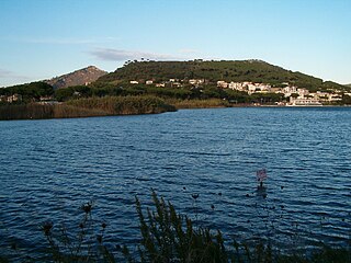
WMonte Nuovo is a cinder cone volcano within the Campi Flegrei caldera, near Naples, southern Italy. A series of damaging earthquakes and changes in land elevation preceded its only eruption, during the most recent part of the Holocene, which lasted from September 29 to October 6, 1538, when it was formed. The event is important in the history of science because it was the first eruption in modern times to be described by a large number of witnesses. The eruptive vent formed next to the medieval village of Tripergole on the shores of the then-much larger Lake Lucrino. The thermal bath village, which had been inhabited since ancient Roman times and was home to notable Roman-era buildings including Cicero's villa, was completely buried by ejecta from the new cinder cone. Tripergole's ruins and its important thermal springs completely disappeared under Monte Nuovo such that the exact location of the village can no longer be identified.
 W
WŌhuiarangi / Pigeon Mountain is a 55 m (180 ft) high volcanic cone at Half Moon Bay, near Howick and Bucklands Beach, in Auckland, New Zealand. The cone forms the last part of volcanic activity that lasted many years. An earlier explosive eruption, created the prominent tuff ring that is still clearly visible extending in an arc south of Sunderlands Road. Two much smaller craters were formed to the north west of the main cone. The smaller lies buried under Pigeon Mountain Road outside number 18, and the other forms 'Heights Park' – a private reserve for the owners of 29 – 41 Pigeon Mountain Road and 14 – 36 Prince Regent Drive and 33 – 39 Tyrian Close. It forms part of the Auckland volcanic field and is popular for scientific school trips.
 W
WThe Pinacate Peaks are a group of volcanic peaks and cinder cones located mostly in the Mexican state of Sonora along the international border adjacent to the U.S. state of Arizona, surrounded by the vast sand dune field of the Gran Desierto de Altar, at the desert's southeast.
 W
WThe Rockeskyller Kopf near Rockeskyll in the county of Vulkaneifel in the German state of Rhineland-Palatinate is a hill, 554.6 m above sea level (NHN), in the Eifel mountains. It is an extinct volcano complex from the Quaternary period, around 360,000 years old and is designated as a natural monument (ND-7233-420).
 W
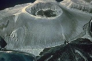
WMount Suribachi is a 169-metre (554 ft)-high mountain on the southwest end of Iwo Jima in the northwest Pacific Ocean under the administration of Ogasawara Subprefecture, Tokyo Metropolis, Japan.
WTolmachev Dol is a volcanic highland located in the southern part of Kamchatka Peninsula, Russia, northeast of Opala volcano. The cones and lava fields cover a broad area around Lake Tolmachev.
 W
WTsaghkunyats Mountains, Armenian: Ծաղկունյաց լեռնաշղթա, are a range of mountains in Armenia, mainly in the provinces of Kotayk and Aragatsotn.
 W
WUlysses Colles is an official name for conical edifices associated with flows in Ulysses Fossae in the Tharsis quadrangle of Mars. These conical edifices form small volcanic field which were interpreted as result of explosive eruptions on Mars where martian equivalents to terrestrial pyroclastic cones, cinder cones respectively, exist. This field is situated north of the shield volcanoes Biblis Patera and Ulysses Patera and it is superposed on an old, elevated window of fractured crust of Ulysses Fossae, probably of early Hesperian age, which survived flooding by younger lava flows associated with plain-style volcanism in Tharsis.
 W
WThe Veitskopf is hill, 428 m above sea level (NHN), in the Eifel mountains of Germany. It is located in the county of Ahrweiler in the state of Rhineland-Palatinate. It rises north of the lake of Laacher See in the area of the village of Wassenach.
WVernadskii Ridge is a volcanic group located in the northern part of Paramushir Island, Kuril Islands, Russia.
 W
WThe Bárcena volcano is classified as a dormant, or historical, cinder cone type volcano that encompasses the southern end of the San Benedicto Island, Mexico. It is grouped with a chain of volcanic islands known as the Revillagigedo Islands, Mexico. These islands are situated in close proximity to each other, and can be found in the Pacific ocean. They are also considered to be part of the Trans-Mexican Volcanic Belt. Volcán Bárcena is positioned 220 miles off the south-eastern coast of the Baja California Peninsula. The closest city to Barcena is Cabo San Lucas, Mexico.
 W
WVulcan is a pumice cone in Papua New Guinea. It is a sub-vent of the Rabaul caldera and lies on its western rim. Its most recent eruption was in 1994, when it and another vent, Tavurvur, forced the city of Rabaul to be temporarily abandoned and the local administrative centres of East New Britain Province to be moved to a new capital, Kokopo. Today, the slopes of Vulcan are now forested, as a result of dormancy since 1994.
WMount Warrnambool is a single large scoria cone volcano that is 216 metres (709 ft) high. It is 16 kilometres (10 mi) southwest of Terang, Victoria, Australia. It is visible from the Princes Highway on the way to Warrnambool.