 W
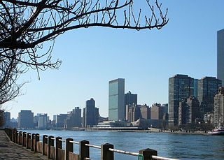
WThe East River is a salt water tidal estuary in New York City. The waterway, which is actually not a river despite its name, connects Upper New York Bay on its south end to Long Island Sound on its north end. It separates the borough of Queens on Long Island from the Bronx on the North American mainland, and also divides Manhattan from Queens and Brooklyn, which is also on Long Island. Because of its connection to Long Island Sound, it was once also known as the Sound River. The tidal strait changes its direction of flow frequently, and is subject to strong fluctuations in its current, which are accentuated by its narrowness and variety of depths. The waterway is navigable for its entire length of 16 miles (26 km), and was historically the center of maritime activities in the city.
 W
WOn March 11, 2018, a sightseeing helicopter crashed into the East River off the Upper East Side of Manhattan, New York City, killing 5 people. Two passengers died at the scene, and three others were pronounced dead at the hospital. The pilot escaped the helicopter following the crash. The aircraft was operated by Liberty Helicopters for FlyNyon. Two people were from New York state; another two were from Dallas, Texas; and the fifth was from Argentina. The pilot is from Connecticut.
 W
WAnable Basin is a 500-foot-long (150 m) artificial inlet of the East River located in the Long Island City neighborhood of Queens, New York City. It was carved in 1868 to serve the large concentrations of industrial firms in the neighborhood.
 W
WBroadway Ferry was a ferry landing in Williamsburg, Brooklyn, New York City, United States at the foot of Broadway. Boats connected it to the Grand Street Ferry, East 23rd Street Ferry, and James Slip landings in Manhattan. In Brooklyn, the Broadway El ended at the ferry.
 W
WBrooklyn Bridge Park is an 85-acre (34 ha) park on the Brooklyn side of the East River in New York City. Designed by landscape architecture firm Michael Van Valkenburgh Associates, the park is located on a 1.3-mile (2.1 km) plot of land from Atlantic Avenue in the south, under the Brooklyn Heights Promenade and past the Brooklyn Bridge, to Jay Street north of the Manhattan Bridge. From north to south, the park includes the preexisting Empire–Fulton Ferry and Main Street Parks; the historic Fulton Ferry Landing; and Piers 1–6, which contain various playgrounds and residential developments. The park also includes Empire Stores and the Tobacco Warehouse, two 19th-century structures, and is a part of the Brooklyn Waterfront Greenway, a series of parks and bike paths around Brooklyn.
 W
WBushwick Inlet Park is a public park located in the Williamsburg neighborhood of Brooklyn, New York City. The park currently stretches along the East River between North 9th and 12th Streets, and is eventually planned to reach into Greenpoint at Quay Street. The park is named for Bushwick Inlet, which will be located in a future northern extension.
 W
WCarl Schurz Park is a 14.9-acre (6.0 ha) public park in the Yorkville neighborhood of Manhattan, New York City, named for German-born Secretary of the Interior Carl Schurz in 1910, at the edge of what was then the solidly German-American community of Yorkville. The park contains Gracie Mansion, the official residence of the Mayor of New York.
 W
WThe Catherine Ferry was a ferry route connecting Manhattan and Brooklyn in the United States, joining Catherine Street in Manhattan and Main Street in Brooklyn across the East River.
 W
WDomino Park is a 6-acre (2.4 ha) public park in the Williamsburg neighborhood of Brooklyn, New York City. It spans a quarter mile along the East River near the Williamsburg Bridge, at the Domino Sugar Refinery site. Along the five-block riverside walk, various salvaged factory equipment is displayed, including four syrup collection tanks, that pay tribute to the history of the Domino Sugar Refinery.
 W
WThe East River Greenway is an approximately 9.44-mile-long (15.19 km) foreshoreway for walking or cycling on the east side of the island of Manhattan on the East River. It is part of the Manhattan Waterfront Greenway. The largest portions are operated by the New York City Department of Parks and Recreation. It is separated from motor traffic, and many sections also separate pedestrians from cyclists. The greenway is parallel to the Franklin D. Roosevelt East River Drive for a majority of its length.
 W
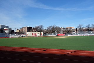
WEast River Park, also called John V. Lindsay East River Park, is 57.5-acre (20 ha) public park located on the Lower East Side of Manhattan, part of the New York City Department of Parks and Recreation. The park stretches along the East River from Montgomery Street up to 12th Street on the east side of the FDR Drive. The amphitheater, built in 1941 just south of Grand Street, has been reconstructed and is often used for public performances. The park includes football, baseball, and soccer fields; tennis, basketball, and handball courts; a running track; and bike paths, including the East River Greenway. Fishing is another popular activity. The park is bisected by the Williamsburg Bridge.
 W
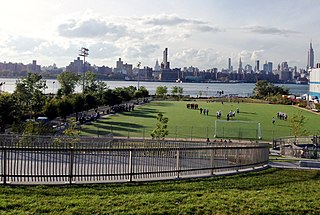
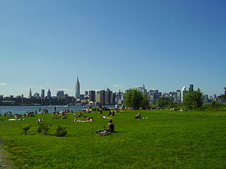
WMarsha P. Johnson State Park is an 11-acre (4.5 ha) state park in the Williamsburg neighborhood of Brooklyn, New York. The park stretches along the East River near North 7th, 8th, and 9th Streets, with views of the Williamsburg Bridge and Midtown Manhattan.
 W
WFerry Point Park is a 413.8-acre (167.5 ha) park in the Bronx, New York City. The park site is a peninsula projecting into the East River roughly opposite the College Point and Malba neighborhoods of Queens. The park is located on the eastern shore of Westchester Creek, adjacent to the neighborhood of Throggs Neck. The park is operated by the New York City Department of Parks and Recreation. The Hutchinson River Expressway crosses the park to the Bronx-Whitestone Bridge, splitting it into east and west sides.
 W
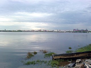
WFlushing Bay is a tidal embayment in New York City. It is located on the south side of the East River and stretches to the south near the neighborhood of Flushing, Queens. It is bordered on the west by LaGuardia Airport and the Grand Central Parkway, on the south by Northern Boulevard, and on the east by the neighborhood of College Point. The Flushing River empties into the bay at its southeast corner. A 150-foot-wide navigational channel (46 m) dredged at a depth of 14 feet (4.3 m) runs along much of the bay's length.
 W
WThe Flushing River, also known as Flushing Creek, is a waterway that flows northward through the borough of Queens in New York City, mostly within Flushing Meadows–Corona Park, emptying into the Flushing Bay and the East River. The river runs through a valley that may have been a larger riverbed before the last Ice Age, and it divides Queens into western and eastern halves. Until the 20th century, the Flushing Creek was fed by three tributaries: Mill Creek and Kissena Creek on the eastern bank, and Horse Brook on the western bank.
 W
WFort Totten is a former active United States Army installation in the New York City borough of Queens. It is located on the Willets Point peninsula on the north shore of Long Island. Fort Totten is at the head of Little Neck Bay, where the East River widens to become Long Island Sound. While the U.S. Army Reserve continues to maintain a presence at the fort, the property is now owned by the City of New York.
 W
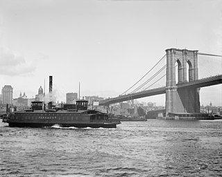
WThe Fulton Ferry was the first steam ferry route connecting Manhattan and Brooklyn, New York City, United States, joining Fulton Street, Manhattan, and Fulton Street, Brooklyn, across the East River. It revolutionized travel between the then City of New York on Manhattan Island and the Village of Brooklyn and the rest of Long Island. Robert Fulton's steam Fulton Ferry Company in 1814 established his name on the ferry service. After the Brooklyn Bridge was built, ridership declined, and the ferry ceased operation on January 19, 1924. NYC Ferry now serves a very similar route.
 W
WThe Gouverneur Street Ferry was a ferry route connecting Manhattan, New York City, with the city of Brooklyn, by joining Manhattan's Gouverneur Street to Brooklyn's Bridge Street across the East River.
WThe Grand Street Ferry was a ferry route connecting Manhattan and Williamsburg, Brooklyn, New York City, joining Grand Street (Manhattan) and Grand Street (Brooklyn) across the East River.
 W
WHell Gate is a narrow tidal strait in the East River in New York City. It separates Astoria, Queens from Randall's and Wards Islands.
 W
WHorse Brook is a buried stream located in the neighborhood of Elmhurst in the New York City borough of Queens. Its historic course flows beneath Queens Center Mall, Rego Center Mall, LeFrak City, and the Long Island Expressway, before emptying into Flushing Creek in present-day Flushing Meadows-Corona Park. Flushing Creek is a tributary of the East River.
WThe Houston Street Ferry was a ferry route connecting Manhattan and Williamsburg, Brooklyn, New York City, United States, joining Houston Street (Manhattan) and Grand Street (Brooklyn) across the East River.
 W
WKissena Creek is a buried stream located in the neighborhoods of Flushing, Fresh Meadows, Hillcrest, and Kew Gardens Hills in the New York City borough of Queens. Kissena Creek originates in a now-filled swamp within Kew Gardens Hills and Pomonok in central Queens, flowing east to Hillcrest. The creek then travels mostly north and west, largely flowing beneath Kissena Park Golf Course, Kissena Park, Kissena Corridor Park, and Queens Botanical Garden, before merging with the Flushing River in Flushing Meadows–Corona Park.
 W
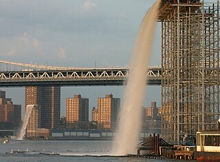
WNew York City Waterfalls is a public art project by artist Olafur Eliasson, in collaboration with the Public Art Fund, consisting of four man-made waterfalls placed around New York City along the East River. The most famous was at the Brooklyn Bridge in lower Manhattan. At $15.5 million, it is the most expensive public arts project since Christo and Jeanne-Claude's installation of The Gates in Central Park. The waterfalls officially began flowing on June 26, 2008. They ran from 7 am to 10 pm, until October 13, 2008.
 W
WNew York Skyports Inc. Seaplane base is a seaplane base in the East River VFR corridor in New York City, located at the foot of East 23rd Street between Waterside Plaza and Stuyvesant Cove Park. A seaplane ramp was constructed at East 23rd Street in the mid-1930s and the seaplane base became part of the marina that opened on April 18, 1962.
 W
WNewtown Creek, a 3.5-mile (6-kilometer) long tributary of the East River, is an estuary that forms part of the border between the boroughs of Brooklyn and Queens, in New York City. Channelization made it one of the most heavily used bodies of water in the Port of New York and New Jersey and thus one of the most polluted industrial sites in the US, containing years of discarded toxins, an estimated 30,000,000 US gallons of spilled oil, including the Greenpoint oil spill, raw sewage from New York City’s sewer system, and other accumulation from a total of 1,491 sites.
 W
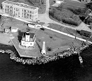
WNorth Brother Island Light was a lighthouse located on North Brother Island in the East River in New York City. The lighthouse was at the southern tip of the island. Before the lighthouse was erected, the island was uninhabited and saw no formal use. The tower utilized an occulting light which lit for five seconds and eclipsed for five seconds. It stood 47 feet above the water.
WThe Peck Slip Ferry was a pre-Brooklyn Bridge ferry route connecting Manhattan and Williamsburg, Brooklyn, New York City, United States, joining Peck Slip (Manhattan) and Broadway (Brooklyn) across the East River.
 W
WPier 42 is a pier in the Lower East Side of Manhattan, New York City. It was the last working cargo pier on the Manhattan shore of the East River, operating from 1963 to 1987. Since the early 2010s, plans have been underway to turn Pier 42 into a park.
 W
WIn 1851, the U.S. Army Corps of Engineers led by General John Newton began to clear obstacles from Hell Gate, a strait in New York City's East River, with explosives. The operation would last 70 years. On September 24, 1876, the Corps used 50,000 pounds (23,000 kg) of explosives to blast the rocks, which was followed by further blasting. The process was started by excavating under Hallets reef from Astoria. Cornish miners assisted by steam drills dug galleries under the reef, which were then interconnected. They later drilled holes for explosives. A patent was issued for the detonating device. After the explosion the rock debris was dredged and dropped in a deep part of the river, this was not repeated at the later Flood rock explosion.
 W
WThe Roosevelt Island Tramway is an aerial tramway in New York City that spans the East River and connects Roosevelt Island to the Upper East Side of Manhattan. The tramway is the first commuter aerial tramway in North America, having opened in 1976. Since then, over 26 million passengers have ridden the tram.
 W
WSouth Ferry is at the southern tip of Manhattan in New York City and is the embarkation point for ferries to Staten Island and Governors Island. Battery Park, abutting South Ferry on the west, has docking areas for ferries to Liberty Island and Ellis Island. Its name is derived from an historical ferry company which provided service to Brooklyn, run by the South Ferry Company.
 W
WStuyvesant Cove Park is a 1.9-acre (7,700 m2) public park on the East Side of the New York City borough of Manhattan that runs from 18th Street to 23rd Street between the FDR Drive and the East River. Part of the East River Greenway, it is located to the south of the Waterside Plaza apartment complex, to the east of Stuyvesant Town–Peter Cooper Village, and to the north of the East River Park, and connects to the Captain Patrick J. Brown Walk on the south end.
 W
WSunswick Creek is a buried stream located in Astoria and Long Island City, in the northwestern portion of Queens in New York City. It originated to the north of Queensboro Bridge and Queens Plaza in Long Island City, flowing north to the present-day site of the Socrates Sculpture Park in Astoria, and emptying into the East River. The creek was named for a term in the Algonquin language that likely means "Woman Chief" or "Sachem’s Wife."
 W
WWaterside Plaza is a residential and business complex located on the East River in the Kips Bay section of Manhattan, New York City. It was formerly a Mitchell-Lama Housing Program-funded rental project.
 W
WWNYC Transmitter Park is a 6.61-acre public park located in the Greenpoint neighborhood of Brooklyn, New York City, where Greenpoint Avenue dead-ends by the East River shoreline. The site was acquired by the public radio station WNYC in 1935 as the site of twin antennas used for broadcasting. From 1937 to 1990, the city-operated station broadcast its AM signal from this location. Following the adoption of antennas in Kearny, New Jersey and atop the World Trade Center, the Greenpoint property sat unused. Construction on WNYC Transmitter Park began in August 2010 and the park opened two years later in September 2012.