 W
WThis is a list of United States National Parks by elevation. Most of America's national parks are located in mountainous areas. Even among those located close to the ocean, not all are flat. Those few that are low-lying preserve important natural habitats that could never exist at high altitude. Several national parks protect deep canyons with great vertical relief. There are also three national parks whose primary features are caves, the depths of which are still being explored.
 W
WCadillac Mountain is located on Mount Desert Island, within Acadia National Park, in the U.S. state of Maine. With an elevation of 1,530 feet, its summit is the highest point in Hancock County and the highest within 25 miles (40 km) of the Atlantic shoreline of the North American continent between the Cape Breton Highlands, Nova Scotia and peaks in Mexico. It is known as the first place in the U.S. to see the sunrise, although that is only true for a portion of the year.
 W
WMount Cleveland is the highest mountain in Glacier National Park, located in Montana, United States. It is also the highest point in the Lewis Range, which spans part of the northern portion of the Park and extends into Canada. It is located approximately 3 mi (4.8 km) southeast of the southern end of Waterton Lake, and approximately 5 mi (8.0 km) south of the US/Canada border. The east side of the future national park was purchased by the federal government from the Blackfoot Confederacy in 1895 during the second term of President Cleveland. According to the United States Board on Geographic Names, the mountain is named for the former president.
 W
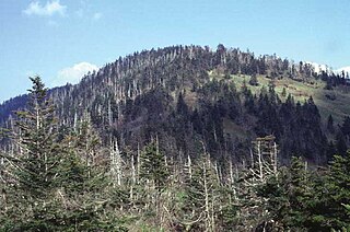
WClingmans Dome is a mountain in the Great Smoky Mountains of Tennessee and North Carolina, in the southeastern United States. At an elevation of 6,643 feet (2,025 m), it is the highest mountain in the Great Smoky Mountains National Park, the highest point in the state of Tennessee, and the highest point along the 2,192-mile (3,528 km) Appalachian Trail. It is also the third highest point in mainland Eastern North America, after the nearby Mount Mitchell and Mount Craig.
 W
WDenali is the highest mountain peak in North America, with a summit elevation of 20,310 feet (6,190 m) above sea level. With a topographic prominence of 20,156 feet (6,144 m) and a topographic isolation of 4,629 miles (7,450 km), Denali is the third most prominent and third most isolated peak on Earth, after Mount Everest and Aconcagua. Located in the Alaska Range in the interior of the U.S. state of Alaska, Denali is the centerpiece of Denali National Park and Preserve.
 W
WMount Denison is a stratovolcano and one of the highest peaks on the Alaska Peninsula. Discovered in 1923 by Harvard professor Kirtley Fletcher Mather, the mountain was named for the geologist's alma mater, Denison University. The mountain's connection to Denison also include its first climbers: all members of the first two ascent teams as well as the group that attempted in 1977 were either students, alumni, or faculty of the University.
 W
WMount Desor is the tallest mountain within Isle Royale National Park. Located on Isle Royale in Lake Superior and with an elevation of 1,394 feet (420 m), it is the third highest peak on the lake.
 W
WEagle Peak is a mountain in the Absaroka Range in the U.S. state of Wyoming and at 11,372 feet (3,466 m) is the highest point in Yellowstone National Park. It is located about 6 miles (9.7 km) east of the southeast arm of Yellowstone Lake.
 W
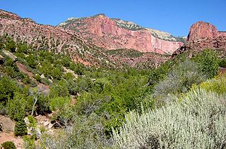
WElephant Butte is a 5,653-ft summit in Grand County, Utah. It is located within Arches National Park, and is the highest point in the park. Like many of the rock formations in the park, Elephant Butte is composed of Entrada Sandstone. Elephant Butte is a flat-topped cap surrounded by numerous towers and fins including Parade of Elephants. Double Arch is also a natural feature of Elephant Butte and was used as a backdrop for the opening scene of Indiana Jones and the Last Crusade. Precipitation runoff from Elephant Butte drains east into the nearby Colorado River. The first ascent was made September 8, 1953, by Alex Cresswell and Fred Ayres.
 W
WEmory Peak, located in Big Bend National Park, is the highest peak in the Chisos Mountains and the highest in Brewster County. The peak is named for William H. Emory, the chief surveyor of the U.S. Boundary Survey team of 1852. From the Chisos Basin the peak appears to be a minor ridge, while the summit of Casa Grande, one mile closer, seems to be much taller. From the west, Emory Peak is clearly visible as a point slightly higher than most of the mountain range.
 W
WMount Fairweather, is the highest mountain in the Canadian province of British Columbia, with an elevation of 4,671 metres (15,325 ft). It is located 20 km (12 mi) east of the Pacific Ocean on the border of Alaska, United States and western British Columbia, Canada. Most of the mountain lies within Glacier Bay National Park and Preserve in the City and Borough of Yakutat, Alaska (USA), though the summit borders Tatshenshini-Alsek Provincial Park, British Columbia (Canada). It is also designated as Boundary Peak 164 or as US/Canada Boundary Point #164.
 W
WGoode Mountain is one of the major peaks of the North Cascades in the U.S. state of Washington. Named for topographer Richard U. Goode of the USGS, it is the highest peak located in North Cascades National Park, between the Skagit River and Lake Chelan. It is the fourth-highest non-volcanic peak in Washington, and the twelfth-highest summit overall.
 W
WGrand Teton is the highest mountain in Grand Teton National Park, in Northwest Wyoming, and a classic destination in American mountaineering.
 W
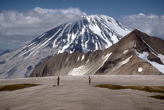
WMount Griggs, formerly known as Knife Peak Volcano, is a stratovolcano, which lies 10 km behind the volcanic arc defined by other Katmai group volcanoes. Although no historic eruptions have been reported from Mount Griggs, vigorously active fumaroles persist in a summit crater and along the upper southwest flank. The fumaroles on the southwest flank are the hottest, and some of the flank fumaroles can roar so loudly that they can be heard from the valley floor. The slopes of Mount Griggs are heavily mantled by fallout from the 1912 eruption of Novarupta volcano. The summit consists of three concentric craters, the lowest and largest of which contains a recent summit cone topped by two craters. The volume of the volcanic edifice is estimated at about 25 cubic kilometers (6.0 cu mi). Isotopic analysis indicates that the source of Griggs' magma is distinct from the other Katmai volcanoes.
 W
WGuadalupe Peak, also known as Signal Peak, is the highest natural point in Texas, with an elevation of 8,751 feet (2,667 m) above sea level. It is located in Guadalupe Mountains National Park, and is part of the Guadalupe Mountains range in southeastern New Mexico and West Texas. The mountain is about 90 miles (140 km) east of El Paso and about 50 miles (80 km) southwest of Carlsbad, New Mexico. The peak rises more than 3,000 feet (910 m) above the arid floor of the Chihuahuan Desert.
 W
WHaleakalā, or the East Maui Volcano, is a massive shield volcano that forms more than 75% of the Hawaiian Island of Maui. The western 25% of the island is formed by another volcano, Mauna Kahalawai, also referred to as the West Maui Mountains.
 W
WHawksbill Mountain is a mountain with an elevation of 4,050 feet (1,234 m). Marking the border between Madison County and Page County in Virginia, the summit of Hawksbill Mountain is the highest point in Shenandoah National Park, as well as the highest point in both Madison and Page counties.
 W
WHorse Ranch Mountain is an 8,733-foot (2,662 m) mountain in the Kolob Canyons section of Zion National Park in northeastern Washington County, Utah, United States, that is the highest summit within the national park. It rises above Camp Creek to the north and Taylor Creek to the south. Its neighbors include Tucupit Point, 1 mi (1.6 km) to the south, and Timber Top Mountain is situated 3.9 mi (6.3 km) to the south-southwest.
 W
WMount Igikpak is the highest peak in the Schwatka Mountains region of the Brooks Range. It is also the tallest mountain in Gates of the Arctic National Park, located in the US state of Alaska. Some sources list the height of its summit at 8,510'. Mount Igikpak is in the south central part of the national park, very close to the source of the Noatak River and not far from the Arrigetch Peaks.
 W
WLassen Peak, commonly referred to as Mount Lassen, is the southernmost active volcano in the Cascade Range of the Western United States. Located in the Shasta Cascade region of Northern California, it is part of the Cascade Volcanic Arc, which stretches from southwestern British Columbia to northern California. Lassen Peak reaches an elevation of 10,457 feet (3,187 m), standing above the northern Sacramento Valley. It supports many flora and fauna among its diverse habitats, which are subject to frequent snowfall and reach high elevations.
 W
WLata Mountain is the highest point of American Samoa, on the island of Ta'u, and is located in the Manu'a Islands.
 W
WLongs Peak is a high and prominent mountain in the northern Front Range of the Rocky Mountains of North America. The 14,259-foot (4346 m) fourteener is located in the Rocky Mountain National Park Wilderness, 9.6 miles (15.5 km) southwest by south of the Town of Estes Park, Colorado, United States. Longs Peak is the northernmost fourteener in the Rocky Mountains and the highest point in Boulder County and Rocky Mountain National Park. The mountain was named in honor of explorer Stephen Harriman Long and is featured on the Colorado state quarter.
 W
WMount Lyell is the highest point in Yosemite National Park, at 13,114 feet (3,997 m). It is located at the southeast end of the Cathedral Range, 1.2 miles (1.9 km) northwest of Rodgers Peak. The peak as well as nearby Lyell Canyon is named after Charles Lyell, a well-known 19th century geologist. The peak had one of the last remaining glaciers in Yosemite, Lyell Glacier. The Lyell Glacier is currently considered to be a permanent ice field, not a living glacier. Mount Lyell divides the Tuolumne River watershed to the north, the Merced to the west, and the Rush Creek drainage in the Mono Lake Basin to the southeast.
 W
WMauna Loa is one of five volcanoes that form the Island of Hawaii in the U.S. state of Hawaiʻi in the Pacific Ocean. The largest subaerial volcano in both mass and volume, Mauna Loa has historically been considered the largest volcano on Earth, dwarfed only by Tamu Massif. It is an active shield volcano with relatively gentle slopes, with a volume estimated at approximately 18,000 cubic miles (75,000 km3), although its peak is about 125 feet (38 m) lower than that of its neighbor, Mauna Kea. Lava eruptions from Mauna Loa are silica-poor and very fluid, and they tend to be non-explosive.
 W
WMica Mountain is a 8,668-foot (2,642 m) peak in the Rincon Mountain District of Saguaro National Park in Pima County, Arizona, about 20 miles (32 km) east of Tucson. It is the highest point of the park and the highest point in the Rincon Mountains.
 W
WNorth Palisade is the third highest mountain in the Sierra Nevada range of California. It is the highest peak of the Palisades group of peaks in the central part of the range. It sports a small glacier and several highly prized rock climbing routes on its northeast side.
 W
WMount Olympus, at 7,980 feet, is the tallest and most prominent mountain in the Olympic Mountains of western Washington state. Located on the Olympic Peninsula, it is also the central feature of Olympic National Park. Mount Olympus is the highest summit of the Olympic Mountains; however, peaks such as Mount Constance and The Brothers, on the eastern margin of the range, are better known, being visible from the Seattle metropolitan area.
 W
WQuail Mountain, at 5,816 feet (1,773 m), is the highest mountain in Joshua Tree National Park and the highest point in the Little San Bernardino Mountains of the very southern reach of the Mojave Desert. It is one of the southernmost peaks in the Transverse Ranges, with the Peninsular Ranges just across the Colorado Desert and Coachella Valley.
 W
WMount Rainier, also known as Tahoma or Tacoma, is a large active stratovolcano in the Cascade Range of the Pacific Northwest, located in Mount Rainier National Park about 59 miles (95 km) south-southeast of Seattle. With a summit elevation of 14,411 ft (4,392 m), it is the highest mountain in the U.S. state of Washington and the Cascade Range, the most topographically prominent mountain in the contiguous United States, and the tallest in the Cascade Volcanic Arc.
 W
WRedoubt Volcano, or Mount Redoubt, is an active stratovolcano in the largely volcanic Aleutian Range of the U.S. state of Alaska. Located at the head of the Chigmit Mountains subrange in Lake Clark National Park and Preserve, the mountain is just west of Cook Inlet, in the Kenai Peninsula Borough about 110 miles (180 km) southwest of Anchorage. At 10,197 feet (3,108 m), in just over 5 miles (8 km) Mount Redoubt attains 9,150 feet (2,700 m) of prominence over its surrounding terrain. It is the highest summit in the Aleutian Range. In 1976, Redoubt Volcano was designated as a National Natural Landmark by the National Park Service.
 W
WMount Saint Elias, also designated Boundary Peak 186, is the second highest mountain in both Canada and the United States, being situated on the Yukon and Alaska border. It lies about 26 miles (42 km) southwest of Mount Logan, the highest mountain in Canada. The Canadian side is part of Kluane National Park and Reserve, while the U.S. side of the mountain is located within Wrangell-St. Elias National Park and Preserve.
 W
WMount Scott is a small stratovolcano and a so-called parasitic cone on the southeast flank of Crater Lake in southern Oregon. It is approximately 420,000 years old. Its summit is the highest point within Crater Lake National Park, and the tenth highest peak in the Oregon Cascades. A small fire lookout tower stands on the summit, at the end of a trail that zigzags approximately 1,500 feet up the mountain. The mountain is named for Oregon pioneer Levi Scott, founder of Scottsburg, Oregon.
 W
WTelescope Peak is the highest point within Death Valley National Park, in the U.S. state of California. It is also the highest point of the Panamint Range, and lies in Inyo County. From atop this desert mountain one can see for over one hundred miles in many directions, including west to Mount Whitney, and east to Charleston Peak. The mountain was named for the great distance visible from the summit.
 W
WTijeras Peak is a high mountain summit in the Sangre de Cristo Range of the Rocky Mountains of North America. The 13,610-foot (4,148 m) thirteener is located 9.8 miles (15.8 km) southeast by east of the Town of Crestone in Saguache County, Colorado, United States, in the Sangre de Cristo Wilderness on the boundary between Great Sand Dunes National Preserve and Rio Grande National Forest. Tijeras Peak is the highest summit in Great Sand Dunes National Park and Preserve. Tijeras is Spanish for scissors, and refers to the double-pronged rocky tip of the mountain.
 W
WWheeler Peak is the tallest mountain in the Snake Range and in White Pine County, in Nevada, United States. The summit elevation of 13,065 feet (3,982 m) makes it the second-highest peak in Nevada, just behind Boundary Peak. With a topographic prominence of 7,563 feet (2,305 m), Wheeler Peak is the most topographically prominent peak in White Pine County and the second-most prominent peak in Nevada, just behind Mount Charleston. The mountain is located in Great Basin National Park and was named for George Wheeler, leader of the Wheeler Survey of the late 19th century.
 W
WMount Whitney is the tallest mountain in the contiguous United States and the Sierra Nevada, with an elevation of 14,505 feet (4,421 m). It is in East–Central California, on the boundary between California's Inyo and Tulare counties, 84.6 miles (136.2 km) west-northwest of North America's lowest point, Badwater Basin in Death Valley National Park, at 282 ft (86 m) below sea level. The mountain's west slope is in Sequoia National Park and the summit is the southern terminus of the John Muir Trail, which runs 211.9 mi (341.0 km) from Happy Isles in Yosemite Valley. The eastern slopes are in Inyo National Forest in Inyo County.