 W
WMontane ecosystems are found on the slopes of mountains. The alpine climate in these regions strongly affect the ecosystem because temperatures fall as elevation increases, causing the ecosystem to stratify. Dense montane forests are common at moderate elevations, due to moderate temperatures and high rainfall. At higher elevations, the climate is harsher, with lower temperatures and higher winds, preventing the growth of trees and causing the plant community to transition to montane grasslands, shrublands or alpine tundra.
 W
WAlpine climate is the typical weather (climate) for the regions above the tree line. This climate is also referred to as a mountain climate or highland climate.
 W
WAlpine lakes are classified as lakes at high altitudes, usually starting around 10,000 feet in elevation above sea level or above the tree line.
 W
WAlpine plants are plants that grow in an alpine climate, which occurs at high elevation and above the tree line. There are many different plant species and taxon that grow as a plant community in these alpine tundra. These include perennial grasses, sedges, forbs, cushion plants, mosses, and lichens. Alpine plants are adapted to the harsh conditions of the alpine environment, which include low temperatures, dryness, ultraviolet radiation, wind, drought, poor nutritional soil, and a short growing season.
 W
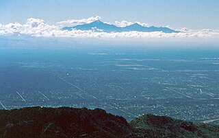
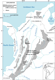
WThe Altiplano, Collao or Andean Plateau, in west-central South America, is the area where the Andes are the widest. It is the most extensive area of high plateau on Earth outside Tibet. The bulk of the Altiplano lies in Bolivia, but its northern parts lie in Peru, and its southern parts lie in Chile and Argentina.
 W
WCentral Europe contains several life zones, depending on location and elevation.
 W
WClimate of Peru describes the diverse climates of this large South American country with an area of 1,285,216 km2 (496,225 sq mi). Peru is located entirely in the tropics but features desert and mountain climates as well as tropical rain forests. Elevations above sea level in the country range from −37 metres (−121 ft) to 6,788 metres (22,270 ft) and precipitation ranges from less than 20 millimetres (0.79 in) annually to more than 8,000 millimetres (310 in). There are three main climatic regions: the Pacific Ocean coast is one of the driest deserts in the world but with some unique features; the high Andes mountains have a variety of microclimates depending on elevation and exposure and with temperatures and precipitation from temperate to polar and wet to dry; and the Amazon Basin has tropical climates, mostly with abundant precipitation, along with sub-tropical climates in elevations above 1,550 metres (5,090 ft).
 W
WA couloir, is a narrow gully with a steep gradient in a mountainous terrain.
 W
WA fellfield or fell field comprises the environment of a slope, usually alpine or tundra, where the dynamics of frost and of wind give rise to characteristic plant forms in scree interstices.
 W
WA fir wave is a set of alternating bands of fir trees in sequential stages of development, observed in forests on exposed mountain slopes in several areas, including northeastern North America and Japan. Fir waves develop by wave-regeneration following wind disturbance, and is one of various types of patterned vegetation.
 W
WFirn is partially compacted névé, a type of snow that has been left over from past seasons and has been recrystallized into a substance denser than névé. It is ice that is at an intermediate stage between snow and glacial ice. Firn has the appearance of wet sugar, but has a hardness that makes it extremely resistant to shovelling. Its density generally ranges from 0.4 g/cm³ to 0.83 g/cm³, and it can often be found underneath the snow that accumulates at the head of a glacier.
 W
WThe freezing level, or 0 °C (zero-degree) isotherm, represents the altitude in which the temperature is at 0 °C in a free atmosphere. Any given measure is valid for only a short period of time, often less than a day.
 W
WA glacial stream is a channelized accumulation of liquid water which flow in a channel formed by a glacier. Depending on where they flow, they can be classified into supraglacial, englacial and subglacial streams.
 W
WA glacier is a persistent body of dense ice that is constantly moving under its own weight. A glacier forms where the accumulation of snow exceeds its ablation over many years, often centuries. Glaciers slowly deform and flow under stresses induced by their weight, creating crevasses, seracs, and other distinguishing features. They also abrade rock and debris from their substrate to create landforms such as cirques and moraines. Glaciers form only on land and are distinct from the much thinner sea ice and lake ice that forms on the surface of bodies of water.
 W
WHill people, also referred to as mountain people, is a general term for people who live in the hills and mountains. This includes all rugged land above 300 metres (980 ft) and all land above 2,500 metres (8,200 ft) elevation. The climate is generally harsh, with steep temperature drops between day and night. High winds, runoff from melting snow and rain cause high levels of erosion and thin, immature soils. Climate change is likely to place considerable stress on the mountain environment and the people who live there.
 W
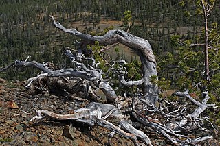
WKrummholz or krumholtz — also called knieholz — is a type of stunted, deformed vegetation encountered in the subarctic and subalpine tree line landscapes, shaped by continual exposure to fierce, freezing winds. Under these conditions, trees can only survive where they are sheltered by rock formations or snow cover. As the lower portion of these trees continues to grow, the coverage becomes extremely dense near the ground. In Newfoundland and Labrador, the formation is known as tuckamore. Krummholz trees are also found on beaches such as the Oregon coast, where trees can become much taller than their subalpine cousins.
 W
WWhen the Spanish arrived, they divided Peru into three main regions: the coastal region, that is bounded by the Pacific Ocean; the highlands, that is located on the Andean Heights, and the jungle, that is located on the Amazonian Jungle. But Javier Pulgar Vidal (es), a geographer who studied the biogeographic reality of the Peruvian territory for a long time, proposed the creation of eight Natural Regions. In 1941, he presented his thesis "Las Ocho Regiones Naturales del Perú" at the III General Assembly of the Pan-American Institute of Geography and History.
WThe climate and ecology of land immediately surrounding the Mediterranean Sea is influenced by several factors. Overall, the land has a Mediterranean climate, with mild, rainy winters and hot, dry summers. The climate induces characteristic Mediterranean forests, woodlands, and scrub vegetation. Plant life immediately near the Mediterranean is in the Mediterranean Floristic region, while mountainous areas further from the sea supports the Sub-Mediterranean Floristic province.
 W
WMontane grasslands and shrublands is a biome defined by the World Wildlife Fund. The biome includes high altitude grasslands and shrublands around the world. The term "montane" in the name of the biome refers to "high altitude", rather than the ecological term which denotes the region below treeline.
 W
WA mountain pass is a navigable route through a mountain range or over a ridge. Since many of the world's mountain ranges have presented formidable barriers to travel, passes have played a key role in trade, war, and both human and animal migration throughout history. At lower elevations it may be called a hill pass.
 W
WThe Ecology of the North Cascades is heavily influenced by the high elevation and rain shadow effects of the mountain range. The North Cascades is a section of the Cascade Range from the South Fork of the Snoqualmie River in Washington, United States, to the confluence of the Thompson and Fraser Rivers in British Columbia, Canada, where the range is officially called the Cascade Mountains but is usually referred to as the Canadian Cascades. The North Cascades Ecoregion is a Level III ecoregion in the Commission for Environmental Cooperation's classification system.
 W
WPáramo can refer to a variety of alpine tundra ecosystems. Some ecologists describe the páramo broadly as "all high, tropical, montane vegetation above the continuous timberline". A more narrow term classifies the páramo according to its regional placement in the northern Andes of South America and adjacent southern Central America. The páramo is the ecosystem of the regions above the continuous forest line, yet below the permanent snowline. It is a "Neotropical high mountain biome with a vegetation composed mainly of giant rosette plants, shrubs and grasses". According to scientists, páramos may be "evolutionary hot spots" and among the fastest evolving regions on Earth.
 W
WPermafrost is ground that continuously remains below 0°C (32°F) for two or more years, located on land or under the ocean. Permafrost does not have to be the first layer that is on the ground. It can be from an inch to several miles deep under the Earth's surface. Some of the most common permafrost locations are in the Northern Hemisphere. Almost a quarter of the Northern Hemisphere is underlain by permafrost, including 85% of Alaska, Greenland, Canada and Siberia. It can also be located on mountaintops in the Southern Hemisphere. Permafrost frequently occurs in ground ice, but it can also be present in non-porous bedrock. Permafrost is formed from ice holding various types of soil, sand, and rock in combination.
 W
WQuechua is one of the eight Natural Regions of Peru and is between 2,300 and 3,500 m above sea level. It is composed of big valleys divided by rivers fed by estival rains.
 W
WThe retreat of glaciers since 1850 affects the availability of fresh water for irrigation and domestic use, mountain recreation, animals and plants that depend on glacier-melt, and, in the longer term, the level of the oceans. Studied by glaciologists, the temporal coincidence of glacier retreat with the measured increase of atmospheric greenhouse gases is often cited as an evidentiary underpinning of global warming. Mid-latitude mountain ranges such as the Himalayas, Rockies, Alps, Cascades, and the southern Andes, as well as isolated tropical summits such as Mount Kilimanjaro in Africa, are showing some of the largest proportionate glacial losses.
 W
WA ridge or a mountain ridge is a geographical feature consisting of a chain of mountains or hills that form a continuous elevated crest for some distance. The sides of the ridge slope away from narrow top on either side. The lines along the crest formed by the highest points, with the terrain dropping down on either side, are called the ridgelines. Ridges are usually termed hills or mountains as well, depending on size.
 W
WRupa-Rupa or High Jungle is one of the eight natural regions of Peru. It is located between 400 and 1,000 m above the sea level. This region has many long, narrow valleys and fluvial mountain trails. The weather is warm, humid, and rainy.
 W
WScree is a collection of broken rock fragments at the base of crags, mountain cliffs, volcanoes or valley shoulders that has accumulated through periodic rockfall from adjacent cliff faces. Landforms associated with these materials are often called talus deposits. Talus deposits typically have a concave upwards form, while the maximum inclination corresponds to the angle of repose of the mean debris size.
 W
WSky islands are isolated mountains surrounded by radically different lowland environments. The term originally referred to those found near the southern borders of Arizona and New Mexico, and has extended to similarly isolated high-altitude forests. The isolation has significant implications for these natural habitats. The American Southwest region began warming up between ∼20,000–10,000 years BP and atmospheric temperatures increased substantially, resulting in the formation of vast deserts that isolated the Sky Islands. Endemism, altitudinal migration, and relict populations are some of the natural phenomena to be found on sky islands.
 W
WThe climatic snow line is the boundary between a snow-covered and snow-free surface. The actual snow line may adjust seasonally, and be either significantly higher in elevation, or lower. The permanent snow line is the level above which snow will lie all year.
 W
WSuni or Jalca is one of the eight Natural Regions of Peru. It is located in the Andes at an altitude between 3,500 and 4,000 metres above sea level. Suni has a dry and cold weather and there are many glacial valleys.
 W
WThe Tibetan Plateau, also known in China as the Qinghai–Tibet Plateau or the Qing–Zang Plateau or as the Himalayan Plateau in India, is a vast elevated plateau in South Asia, Central Asia and East Asia, covering most of the Tibet Autonomous Region, Northwestern Yunnan, Western half of Sichuan, Southern Gansu and Qinghai provinces in Western China, Indian regions of Ladakh and Lahaul and Spiti as well as Bhutan. It stretches approximately 1,000 kilometres (620 mi) north to south and 2,500 kilometres (1,600 mi) east to west. It is the world's highest and largest plateau, with an area of 2,500,000 square kilometres (970,000 sq mi). With an average elevation exceeding 4,500 metres (14,800 ft) and being surrounded by imposing mountain ranges that harbor the world's two highest summits, Mount Everest and K2, the Tibetan Plateau is often referred to as "the Roof of the World".
 W
WIn Latin America, tierra fría are mountain locations where high elevation results in a markedly cooler climate than that encountered in the lowlands at a comparable latitude. The combination of low latitude and high altitude — typically between approximately 2,000 m and 3,500 m in locations within 10° of the equator — produces a climate that falls into the same category as many oceanic climates found along the west coasts of the continents within the temperate zones — mild temperatures all year round, with monthly averages ranging from about 10°C (50°F) in the coldest months to about 18°C (64.4°F) in the warmest months. Common crops grown in the tierra fría are potatoes, wheat, barley, oats, corn, and rye.
 W
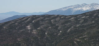
WThe tree line is the edge of the habitat at which trees are capable of growing. It is found at high elevations and high latitudes. Beyond the tree line, trees cannot tolerate the environmental conditions. The tree line is sometimes distinguished from a lower timberline or forest line, which is the line below which trees form a forest with a closed canopy.
 W
WThe Yukon Ice Patches are a series of dozens of ice patches in the southern Yukon discovered in 1997, which have preserved hundreds of archaeological artifacts, with some more than 9,000 years old. The first ice patch was discovered on the mountain Thandlät, west of the Kusawa Lake campground which is 60 km (37 mi) west of Whitehorse, Yukon. The Yukon Ice Patch Project began shortly afterwards with a partnership between archaeologists in partnership with six Yukon First Nations, on whose traditional territory the ice patches were found. They include the Carcross/Tagish First Nation, the Kwanlin Dün First Nation, the Ta’an Kwäch’än Council, the Champagne and Aishihik First Nations, the Kluane First Nation, and the Teslin Tlingit Council.
 W
WThe Yungas is a narrow band of forest along the eastern slope of the Andes Mountains from Peru, Bolivia, and northern Argentina. It is a transitional zone between the Andean highlands and the eastern forests. Like the surrounding areas, the Yungas belong to the Neotropical realm; the climate is rainy, humid, and warm.